Bridge Statistics for Troy, New York (NY)
Condition, Traffic, Stress, Structural Evaluation, Project Costs
- National Bridge Inventory (NBI) Statistics
- 27Number of bridges
- 715ft / 218mTotal length
- $233,800,000Total costs
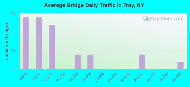
- 321,879Total average daily traffic
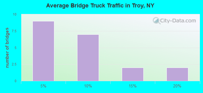
- 15,415Total average daily truck traffic
- National Bridge Inventory (NBI) Registered Bridges for Troy
- No street view available for this location
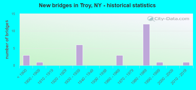
- New bridges - historical statistics
- 3Before 1900
- 11900-1909
- 61930-1939
- 31960-1969
- 121980-1989
- 11990-1999
- 12010-2019
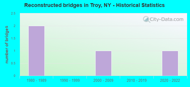
- Reconstructed bridges - Historical Statistics
- 21980-1989
- 01990-1999
- 12000-2009
- 02010-2019
- 12020-2022
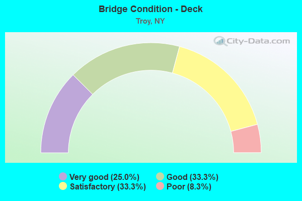
- Bridge Condition - Deck
- 25.0%Very good
- 33.3%Good
- 33.3%Satisfactory
- 8.3%Poor
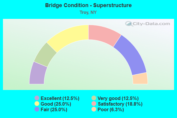
- Bridge Condition - Superstructure
- 12.5%Excellent
- 12.5%Very good
- 25.0%Good
- 18.8%Satisfactory
- 25.0%Fair
- 6.3%Poor
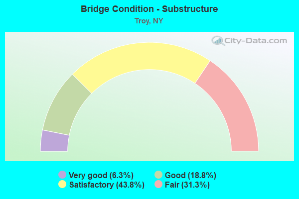
- Bridge Condition - Substructure
- 6.3%Very good
- 18.8%Good
- 43.8%Satisfactory
- 31.3%Fair
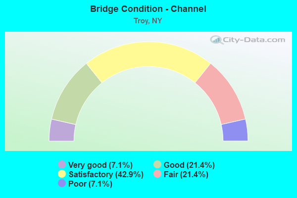
- Bridge Condition - Channel
- 7.1%Very good
- 21.4%Good
- 42.9%Satisfactory
- 21.4%Fair
- 7.1%Poor
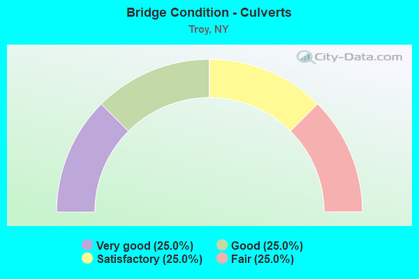
- Bridge Condition - Culverts
- 25.0%Very good
- 25.0%Good
- 25.0%Satisfactory
- 25.0%Fair
Find on map >> Show street view
Structure Number: 100016, Location: BURDEN AVE RT378 S.TROY (Lat: 42.704236, Lng: -73.696464), Route carried "on" structure: City street 378, Year Built: 1932, Status: Open, Structure Length: 1.28m (4.20ft), Average Daily Traffic: 23,843 (year 2010), Truck Traffic: 5%, Average Future Daily Traffic: 27,629 (year 2040), Features Intersected: WYNANTS KILL
Minimum Vertical Clearance: 30+ m (98+ ft), Kilometerpoint: 0.692, Lanes on structure: 4, Base Highway Network: Yes, Owner: State Highway Agency, Approaching Roadway Width: 13.7m (44.9ft), Material/Design: Concrete, Design/Construction: Tee Beam, Number Of Spans In Main Unit: 1, Length of Maximum Span: 12.1m (39.7ft), Curb or Sidewalk Widths: Left: 2.4m (7.9ft), Right: 2.4m (7.9ft), Curb-To-Curb Width: 29.9m (98.1ft), Out-to-Out Width: 35.7m (117.1ft)
Condition: Deck: Satisfactory, Superstructure: Satisfactory, Substructure: Satisfactory, Channel: Good, Operating Rating: 73.5 metric tons, Method Used To Determine Operating Rating: Load Factor (LF), Inventory Rating: 43.5 metric tons, Method Used To Determine Inventory Rating: Load Factor (LF), Structural Evaluation: Equal to present minimum criteria, Deck Geometry: Superior to present desirable criteria, Waterway Adequacy: Meets minimum limits, Approach Roadway Alignment: Equal to present minimum criteria, Length Of Structure Improvement: 1.28m (4.20ft), Designated Inspection Frequency: Every 24 months, Inspection Date: August 2021, Bridge Improvement Cost: $3,235,000, Roadway Improvement Cost: $1,895,000, Total Project Cost: $5,130,000 ( Estimate for 2021), Deck Structure Type: Concrete Cast-file-Place, Wearing Surface/Protective System: Wearing Surface: Bituminous, Membrane: Preformed Fabric
Find on map >> Show street view
Structure Number: 102468, Location: 3.5 MI N JCT RTS 142 & 40 (Lat: 42.830969, Lng: -73.626144), Route carried "on" structure: State highway 40, Year Built: 1934, Status: Open, Structure Length: 1.07m (3.51ft), Average Daily Traffic: 8,487 (year 2020), Truck Traffic: 9%, Average Future Daily Traffic: 9,051 (year 2040), Design Load: H 20, Features Intersected: DEEPKILL CREEK
Minimum Vertical Clearance: 30+ m (98+ ft), Kilometerpoint: 11.520, Lanes on structure: 2, Base Highway Network: Yes, Owner: State Highway Agency, Approaching Roadway Width: 9.1m (29.9ft), Material/Design: Concrete, Design/Construction: Arch - Deck, Number Of Spans In Main Unit: 1, Length of Maximum Span: 10.3m (33.8ft), Curb-To-Curb Width: 9.1m (29.9ft), Out-to-Out Width: 23.9m (78.4ft)
Condition: Superstructure: Fair, Substructure: Fair, Channel: Satisfactory, Operating Rating: 63.6 metric tons, Method Used To Determine Operating Rating: Field evaluation and documented engineering judgment, Inventory Rating: 24.5 metric tons, Method Used To Determine Inventory Rating: Field evaluation and documented engineering judgment, Structural Evaluation: Somewhat better than minimum adequacy, Deck Geometry: High priority of corrective action, Waterway Adequacy: Somewhat better than minimum adequacy, Approach Roadway Alignment: Equal to present desirable criteria, Length Of Structure Improvement: 1.06m (3.48ft), Designated Inspection Frequency: Every 24 months, Inspection Date: August 2020, Bridge Improvement Cost: $543,000, Roadway Improvement Cost: $318,000, Total Project Cost: $861,000 ( Estimate for 2021), Wearing Surface/Protective System: Wearing Surface: Bituminous
Find on map >> Show street view
Structure Number: 105432, Location: JCT.1ST&2ND STE FERRY ST. (Lat: 42.727836, Lng: -73.692311), Route carried "on" structure: City street , Year Built: 1965, Status: Open, Structure Length: 1.28m (4.20ft), Average Daily Traffic: 2,674 (year 2017), Truck Traffic: 2%, Average Future Daily Traffic: 3,308 (year 2040), Features Intersected: FERRY ST RT 2 EB, Facility Carried by Structure: FIRST & SECOND ST
Minimum Vertical Clearance: 30+ m (98+ ft), Kilometerpoint: 0.451, Lanes on structure: 2, Lanes under structure: 2, Owner: City or Municipal Highway Agency, Maintenance Responsibility: Private, Approaching Roadway Width: 9.4m (30.8ft), Material/Design: Concrete, Design/Construction: Culvert, Number Of Spans In Main Unit: 1, Length of Maximum Span: 11.8m (38.7ft), Curb or Sidewalk Widths: Left: 3.7m (12.1ft), Right: 3.7m (12.1ft), Curb-To-Curb Width: 9.4m (30.8ft), Out-to-Out Width: 156.8m (514.4ft)
Condition: Culverts: Fair, Operating Rating: 77.7 metric tons, Method Used To Determine Operating Rating: Field evaluation and documented engineering judgment, Inventory Rating: 19.6 metric tons, Method Used To Determine Inventory Rating: Field evaluation and documented engineering judgment, Structural Evaluation: Somewhat better than minimum adequacy, Deck Geometry: Meets minimum limits, Underclear: High priority of corrective action, Approach Roadway Alignment: Equal to present desirable criteria, Length Of Structure Improvement: 1.28m (4.20ft), Designated Inspection Frequency: Every 24 months, Inspection Date: April 2021, Bridge Improvement Cost: $8,930,000, Roadway Improvement Cost: $5,229,000, Total Project Cost: $14,159,000 ( Estimate for 2021)
Find on map >> Show street view
Structure Number: 106285, Location: JCT.RTE 378 & HUDSON RIV. (Lat: 42.701153, Lng: -73.701378), Route carried "on" structure: State highway 378, Year Built: 1932, Year Reconstructed: 2013, Status: Open, Structure Length: 46.09m (151.21ft), Average Daily Traffic: 22,617 (year 2010), Truck Traffic: 4%, Average Future Daily Traffic: 26,208 (year 2040), Design Load: HS 20, Features Intersected: Mohawk-Hudson Bike-Hike,
Minimum Vertical Clearance: 5.59m (18.34ft), Kilometerpoint: 4.328, Lanes on structure: 4, Lanes under structure: 2, Base Highway Network: Yes, Owner: State Highway Agency, Approaching Roadway Width: 12.8m (42.0ft), Navigation Control: Yes ( Vertical Clearance: 999.9m (3,280.5ft), Horizontal Clearance: 89.9m (294.9ft)), Material/Design: Steel, Design/Construction: Truss - Thru, Number Of Spans In Main Unit: 4, Number Of Approach Spans: 7, Length of Maximum Span: 103.9m (340.9ft), Curb or Sidewalk Widths: Left: 1.8m (5.9ft), Right: 1.8m (5.9ft), Curb-To-Curb Width: 12.8m (42.0ft), Out-to-Out Width: 13.6m (44.6ft)
Condition: Deck: Satisfactory, Superstructure: Fair, Substructure: Satisfactory, Channel: Satisfactory, Operating Rating: 54.4 metric tons, Method Used To Determine Operating Rating: Load Factor (LF), Inventory Rating: 32.7 metric tons, Method Used To Determine Inventory Rating: Load Factor (LF), Structural Evaluation: Somewhat better than minimum adequacy, Deck Geometry: High priority of replacement, Underclear: High priority of corrective action, Waterway Adequacy: High priority of corrective action, Approach Roadway Alignment: Equal to present desirable criteria, Length Of Structure Improvement: 46.08m (151.18ft), Designated Inspection Frequency: Every 24 months, Critical Feature Inspection Frequency: Every 12 months, Underwater Inspection Frequency: Every 60 months, Inspection Date: December 2021, Critical Feature Inspection Date: December 2021, Underwater Inspection Date: July 2018, Bridge Improvement Cost: $38,464,000, Roadway Improvement Cost: $22,524,000, Total Project Cost: $60,988,000 ( Estimate for 2021), Deck Structure Type: Steel plate, Wearing Surface/Protective System: Wearing Surface: Integral Concrete
Find on map >> Show street view
Structure Number: 1070869, Location: RTE.787I AND HUDSON RIVER (Lat: 42.740858, Lng: -73.691156), Route carried "on" structure: State highway 787, Year Built: 1981, Year Reconstructed: 2020, Status: Open, Structure Length: 68.21m (223.79ft), Average Daily Traffic: 39,389 (year 2018), Truck Traffic: 4%, Average Future Daily Traffic: 62,419 (year 2040), Design Load: HS 20, Features Intersected: HUDSON AVENUE, HUDSON RI
Minimum Vertical Clearance: 6.63m (21.75ft), Kilometerpoint: 0.000, Lanes on structure: 8, Lanes under structure: 6, Base Highway Network: Yes, Owner: State Highway Agency, Approaching Roadway Width: 36.9m (121.1ft), Skew: 20 degrees, Navigation Control: Yes ( Vertical Clearance: 18.2m (59.7ft), Horizontal Clearance: 44.1m (144.7ft)), Material/Design: Steel continuous, Design/Construction: Stringer/Multi-beam, Number Of Spans In Main Unit: 12, Length of Maximum Span: 115.8m (379.9ft), Curb-To-Curb Width: 36.9m (121.1ft), Out-to-Out Width: 38.4m (126.0ft)
Condition: Deck: Good, Superstructure: Satisfactory, Substructure: Satisfactory, Channel: Good, Operating Rating: 87.1 metric tons, Method Used To Determine Operating Rating: Field evaluation and documented engineering judgment, Inventory Rating: 32.7 metric tons, Method Used To Determine Inventory Rating: Field evaluation and documented engineering judgment, Structural Evaluation: Equal to present minimum criteria, Deck Geometry: Equal to present desirable criteria, Underclear: Somewhat better than minimum adequacy, Waterway Adequacy: Equal to present minimum criteria, Approach Roadway Alignment: Equal to present desirable criteria, Length Of Structure Improvement: 68.21m (223.79ft), Designated Inspection Frequency: Every 24 months, Underwater Inspection Frequency: Every 60 months, Inspection Date: December 2020, Underwater Inspection Date: July 2017, Bridge Improvement Cost: $52,817,000, Roadway Improvement Cost: $30,930,000, Total Project Cost: $83,747,000 ( Estimate for 2021), Deck Structure Type: Concrete Cast-file-Place, Wearing Surface/Protective System: Wearing Surface: Integral Concrete, Deck Protection: Epoxy Coated Reinforcing
Find on map >> Show street view
Structure Number: 107086C, Location: CITY OF TROY (Lat: 42.739797, Lng: -73.685839), Route carried "on" structure: Interstate 787, Year Built: 1981, Status: Open, Structure Length: 33.31m (109.28ft), Average Daily Traffic: 49,027 (year 2015), Truck Traffic: 9%, Average Future Daily Traffic: 68,638 (year 2035), Design Load: HS 20, Features Intersected: 6TH AVE EXTENTION, EARL
Minimum Vertical Clearance: 30+ m (98+ ft), Kilometerpoint: 0.177, Lanes on structure: 4, Lanes under structure: 12, Base Highway Network: Yes, Owner: State Highway Agency, Approaching Roadway Width: 11.0m (36.1ft), Material/Design: Steel continuous, Design/Construction: Stringer/Multi-beam, Number Of Spans In Main Unit: 7, Length of Maximum Span: 67.0m (219.8ft), Curb-To-Curb Width: 18.3m (60.0ft), Out-to-Out Width: 19.3m (63.3ft)
Condition: Deck: Good, Superstructure: Good, Substructure: Satisfactory, Operating Rating: 87.8 metric tons, Method Used To Determine Operating Rating: Field evaluation and documented engineering judgment, Inventory Rating: 32.7 metric tons, Method Used To Determine Inventory Rating: Field evaluation and documented engineering judgment, Structural Evaluation: Equal to present minimum criteria, Deck Geometry: Meets minimum limits, Underclear: High priority of corrective action, Approach Roadway Alignment: Equal to present desirable criteria, Length Of Structure Improvement: 33.31m (109.28ft), Designated Inspection Frequency: Every 24 months, Inspection Date: November 2020, Bridge Improvement Cost: $12,605,000, Roadway Improvement Cost: $7,382,000, Total Project Cost: $19,987,000 ( Estimate for 2021), Deck Structure Type: Concrete Cast-file-Place, Wearing Surface/Protective System: Wearing Surface: Epoxy Overlay, Deck Protection: Epoxy Coated Reinforcing
Find on map >> Show street view
Structure Number: 107086D, Location: CITY OF TROY (Lat: 42.740000, Lng: -73.682603), Route carried "on" structure: Ramp City street , Year Built: 1981, Status: Open, Structure Length: 2.77m (9.09ft), Average Daily Traffic: 5,376 (year 2017), Truck Traffic: 18%, Average Future Daily Traffic: 8,519 (year 2040), Design Load: HS 20, Features Intersected: VACANT LAND, Facility Carried by Structure: SIXTH AV TO HOOSK
Minimum Vertical Clearance: 30+ m (98+ ft), Kilometerpoint: 0.209, Lanes on structure: 2, Owner: State Highway Agency, Approaching Roadway Width: 12.2m (40.0ft), Material/Design: Steel continuous, Design/Construction: Stringer/Multi-beam, Number Of Spans In Main Unit: 1, Length of Maximum Span: 27.4m (89.9ft), Curb-To-Curb Width: 12.0m (39.4ft), Out-to-Out Width: 13.0m (42.7ft)
Condition: Deck: Very good, Superstructure: Good, Substructure: Good, Operating Rating: 92.2 metric tons, Method Used To Determine Operating Rating: Field evaluation and documented engineering judgment, Inventory Rating: 32.7 metric tons, Method Used To Determine Inventory Rating: Field evaluation and documented engineering judgment, Structural Evaluation: Better than present minimum criteria, Deck Geometry: Superior to present desirable criteria, Approach Roadway Alignment: Equal to present desirable criteria, Length Of Structure Improvement: 2.77m (9.09ft), Designated Inspection Frequency: Every 24 months, Inspection Date: July 2020, Bridge Improvement Cost: $888,000, Roadway Improvement Cost: $520,000, Total Project Cost: $1,409,000 ( Estimate for 2021), Deck Structure Type: Concrete Cast-file-Place, Wearing Surface/Protective System: Wearing Surface: Integral Concrete, Deck Protection: Epoxy Coated Reinforcing
Find on map >> Show street view
Structure Number: 107086E, Location: CITY OF TROY (Lat: 42.739558, Lng: -73.685928), Route carried "on" structure: Interstate 787, Year Built: 1981, Status: Open, Structure Length: 35.08m (115.09ft), Average Daily Traffic: 39,389 (year 2018), Truck Traffic: 4%, Average Future Daily Traffic: 62,419 (year 2040), Design Load: HS 20, Features Intersected: EARL STREET, N 1ST STREE
Minimum Vertical Clearance: 32.69m (107.25ft), Kilometerpoint: 0.161, Lanes on structure: 4, Lanes under structure: 14, Base Highway Network: Yes, Owner: State Highway Agency, Approaching Roadway Width: 18.0m (59.1ft), Material/Design: Steel continuous, Design/Construction: Stringer/Multi-beam, Number Of Spans In Main Unit: 7, Length of Maximum Span: 63.3m (207.7ft), Curb-To-Curb Width: 18.0m (59.1ft), Out-to-Out Width: 19.3m (63.3ft)
Condition: Deck: Good, Superstructure: Good, Substructure: Satisfactory, Operating Rating: 86.7 metric tons, Method Used To Determine Operating Rating: Field evaluation and documented engineering judgment, Inventory Rating: 32.7 metric tons, Method Used To Determine Inventory Rating: Field evaluation and documented engineering judgment, Structural Evaluation: Equal to present minimum criteria, Deck Geometry: Meets minimum limits, Underclear: High priority of corrective action, Approach Roadway Alignment: Equal to present desirable criteria, Length Of Structure Improvement: 35.08m (115.09ft), Designated Inspection Frequency: Every 24 months, Inspection Date: November 2021, Bridge Improvement Cost: $13,279,000, Roadway Improvement Cost: $7,776,000, Total Project Cost: $21,055,000 ( Estimate for 2021), Deck Structure Type: Concrete Cast-file-Place, Wearing Surface/Protective System: Wearing Surface: Epoxy Overlay, Deck Protection: Epoxy Coated Reinforcing
Find on map >> Show street view
Structure Number: 107086F, Location: CITY OF TROY (Lat: 42.739281, Lng: -73.683306), Route carried "on" structure: Ramp City street , Year Built: 1981, Status: Open, Structure Length: 3.81m (12.50ft), Average Daily Traffic: 5,881 (year 2017), Truck Traffic: 18%, Average Future Daily Traffic: 9,319 (year 2040), Design Load: HS 20, Features Intersected: CDTA PARKING LOT, Facility Carried by Structure: HOOSICK ST/6TH AV
Minimum Vertical Clearance: 30+ m (98+ ft), Kilometerpoint: 0.418, Lanes on structure: 2, Owner: State Highway Agency, Approaching Roadway Width: 12.2m (40.0ft), Material/Design: Steel continuous, Design/Construction: Stringer/Multi-beam, Number Of Spans In Main Unit: 1, Length of Maximum Span: 37.7m (123.7ft), Curb-To-Curb Width: 12.0m (39.4ft), Out-to-Out Width: 13.0m (42.7ft)
Condition: Deck: Satisfactory, Superstructure: Good, Substructure: Good, Operating Rating: 99.5 metric tons, Method Used To Determine Operating Rating: Field evaluation and documented engineering judgment, Inventory Rating: 32.7 metric tons, Method Used To Determine Inventory Rating: Field evaluation and documented engineering judgment, Structural Evaluation: Better than present minimum criteria, Deck Geometry: Superior to present desirable criteria, Approach Roadway Alignment: Equal to present desirable criteria, Length Of Structure Improvement: 3.81m (12.50ft), Designated Inspection Frequency: Every 24 months, Inspection Date: July 2020, Bridge Improvement Cost: $1,161,000, Roadway Improvement Cost: $680,000, Total Project Cost: $1,841,000 ( Estimate for 2021), Deck Structure Type: Concrete Cast-file-Place, Wearing Surface/Protective System: Wearing Surface: Integral Concrete, Deck Protection: Epoxy Coated Reinforcing
Find on map >> Show street view
Structure Number: 107878, Location: US 4 & SCHOOLHOUSE LANE (Lat: 42.819347, Lng: -73.666167), Route carried "on" structure: State highway 4, Year Built: 1992, Status: Open, Structure Length: 0.79m (2.59ft), Average Daily Traffic: 5,930 (year 2020), Truck Traffic: 11%, Average Future Daily Traffic: 5,957 (year 2040), Design Load: H 20, Features Intersected: UNKNOWN STREAM
Minimum Vertical Clearance: 30+ m (98+ ft), Kilometerpoint: 3.878, Lanes on structure: 2, Base Highway Network: Yes, Owner: State Highway Agency, Approaching Roadway Width: 9.8m (32.2ft), Material/Design: Concrete continuous, Design/Construction: Culvert, Number Of Spans In Main Unit: 2, Length of Maximum Span: 3.7m (12.1ft)
Condition: Channel: Fair, Culverts: Good, Operating Rating: 72.5 metric tons, Method Used To Determine Operating Rating: Field evaluation and documented engineering judgment, Inventory Rating: 32.7 metric tons, Method Used To Determine Inventory Rating: Field evaluation and documented engineering judgment, Structural Evaluation: Better than present minimum criteria, Waterway Adequacy: Equal to present minimum criteria, Approach Roadway Alignment: Equal to present desirable criteria, Length Of Structure Improvement: 0.79m (2.59ft), Designated Inspection Frequency: Every 24 months, Inspection Date: April 2021, Bridge Improvement Cost: $157,000, Roadway Improvement Cost: $92,000, Total Project Cost: $249,000 ( Estimate for 2021)
Find on map >> Show street view
Structure Number: 200017, Location: 1.2 MI.N.JCT SH 378 & US4 (Lat: 42.719869, Lng: -73.691517), Route carried "on" structure: US 4, Year Built: 1886, Year Reconstructed: 1989, Status: Open, Structure Length: 2.41m (7.91ft), Average Daily Traffic: 6,497 (year 2016), Truck Traffic: 5%, Average Future Daily Traffic: 6,527 (year 2040), Design Load: HS 20, Features Intersected: POESTEN KILL
Minimum Vertical Clearance: 30+ m (98+ ft), Kilometerpoint: 14.481, Lanes on structure: 2, Base Highway Network: Yes, Owner: City or Municipal Highway Agency, Approaching Roadway Width: 11.0m (36.1ft), Material/Design: Steel, Design/Construction: Stringer/Multi-beam, Number Of Spans In Main Unit: 1, Length of Maximum Span: 22.5m (73.8ft), Curb or Sidewalk Widths: Left: 1.5m (4.9ft), Right: 1.5m (4.9ft), Curb-To-Curb Width: 11.0m (36.1ft), Out-to-Out Width: 15.2m (49.9ft)
Condition: Deck: Good, Superstructure: Very good, Substructure: Fair, Channel: Fair, Operating Rating: 63.5 metric tons, Method Used To Determine Operating Rating: Load Factor (LF), Inventory Rating: 34.5 metric tons, Method Used To Determine Inventory Rating: Load Factor (LF), Structural Evaluation: Somewhat better than minimum adequacy, Deck Geometry: Meets minimum limits, Waterway Adequacy: Meets minimum limits, Approach Roadway Alignment: Equal to present minimum criteria, Length Of Structure Improvement: 2.40m (7.87ft), Designated Inspection Frequency: Every 24 months, Inspection Date: July 2020, Bridge Improvement Cost: $1,090,000, Roadway Improvement Cost: $639,000, Total Project Cost: $1,729,000 ( Estimate for 2021), Deck Structure Type: Concrete Cast-file-Place, Wearing Surface/Protective System: Wearing Surface: Integral Concrete, Deck Protection: Epoxy Coated Reinforcing
Find on map >> Show street view
Structure Number: 200093, Location: VANDENBURGH AVE TROY SO (Lat: 42.703808, Lng: -73.688619), Route carried "on" structure: US 4, Year Built: 1934, Status: Open, Structure Length: 1.07m (3.51ft), Average Daily Traffic: 11,377 (year 2009), Truck Traffic: 4%, Average Future Daily Traffic: 11,430 (year 2040), Features Intersected: WYNANTS KILL
Minimum Vertical Clearance: 30+ m (98+ ft), Kilometerpoint: 11.955, Lanes on structure: 4, Base Highway Network: Yes, Owner: City or Municipal Highway Agency, Approaching Roadway Width: 24.1m (79.1ft), Material/Design: Concrete, Design/Construction: Culvert, Number Of Spans In Main Unit: 1, Length of Maximum Span: 10.3m (33.8ft), Curb or Sidewalk Widths: Left: 0.0m, Right: 1.2m (3.9ft), Curb-To-Curb Width: 15.8m (51.8ft), Out-to-Out Width: 50.0m (164.0ft)
Condition: Channel: Satisfactory, Culverts: Satisfactory, Operating Rating: 64.1 metric tons, Method Used To Determine Operating Rating: Field evaluation and documented engineering judgment, Inventory Rating: 27.2 metric tons, Method Used To Determine Inventory Rating: Field evaluation and documented engineering judgment, Structural Evaluation: Equal to present minimum criteria, Deck Geometry: Meets minimum limits, Waterway Adequacy: Somewhat better than minimum adequacy, Approach Roadway Alignment: Better than present minimum criteria, Length Of Structure Improvement: 1.06m (3.48ft), Designated Inspection Frequency: Every 24 months, Inspection Date: June 2020, Bridge Improvement Cost: $1,049,000, Roadway Improvement Cost: $614,000, Total Project Cost: $1,663,000 ( Estimate for 2021), Wearing Surface/Protective System: Wearing Surface: Bituminous
Find on map >> Show street view
Structure Number: 200094, Location: 1.2 MI N JCT SH378 & US4 (Lat: 42.720006, Lng: -73.692722), Route carried "on" structure: US , Year Built: 1875, Status: Open, Structure Length: 2.59m (8.50ft), Average Daily Traffic: 5,594 (year 2018), Truck Traffic: 6%, Average Future Daily Traffic: 5,620 (year 2040), Design Load: HS 25 or greater, Features Intersected: POESTEN KILL, Facility Carried by Structure: U.S.4 SOUTHBOUND
Minimum Vertical Clearance: 30+ m (98+ ft), Kilometerpoint: 1.400, Lanes on structure: 1, Owner: City or Municipal Highway Agency, Approaching Roadway Width: 11.3m (37.1ft), Material/Design: Masonry, Design/Construction: Arch - Deck, Number Of Spans In Main Unit: 2, Length of Maximum Span: 12.5m (41.0ft), Curb or Sidewalk Widths: Left: 3.6m (11.8ft), Right: 3.7m (12.1ft), Curb-To-Curb Width: 11.2m (36.7ft), Out-to-Out Width: 18.4m (60.4ft)
Condition: Superstructure: Satisfactory, Substructure: Good, Channel: Fair, Operating Rating: 89.8 metric tons, Method Used To Determine Operating Rating: Load Factor (LF), Inventory Rating: 82.6 metric tons, Method Used To Determine Inventory Rating: Load Factor (LF), Structural Evaluation: Equal to present minimum criteria, Deck Geometry: Meets minimum limits, Waterway Adequacy: Somewhat better than minimum adequacy, Approach Roadway Alignment: Somewhat better than minimum adequacy, Length Of Structure Improvement: 2.59m (8.50ft), Designated Inspection Frequency: Every 24 months, Inspection Date: July 2021, Bridge Improvement Cost: $3,053,000, Roadway Improvement Cost: $1,788,000, Total Project Cost: $4,840,000 ( Estimate for 2021)
Find on map >> Show street view
Structure Number: 202465, Location: CITY OF TROY WINTER ST. (Lat: 42.701472, Lng: -73.656861), Route carried "on" structure: City street , Year Built: 1985, Status: Open, Structure Length: 2.59m (8.50ft), Average Daily Traffic: 5,861 (year 2020), Truck Traffic: 2%, Average Future Daily Traffic: 7,119 (year 2040), Design Load: HS 20, Features Intersected: WYNANTS KILL, Facility Carried by Structure: WINTER STREET
Minimum Vertical Clearance: 30+ m (98+ ft), Kilometerpoint: 0.032, Lanes on structure: 2, Owner: City or Municipal Highway Agency, Approaching Roadway Width: 7.9m (25.9ft), Material/Design: Steel, Design/Construction: Stringer/Multi-beam, Number Of Spans In Main Unit: 1, Length of Maximum Span: 24.9m (81.7ft), Curb or Sidewalk Widths: Left: 1.8m (5.9ft), Right: 1.5m (4.9ft), Curb-To-Curb Width: 7.9m (25.9ft), Out-to-Out Width: 12.3m (40.4ft)
Condition: Deck: Satisfactory, Superstructure: Very good, Substructure: Fair, Channel: Satisfactory, Operating Rating: 98.0 metric tons, Method Used To Determine Operating Rating: Load Factor (LF), Inventory Rating: 59.0 metric tons, Method Used To Determine Inventory Rating: Load Factor (LF), Structural Evaluation: Somewhat better than minimum adequacy, Deck Geometry: High priority of replacement, Waterway Adequacy: Equal to present desirable criteria, Approach Roadway Alignment: Equal to present desirable criteria, Length Of Structure Improvement: 2.59m (8.50ft), Designated Inspection Frequency: Every 24 months, Inspection Date: April 2020, Bridge Improvement Cost: $984,000, Roadway Improvement Cost: $576,000, Total Project Cost: $1,560,000 ( Estimate for 2021), Deck Structure Type: Concrete Cast-file-Place, Wearing Surface/Protective System: Wearing Surface: Integral Concrete, Deck Protection: Epoxy Coated Reinforcing
Find on map >> Show street view
Structure Number: 202466, Location: 0.1 MI S JCT 66 & 2 (Lat: 42.721717, Lng: -73.675383), Route carried "on" structure: City street 66, Year Built: 1875, Status: Open, Structure Length: 2.87m (9.42ft), Average Daily Traffic: 11,744 (year 2018), Truck Traffic: 3%, Average Future Daily Traffic: 14,266 (year 2040), Design Load: HS 20, Features Intersected: POESTEN KILL
Minimum Vertical Clearance: 30+ m (98+ ft), Kilometerpoint: 36.428, Lanes on structure: 3, Base Highway Network: Yes, Owner: City or Municipal Highway Agency, Approaching Roadway Width: 12.5m (41.0ft), Material/Design: Masonry, Design/Construction: Arch - Deck, Number Of Spans In Main Unit: 2, Length of Maximum Span: 13.7m (44.9ft), Curb or Sidewalk Widths: Left: 1.4m (4.6ft), Right: 1.9m (6.2ft), Curb-To-Curb Width: 12.4m (40.7ft), Out-to-Out Width: 16.9m (55.4ft)
Condition: Superstructure: Fair, Substructure: Satisfactory, Channel: Very good, Operating Rating: 78.4 metric tons, Method Used To Determine Operating Rating: Field evaluation and documented engineering judgment, Inventory Rating: 19.6 metric tons, Method Used To Determine Inventory Rating: Field evaluation and documented engineering judgment, Structural Evaluation: Meets minimum limits, Deck Geometry: Meets minimum limits, Waterway Adequacy: Somewhat better than minimum adequacy, Approach Roadway Alignment: Equal to present minimum criteria, Length Of Structure Improvement: 2.86m (9.38ft), Designated Inspection Frequency: Every 24 months, Underwater Inspection Frequency: Every 60 months, Inspection Date: August 2020, Underwater Inspection Date: August 2017, Bridge Improvement Cost: $2,040,000, Roadway Improvement Cost: $1,195,000, Total Project Cost: $3,235,000 ( Estimate for 2021), Wearing Surface/Protective System: Wearing Surface: Bituminous
Find on map >> Show street view
Structure Number: 220229, Location: JCT CAMPBEL AV&WYNANTSKIL (Lat: 42.708039, Lng: -73.675583), Route carried "on" structure: City street , Year Built: 1980, Status: Open, Structure Length: 2.90m (9.51ft), Average Daily Traffic: 10,278 (year 2020), Truck Traffic: 3%, Average Future Daily Traffic: 12,485 (year 2040), Design Load: HS 20, Features Intersected: WYNANTS KILL, Facility Carried by Structure: CAMPBELL AVENUE
Minimum Vertical Clearance: 30+ m (98+ ft), Kilometerpoint: 1.207, Lanes on structure: 2, Owner: City or Municipal Highway Agency, Approaching Roadway Width: 14.6m (47.9ft), Skew: 20 degrees, Material/Design: Prestressed concrete, Design/Construction: Box Beam or Girders - Multiple, Number Of Spans In Main Unit: 1, Length of Maximum Span: 28.7m (94.2ft), Curb or Sidewalk Widths: Left: 1.5m (4.9ft), Right: 0.0m, Curb-To-Curb Width: 14.6m (47.9ft), Out-to-Out Width: 18.4m (60.4ft)
Condition: Deck: Poor, Superstructure: Poor, Substructure: Satisfactory, Channel: Good, Operating Rating: 77.4 metric tons, Method Used To Determine Operating Rating: Load and Resistance Factor Rating (LRFR) rating reported by rating factor(RF) method using HL-93 loadings, Inventory Rating: 59.6 metric tons, Method Used To Determine Inventory Rating: Load and Resistance Factor Rating (LRFR) rating reported by rating factor(RF) method using HL-93 loadings, Structural Evaluation: Meets minimum limits, Deck Geometry: Superior to present desirable criteria, Waterway Adequacy: Somewhat better than minimum adequacy, Approach Roadway Alignment: Equal to present desirable criteria, Length Of Structure Improvement: 2.89m (9.48ft), Designated Inspection Frequency: Every 24 months, Inspection Date: April 2021, Bridge Improvement Cost: $1,763,000, Roadway Improvement Cost: $1,032,000, Total Project Cost: $2,795,000 ( Estimate for 2021), Deck Structure Type: Concrete Cast-file-Place, Wearing Surface/Protective System: Wearing Surface: Integral Concrete, Deck Protection: Epoxy Coated Reinforcing
Find on map >> Show street view
Structure Number: 220233, Location: FIRST ST IN TROY SOUTH (Lat: 42.720339, Lng: -73.695244), Route carried "on" structure: City street , Year Built: 1900, Status: Open, Structure Length: 2.56m (8.40ft), Average Daily Traffic: 2,027 (year 2019), Truck Traffic: 7%, Average Future Daily Traffic: 2,508 (year 2040), Features Intersected: POESTEN KILL, Facility Carried by Structure: FIRST STREET
Minimum Vertical Clearance: 30+ m (98+ ft), Kilometerpoint: 1.223, Lanes on structure: 1, Owner: City or Municipal Highway Agency, Approaching Roadway Width: 10.7m (35.1ft), Material/Design: Masonry, Design/Construction: Arch - Deck, Number Of Spans In Main Unit: 3, Length of Maximum Span: 8.8m (28.9ft), Curb or Sidewalk Widths: Left: 0.0m, Right: 1.5m (4.9ft), Curb-To-Curb Width: 11.0m (36.1ft), Out-to-Out Width: 18.3m (60.0ft)
Condition: Superstructure: Fair, Substructure: Fair, Channel: Poor, Operating Rating: 45.1 metric tons, Method Used To Determine Operating Rating: Field evaluation and documented engineering judgment, Inventory Rating: 13.0 metric tons, Method Used To Determine Inventory Rating: Field evaluation and documented engineering judgment, Structural Evaluation: Meets minimum limits, Deck Geometry: Somewhat better than minimum adequacy, Waterway Adequacy: Meets minimum limits, Approach Roadway Alignment: Better than present minimum criteria, Length Of Structure Improvement: 2.56m (8.40ft), Designated Inspection Frequency: Every 24 months, Underwater Inspection Frequency: Every 60 months, Inspection Date: August 2020, Underwater Inspection Date: April 2015, Bridge Improvement Cost: $2,347,000, Roadway Improvement Cost: $1,374,000, Total Project Cost: $3,721,000 ( Estimate for 2021), Wearing Surface/Protective System: Wearing Surface: Bituminous
Find on map >> Show street view
Structure Number: 220234, Location: SECOND ST- CITY OF TROY (Lat: 42.720167, Lng: -73.693994), Route carried "on" structure: City street , Year Built: 1930, Year Reconstructed: 1989, Status: Open, Structure Length: 2.38m (7.81ft), Average Daily Traffic: 1,717 (year 2019), Truck Traffic: 5%, Average Future Daily Traffic: 2,124 (year 2040), Design Load: HS 20, Features Intersected: POESTEN KILL, Facility Carried by Structure: SECOND STREET
Minimum Vertical Clearance: 30+ m (98+ ft), Kilometerpoint: 1.303, Lanes on structure: 2, Owner: City or Municipal Highway Agency, Approaching Roadway Width: 11.0m (36.1ft), Material/Design: Steel, Design/Construction: Stringer/Multi-beam, Number Of Spans In Main Unit: 1, Length of Maximum Span: 22.3m (73.2ft), Curb or Sidewalk Widths: Left: 1.5m (4.9ft), Right: 1.5m (4.9ft), Curb-To-Curb Width: 11.0m (36.1ft), Out-to-Out Width: 15.2m (49.9ft)
Condition: Deck: Very good, Superstructure: Excellent, Substructure: Fair, Channel: Satisfactory, Inventory Rating: 63.5 metric tons, Method Used To Determine Inventory Rating: Load Factor (LF), Structural Evaluation: Somewhat better than minimum adequacy, Deck Geometry: Equal to present minimum criteria, Waterway Adequacy: Somewhat better than minimum adequacy, Approach Roadway Alignment: Equal to present desirable criteria, Length Of Structure Improvement: 2.37m (7.78ft), Designated Inspection Frequency: Every 24 months, Inspection Date: June 2020, Bridge Improvement Cost: $1,064,000, Roadway Improvement Cost: $623,000, Total Project Cost: $1,687,000 ( Estimate for 2021), Deck Structure Type: Concrete Cast-file-Place, Wearing Surface/Protective System: Wearing Surface: Integral Concrete, Deck Protection: Epoxy Coated Reinforcing
Find on map >> Show street view
Structure Number: 220237, Location: SPRING AVE CITY OF TROY (Lat: 42.719461, Lng: -73.684967), Route carried "on" structure: City street , Year Built: 2015, Status: Open, Structure Length: 4.63m (15.19ft), Average Daily Traffic: 3,435 (year 2020), Truck Traffic: 4%, Average Future Daily Traffic: 4,250 (year 2040), Design Load: HL 93, Features Intersected: POESTEN KILL, Facility Carried by Structure: SPRING AVENUE
Minimum Vertical Clearance: 30+ m (98+ ft), Kilometerpoint: 0.016, Lanes on structure: 2, Owner: City or Municipal Highway Agency, Approaching Roadway Width: 11.6m (38.1ft), Skew: 3 degrees, Material/Design: Steel, Design/Construction: Stringer/Multi-beam, Number Of Spans In Main Unit: 1, Length of Maximum Span: 43.9m (144.0ft), Curb or Sidewalk Widths: Left: 1.5m (4.9ft), Right: 1.5m (4.9ft), Curb-To-Curb Width: 11.6m (38.1ft), Out-to-Out Width: 15.9m (52.2ft)
Condition: Deck: Very good, Superstructure: Excellent, Substructure: Very good, Channel: Satisfactory, Operating Rating: 75.8 metric tons, Method Used To Determine Operating Rating: Load and Resistance Factor Rating (LRFR) rating reported by rating factor(RF) method using HL-93 loadings, Inventory Rating: 58.3 metric tons, Method Used To Determine Inventory Rating: Load and Resistance Factor Rating (LRFR) rating reported by rating factor(RF) method using HL-93 loadings, Structural Evaluation: Equal to present desirable criteria, Deck Geometry: Somewhat better than minimum adequacy, Waterway Adequacy: Somewhat better than minimum adequacy, Approach Roadway Alignment: Equal to present desirable criteria, Length Of Structure Improvement: 4.63m (15.19ft), Designated Inspection Frequency: Every 24 months, Inspection Date: June 2021, Bridge Improvement Cost: $1,907,000, Roadway Improvement Cost: $1,117,000, Total Project Cost: $3,024,000 ( Estimate for 2021), Deck Structure Type: Concrete Cast-file-Place, Wearing Surface/Protective System: Wearing Surface: Integral Concrete, Deck Protection: Epoxy Coated Reinforcing
Find on map >> Show street view
Structure Number: 220246, Location: CITY OF TROY (Lat: 42.753292, Lng: -73.676686), Route carried "on" structure: City street , Year Built: 1960, Status: Open, Structure Length: 0.64m (2.10ft), Average Daily Traffic: 100 (year 2009), Truck Traffic: 10%, Average Future Daily Traffic: 140 (year 2029), Features Intersected: EX-BOS & MAINE RR, Facility Carried by Structure: OAKWOOD CEMETERY
Minimum Vertical Clearance: 30+ m (98+ ft), Kilometerpoint: 0.000, Lanes on structure: 2, Owner: City or Municipal Highway Agency, Approaching Roadway Width: 6.7m (22.0ft), Material/Design: Steel, Design/Construction: Culvert, Number Of Spans In Main Unit: 1, Length of Maximum Span: 6.1m (20.0ft)
Condition: Culverts: Very good, Operating Rating: 76.9 metric tons, Method Used To Determine Operating Rating: Field evaluation and documented engineering judgment, Inventory Rating: 32.7 metric tons, Method Used To Determine Inventory Rating: Field evaluation and documented engineering judgment, Structural Evaluation: Equal to present desirable criteria, Approach Roadway Alignment: Somewhat better than minimum adequacy, Length Of Structure Improvement: 0.64m (2.10ft), Designated Inspection Frequency: Every 24 months, Inspection Date: April 2020, Bridge Improvement Cost: $76,000, Roadway Improvement Cost: $44,000, Total Project Cost: $120,000 ( Estimate for 2021), Wearing Surface/Protective System: Wearing Surface: Bituminous
Find on map >> Show street view
Structure Number: 105432, Location: JCT.1ST&2ND STE FERRY ST. (Lat: 42.727836, Lng: -73.692311), Route carried "under" structure: City street , Year Built: 1965, Structure Length: 0. m, Average Daily Traffic: 16,694 (year 2012), Features Intersected: FERRY ST RT 2 EB, Facility Carried by Structure: FIRST & SECOND ST
Minimum Vertical Clearance: 4.29m (14.07ft), Kilometerpoint: 16.090, Lanes on structure: 2, Lanes under structure: 2, Material/Design: Concrete, Design/Construction: Culvert, Length of Maximum Span: 11.8m (38.7ft)
Find on map >> Show street view
Structure Number: 106285, Location: JCT.RTE 378 & HUDSON RIV. (Lat: 42.701153, Lng: -73.701378), Route carried "under" structure: City street , Year Built: 1932, Structure Length: 0. m, Average Daily Traffic: 10 (year 2021), Features Intersected: Mohawk-Hudson Bike-Hike,, Facility Carried by Structure: RTE 378
Minimum Vertical Clearance: 11.51m (37.76ft), Kilometerpoint: 0.000, Lanes on structure: 4, Lanes under structure: 2, Material/Design: Steel, Design/Construction: Truss - Thru, Length of Maximum Span: 103.9m (340.9ft)
Find on map >> Show street view
Structure Number: 107086C, Location: CITY OF TROY (Lat: 42.739797, Lng: -73.685839), Route carried "under" structure: US 4, Year Built: 1981, Structure Length: 0. m, Average Daily Traffic: 18,172 (year 1987), Features Intersected: 6TH AVE EXTENTION, EARL, Facility Carried by Structure: RTE I787
Minimum Vertical Clearance: 12.80m (41.99ft), Kilometerpoint: 4.827, Lanes on structure: 4, Lanes under structure: 3, Material/Design: Steel continuous, Design/Construction: Stringer/Multi-beam, Length of Maximum Span: 67.0m (219.8ft)
Find on map >> Show street view
Structure Number: 107086C, Location: CITY OF TROY (Lat: 42.739797, Lng: -73.685839), Route carried "under" structure: City street , Year Built: 1981, Structure Length: 0. m, Average Daily Traffic: 4,100 (year 1980), Features Intersected: 6TH AVE EXTENTION, EARL, Facility Carried by Structure: RTE I787
Minimum Vertical Clearance: 5.44m (17.85ft), Kilometerpoint: 0.000, Lanes on structure: 4, Lanes under structure: 1, Material/Design: Steel continuous, Design/Construction: Stringer/Multi-beam, Length of Maximum Span: 67.0m (219.8ft)
Find on map >> Show street view
Structure Number: 107086E, Location: CITY OF TROY (Lat: 42.739558, Lng: -73.685928), Route carried "under" structure: US 4, Year Built: 1981, Structure Length: 0. m, Average Daily Traffic: 10,205 (year 2015), Features Intersected: EARL STREET, N 1ST STREE, Facility Carried by Structure: RTE I787
Minimum Vertical Clearance: 12.80m (41.99ft), Kilometerpoint: 4.827, Lanes on structure: 4, Lanes under structure: 3, Material/Design: Steel continuous, Design/Construction: Stringer/Multi-beam, Length of Maximum Span: 63.3m (207.7ft)
Find on map >> Show street view
Structure Number: 107086E, Location: CITY OF TROY (Lat: 42.739558, Lng: -73.685928), Route carried "under" structure: City street , Year Built: 1981, Structure Length: 0. m, Average Daily Traffic: 2,355 (year 2015), Features Intersected: EARL STREET, N 1ST STREE, Facility Carried by Structure: RTE I787
Minimum Vertical Clearance: 5.44m (17.85ft), Kilometerpoint: 0.000, Lanes on structure: 4, Lanes under structure: 1, Material/Design: Steel continuous, Design/Construction: Stringer/Multi-beam, Length of Maximum Span: 63.3m (207.7ft)
Find on map >> Show street view
Structure Number: 226606, Location: 0.7 MI S OF HOOSICK ST (Lat: 42.729339, Lng: -73.677619), Route carried "under" structure: City street , Year Built: 1980, Structure Length: 0. m, Average Daily Traffic: 9,100 (year 1978), Features Intersected: 15th Street, Facility Carried by Structure: PEDES.BR.AT RPI
Minimum Vertical Clearance: 4.72m (15.49ft), Kilometerpoint: 2.623, Lanes under structure: 2, Material/Design: Steel, Design/Construction: Girder and Floorbeam System, Length of Maximum Span: 30.4m (99.7ft)