Bridge Statistics for Tucker, Georgia (GA)
Condition, Traffic, Stress, Structural Evaluation, Project Costs
- National Bridge Inventory (NBI) Statistics
- 45Number of bridges
- 436ft / 133mTotal length
- $48,480,000Total costs
- 2,806,580Total average daily traffic
- 89,770Total average daily truck traffic
- National Bridge Inventory (NBI) Registered Bridges for Tucker
- No street view available for this location
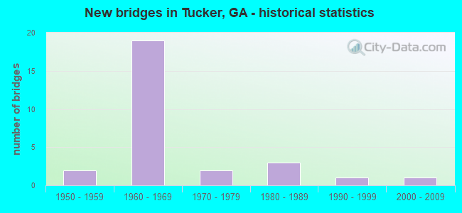
- New bridges - historical statistics
- 21950-1959
- 191960-1969
- 21970-1979
- 31980-1989
- 11990-1999
- 12000-2009
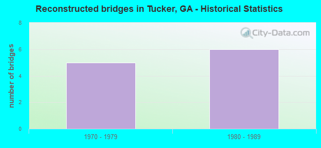
- Reconstructed bridges - Historical Statistics
- 51970-1979
- 61980-1989
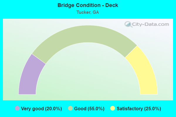
- Bridge Condition - Deck
- 20.0%Very good
- 55.0%Good
- 25.0%Satisfactory
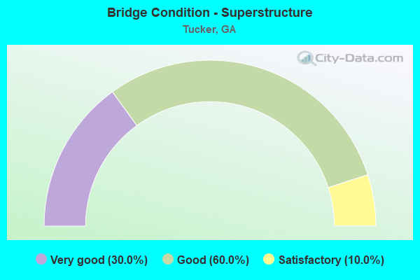
- Bridge Condition - Superstructure
- 30.0%Very good
- 60.0%Good
- 10.0%Satisfactory
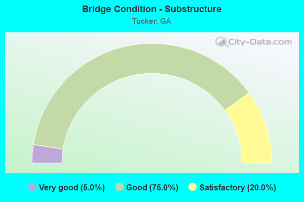
- Bridge Condition - Substructure
- 5.0%Very good
- 75.0%Good
- 20.0%Satisfactory
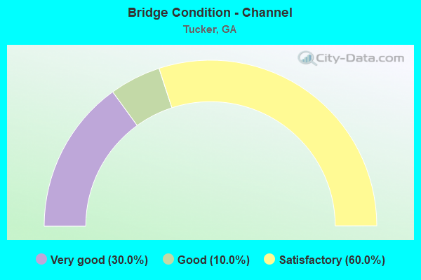
- Bridge Condition - Channel
- 30.0%Very good
- 10.0%Good
- 60.0%Satisfactory
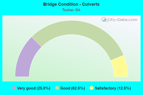
- Bridge Condition - Culverts
- 25.0%Very good
- 62.5%Good
- 12.5%Satisfactory
Find on map >> Show street view
Structure Number: 890006, Location: 3.5 MI NE OF CLARKSTON (Lat: 33.853608, Lng: -84.209819), Route carried "on" structure: US 29, Year Built: 1955, Year Reconstructed: 1983, Status: Open, Structure Length: 4.30m (14.11ft), Average Daily Traffic: 19,670 (year 2011), Truck Traffic: 1%, Average Future Daily Traffic: 29,505 (year 2031), Design Load: HS 20+Mod, Features Intersected: CSX RAILROAD, Facility Carried by Structure: LAWRENCEVILLE HWY.
Minimum Vertical Clearance: 30+ m (98+ ft), Kilometerpoint: 17.703, Lanes on structure: 4, Base Highway Network: Yes, Owner: State Highway Agency, Approaching Roadway Width: 20.1m (65.9ft), Skew: 3 degrees, Material/Design: Steel, Design/Construction: Stringer/Multi-beam, Number Of Spans In Main Unit: 3, Length of Maximum Span: 14.3m (46.9ft), Curb or Sidewalk Widths: Left: 1.8m (5.9ft), Right: 1.8m (5.9ft), Curb-To-Curb Width: 20.1m (65.9ft), Out-to-Out Width: 24.5m (80.4ft)
Condition: Deck: Very good, Superstructure: Very good, Substructure: Good, Operating Rating: 53.5 metric tons, Method Used To Determine Operating Rating: Load Factor (LF), Inventory Rating: 31.7 metric tons, Method Used To Determine Inventory Rating: Load Factor (LF), Structural Evaluation: Better than present minimum criteria, Deck Geometry: Better than present minimum criteria, Underclear: Somewhat better than minimum adequacy, Approach Roadway Alignment: Equal to present desirable criteria, Designated Inspection Frequency: Every 24 months, Inspection Date: June 2020, Bridge Improvement Cost: $851,000, Roadway Improvement Cost: $85,000, Total Project Cost: $1,277,000, Deck Structure Type: Concrete Cast-file-Place, Wearing Surface/Protective System: Wearing Surface: Bituminous, Membrane: Built-up
Find on map >> Show street view
Structure Number: 890048, Location: 3.6 MI N OF CLARKSTON (Lat: 33.846425, Lng: -84.247192), Route carried "on" structure: State highway 236, Year Built: 1968, Status: Open, Structure Length: 6.46m (21.19ft), Average Daily Traffic: 22,780 (year 2011), Truck Traffic: 2%, Average Future Daily Traffic: 34,170 (year 2031), Design Load: HS 20+Mod, Features Intersected: I-285 (SR 407), Facility Carried by Structure: LAVISTA ROAD
Minimum Vertical Clearance: 30+ m (98+ ft), Kilometerpoint: 11.265, Lanes on structure: 6, Lanes under structure: 8, Base Highway Network: Yes, Owner: State Highway Agency, Approaching Roadway Width: 12.2m (40.0ft), Skew: 11 degrees, Material/Design: Steel, Design/Construction: Stringer/Multi-beam, Number Of Spans In Main Unit: 4, Length of Maximum Span: 21.3m (69.9ft), Curb or Sidewalk Widths: Left: 1.2m (3.9ft), Right: 1.2m (3.9ft), Curb-To-Curb Width: 24.4m (80.1ft), Out-to-Out Width: 28.3m (92.8ft)
Condition: Deck: Satisfactory, Superstructure: Good, Substructure: Satisfactory, Operating Rating: 36.2 metric tons, Method Used To Determine Operating Rating: Load Factor (LF), Inventory Rating: 21.7 metric tons, Method Used To Determine Inventory Rating: Load Factor (LF), Structural Evaluation: Somewhat better than minimum adequacy, Deck Geometry: Somewhat better than minimum adequacy, Underclear: Meets minimum limits, Approach Roadway Alignment: Equal to present desirable criteria, Designated Inspection Frequency: Every 24 months, Inspection Date: August 2020, Bridge Improvement Cost: $1,732,000, Roadway Improvement Cost: $173,000, Total Project Cost: $2,598,000, Deck Structure Type: Concrete Cast-file-Place
Find on map >> Show street view
Structure Number: 890079, Location: 3.3 MI S OF CHAMBLEE (Lat: 33.878614, Lng: -84.249728), Route carried "on" structure: Interstate 285, Year Built: 1968, Year Reconstructed: 1980, Status: Open, Structure Length: 4.88m (16.01ft), Average Daily Traffic: 198,060 (year 2011), Truck Traffic: 9%, Average Future Daily Traffic: 297,090 (year 2031), Design Load: HS 20+Mod, Features Intersected: M-9276 HENDERSON MILL RD
Minimum Vertical Clearance: 30+ m (98+ ft), Kilometerpoint: 54.718, Lanes on structure: 10, Lanes under structure: 2, Base Highway Network: Yes, Owner: State Highway Agency, Approaching Roadway Width: 46.0m (150.9ft), Skew: 33 degrees, Material/Design: Steel continuous, Design/Construction: Stringer/Multi-beam, Number Of Spans In Main Unit: 3, Length of Maximum Span: 21.6m (70.9ft), Curb-To-Curb Width: 45.9m (150.6ft), Out-to-Out Width: 52.6m (172.6ft)
Condition: Deck: Good, Superstructure: Very good, Substructure: Good, Operating Rating: 31.7 metric tons, Method Used To Determine Operating Rating: Load Factor (LF), Inventory Rating: 19.0 metric tons, Method Used To Determine Inventory Rating: Load Factor (LF), Structural Evaluation: Meets minimum limits, Deck Geometry: Superior to present desirable criteria, Underclear: Meets minimum limits, Approach Roadway Alignment: Equal to present desirable criteria, Designated Inspection Frequency: Every 24 months, Inspection Date: July 2020, Bridge Improvement Cost: $1,989,000, Roadway Improvement Cost: $199,000, Total Project Cost: $2,984,000, Deck Structure Type: Concrete Cast-file-Place, Wearing Surface/Protective System: Wearing Surface: Epoxy Overlay
Find on map >> Show street view
Structure Number: 89008, Location: 4.1 MI SE OF CHAMBLEE (Lat: 33.872111, Lng: -84.249728), Route carried "on" structure: Interstate 285, Year Built: 1968, Year Reconstructed: 1980, Status: Open, Structure Length: 4.79m (15.72ft), Average Daily Traffic: 198,060 (year 2011), Truck Traffic: 9%, Average Future Daily Traffic: 297,090 (year 2031), Design Load: HS 20+Mod, Features Intersected: M-9279 EVANS ROAD
Minimum Vertical Clearance: 30+ m (98+ ft), Kilometerpoint: 54.718, Lanes on structure: 8, Lanes under structure: 2, Base Highway Network: Yes, Owner: State Highway Agency, Approaching Roadway Width: 39.0m (128.0ft), Skew: 31 degrees, Material/Design: Steel continuous, Design/Construction: Stringer/Multi-beam, Number Of Spans In Main Unit: 3, Length of Maximum Span: 20.1m (65.9ft), Curb-To-Curb Width: 40.2m (131.9ft), Out-to-Out Width: 41.0m (134.5ft)
Condition: Deck: Good, Superstructure: Very good, Substructure: Good, Operating Rating: 37.1 metric tons, Method Used To Determine Operating Rating: Load Factor (LF), Inventory Rating: 21.7 metric tons, Method Used To Determine Inventory Rating: Load Factor (LF), Structural Evaluation: Somewhat better than minimum adequacy, Deck Geometry: Superior to present desirable criteria, Underclear: Superior to present desirable criteria, Approach Roadway Alignment: Equal to present desirable criteria, Designated Inspection Frequency: Every 24 months, Inspection Date: July 2020, Bridge Improvement Cost: $1,617,000, Roadway Improvement Cost: $162,000, Total Project Cost: $2,426,000, Deck Structure Type: Concrete Cast-file-Place, Wearing Surface/Protective System: Wearing Surface: Epoxy Overlay
Find on map >> Show street view
Structure Number: 890081, Location: 3.2 MI SE OF CHAMBLEE (Lat: 33.870389, Lng: -84.249750), Route carried "on" structure: Interstate 285, Year Built: 1968, Status: Open, Structure Length: 1.46m (4.79ft), Average Daily Traffic: 198,060 (year 2011), Truck Traffic: 9%, Average Future Daily Traffic: 297,090 (year 2031), Design Load: HS 20+Mod, Features Intersected: HENDERSON MILL CREEK TRB
Minimum Vertical Clearance: 30+ m (98+ ft), Kilometerpoint: 54.718, Lanes on structure: 8, Base Highway Network: Yes, Owner: State Highway Agency, Approaching Roadway Width: 39.0m (128.0ft), Skew: 35 degrees, Material/Design: Concrete, Design/Construction: Culvert, Number Of Spans In Main Unit: 3, Length of Maximum Span: 4.6m (15.1ft)
Condition: Channel: Very good, Culverts: Satisfactory, Structural Evaluation: Equal to present minimum criteria, Waterway Adequacy: Equal to present desirable criteria, Approach Roadway Alignment: Equal to present desirable criteria, Designated Inspection Frequency: Every 24 months, Inspection Date: July 2020, Bridge Improvement Cost: $494,000, Roadway Improvement Cost: $49,000, Total Project Cost: $742,000
Find on map >> Show street view
Structure Number: 890082, Location: 3.7 MI SE OF CHAMBLEE (Lat: 33.861125, Lng: -84.247853), Route carried "on" structure: Interstate 285, Year Built: 1968, Year Reconstructed: 1980, Status: Open, Structure Length: 4.30m (14.11ft), Average Daily Traffic: 198,060 (year 2011), Truck Traffic: 9%, Average Future Daily Traffic: 297,090 (year 2031), Design Load: HS 20+Mod, Features Intersected: M-9281 MIDVALE ROAD
Minimum Vertical Clearance: 30+ m (98+ ft), Kilometerpoint: 56.327, Lanes on structure: 8, Lanes under structure: 2, Base Highway Network: Yes, Owner: State Highway Agency, Approaching Roadway Width: 39.0m (128.0ft), Skew: 31 degrees, Material/Design: Steel continuous, Design/Construction: Stringer/Multi-beam, Number Of Spans In Main Unit: 3, Length of Maximum Span: 19.5m (64.0ft), Curb-To-Curb Width: 40.1m (131.6ft), Out-to-Out Width: 40.8m (133.9ft)
Condition: Deck: Good, Superstructure: Very good, Substructure: Good, Operating Rating: 42.6 metric tons, Method Used To Determine Operating Rating: Load Factor (LF), Inventory Rating: 25.4 metric tons, Method Used To Determine Inventory Rating: Load Factor (LF), Structural Evaluation: Equal to present minimum criteria, Deck Geometry: Superior to present desirable criteria, Underclear: Superior to present desirable criteria, Approach Roadway Alignment: Equal to present desirable criteria, Designated Inspection Frequency: Every 24 months, Inspection Date: July 2020, Bridge Improvement Cost: $1,452,000, Roadway Improvement Cost: $145,000, Total Project Cost: $2,179,000, Deck Structure Type: Concrete Cast-file-Place, Wearing Surface/Protective System: Wearing Surface: Epoxy Overlay
Find on map >> Show street view
Structure Number: 890083, Location: 2.1 MI N OF CLARKSTON (Lat: 33.838886, Lng: -84.248236), Route carried "on" structure: Interstate 285, Year Built: 1968, Year Reconstructed: 1985, Status: Open, Structure Length: 8.66m (28.41ft), Average Daily Traffic: 194,070 (year 2011), Truck Traffic: 1%, Average Future Daily Traffic: 291,105 (year 2031), Design Load: HS 20+Mod, Features Intersected: CSX RR- BURNT CREEK
Minimum Vertical Clearance: 30+ m (98+ ft), Kilometerpoint: 59.546, Lanes on structure: 9, Base Highway Network: Yes, Owner: State Highway Agency, Approaching Roadway Width: 42.7m (140.1ft), Skew: 32 degrees, Material/Design: Steel, Design/Construction: Stringer/Multi-beam, Number Of Spans In Main Unit: 4, Length of Maximum Span: 24.1m (79.1ft), Curb-To-Curb Width: 44.3m (145.3ft), Out-to-Out Width: 46.1m (151.2ft)
Condition: Deck: Good, Superstructure: Good, Substructure: Good, Channel: Satisfactory, Operating Rating: 31.7 metric tons, Method Used To Determine Operating Rating: Load Factor (LF), Inventory Rating: 19.0 metric tons, Method Used To Determine Inventory Rating: Load Factor (LF), Structural Evaluation: Meets minimum limits, Deck Geometry: Superior to present desirable criteria, Underclear: Equal to present minimum criteria, Waterway Adequacy: Superior to present desirable criteria, Approach Roadway Alignment: Equal to present desirable criteria, Designated Inspection Frequency: Every 24 months, Inspection Date: August 2020, Bridge Improvement Cost: $3,228,000, Roadway Improvement Cost: $323,000, Total Project Cost: $4,842,000, Deck Structure Type: Concrete Cast-file-Place, Wearing Surface/Protective System: Wearing Surface: Epoxy Overlay
Find on map >> Show street view
Structure Number: 890084, Location: 0.8 MI NW OF CLARKSTON (Lat: 33.818117, Lng: -84.251061), Route carried "on" structure: Interstate 285, Year Built: 1968, Year Reconstructed: 1981, Status: Open, Structure Length: 3.81m (12.50ft), Average Daily Traffic: 187,550 (year 2011), Truck Traffic: 1%, Average Future Daily Traffic: 281,325 (year 2031), Design Load: HS 20+Mod, Features Intersected: SR 410 RMP TO I-285 CBL
Minimum Vertical Clearance: 30+ m (98+ ft), Kilometerpoint: 61.155, Lanes on structure: 5, Lanes under structure: 1, Base Highway Network: Yes, Owner: State Highway Agency, Approaching Roadway Width: 26.8m (87.9ft), Skew: 10 degrees, Material/Design: Steel, Design/Construction: Stringer/Multi-beam, Number Of Spans In Main Unit: 3, Length of Maximum Span: 14.9m (48.9ft), Curb-To-Curb Width: 32.3m (106.0ft), Out-to-Out Width: 33.3m (109.3ft)
Condition: Deck: Satisfactory, Superstructure: Good, Substructure: Satisfactory, Operating Rating: 37.1 metric tons, Method Used To Determine Operating Rating: Load Factor (LF), Inventory Rating: 21.7 metric tons, Method Used To Determine Inventory Rating: Load Factor (LF), Structural Evaluation: Somewhat better than minimum adequacy, Deck Geometry: Superior to present desirable criteria, Underclear: Better than present minimum criteria, Approach Roadway Alignment: Equal to present desirable criteria, Designated Inspection Frequency: Every 24 months, Inspection Date: June 2020, Bridge Improvement Cost: $888,000, Roadway Improvement Cost: $89,000, Total Project Cost: $1,332,000, Deck Structure Type: Concrete Cast-file-Place, Wearing Surface/Protective System: Wearing Surface: Epoxy Overlay
Find on map >> Show street view
Structure Number: 890111, Location: 1.2 MI N OF CLARKSTON (Lat: 33.825097, Lng: -84.233419), Route carried "on" structure: US 78, Year Built: 1967, Year Reconstructed: 1985, Status: Open, Structure Length: 4.75m (15.58ft), Average Daily Traffic: 100,620 (year 2011), Truck Traffic: 1%, Average Future Daily Traffic: 150,930 (year 2031), Design Load: HS 20+Mod, Features Intersected: SR 859 BROCKETT ROAD
Minimum Vertical Clearance: 30+ m (98+ ft), Kilometerpoint: 12.875, Lanes on structure: 6, Lanes under structure: 6, Base Highway Network: Yes, Owner: State Highway Agency, Approaching Roadway Width: 30.5m (100.1ft), Skew: 30 degrees, Material/Design: Steel, Design/Construction: Stringer/Multi-beam, Number Of Spans In Main Unit: 3, Length of Maximum Span: 22.9m (75.1ft), Curb-To-Curb Width: 39.5m (129.6ft), Out-to-Out Width: 41.0m (134.5ft)
Condition: Deck: Satisfactory, Superstructure: Good, Substructure: Good, Operating Rating: 31.7 metric tons, Method Used To Determine Operating Rating: Load Factor (LF), Inventory Rating: 19.0 metric tons, Method Used To Determine Inventory Rating: Load Factor (LF), Structural Evaluation: Meets minimum limits, Deck Geometry: Superior to present desirable criteria, Underclear: High priority of corrective action, Approach Roadway Alignment: Equal to present desirable criteria, Designated Inspection Frequency: Every 24 months, Inspection Date: June 2020, Bridge Improvement Cost: $1,274,000, Roadway Improvement Cost: $127,000, Total Project Cost: $1,912,000, Deck Structure Type: Concrete Cast-file-Place
Find on map >> Show street view
Structure Number: 890131, Location: 3.7 MI NW OF STONE MTN (Lat: 33.855758, Lng: -84.200108), Route carried "on" structure: County highway 5164, Year Built: 1977, Status: Open, Structure Length: 11.13m (36.52ft), Average Daily Traffic: 23,340 (year 2011), Truck Traffic: 1%, Average Future Daily Traffic: 35,010 (year 2031), Design Load: HS 20+Mod, Features Intersected: CSX RAILROAD, Facility Carried by Structure: MOUNTAIN IND BLVD
Minimum Vertical Clearance: 30+ m (98+ ft), Kilometerpoint: 0.000, Lanes on structure: 4, Base Highway Network: Yes, Owner: County Highway Agency, Approaching Roadway Width: 15.8m (51.8ft), Skew: 3 degrees, Material/Design: Steel, Design/Construction: Stringer/Multi-beam, Number Of Spans In Main Unit: 5, Length of Maximum Span: 29.0m (95.1ft), Curb or Sidewalk Widths: Left: 1.2m (3.9ft), Right: 1.2m (3.9ft), Curb-To-Curb Width: 15.9m (52.2ft), Out-to-Out Width: 19.0m (62.3ft)
Condition: Deck: Good, Superstructure: Good, Substructure: Good, Operating Rating: 61.6 metric tons, Method Used To Determine Operating Rating: Load Factor (LF), Inventory Rating: 37.1 metric tons, Method Used To Determine Inventory Rating: Load Factor (LF), Structural Evaluation: Better than present minimum criteria, Deck Geometry: Meets minimum limits, Underclear: Better than present minimum criteria, Approach Roadway Alignment: Better than present minimum criteria, Designated Inspection Frequency: Every 24 months, Inspection Date: June 2020, Bridge Improvement Cost: $2,204,000, Roadway Improvement Cost: $220,000, Total Project Cost: $3,306,000, Deck Structure Type: Concrete Cast-file-Place
Find on map >> Show street view
Structure Number: 890132, Location: 2.6 MI NW OF STONE MTN (Lat: 33.835000, Lng: -84.200228), Route carried "on" structure: County highway 5184, Year Built: 1967, Year Reconstructed: 1986, Status: Open, Structure Length: 8.14m (26.71ft), Average Daily Traffic: 22,560 (year 2011), Truck Traffic: 1%, Average Future Daily Traffic: 33,840 (year 2031), Design Load: HS 20+Mod, Features Intersected: SR 410 STONE MTN FREEWAY, Facility Carried by Structure: MOUNTAIN IND. BLVD
Minimum Vertical Clearance: 30+ m (98+ ft), Kilometerpoint: 0.000, Lanes on structure: 6, Lanes under structure: 6, Base Highway Network: Yes, Owner: State Highway Agency, Approaching Roadway Width: 23.8m (78.1ft), Skew: 2 degrees, Material/Design: Steel, Design/Construction: Stringer/Multi-beam, Number Of Spans In Main Unit: 4, Length of Maximum Span: 22.3m (73.2ft), Curb or Sidewalk Widths: Left: 0.0m, Right: 0.6m (2.0ft), Curb-To-Curb Width: 23.9m (78.4ft), Out-to-Out Width: 25.4m (83.3ft)
Condition: Deck: Satisfactory, Superstructure: Good, Substructure: Satisfactory, Operating Rating: 37.1 metric tons, Method Used To Determine Operating Rating: Load Factor (LF), Inventory Rating: 21.7 metric tons, Method Used To Determine Inventory Rating: Load Factor (LF), Structural Evaluation: Somewhat better than minimum adequacy, Deck Geometry: Somewhat better than minimum adequacy, Underclear: Somewhat better than minimum adequacy, Approach Roadway Alignment: Equal to present desirable criteria, Designated Inspection Frequency: Every 24 months, Other Special Inspection Frequency: Every 24 months, Inspection Date: July 2020, Other Special Inspection Date: January 2021, Bridge Improvement Cost: $2,181,000, Roadway Improvement Cost: $218,000, Total Project Cost: $3,272,000, Deck Structure Type: Concrete Cast-file-Place
Find on map >> Show street view
Structure Number: 890144, Location: 2 MI NW OF STONE MTN (Lat: 33.825406, Lng: -84.195836), Route carried "on" structure: County highway 5191, Year Built: 1963, Year Reconstructed: 1982, Status: Posted for load, Structure Length: 3.51m (11.52ft), Average Daily Traffic: 20,970 (year 2011), Truck Traffic: 1%, Average Future Daily Traffic: 31,455 (year 2031), Design Load: H 15, Features Intersected: CSX RAILROAD, Facility Carried by Structure: HAIRSTON ROAD
Minimum Vertical Clearance: 30+ m (98+ ft), Kilometerpoint: 0.000, Lanes on structure: 5, Base Highway Network: Yes, Owner: County Highway Agency, Approaching Roadway Width: 17.1m (56.1ft), Skew: 11 degrees, Material/Design: Steel, Design/Construction: Stringer/Multi-beam, Number Of Spans In Main Unit: 3, Length of Maximum Span: 12.5m (41.0ft), Curb or Sidewalk Widths: Left: 1.8m (5.9ft), Right: 1.8m (5.9ft), Curb-To-Curb Width: 20.8m (68.2ft), Out-to-Out Width: 26.3m (86.3ft)
Condition: Deck: Very good, Superstructure: Satisfactory, Substructure: Good, Operating Rating: 27.2 metric tons, Method Used To Determine Operating Rating: Load Factor (LF), Inventory Rating: 16.3 metric tons, Method Used To Determine Inventory Rating: Load Factor (LF), Structural Evaluation: Meets minimum limits, Deck Geometry: Somewhat better than minimum adequacy, Underclear: Meets minimum limits, Approach Roadway Alignment: Equal to present desirable criteria, Bridge Posting: Required (Relationship of Operating Rating to Maximum Legal Load: 10.0 - 19.9% below), Designated Inspection Frequency: Every 24 months, Inspection Date: June 2020, Bridge Improvement Cost: $817,000, Roadway Improvement Cost: $82,000, Total Project Cost: $1,225,000, Deck Structure Type: Concrete Cast-file-Place, Wearing Surface/Protective System: Wearing Surface: Bituminous
Find on map >> Show street view
Structure Number: 890179, Location: 2.2 MI N OF CLARKSTON (Lat: 33.841533, Lng: -84.242528), Route carried "on" structure: City street 9223, Year Built: 1968, Year Reconstructed: 1984, Status: Open, Structure Length: 4.85m (15.91ft), Average Daily Traffic: 18,150 (year 2011), Truck Traffic: 1%, Average Future Daily Traffic: 27,225 (year 2031), Design Load: HS 20+Mod, Features Intersected: CSX RAILROAD, Facility Carried by Structure: NORTHLAKE PARKWAY
Minimum Vertical Clearance: 30+ m (98+ ft), Kilometerpoint: 3.219, Lanes on structure: 4, Base Highway Network: Yes, Owner: County Highway Agency, Approaching Roadway Width: 17.1m (56.1ft), Skew: 10 degrees, Material/Design: Steel, Design/Construction: Stringer/Multi-beam, Number Of Spans In Main Unit: 3, Length of Maximum Span: 17.1m (56.1ft), Curb or Sidewalk Widths: Left: 1.8m (5.9ft), Right: 1.8m (5.9ft), Curb-To-Curb Width: 21.9m (71.9ft), Out-to-Out Width: 26.4m (86.6ft)
Condition: Deck: Good, Superstructure: Satisfactory, Substructure: Satisfactory, Operating Rating: 45.3 metric tons, Method Used To Determine Operating Rating: Allowable Stress (AS), Inventory Rating: 27.2 metric tons, Method Used To Determine Inventory Rating: Allowable Stress (AS), Structural Evaluation: Equal to present minimum criteria, Deck Geometry: Superior to present desirable criteria, Underclear: Equal to present minimum criteria, Approach Roadway Alignment: Equal to present desirable criteria, Designated Inspection Frequency: Every 24 months, Inspection Date: July 2020, Bridge Improvement Cost: $960,000, Roadway Improvement Cost: $96,000, Total Project Cost: $1,440,000, Deck Structure Type: Concrete Cast-file-Place
Find on map >> Show street view
Structure Number: 89018, Location: 2.9 MI N OF CLARKSTON (Lat: 33.851186, Lng: -84.246617), Route carried "on" structure: City street 9223, Year Built: 1968, Year Reconstructed: 1984, Status: Open, Structure Length: 6.46m (21.19ft), Average Daily Traffic: 10,710 (year 2011), Truck Traffic: 1%, Average Future Daily Traffic: 16,065 (year 2031), Design Load: HS 20+Mod, Features Intersected: I-285 (SR 407), Facility Carried by Structure: NORTHLAKE PARKWAY
Minimum Vertical Clearance: 30+ m (98+ ft), Kilometerpoint: 3.219, Lanes on structure: 4, Lanes under structure: 8, Base Highway Network: Yes, Owner: State Highway Agency, Approaching Roadway Width: 20.1m (65.9ft), Material/Design: Steel, Design/Construction: Stringer/Multi-beam, Number Of Spans In Main Unit: 4, Length of Maximum Span: 23.2m (76.1ft), Curb or Sidewalk Widths: Left: 1.2m (3.9ft), Right: 1.8m (5.9ft), Curb-To-Curb Width: 20.1m (65.9ft), Out-to-Out Width: 24.0m (78.7ft)
Condition: Deck: Good, Superstructure: Good, Substructure: Good, Operating Rating: 36.2 metric tons, Method Used To Determine Operating Rating: Load Factor (LF), Inventory Rating: 21.7 metric tons, Method Used To Determine Inventory Rating: Load Factor (LF), Structural Evaluation: Somewhat better than minimum adequacy, Deck Geometry: Better than present minimum criteria, Underclear: Meets minimum limits, Approach Roadway Alignment: Equal to present desirable criteria, Designated Inspection Frequency: Every 24 months, Inspection Date: July 2020, Bridge Improvement Cost: $1,280,000, Roadway Improvement Cost: $128,000, Total Project Cost: $1,920,000, Deck Structure Type: Concrete Cast-file-Place
Find on map >> Show street view
Structure Number: 890199, Location: 2 MI S OF DORAVILLE (Lat: 33.885508, Lng: -84.251789), Route carried "on" structure: City street 9265, Year Built: 1981, Status: Open, Structure Length: 7.01m (23.00ft), Average Daily Traffic: 13,070 (year 2011), Truck Traffic: 1%, Average Future Daily Traffic: 19,605 (year 2031), Design Load: HS 20+Mod, Features Intersected: I-285 (SR 407), Facility Carried by Structure: CHAMBLEE-TUCKER RD
Minimum Vertical Clearance: 30+ m (98+ ft), Kilometerpoint: 6.437, Lanes on structure: 6, Lanes under structure: 8, Base Highway Network: Yes, Owner: State Highway Agency, Approaching Roadway Width: 24.4m (80.1ft), Skew: 23 degrees, Material/Design: Steel continuous, Design/Construction: Stringer/Multi-beam, Number Of Spans In Main Unit: 2, Length of Maximum Span: 41.8m (137.1ft), Curb or Sidewalk Widths: Left: 1.8m (5.9ft), Right: 1.8m (5.9ft), Curb-To-Curb Width: 24.4m (80.1ft), Out-to-Out Width: 28.8m (94.5ft)
Condition: Deck: Very good, Superstructure: Good, Substructure: Good, Operating Rating: 38.1 metric tons, Method Used To Determine Operating Rating: Load Factor (LF), Inventory Rating: 22.6 metric tons, Method Used To Determine Inventory Rating: Load Factor (LF), Structural Evaluation: Somewhat better than minimum adequacy, Deck Geometry: Somewhat better than minimum adequacy, Underclear: High priority of corrective action, Approach Roadway Alignment: Equal to present desirable criteria, Designated Inspection Frequency: Every 24 months, Inspection Date: July 2020, Bridge Improvement Cost: $1,879,000, Roadway Improvement Cost: $188,000, Total Project Cost: $2,819,000, Deck Structure Type: Concrete Cast-file-Place, Wearing Surface/Protective System: Deck Protection: Epoxy Coated Reinforcing
Find on map >> Show street view
Structure Number: 8902, Location: 2 MI SE OF DORAVILLE (Lat: 33.885550, Lng: -84.250808), Route carried "on" structure: City street 9265, Year Built: 1980, Status: Open, Structure Length: 2.38m (7.81ft), Average Daily Traffic: 21,400 (year 2011), Truck Traffic: 1%, Average Future Daily Traffic: 32,100 (year 2031), Design Load: HS 20+Mod, Features Intersected: I-285 RAMP (SR 407), Facility Carried by Structure: CHAMBLEE-TUCKER RD
Minimum Vertical Clearance: 30+ m (98+ ft), Kilometerpoint: 6.437, Lanes on structure: 6, Lanes under structure: 2, Base Highway Network: Yes, Owner: State Highway Agency, Approaching Roadway Width: 44.2m (145.0ft), Skew: 23 degrees, Material/Design: Steel, Design/Construction: Stringer/Multi-beam, Number Of Spans In Main Unit: 1, Length of Maximum Span: 23.8m (78.1ft), Curb or Sidewalk Widths: Left: 1.8m (5.9ft), Right: 1.8m (5.9ft), Curb-To-Curb Width: 24.4m (80.1ft), Out-to-Out Width: 28.8m (94.5ft)
Condition: Deck: Very good, Superstructure: Very good, Substructure: Good, Operating Rating: 89.8 metric tons, Method Used To Determine Operating Rating: Allowable Stress (AS), Inventory Rating: 59.8 metric tons, Method Used To Determine Inventory Rating: Allowable Stress (AS), Structural Evaluation: Better than present minimum criteria, Deck Geometry: Somewhat better than minimum adequacy, Underclear: Superior to present desirable criteria, Approach Roadway Alignment: Equal to present desirable criteria, Designated Inspection Frequency: Every 24 months, Inspection Date: July 2020, Bridge Improvement Cost: $637,000, Roadway Improvement Cost: $64,000, Total Project Cost: $956,000, Deck Structure Type: Concrete Cast-file-Place, Wearing Surface/Protective System: Deck Protection: Epoxy Coated Reinforcing
Find on map >> Show street view
Structure Number: 890211, Location: 3.3 MI SE OF CHAMBLEE (Lat: 33.870992, Lng: -84.250561), Route carried "on" structure: City street 9276, Year Built: 1950, Status: Open, Structure Length: 1.10m (3.61ft), Average Daily Traffic: 9,590 (year 2011), Truck Traffic: 1%, Average Future Daily Traffic: 14,385 (year 2031), Design Load: HS 20+Mod, Features Intersected: HENDERSON MILL CREEK TRB, Facility Carried by Structure: HENDERSON MILL RD.
Minimum Vertical Clearance: 30+ m (98+ ft), Kilometerpoint: 1.609, Lanes on structure: 2, Base Highway Network: Yes, Owner: County Highway Agency, Approaching Roadway Width: 9.1m (29.9ft), Skew: 4 degrees, Material/Design: Concrete, Design/Construction: Culvert, Number Of Spans In Main Unit: 3, Length of Maximum Span: 3.4m (11.2ft), Curb or Sidewalk Widths: Left: 1.2m (3.9ft), Right: 0.0m
Condition: Channel: Satisfactory, Culverts: Good, Operating Rating: 55.3 metric tons, Method Used To Determine Operating Rating: Field evaluation and documented engineering judgment, Inventory Rating: 32.6 metric tons, Method Used To Determine Inventory Rating: Field evaluation and documented engineering judgment, Structural Evaluation: Better than present minimum criteria, Waterway Adequacy: Equal to present minimum criteria, Approach Roadway Alignment: Equal to present desirable criteria, Designated Inspection Frequency: Every 24 months, Inspection Date: July 2020, Bridge Improvement Cost: $141,000, Roadway Improvement Cost: $14,000, Total Project Cost: $211,000
Find on map >> Show street view
Structure Number: 890213, Location: 3.3 MI SE OF CHAMBLEE (Lat: 33.867789, Lng: -84.249394), Route carried "on" structure: City street 9280, Year Built: 1968, Status: Open, Structure Length: 7.28m (23.88ft), Average Daily Traffic: 4,550 (year 2011), Truck Traffic: 1%, Average Future Daily Traffic: 6,825 (year 2031), Design Load: HS 20+Mod, Features Intersected: I-285 (SR 407), Facility Carried by Structure: HENDERSON ROAD
Minimum Vertical Clearance: 30+ m (98+ ft), Kilometerpoint: 0.000, Lanes on structure: 2, Lanes under structure: 8, Base Highway Network: Yes, Owner: State Highway Agency, Approaching Roadway Width: 9.1m (29.9ft), Material/Design: Steel continuous, Design/Construction: Stringer/Multi-beam, Number Of Spans In Main Unit: 4, Length of Maximum Span: 21.6m (70.9ft), Curb or Sidewalk Widths: Left: 1.2m (3.9ft), Right: 1.2m (3.9ft), Curb-To-Curb Width: 9.1m (29.9ft), Out-to-Out Width: 12.4m (40.7ft)
Condition: Deck: Satisfactory, Superstructure: Good, Substructure: Good, Operating Rating: 56.2 metric tons, Method Used To Determine Operating Rating: Load Factor (LF), Inventory Rating: 33.5 metric tons, Method Used To Determine Inventory Rating: Load Factor (LF), Structural Evaluation: Better than present minimum criteria, Deck Geometry: Meets minimum limits, Underclear: Somewhat better than minimum adequacy, Approach Roadway Alignment: Better than present minimum criteria, Designated Inspection Frequency: Every 24 months, Inspection Date: July 2020, Bridge Improvement Cost: $934,000, Roadway Improvement Cost: $93,000, Total Project Cost: $1,401,000, Deck Structure Type: Concrete Cast-file-Place
Find on map >> Show street view
Structure Number: 890214, Location: 2.3 MI NE OF CLARKSTON (Lat: 33.834447, Lng: -84.213769), Route carried "on" structure: City street 9287, Year Built: 1967, Status: Open, Structure Length: 9.14m (29.99ft), Average Daily Traffic: 7,720 (year 2011), Truck Traffic: 1%, Average Future Daily Traffic: 11,580 (year 2031), Design Load: HS 20+Mod, Features Intersected: SR 410 STONE MTN FREEWAY, Facility Carried by Structure: IDLEWOOD ROAD
Minimum Vertical Clearance: 30+ m (98+ ft), Kilometerpoint: 1.609, Lanes on structure: 2, Lanes under structure: 6, Base Highway Network: Yes, Owner: State Highway Agency, Approaching Roadway Width: 6.7m (22.0ft), Skew: 3 degrees, Material/Design: Steel, Design/Construction: Stringer/Multi-beam, Number Of Spans In Main Unit: 4, Length of Maximum Span: 25.9m (85.0ft), Curb or Sidewalk Widths: Left: 0.6m (2.0ft), Right: 1.5m (4.9ft), Curb-To-Curb Width: 7.6m (24.9ft), Out-to-Out Width: 10.5m (34.4ft)
Condition: Deck: Good, Superstructure: Good, Substructure: Good, Operating Rating: 61.6 metric tons, Method Used To Determine Operating Rating: Load Factor (LF), Inventory Rating: 37.1 metric tons, Method Used To Determine Inventory Rating: Load Factor (LF), Structural Evaluation: Better than present minimum criteria, Deck Geometry: High priority of replacement, Underclear: High priority of corrective action, Approach Roadway Alignment: Equal to present desirable criteria, Length Of Structure Improvement: 15.73m (51.61ft), Designated Inspection Frequency: Every 24 months, Inspection Date: July 2020, Bridge Improvement Cost: $1,172,000, Roadway Improvement Cost: $117,000, Total Project Cost: $1,758,000, Deck Structure Type: Concrete Cast-file-Place
Find on map >> Show street view
Structure Number: 890323, Location: 0.8 MI NW OF CLARKSTON (Lat: 33.820628, Lng: -84.251658), Route carried "on" structure: US 78, Year Built: 1995, Status: Open, Structure Length: 1.40m (4.59ft), Average Daily Traffic: 17,370 (year 2011), Truck Traffic: 1%, Average Future Daily Traffic: 26,055 (year 2031), Design Load: HS 20+Mod, Features Intersected: I-285 RAMP, Facility Carried by Structure: SR 410R TO I-285
Minimum Vertical Clearance: 30+ m (98+ ft), Kilometerpoint: 11.265, Lanes on structure: 1, Lanes under structure: 1, Base Highway Network: Yes, Owner: State Highway Agency, Approaching Roadway Width: 14.0m (45.9ft), Skew: 4 degrees, Material/Design: Prestressed concrete, Design/Construction: Stringer/Multi-beam, Number Of Spans In Main Unit: 1, Length of Maximum Span: 14.0m (45.9ft), Curb-To-Curb Width: 13.7m (44.9ft), Out-to-Out Width: 97.8m (320.9ft)
Condition: Deck: Good, Superstructure: Very good, Substructure: Very good, Operating Rating: 46.2 metric tons, Method Used To Determine Operating Rating: Allowable Stress (AS), Inventory Rating: 32.6 metric tons, Method Used To Determine Inventory Rating: Allowable Stress (AS), Structural Evaluation: Equal to present desirable criteria, Deck Geometry: Superior to present desirable criteria, Underclear: Better than present minimum criteria, Approach Roadway Alignment: Equal to present desirable criteria, Designated Inspection Frequency: Every 24 months, Inspection Date: June 2020, Bridge Improvement Cost: $131,000, Roadway Improvement Cost: $13,000, Total Project Cost: $196,000, Deck Structure Type: Concrete Cast-file-Place
Find on map >> Show street view
Structure Number: 895032, Location: 7.1 MI SE OF DORAVILLE (Lat: 33.869239, Lng: -84.211728), Route carried "on" structure: County highway 1088, Year Built: 1968, Status: Open, Structure Length: 0.79m (2.59ft), Average Daily Traffic: 2,202 (year 2011), Truck Traffic: 1%, Average Future Daily Traffic: 3,303 (year 2031), Design Load: H 15, Features Intersected: LUCKY SHOALS CREEK, Facility Carried by Structure: ROTHERWOOD DRIVE
Minimum Vertical Clearance: 30+ m (98+ ft), Kilometerpoint: 1.609, Lanes on structure: 2, Base Highway Network: Yes, Owner: County Highway Agency, Approaching Roadway Width: 7.9m (25.9ft), Material/Design: Steel, Design/Construction: Culvert, Number Of Spans In Main Unit: 4, Length of Maximum Span: 1.5m (4.9ft)
Condition: Channel: Satisfactory, Culverts: Very good, Operating Rating: 41.7 metric tons, Method Used To Determine Operating Rating: Field evaluation and documented engineering judgment, Inventory Rating: 24.4 metric tons, Method Used To Determine Inventory Rating: Field evaluation and documented engineering judgment, Structural Evaluation: Equal to present minimum criteria, Waterway Adequacy: Equal to present minimum criteria, Approach Roadway Alignment: Meets minimum limits, Designated Inspection Frequency: Every 24 months, Inspection Date: July 2020, Bridge Improvement Cost: $102,000, Roadway Improvement Cost: $10,000, Total Project Cost: $152,000
Find on map >> Show street view
Structure Number: 895033, Location: 2.25 MI NW OF CLARKSTON (Lat: 33.834819, Lng: -84.255258), Route carried "on" structure: County highway 1127, Year Built: 1963, Status: Open, Structure Length: 0.64m (2.10ft), Average Daily Traffic: 2,202 (year 2011), Truck Traffic: 1%, Average Future Daily Traffic: 3,303 (year 2031), Design Load: H 15, Features Intersected: BURNT CREEK, Facility Carried by Structure: MONTREAL CIRCLE
Minimum Vertical Clearance: 30+ m (98+ ft), Kilometerpoint: 0.000, Lanes on structure: 2, Base Highway Network: Yes, Owner: County Highway Agency, Approaching Roadway Width: 8.5m (27.9ft), Material/Design: Concrete, Design/Construction: Culvert, Number Of Spans In Main Unit: 2, Length of Maximum Span: 3.0m (9.8ft), Curb or Sidewalk Widths: Left: 1.2m (3.9ft), Right: 1.2m (3.9ft), Curb-To-Curb Width: 8.5m (27.9ft), Out-to-Out Width: 12.4m (40.7ft)
Condition: Channel: Satisfactory, Culverts: Good, Operating Rating: 41.7 metric tons, Method Used To Determine Operating Rating: Field evaluation and documented engineering judgment, Inventory Rating: 24.4 metric tons, Method Used To Determine Inventory Rating: Field evaluation and documented engineering judgment, Structural Evaluation: Equal to present minimum criteria, Deck Geometry: Meets minimum limits, Waterway Adequacy: Equal to present minimum criteria, Approach Roadway Alignment: Equal to present minimum criteria, Designated Inspection Frequency: Every 24 months, Inspection Date: June 2020, Bridge Improvement Cost: $82,000, Roadway Improvement Cost: $8,000, Total Project Cost: $123,000, Deck Structure Type: Concrete Cast-file-Place
Find on map >> Show street view
Structure Number: 895067, Location: 4 MI NE OF CLARKSTON (Lat: 33.853308, Lng: -84.183197), Route carried "on" structure: County highway 3045, Year Built: 1968, Status: Open, Structure Length: 0.76m (2.49ft), Average Daily Traffic: 2,202 (year 2011), Truck Traffic: 1%, Average Future Daily Traffic: 3,303 (year 2031), Design Load: HS 20, Features Intersected: CAMP CREEK, Facility Carried by Structure: ANTEBELLUM DRIVE
Minimum Vertical Clearance: 30+ m (98+ ft), Kilometerpoint: 0.000, Lanes on structure: 2, Base Highway Network: Yes, Owner: County Highway Agency, Approaching Roadway Width: 7.9m (25.9ft), Material/Design: Steel, Design/Construction: Culvert, Number Of Spans In Main Unit: 3, Length of Maximum Span: 2.1m (6.9ft)
Condition: Channel: Satisfactory, Culverts: Very good, Operating Rating: 41.7 metric tons, Method Used To Determine Operating Rating: Field evaluation and documented engineering judgment, Inventory Rating: 24.4 metric tons, Method Used To Determine Inventory Rating: Field evaluation and documented engineering judgment, Structural Evaluation: Equal to present minimum criteria, Waterway Adequacy: Better than present minimum criteria, Approach Roadway Alignment: Better than present minimum criteria, Designated Inspection Frequency: Every 24 months, Inspection Date: June 2020, Bridge Improvement Cost: $98,000, Roadway Improvement Cost: $10,000, Total Project Cost: $147,000
Find on map >> Show street view
Structure Number: 895071, Location: 3.2 MI N OF CLARKSTON (Lat: 33.863239, Lng: -84.256469), Route carried "on" structure: County highway 3249, Year Built: 1962, Status: Open, Structure Length: 0.67m (2.20ft), Average Daily Traffic: 2,202 (year 2011), Truck Traffic: 1%, Average Future Daily Traffic: 3,303 (year 2031), Design Load: HS 20+Mod, Features Intersected: N FORK P'TREE CREEK TRIB, Facility Carried by Structure: HENDERSON CRK RD
Minimum Vertical Clearance: 30+ m (98+ ft), Kilometerpoint: 0.000, Lanes on structure: 2, Base Highway Network: Yes, Owner: County Highway Agency, Approaching Roadway Width: 7.3m (24.0ft), Skew: 1 degrees, Material/Design: Concrete, Design/Construction: Culvert, Number Of Spans In Main Unit: 2, Length of Maximum Span: 3.0m (9.8ft), Curb or Sidewalk Widths: Left: 1.2m (3.9ft), Right: 1.2m (3.9ft)
Condition: Channel: Good, Culverts: Good, Operating Rating: 55.3 metric tons, Method Used To Determine Operating Rating: Field evaluation and documented engineering judgment, Inventory Rating: 32.6 metric tons, Method Used To Determine Inventory Rating: Field evaluation and documented engineering judgment, Structural Evaluation: Better than present minimum criteria, Waterway Adequacy: High priority of replacement, Approach Roadway Alignment: Better than present minimum criteria, Designated Inspection Frequency: Every 24 months, Inspection Date: July 2020, Bridge Improvement Cost: $86,000, Roadway Improvement Cost: $9,000, Total Project Cost: $129,000
Find on map >> Show street view
Structure Number: 895093, Location: 2 MI N OF CLARKSTON (Lat: 33.830619, Lng: -84.225028), Route carried "on" structure: County highway 2200, Year Built: 1966, Status: Open, Structure Length: 0.67m (2.20ft), Average Daily Traffic: 2,202 (year 2011), Truck Traffic: 1%, Average Future Daily Traffic: 3,303 (year 2031), Design Load: H 15, Features Intersected: S FORK P'TREE CRK TRIB, Facility Carried by Structure: FRANKS DRIVE
Minimum Vertical Clearance: 30+ m (98+ ft), Kilometerpoint: 0.000, Lanes on structure: 2, Base Highway Network: Yes, Owner: County Highway Agency, Approaching Roadway Width: 7.9m (25.9ft), Material/Design: Steel, Design/Construction: Culvert, Number Of Spans In Main Unit: 3, Length of Maximum Span: 1.8m (5.9ft)
Condition: Channel: Very good, Culverts: Good, Operating Rating: 41.7 metric tons, Method Used To Determine Operating Rating: Field evaluation and documented engineering judgment, Inventory Rating: 24.4 metric tons, Method Used To Determine Inventory Rating: Field evaluation and documented engineering judgment, Structural Evaluation: Equal to present minimum criteria, Waterway Adequacy: Equal to present desirable criteria, Approach Roadway Alignment: Equal to present minimum criteria, Designated Inspection Frequency: Every 24 months, Inspection Date: June 2020, Bridge Improvement Cost: $86,000, Roadway Improvement Cost: $9,000, Total Project Cost: $129,000
Find on map >> Show street view
Structure Number: 895105, Location: 2 MI N OF CLARKSTON (Lat: 33.839458, Lng: -84.247489), Route carried "on" structure: County highway 6326, Year Built: 1986, Status: Open, Structure Length: 13.32m (43.70ft), Average Daily Traffic: 2,202 (year 2011), Truck Traffic: 1%, Average Future Daily Traffic: 3,303 (year 2031), Design Load: HS 20, Features Intersected: CSX RR - BURNT CREEK, Facility Carried by Structure: CRESENT CENTER BLD
Minimum Vertical Clearance: 30+ m (98+ ft), Kilometerpoint: 0.000, Lanes on structure: 4, Base Highway Network: Yes, Owner: County Highway Agency, Approaching Roadway Width: 15.5m (50.9ft), Skew: 3 degrees, Material/Design: Prestressed concrete, Design/Construction: Stringer/Multi-beam, Number Of Spans In Main Unit: 9, Length of Maximum Span: 27.1m (88.9ft), Curb or Sidewalk Widths: Left: 1.2m (3.9ft), Right: 0.0m, Curb-To-Curb Width: 16.2m (53.1ft), Out-to-Out Width: 18.3m (60.0ft)
Condition: Deck: Good, Superstructure: Good, Substructure: Good, Channel: Very good, Operating Rating: 54.4 metric tons, Method Used To Determine Operating Rating: Load Factor (LF), Inventory Rating: 32.6 metric tons, Method Used To Determine Inventory Rating: Load Factor (LF), Structural Evaluation: Better than present minimum criteria, Deck Geometry: Meets minimum limits, Underclear: Superior to present desirable criteria, Waterway Adequacy: Superior to present desirable criteria, Approach Roadway Alignment: Equal to present desirable criteria, Designated Inspection Frequency: Every 24 months, Inspection Date: August 2020, Bridge Improvement Cost: $2,639,000, Roadway Improvement Cost: $264,000, Total Project Cost: $3,958,000, Deck Structure Type: Concrete Precast Panels
Find on map >> Show street view
Structure Number: 895164, Location: 1.5 MI NW OF CLARKSTON (Lat: 33.827211, Lng: -84.252483), Route carried "on" structure: US 29, Year Built: 2007, Status: Open, Structure Length: 9.11m (29.89ft), Average Daily Traffic: 23,630 (year 2011), Truck Traffic: 1%, Average Future Daily Traffic: 35,445 (year 2031), Design Load: HS 20+Mod, Features Intersected: I-285 (SR 407)
Minimum Vertical Clearance: 30+ m (98+ ft), Kilometerpoint: 11.265, Lanes on structure: 8, Lanes under structure: 9, Base Highway Network: Yes, Owner: State Highway Agency, Approaching Roadway Width: 31.7m (104.0ft), Skew: 22 degrees, Material/Design: Prestressed concrete, Design/Construction: Stringer/Multi-beam, Number Of Spans In Main Unit: 2, Length of Maximum Span: 49.4m (162.1ft), Curb or Sidewalk Widths: Left: 1.8m (5.9ft), Right: 1.8m (5.9ft), Curb-To-Curb Width: 35.5m (116.5ft), Out-to-Out Width: 41.0m (134.5ft)
Condition: Deck: Good, Superstructure: Good, Substructure: Good, Operating Rating: 64.4 metric tons, Method Used To Determine Operating Rating: Allowable Stress (AS), Inventory Rating: 21.7 metric tons, Method Used To Determine Inventory Rating: Allowable Stress (AS), Structural Evaluation: Somewhat better than minimum adequacy, Deck Geometry: Superior to present desirable criteria, Underclear: High priority of corrective action, Approach Roadway Alignment: Equal to present desirable criteria, Designated Inspection Frequency: Every 24 months, Inspection Date: August 2020, Bridge Improvement Cost: $3,080,000, Roadway Improvement Cost: $308,000, Total Project Cost: $4,620,000, Deck Structure Type: Concrete Cast-file-Place
Find on map >> Show street view
Structure Number: 1350066, Location: 2.5 MI SW OF LILBURN (Lat: 33.880128, Lng: -84.189389), Route carried "on" structure: County highway 1305, Year Built: 1977, Status: Open, Structure Length: 1.22m (4.00ft), Average Daily Traffic: 27,670 (year 2012), Truck Traffic: 1%, Average Future Daily Traffic: 41,505 (year 2032), Design Load: HS 20+Mod, Features Intersected: JACKSON CREEK, Facility Carried by Structure: JIMMY CARTER BLVD
Minimum Vertical Clearance: 30+ m (98+ ft), Kilometerpoint: 1.609, Lanes on structure: 5, Base Highway Network: Yes, Owner: County Highway Agency, Approaching Roadway Width: 20.1m (65.9ft), Material/Design: Concrete, Design/Construction: Culvert, Number Of Spans In Main Unit: 4, Length of Maximum Span: 2.7m (8.9ft), Curb or Sidewalk Widths: Left: 0.0m, Right: 1.2m (3.9ft)
Condition: Channel: Satisfactory, Culverts: Good, Structural Evaluation: Better than present minimum criteria, Waterway Adequacy: Equal to present desirable criteria, Approach Roadway Alignment: Equal to present desirable criteria, Designated Inspection Frequency: Every 24 months, Inspection Date: December 2021, Bridge Improvement Cost: $284,000, Roadway Improvement Cost: $28,000, Total Project Cost: $426,000
Find on map >> Show street view
Structure Number: 890048, Location: 3.6 MI N OF CLARKSTON (Lat: 33.846425, Lng: -84.247192), Route carried "under" structure: Interstate 285, Structure Length: 0. m, Average Daily Traffic: 198,300 (year 1999), Truck Traffic: 1%, Features Intersected: SR 236 LAVISTA ROAD, Facility Carried by Structure: LAVISTA ROAD
Minimum Vertical Clearance: 5.43m (17.81ft), Kilometerpoint: 57.936, Lanes on structure: 6, Length of Maximum Span: 0.0m
Find on map >> Show street view
Structure Number: 890079, Location: 3.3 MI S OF CHAMBLEE (Lat: 33.878614, Lng: -84.249728), Route carried "under" structure: City street 9276, Structure Length: 0. m, Average Daily Traffic: 11,200 (year 1999), Truck Traffic: 1%, Features Intersected: I-285 (SR 407), Facility Carried by Structure: I-285
Minimum Vertical Clearance: 4.72m (15.49ft), Kilometerpoint: 1.609, Lanes on structure: 10, Length of Maximum Span: 0.0m
Find on map >> Show street view
Structure Number: 89008, Location: 4.1 MI SE OF CHAMBLEE (Lat: 33.872111, Lng: -84.249728), Route carried "under" structure: City street 9279, Structure Length: 0. m, Average Daily Traffic: 11,840 (year 1999), Truck Traffic: 1%, Features Intersected: I-285 (SR 407), Facility Carried by Structure: I-285
Minimum Vertical Clearance: 5.25m (17.22ft), Kilometerpoint: 0.000, Lanes on structure: 8, Length of Maximum Span: 0.0m
Find on map >> Show street view
Structure Number: 890082, Location: 3.7 MI SE OF CHAMBLEE (Lat: 33.861125, Lng: -84.247853), Route carried "under" structure: City street 9281, Structure Length: 0. m, Average Daily Traffic: 11,840 (year 1999), Truck Traffic: 1%, Features Intersected: I-285 (SR 407), Facility Carried by Structure: I-285
Minimum Vertical Clearance: 5.05m (16.57ft), Kilometerpoint: 0.000, Lanes on structure: 8, Length of Maximum Span: 0.0m
Find on map >> Show street view
Structure Number: 890084, Location: 0.8 MI NW OF CLARKSTON (Lat: 33.818117, Lng: -84.251061), Route carried "under" structure: Ramp US 78, Structure Length: 0. m, Average Daily Traffic: 6,000 (year 2009), Truck Traffic: 1%, Features Intersected: I-285 CCBL (SR 407), Facility Carried by Structure: I-285 CCBL
Minimum Vertical Clearance: 4.90m (16.08ft), Kilometerpoint: 11.265, Lanes on structure: 5, Length of Maximum Span: 0.0m
Find on map >> Show street view
Structure Number: 890111, Location: 1.2 MI N OF CLARKSTON (Lat: 33.825097, Lng: -84.233419), Route carried "under" structure: State highway 859, Structure Length: 0. m, Average Daily Traffic: 20,358 (year 1999), Truck Traffic: 1%, Features Intersected: SR 410 STONE MTN FREEWAY, Facility Carried by Structure: US 78/ SR 410 STON
Minimum Vertical Clearance: 5.58m (18.31ft), Kilometerpoint: 1.609, Lanes on structure: 6, Length of Maximum Span: 0.0m
Find on map >> Show street view
Structure Number: 890132, Location: 2.6 MI NW OF STONE MTN (Lat: 33.835000, Lng: -84.200228), Route carried "under" structure: US 78, Structure Length: 0. m, Average Daily Traffic: 76,800 (year 1999), Truck Traffic: 1%, Features Intersected: CR5184 MOUNTAIN IND BLVD, Facility Carried by Structure: MOUNTAIN IND. BLVD
Minimum Vertical Clearance: 5.30m (17.39ft), Kilometerpoint: 16.093, Lanes on structure: 6, Length of Maximum Span: 0.0m
Find on map >> Show street view
Structure Number: 89018, Location: 2.9 MI N OF CLARKSTON (Lat: 33.851186, Lng: -84.246617), Route carried "under" structure: Interstate 285, Structure Length: 0. m, Average Daily Traffic: 184,800 (year 1999), Truck Traffic: 1%, Features Intersected: M-9223 NORTHLAKE PARKWAY, Facility Carried by Structure: NORTHLAKE PARKWAY
Minimum Vertical Clearance: 5.20m (17.06ft), Kilometerpoint: 57.936, Lanes on structure: 4, Length of Maximum Span: 0.0m
Find on map >> Show street view
Structure Number: 890199, Location: 2 MI S OF DORAVILLE (Lat: 33.885508, Lng: -84.251789), Route carried "under" structure: Interstate 285, Structure Length: 0. m, Average Daily Traffic: 201,600 (year 1999), Truck Traffic: 1%, Features Intersected: M9265 CHAMBLEE-TUCKER RD, Facility Carried by Structure: CHAMBLEE-TUCKER RD
Minimum Vertical Clearance: 5.46m (17.91ft), Kilometerpoint: 53.108, Lanes on structure: 6, Length of Maximum Span: 0.0m
Find on map >> Show street view
Structure Number: 8902, Location: 2 MI SE OF DORAVILLE (Lat: 33.885550, Lng: -84.250808), Route carried "under" structure: Ramp Interstate 285, Structure Length: 0. m, Average Daily Traffic: 10,010 (year 1999), Truck Traffic: 1%, Features Intersected: M9265 CHAMBLEE-TUCKER RD, Facility Carried by Structure: CHAMBLEE-TUCKER RD
Minimum Vertical Clearance: 6.04m (19.82ft), Kilometerpoint: 53.108, Lanes on structure: 6, Length of Maximum Span: 0.0m
Find on map >> Show street view
Structure Number: 890213, Location: 3.3 MI SE OF CHAMBLEE (Lat: 33.867789, Lng: -84.249394), Route carried "under" structure: Interstate 285, Structure Length: 0. m, Average Daily Traffic: 201,600 (year 1999), Truck Traffic: 1%, Features Intersected: M-9280 HENDERSON ROAD, Facility Carried by Structure: HENDERSON ROAD
Minimum Vertical Clearance: 5.53m (18.14ft), Kilometerpoint: 56.327, Lanes on structure: 2, Length of Maximum Span: 0.0m
Find on map >> Show street view
Structure Number: 890214, Location: 2.3 MI NE OF CLARKSTON (Lat: 33.834447, Lng: -84.213769), Route carried "under" structure: US 78, Structure Length: 0. m, Average Daily Traffic: 103,600 (year 1999), Truck Traffic: 1%, Features Intersected: M-9287 IDLEWOOD ROAD, Facility Carried by Structure: IDLEWOOD ROAD
Minimum Vertical Clearance: 5.38m (17.65ft), Kilometerpoint: 14.484, Lanes on structure: 2, Length of Maximum Span: 0.0m
Find on map >> Show street view
Structure Number: 890298, Location: 3.1 MI NE OF CLARKSTON (Lat: 33.851178, Lng: -84.218419), Route carried "under" structure: City street 9287, Structure Length: 0. m, Average Daily Traffic: 6,130 (year 2011), Truck Traffic: 1%, Features Intersected: M-9287 FELLOWSHIP ROAD, Facility Carried by Structure: SEABOARD AIRLINE
Minimum Vertical Clearance: 5.15m (16.90ft), Kilometerpoint: 4.828, Length of Maximum Span: 0.0m
Find on map >> Show street view
Structure Number: 890299, Location: 3.1 MI NE OF CLARKSTON (Lat: 33.851300, Lng: -84.218458), Route carried "under" structure: City street 9287, Structure Length: 0. m, Average Daily Traffic: 6,130 (year 2011), Truck Traffic: 1%, Features Intersected: M-9287 FELLOWSHIP ROAD, Facility Carried by Structure: UTILITY BRIDGE
Minimum Vertical Clearance: 5.51m (18.08ft), Kilometerpoint: 4.828, Length of Maximum Span: 0.0m
Find on map >> Show street view
Structure Number: 890323, Location: 0.8 MI NW OF CLARKSTON (Lat: 33.820628, Lng: -84.251658), Route carried "under" structure: Ramp Interstate 285, Structure Length: 0. m, Average Daily Traffic: 10,000 (year 1996), Truck Traffic: 1%, Features Intersected: SR 410 RAMP TO I-285
Minimum Vertical Clearance: 5.10m (16.73ft), Kilometerpoint: 61.155, Lanes on structure: 1, Length of Maximum Span: 0.0m
Find on map >> Show street view
Structure Number: 895164, Location: 1.5 MI NW OF CLARKSTON (Lat: 33.827211, Lng: -84.252483), Route carried "under" structure: Interstate 285, Structure Length: 0. m, Average Daily Traffic: 189,000 (year 1999), Features Intersected: SR 8 LAWRENCEVILLE HWY, Facility Carried by Structure: US 29/ SR 407 LAWR
Minimum Vertical Clearance: 5.79m (19.00ft), Kilometerpoint: 61.155, Lanes on structure: 8, Length of Maximum Span: 0.0m
Find on map >> Show street view
Structure Number: 1355168, Location: 4 MILES W. LILBURN (Lat: 33.880086, Lng: -84.203125), Route carried "under" structure: County highway 1952, Structure Length: 0. m, Average Daily Traffic: 6,500 (year 2012), Truck Traffic: 1%, Features Intersected: OLD NORCROSS ROAD, Facility Carried by Structure: GOLF CART
Minimum Vertical Clearance: 5.66m (18.57ft), Kilometerpoint: 1.609, Length of Maximum Span: 0.0m