Bridge Statistics for Twin Rivers, New Jersey (NJ)
Condition, Traffic, Stress, Structural Evaluation, Project Costs
- National Bridge Inventory (NBI) Statistics
- 12Number of bridges
- 112ft / 34.4mTotal length
- $1,870,000Total costs
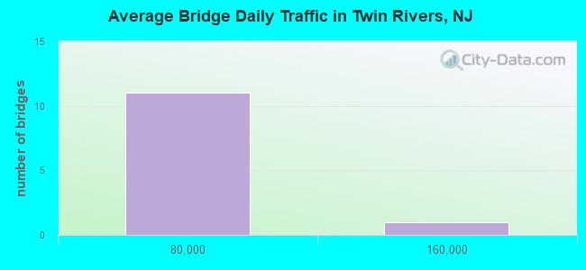
- 275,474Total average daily traffic
- 28,545Total average daily truck traffic
- National Bridge Inventory (NBI) Registered Bridges for Twin Rivers
- No street view available for this location
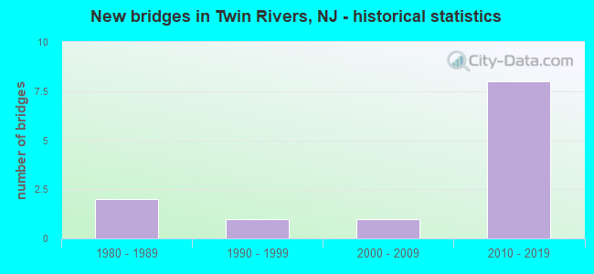
- New bridges - historical statistics
- 21980-1989
- 11990-1999
- 12000-2009
- 82010-2019
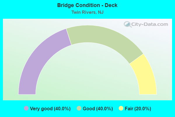
- Bridge Condition - Deck
- 40.0%Very good
- 40.0%Good
- 20.0%Fair
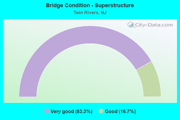
- Bridge Condition - Superstructure
- 83.3%Very good
- 16.7%Good
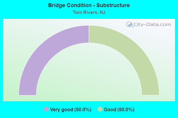
- Bridge Condition - Substructure
- 50.0%Very good
- 50.0%Good
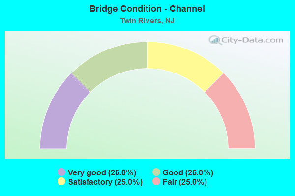
- Bridge Condition - Channel
- 25.0%Very good
- 25.0%Good
- 25.0%Satisfactory
- 25.0%Fair
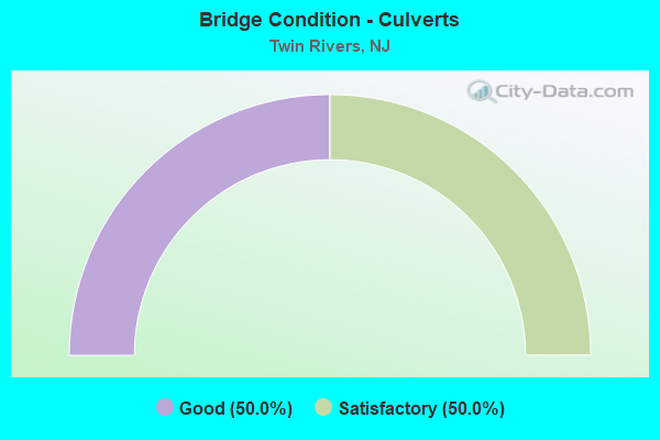
- Bridge Condition - Culverts
- 50.0%Good
- 50.0%Satisfactory
Find on map >> Show street view
Structure Number: 1108639, Location: 0.68 MI EAST OF RT 571 (Lat: 40.253061, Lng: -74.487489), Route carried "on" structure: City street , Year Built: 1980, Status: Open, Structure Length: 0.67m (2.20ft), Average Daily Traffic: 1,569 (year 2021), Truck Traffic: 1%, Average Future Daily Traffic: 1,882 (year 2041), Design Load: HS 20, Features Intersected: ROCKY BROOK, Facility Carried by Structure: DISBROW HILL ROAD
Minimum Vertical Clearance: 30+ m (98+ ft), Kilometerpoint: 1.094, Lanes on structure: 2, Owner: County Highway Agency, Approaching Roadway Width: 6.1m (20.0ft), Material/Design: Concrete, Design/Construction: Culvert, Number Of Spans In Main Unit: 1, Length of Maximum Span: 6.7m (22.0ft), Curb or Sidewalk Widths: Left: 0.8m (2.6ft), Right: 0.8m (2.6ft), Curb-To-Curb Width: 7.9m (25.9ft), Out-to-Out Width: 10.1m (33.1ft)
Condition: Channel: Satisfactory, Culverts: Good, Operating Rating: 50.8 metric tons, Method Used To Determine Operating Rating: Load Factor (LF), Inventory Rating: 29.9 metric tons, Method Used To Determine Inventory Rating: Load Factor (LF), Structural Evaluation: Better than present minimum criteria, Deck Geometry: Meets minimum limits, Waterway Adequacy: Better than present minimum criteria, Approach Roadway Alignment: Better than present minimum criteria, Designated Inspection Frequency: Every 24 months, Inspection Date: Febuary 2021, Deck Structure Type: Concrete Cast-file-Place, Wearing Surface/Protective System: Wearing Surface: Bituminous
Find on map >> Show street view
Structure Number: 125B152, Location: 0.7 MI NORTH OF NJ 33 (Lat: 40.274431, Lng: -74.472289), Route carried "on" structure: County highway 619, Year Built: 1995, Status: Open, Structure Length: 1.37m (4.49ft), Average Daily Traffic: 11,100 (year 2021), Truck Traffic: 4%, Average Future Daily Traffic: 13,542 (year 2041), Design Load: HS 25 or greater, Features Intersected: MILLSTONE RIVER, Facility Carried by Structure: APPLEGARTH ROAD
Minimum Vertical Clearance: 30+ m (98+ ft), Kilometerpoint: 2.478, Lanes on structure: 2, Base Highway Network: Yes, Owner: County Highway Agency, Approaching Roadway Width: 9.1m (29.9ft), Material/Design: Aluminum, Iron, Design/Construction: Arch - Deck, Number Of Spans In Main Unit: 2, Length of Maximum Span: 6.1m (20.0ft), Curb or Sidewalk Widths: Left: 0.2m (0.7ft), Right: 0.2m (0.7ft), Curb-To-Curb Width: 9.0m (29.5ft), Out-to-Out Width: 10.1m (33.1ft)
Condition: Superstructure: Good, Substructure: Good, Channel: Good, Operating Rating: 44.5 metric tons, Method Used To Determine Operating Rating: Field evaluation and documented engineering judgment, Inventory Rating: 32.7 metric tons, Method Used To Determine Inventory Rating: Field evaluation and documented engineering judgment, Structural Evaluation: Better than present minimum criteria, Deck Geometry: High priority of replacement, Waterway Adequacy: Superior to present desirable criteria, Approach Roadway Alignment: Equal to present desirable criteria, Length Of Structure Improvement: 1.37m (4.49ft), Designated Inspection Frequency: Every 24 months, Inspection Date: May 2021, Bridge Improvement Cost: $377,000, Roadway Improvement Cost: $43,000, Total Project Cost: $598,000 ( Estimate for 2021)
Find on map >> Show street view
Structure Number: 125B153, Location: 0.4 MILE NORTH OF RTE 33 (Lat: 40.269500, Lng: -74.466500), Route carried "on" structure: City street , Year Built: 1982, Status: Open, Structure Length: 0.98m (3.22ft), Average Daily Traffic: 245 (year 2021), Truck Traffic: 3%, Average Future Daily Traffic: 300 (year 2041), Design Load: HS 20, Features Intersected: MILLSTONE RIVER, Facility Carried by Structure: BENTLEY ROAD
Minimum Vertical Clearance: 30+ m (98+ ft), Kilometerpoint: 0.000, Lanes on structure: 2, Owner: County Highway Agency, Approaching Roadway Width: 6.7m (22.0ft), Material/Design: Concrete, Design/Construction: Culvert, Number Of Spans In Main Unit: 2, Length of Maximum Span: 4.9m (16.1ft), Curb-To-Curb Width: 9.3m (30.5ft), Out-to-Out Width: 10.1m (33.1ft)
Condition: Channel: Fair, Culverts: Satisfactory, Operating Rating: 71.7 metric tons, Method Used To Determine Operating Rating: Load Factor (LF), Inventory Rating: 42.6 metric tons, Method Used To Determine Inventory Rating: Load Factor (LF), Structural Evaluation: Equal to present minimum criteria, Deck Geometry: Equal to present minimum criteria, Waterway Adequacy: Equal to present minimum criteria, Approach Roadway Alignment: Equal to present minimum criteria, Designated Inspection Frequency: Every 24 months, Inspection Date: April 2021, Wearing Surface/Protective System: Wearing Surface: Bituminous
Find on map >> Show street view
Structure Number: 125B164, Location: 0.7 MILE NORTH OF RTE 33 (Lat: 40.277581, Lng: -74.490961), Route carried "on" structure: City street , Year Built: 2007, Status: Open, Structure Length: 1.19m (3.90ft), Average Daily Traffic: 1,949 (year 2021), Truck Traffic: 3%, Average Future Daily Traffic: 2,376 (year 2041), Design Load: HS 25 or greater, Features Intersected: MILLSTONE RIVER, Facility Carried by Structure: PROBASCO ROAD
Minimum Vertical Clearance: 30+ m (98+ ft), Kilometerpoint: 0.000, Lanes on structure: 2, Owner: County Highway Agency, Approaching Roadway Width: 9.8m (32.2ft), Material/Design: Prestressed concrete, Design/Construction: Box Beam or Girders - Multiple, Number Of Spans In Main Unit: 1, Length of Maximum Span: 9.8m (32.2ft), Curb or Sidewalk Widths: Left: 0.2m (0.7ft), Right: 1.5m (4.9ft), Curb-To-Curb Width: 9.7m (31.8ft), Out-to-Out Width: 12.3m (40.4ft)
Condition: Deck: Fair, Superstructure: Very good, Substructure: Very good, Channel: Very good, Operating Rating: 89.8 metric tons, Method Used To Determine Operating Rating: Load Factor (LF), Inventory Rating: 59.9 metric tons, Method Used To Determine Inventory Rating: Load Factor (LF), Structural Evaluation: Equal to present desirable criteria, Deck Geometry: Somewhat better than minimum adequacy, Waterway Adequacy: Equal to present desirable criteria, Approach Roadway Alignment: Equal to present minimum criteria, Designated Inspection Frequency: Every 24 months, Inspection Date: May 2021, Deck Structure Type: Concrete Cast-file-Place, Wearing Surface/Protective System: Wearing Surface: Monolithic Concrete, Deck Protection: Galvanized Reinforcing
Find on map >> Show street view
Structure Number: M06747E, Location: At Interchange 8 (Lat: 40.262519, Lng: -74.508303), Route carried "on" structure: Ramp Interstate 95, Year Built: 2013, Status: Open, Structure Length: 6.28m (20.60ft), Average Daily Traffic: 101 (year 2021), Truck Traffic: 1%, Average Future Daily Traffic: 123 (year 2041), Design Load: HL 93, Features Intersected: Int 8 Ramps NT & TS, Facility Carried by Structure: Maint. Rd (U Turn)
Minimum Vertical Clearance: 30+ m (98+ ft), Kilometerpoint: 35.615, Lanes on structure: 2, Lanes under structure: 5, Toll: On toll road, Owner: State Toll Authority, Approaching Roadway Width: 7.9m (25.9ft), Material/Design: Steel continuous, Design/Construction: Stringer/Multi-beam, Number Of Spans In Main Unit: 2, Length of Maximum Span: 36.6m (120.1ft), Curb-To-Curb Width: 8.0m (26.2ft), Out-to-Out Width: 9.1m (29.9ft)
Condition: Deck: Good, Superstructure: Very good, Substructure: Very good, Operating Rating: 71.6 metric tons, Method Used To Determine Operating Rating: Load and Resistance Factor Rating (LRFR) rating reported by rating factor(RF) method using HL-93 loadings, Inventory Rating: 55.4 metric tons, Method Used To Determine Inventory Rating: Load and Resistance Factor Rating (LRFR) rating reported by rating factor(RF) method using HL-93 loadings, Structural Evaluation: Equal to present desirable criteria, Deck Geometry: High priority of corrective action, Underclear: Meets minimum limits, Approach Roadway Alignment: Equal to present desirable criteria, Length Of Structure Improvement: 6.28m (20.60ft), Designated Inspection Frequency: Every 24 months, Inspection Date: April 2021, Bridge Improvement Cost: $1,060,000, Roadway Improvement Cost: $106,000, Total Project Cost: $1,272,000 ( Estimate for 2017), Deck Structure Type: Concrete Cast-file-Place, Wearing Surface/Protective System: Wearing Surface: Monolithic Concrete, Deck Protection: Epoxy Coated Reinforcing
Find on map >> Show street view
Structure Number: M06747F, Location: 0.2 MI EAST OF EXIT 8 (Lat: 40.266239, Lng: -74.501675), Route carried "on" structure: City street , Year Built: 2010, Status: Open, Structure Length: 4.72m (15.49ft), Average Daily Traffic: 5,360 (year 2021), Truck Traffic: 4%, Average Future Daily Traffic: 6,432 (year 2041), Design Load: HL 93, Features Intersected: NJ TPK (I-95), Facility Carried by Structure: Milford Rd
Minimum Vertical Clearance: 30+ m (98+ ft), Kilometerpoint: 0.000, Lanes on structure: 2, Lanes under structure: 7, Owner: State Toll Authority, Approaching Roadway Width: 11.0m (36.1ft), Skew: 1 degrees, Material/Design: Steel continuous, Design/Construction: Stringer/Multi-beam, Number Of Spans In Main Unit: 1, Length of Maximum Span: 45.7m (149.9ft), Curb-To-Curb Width: 11.0m (36.1ft), Out-to-Out Width: 12.1m (39.7ft)
Condition: Deck: Very good, Superstructure: Very good, Substructure: Good, Operating Rating: 67.7 metric tons, Method Used To Determine Operating Rating: Load and Resistance Factor Rating (LRFR) rating reported by rating factor(RF) method using HL-93 loadings, Inventory Rating: 52.2 metric tons, Method Used To Determine Inventory Rating: Load and Resistance Factor Rating (LRFR) rating reported by rating factor(RF) method using HL-93 loadings, Structural Evaluation: Better than present minimum criteria, Deck Geometry: Meets minimum limits, Underclear: Meets minimum limits, Approach Roadway Alignment: Equal to present desirable criteria, Designated Inspection Frequency: Every 24 months, Inspection Date: April 2021, Deck Structure Type: Concrete Cast-file-Place, Wearing Surface/Protective System: Wearing Surface: Monolithic Concrete, Deck Protection: Epoxy Coated Reinforcing
Find on map >> Show street view
Structure Number: M06747G, Location: 0.51 Mi. E. of NJTA (Lat: 40.268508, Lng: -74.499856), Route carried "on" structure: Ramp Interstate 95, Year Built: 2012, Status: Open, Structure Length: 7.89m (25.89ft), Average Daily Traffic: 2,040 (year 2021), Truck Traffic: 4%, Average Future Daily Traffic: 2,489 (year 2041), Design Load: HL 93, Features Intersected: NJ Route 33, Facility Carried by Structure: Ramps TW & WT
Minimum Vertical Clearance: 30+ m (98+ ft), Kilometerpoint: 36.275, Lanes on structure: 4, Lanes under structure: 6, Toll: On toll road, Owner: State Toll Authority, Approaching Roadway Width: 25.3m (83.0ft), Skew: 30 degrees, Material/Design: Steel, Design/Construction: Stringer/Multi-beam, Number Of Spans In Main Unit: 1, Length of Maximum Span: 78.3m (256.9ft), Curb-To-Curb Width: 24.8m (81.4ft), Out-to-Out Width: 26.8m (87.9ft)
Condition: Deck: Good, Superstructure: Very good, Substructure: Good, Operating Rating: 73.5 metric tons, Method Used To Determine Operating Rating: Load and Resistance Factor Rating (LRFR) rating reported by rating factor(RF) method using HL-93 loadings, Inventory Rating: 56.7 metric tons, Method Used To Determine Inventory Rating: Load and Resistance Factor Rating (LRFR) rating reported by rating factor(RF) method using HL-93 loadings, Structural Evaluation: Better than present minimum criteria, Deck Geometry: Superior to present desirable criteria, Underclear: Equal to present minimum criteria, Approach Roadway Alignment: Equal to present desirable criteria, Designated Inspection Frequency: Every 24 months, Inspection Date: June 2021, Deck Structure Type: Concrete Cast-file-Place, Wearing Surface/Protective System: Deck Protection: Epoxy Coated Reinforcing
Find on map >> Show street view
Structure Number: M06927R, Location: 1.7 MI NORTH OF EXIT 8 (Lat: 40.287794, Lng: -74.501231), Route carried "on" structure: City street , Year Built: 2013, Status: Open, Structure Length: 11.31m (37.11ft), Average Daily Traffic: 27,661 (year 2021), Truck Traffic: 3%, Average Future Daily Traffic: 33,752 (year 2041), Design Load: HL 93, Features Intersected: NJ TPK(I-95), Facility Carried by Structure: BRICK YARD RD.
Minimum Vertical Clearance: 30+ m (98+ ft), Kilometerpoint: 1.722, Lanes on structure: 2, Lanes under structure: 12, Owner: State Toll Authority, Approaching Roadway Width: 11.0m (36.1ft), Skew: 1 degrees, Material/Design: Steel, Design/Construction: Stringer/Multi-beam, Number Of Spans In Main Unit: 3, Length of Maximum Span: 40.5m (132.9ft), Curb or Sidewalk Widths: Left: 1.8m (5.9ft), Right: 0.0m, Curb-To-Curb Width: 11.0m (36.1ft), Out-to-Out Width: 13.7m (44.9ft)
Condition: Deck: Very good, Superstructure: Very good, Substructure: Very good, Operating Rating: 53.8 metric tons, Method Used To Determine Operating Rating: Load and Resistance Factor Rating (LRFR) rating reported by rating factor(RF) method using HL-93 loadings, Inventory Rating: 41.5 metric tons, Method Used To Determine Inventory Rating: Load and Resistance Factor Rating (LRFR) rating reported by rating factor(RF) method using HL-93 loadings, Structural Evaluation: Equal to present desirable criteria, Deck Geometry: Meets minimum limits, Underclear: Meets minimum limits, Approach Roadway Alignment: Equal to present desirable criteria, Designated Inspection Frequency: Every 24 months, Inspection Date: May 2021, Deck Structure Type: Concrete Cast-file-Place, Wearing Surface/Protective System: Deck Protection: Epoxy Coated Reinforcing
Find on map >> Show street view
Structure Number: M06747E, Location: At Interchange 8 (Lat: 40.262519, Lng: -74.508303), Route carried "under" structure: Ramp Interstate 95, Year Built: 2013, Structure Length: 0. m, Average Daily Traffic: 10,201 (year 2021), Truck Traffic: 15%, Features Intersected: Int 8 Ramps NT & TS, Facility Carried by Structure: Maint. Rd (U Turn)
Minimum Vertical Clearance: 5.51m (18.08ft), Kilometerpoint: 35.615, Lanes on structure: 2, Lanes under structure: 5, Toll: On toll road, Material/Design: Steel continuous, Design/Construction: Stringer/Multi-beam, Length of Maximum Span: 36.6m (120.1ft)
Find on map >> Show street view
Structure Number: M06747F, Location: 0.2 MI EAST OF EXIT 8 (Lat: 40.266239, Lng: -74.501675), Route carried "under" structure: Ramp Interstate 95, Year Built: 2010, Structure Length: 0. m, Average Daily Traffic: 20,600 (year 2021), Truck Traffic: 9%, Features Intersected: NJ TPK (I-95), Facility Carried by Structure: Milford Rd
Minimum Vertical Clearance: 5.59m (18.34ft), Kilometerpoint: 35.631, Lanes on structure: 2, Lanes under structure: 7, Toll: On toll road, Material/Design: Steel continuous, Design/Construction: Stringer/Multi-beam, Length of Maximum Span: 45.7m (149.9ft)
Find on map >> Show street view
Structure Number: M06747G, Location: 0.51 Mi. E. of NJTA (Lat: 40.268508, Lng: -74.499856), Route carried "under" structure: State highway 33, Year Built: 2012, Structure Length: 0. m, Average Daily Traffic: 37,382 (year 2021), Truck Traffic: 4%, Features Intersected: NJ Route 33, Facility Carried by Structure: Ramps TW & WT
Minimum Vertical Clearance: 5.92m (19.42ft), Kilometerpoint: 24.977, Lanes on structure: 4, Lanes under structure: 6, Material/Design: Steel, Design/Construction: Stringer/Multi-beam, Length of Maximum Span: 78.3m (256.9ft)
Find on map >> Show street view
Structure Number: M06927R, Location: 1.7 MI NORTH OF EXIT 8 (Lat: 40.287794, Lng: -74.501231), Route carried "under" structure: Interstate 95, Year Built: 2013, Structure Length: 0. m, Average Daily Traffic: 157,266 (year 2021), Truck Traffic: 14%, Features Intersected: NJ TPK(I-95), Facility Carried by Structure: BRICK YARD RD.
Minimum Vertical Clearance: 4.82m (15.81ft), Kilometerpoint: 38.399, Lanes on structure: 2, Lanes under structure: 12, Toll: On toll road, Material/Design: Steel, Design/Construction: Stringer/Multi-beam, Length of Maximum Span: 40.5m (132.9ft)