Bridge Statistics for Urich, Missouri (MO)
Condition, Traffic, Stress, Structural Evaluation, Project Costs
- National Bridge Inventory (NBI) Statistics
- 13Number of bridges
- 157ft / 47.6mTotal length
- $605,000Total costs
- 46,679Total average daily traffic
- 9,351Total average daily truck traffic
- National Bridge Inventory (NBI) Registered Bridges for Urich
- No street view available for this location
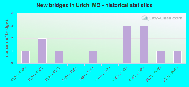
- New bridges - historical statistics
- 11920-1929
- 21930-1939
- 11940-1949
- 11960-1969
- 31980-1989
- 31990-1999
- 12000-2009
- 12010-2019

- Reconstructed bridges - Historical Statistics
- 21980-1989
- 01990-1999
- 12000-2009


- Bridge Condition - Deck
- 33.3%Very good
- 44.4%Good
- 11.1%Satisfactory
- 11.1%Fair

- Bridge Condition - Superstructure
- 11.1%Excellent
- 55.6%Good
- 33.3%Satisfactory

- Bridge Condition - Substructure
- 11.1%Very good
- 44.4%Good
- 22.2%Satisfactory
- 11.1%Fair
- 11.1%Poor

- Bridge Condition - Channel
- 11.1%Very good
- 11.1%Good
- 33.3%Satisfactory
- 44.4%Fair
Find on map >> Show street view
Structure Number: 13401, Location: S 28 T 43 N R 28 W (Lat: 38.488333, Lng: -94.030000), Route carried "on" structure: County highway 37, Year Built: 1940, Status: Posted for load, Structure Length: 0.91m (2.99ft), Average Daily Traffic: 30 (year 2021), Truck Traffic: 10%, Average Future Daily Traffic: 42 (year 2041), Design Load: H 10, Features Intersected: BR OF KNOB CR, Facility Carried by Structure: NW1501
Minimum Vertical Clearance: 30+ m (98+ ft), Kilometerpoint: 4.989, Lanes on structure: 1, Owner: County Highway Agency, Approaching Roadway Width: 5.2m (17.1ft), Material/Design: Steel, Design/Construction: Stringer/Multi-beam, Number Of Spans In Main Unit: 1, Length of Maximum Span: 8.5m (27.9ft), Curb-To-Curb Width: 4.9m (16.1ft), Out-to-Out Width: 4.9m (16.1ft)
Condition: Deck: Satisfactory, Superstructure: Satisfactory, Substructure: Fair, Channel: Satisfactory, Operating Rating: 16.2 metric tons, Method Used To Determine Operating Rating: Allowable Stress (AS), Inventory Rating: 9.0 metric tons, Method Used To Determine Inventory Rating: Allowable Stress (AS), Structural Evaluation: High priority of replacement, Deck Geometry: High priority of corrective action, Waterway Adequacy: Better than present minimum criteria, Approach Roadway Alignment: Equal to present minimum criteria, Bridge Posting: Required (Relationship of Operating Rating to Maximum Legal Load: 30.0 - 39.9% below), Length Of Structure Improvement: 0.16m (0.52ft), Designated Inspection Frequency: Every 24 months, Inspection Date: March 2021, Bridge Improvement Cost: $115,000, Roadway Improvement Cost: $12,000, Total Project Cost: $173,000 ( Estimate for 2022), Deck Structure Type: Concrete Cast-file-Place, Wearing Surface/Protective System: Wearing Surface: Gravel
Find on map >> Show street view
Structure Number: 1991, Location: S 10 T 42 N R 28 W (Lat: 38.452608, Lng: -94.004178), Route carried "on" structure: State highway K, Year Built: 1968, Status: Open, Structure Length: 16.43m (53.90ft), Average Daily Traffic: 1,189 (year 2021), Truck Traffic: 4%, Average Future Daily Traffic: 1,784 (year 2041), Design Load: H 20, Features Intersected: S GRAND RVR
Minimum Vertical Clearance: 30+ m (98+ ft), Kilometerpoint: 1.885, Lanes on structure: 2, Owner: State Highway Agency, Approaching Roadway Width: 6.7m (22.0ft), Material/Design: Steel continuous, Design/Construction: Stringer/Multi-beam, Number Of Spans In Main Unit: 3, Number Of Approach Spans: 4, Length of Maximum Span: 36.6m (120.1ft), Curb-To-Curb Width: 11.6m (38.1ft), Out-to-Out Width: 12.4m (40.7ft)
Condition: Deck: Fair, Superstructure: Satisfactory, Substructure: Satisfactory, Channel: Fair, Operating Rating: 39.6 metric tons, Method Used To Determine Operating Rating: Load Factor (LF), Inventory Rating: 23.4 metric tons, Method Used To Determine Inventory Rating: Load Factor (LF), Structural Evaluation: Equal to present minimum criteria, Deck Geometry: Equal to present minimum criteria, Waterway Adequacy: Equal to present desirable criteria, Approach Roadway Alignment: Equal to present desirable criteria, Designated Inspection Frequency: Every 24 months, Other Special Inspection Frequency: Every 24 months, Inspection Date: October 2021, Other Special Inspection Date: October 2021, Deck Structure Type: Concrete Cast-file-Place, Wearing Surface/Protective System: Wearing Surface: Bituminous
Find on map >> Show street view
Structure Number: 2054, Location: S 21 T 42 N R 28 W (Lat: 38.416136, Lng: -94.013464), Route carried "on" structure: County highway 264, Year Built: 1920, Year Reconstructed: 1986, Status: Open, Structure Length: 1.92m (6.30ft), Average Daily Traffic: 115 (year 2021), Truck Traffic: 10%, Average Future Daily Traffic: 161 (year 2041), Features Intersected: WHITE OAK CR, Facility Carried by Structure: NW300
Minimum Vertical Clearance: 30+ m (98+ ft), Kilometerpoint: 1.287, Lanes on structure: 1, Owner: County Highway Agency, Approaching Roadway Width: 5.5m (18.0ft), Material/Design: Steel, Design/Construction: Girder and Floorbeam System, Number Of Spans In Main Unit: 1, Length of Maximum Span: 18.3m (60.0ft), Curb-To-Curb Width: 5.4m (17.7ft), Out-to-Out Width: 5.6m (18.4ft)
Condition: Deck: Good, Superstructure: Satisfactory, Substructure: Good, Channel: Satisfactory, Operating Rating: 28.8 metric tons, Method Used To Determine Operating Rating: Allowable Stress (AS), Inventory Rating: 18.9 metric tons, Method Used To Determine Inventory Rating: Allowable Stress (AS), Structural Evaluation: Somewhat better than minimum adequacy, Deck Geometry: High priority of replacement, Waterway Adequacy: Better than present minimum criteria, Approach Roadway Alignment: Equal to present desirable criteria, Length Of Structure Improvement: 0.27m (0.89ft), Designated Inspection Frequency: Every 24 months, Critical Feature Inspection Frequency: Every 24 months, Inspection Date: March 2021, Critical Feature Inspection Date: March 2021, Bridge Improvement Cost: $134,000, Roadway Improvement Cost: $13,000, Total Project Cost: $201,000 ( Estimate for 2022), Deck Structure Type: Concrete Cast-file-Place, Wearing Surface/Protective System: Wearing Surface: Monolithic Concrete
Find on map >> Show street view
Structure Number: 20614, Location: S 15 T 42 N R 28 W (Lat: 38.430383, Lng: -94.000297), Route carried "on" structure: County highway 267, Year Built: 1930, Year Reconstructed: 1985, Status: Open, Structure Length: 2.29m (7.51ft), Average Daily Traffic: 50 (year 2021), Truck Traffic: 10%, Average Future Daily Traffic: 70 (year 2041), Features Intersected: WHITE OAK CR, Facility Carried by Structure: NW400
Minimum Vertical Clearance: 30+ m (98+ ft), Kilometerpoint: 0.483, Lanes on structure: 1, Owner: County Highway Agency, Approaching Roadway Width: 6.1m (20.0ft), Material/Design: Steel continuous, Design/Construction: Girder and Floorbeam System, Number Of Spans In Main Unit: 2, Length of Maximum Span: 11.3m (37.1ft), Curb-To-Curb Width: 5.4m (17.7ft), Out-to-Out Width: 5.6m (18.4ft)
Condition: Deck: Good, Superstructure: Good, Substructure: Poor, Channel: Fair, Operating Rating: 30.6 metric tons, Method Used To Determine Operating Rating: Allowable Stress (AS), Inventory Rating: 22.5 metric tons, Method Used To Determine Inventory Rating: Allowable Stress (AS), Structural Evaluation: Meets minimum limits, Deck Geometry: High priority of corrective action, Waterway Adequacy: Equal to present minimum criteria, Approach Roadway Alignment: Equal to present desirable criteria, Length Of Structure Improvement: 0.31m (1.02ft), Designated Inspection Frequency: Every 24 months, Critical Feature Inspection Frequency: Every 24 months, Underwater Inspection Frequency: Every 60 months, Inspection Date: March 2021, Critical Feature Inspection Date: March 2021, Underwater Inspection Date: Febuary 2017, Bridge Improvement Cost: $154,000, Roadway Improvement Cost: $15,000, Total Project Cost: $231,000 ( Estimate for 2022), Deck Structure Type: Concrete Cast-file-Place, Wearing Surface/Protective System: Wearing Surface: Monolithic Concrete
Find on map >> Show street view
Structure Number: 33125, Location: S 35 T 43 N R 26 W (Lat: 38.471367, Lng: -93.985283), Route carried "on" structure: County highway , Year Built: 2009, Status: Open, Structure Length: 1.00m (3.28ft), Average Daily Traffic: 30 (year 2021), Truck Traffic: 5%, Average Future Daily Traffic: 42 (year 2041), Features Intersected: BR OF WHITE CR, Facility Carried by Structure: State lands road
Minimum Vertical Clearance: 30+ m (98+ ft), Kilometerpoint: 0.000, Lanes on structure: 2, Owner: County Highway Agency, Approaching Roadway Width: 5.8m (19.0ft), Material/Design: Steel, Design/Construction: Stringer/Multi-beam, Number Of Spans In Main Unit: 1, Length of Maximum Span: 8.8m (28.9ft), Curb-To-Curb Width: 5.9m (19.4ft), Out-to-Out Width: 6.0m (19.7ft)
Condition: Deck: Very good, Superstructure: Good, Substructure: Good, Channel: Very good, Operating Rating: 76.5 metric tons, Method Used To Determine Operating Rating: Load Factor (LF), Inventory Rating: 45.9 metric tons, Method Used To Determine Inventory Rating: Load Factor (LF), Structural Evaluation: Better than present minimum criteria, Deck Geometry: Meets minimum limits, Waterway Adequacy: Equal to present minimum criteria, Approach Roadway Alignment: Equal to present desirable criteria, Designated Inspection Frequency: Every 24 months, Inspection Date: March 2021, Deck Structure Type: Concrete Cast-file-Place, Wearing Surface/Protective System: Wearing Surface: Monolithic Concrete
Find on map >> Show street view
Structure Number: 33908, Location: S 21 T 42 N R 28 W (Lat: 38.420394, Lng: -94.010039), Route carried "on" structure: State highway K, Year Built: 2012, Status: Open, Structure Length: 3.63m (11.91ft), Average Daily Traffic: 446 (year 2021), Truck Traffic: 10%, Average Future Daily Traffic: 669 (year 2041), Design Load: HS 20, Features Intersected: WHITE OAK CR
Minimum Vertical Clearance: 30+ m (98+ ft), Kilometerpoint: 5.675, Lanes on structure: 2, Owner: State Highway Agency, Approaching Roadway Width: 6.1m (20.0ft), Skew: 2 degrees, Material/Design: Prestressed concrete, Design/Construction: Box Beam or Girders - Multiple, Number Of Spans In Main Unit: 3, Length of Maximum Span: 18.3m (60.0ft), Curb-To-Curb Width: 7.3m (24.0ft), Out-to-Out Width: 7.9m (25.9ft)
Condition: Deck: Good, Superstructure: Good, Substructure: Good, Channel: Satisfactory, Operating Rating: 66.6 metric tons, Method Used To Determine Operating Rating: Load Factor (LF), Inventory Rating: 39.6 metric tons, Method Used To Determine Inventory Rating: Load Factor (LF), Structural Evaluation: Better than present minimum criteria, Deck Geometry: Meets minimum limits, Waterway Adequacy: Superior to present desirable criteria, Approach Roadway Alignment: Equal to present desirable criteria, Designated Inspection Frequency: Every 24 months, Inspection Date: September 2020, Deck Structure Type: Concrete Precast Panels, Wearing Surface/Protective System: Wearing Surface: Bituminous, Membrane: Built-up
Find on map >> Show street view
Structure Number: 3431, Location: S 34 T 43 N R 28 W (Lat: 38.466872, Lng: -94.003014), Route carried "on" structure: State highway 7, Year Built: 1988, Status: Open, Structure Length: 5.79m (19.00ft), Average Daily Traffic: 7,012 (year 2021), Truck Traffic: 23%, Average Future Daily Traffic: 12,271 (year 2041), Design Load: HS 20, Features Intersected: RT B
Minimum Vertical Clearance: 30+ m (98+ ft), Kilometerpoint: 200.051, Lanes on structure: 2, Lanes under structure: 2, Base Highway Network: Yes, Owner: State Highway Agency, Approaching Roadway Width: 13.4m (44.0ft), Skew: 2 degrees, Material/Design: Prestressed concrete continuous, Design/Construction: Stringer/Multi-beam, Number Of Spans In Main Unit: 3, Length of Maximum Span: 28.3m (92.8ft), Curb or Sidewalk Widths: Left: 0.2m (0.7ft), Right: 0.2m (0.7ft), Curb-To-Curb Width: 13.0m (42.7ft), Out-to-Out Width: 13.9m (45.6ft)
Condition: Deck: Good, Superstructure: Good, Substructure: Good, Operating Rating: 63.9 metric tons, Method Used To Determine Operating Rating: Load Factor (LF), Inventory Rating: 38.7 metric tons, Method Used To Determine Inventory Rating: Load Factor (LF), Structural Evaluation: Better than present minimum criteria, Deck Geometry: Superior to present desirable criteria, Underclear: Better than present minimum criteria, Approach Roadway Alignment: Equal to present desirable criteria, Designated Inspection Frequency: Every 24 months, Inspection Date: September 2020, Deck Structure Type: Concrete Cast-file-Place, Wearing Surface/Protective System: Wearing Surface: Monolithic Concrete, Deck Protection: Epoxy Coated Reinforcing
Find on map >> Show street view
Structure Number: 3442, Location: S 34 T 43 N R 28 W (Lat: 38.466628, Lng: -94.003047), Route carried "on" structure: State highway 7, Year Built: 1995, Status: Open, Structure Length: 5.85m (19.19ft), Average Daily Traffic: 7,162 (year 2021), Truck Traffic: 23%, Average Future Daily Traffic: 12,534 (year 2041), Design Load: HS 20, Features Intersected: RT B
Minimum Vertical Clearance: 30+ m (98+ ft), Kilometerpoint: 100.425, Lanes on structure: 2, Lanes under structure: 2, Base Highway Network: Yes, Owner: State Highway Agency, Approaching Roadway Width: 13.4m (44.0ft), Skew: 2 degrees, Material/Design: Prestressed concrete continuous, Design/Construction: Stringer/Multi-beam, Number Of Spans In Main Unit: 3, Length of Maximum Span: 28.5m (93.5ft), Curb or Sidewalk Widths: Left: 0.2m (0.7ft), Right: 0.2m (0.7ft), Curb-To-Curb Width: 11.8m (38.7ft), Out-to-Out Width: 12.6m (41.3ft)
Condition: Deck: Very good, Superstructure: Excellent, Substructure: Very good, Operating Rating: 84.6 metric tons, Method Used To Determine Operating Rating: Load Factor (LF), Inventory Rating: 50.4 metric tons, Method Used To Determine Inventory Rating: Load Factor (LF), Structural Evaluation: Equal to present desirable criteria, Deck Geometry: Better than present minimum criteria, Underclear: Better than present minimum criteria, Approach Roadway Alignment: Equal to present desirable criteria, Designated Inspection Frequency: Every 24 months, Inspection Date: September 2020, Deck Structure Type: Concrete Cast-file-Place, Wearing Surface/Protective System: Wearing Surface: Monolithic Concrete, Deck Protection: Epoxy Coated Reinforcing
Find on map >> Show street view
Structure Number: 367, Location: S 35 T 43 N R 28 W (Lat: 38.464025, Lng: -93.993153), Route carried "on" structure: State highway 7, Year Built: 1988, Status: Open, Structure Length: 0.76m (2.49ft), Average Daily Traffic: 13,951 (year 2021), Truck Traffic: 21%, Average Future Daily Traffic: 24,414 (year 2041), Design Load: HS 20, Features Intersected: HOLWELL BR
Minimum Vertical Clearance: 30+ m (98+ ft), Kilometerpoint: 101.366, Lanes on structure: 4, Base Highway Network: Yes, Owner: State Highway Agency, Approaching Roadway Width: 39.0m (128.0ft), Skew: 2 degrees, Material/Design: Concrete continuous, Design/Construction: Culvert, Number Of Spans In Main Unit: 2, Length of Maximum Span: 3.4m (11.2ft)
Condition: Channel: Fair, Culverts: Satisfactory, Inventory Rating: 77.4 metric tons, Method Used To Determine Inventory Rating: Load Factor (LF), Structural Evaluation: Equal to present minimum criteria, Waterway Adequacy: Equal to present minimum criteria, Approach Roadway Alignment: Equal to present desirable criteria, Designated Inspection Frequency: Every 24 months, Inspection Date: March 2021
Find on map >> Show street view
Structure Number: 4234, Location: S 35 T 43 N R 28 W (Lat: 38.463833, Lng: -93.985700), Route carried "on" structure: State highway 7, Year Built: 1997, Status: Open, Structure Length: 0.96m (3.15ft), Average Daily Traffic: 13,951 (year 2021), Truck Traffic: 21%, Average Future Daily Traffic: 24,414 (year 2041), Design Load: HS 20, Features Intersected: HALWELL CR
Minimum Vertical Clearance: 30+ m (98+ ft), Kilometerpoint: 102.017, Lanes on structure: 4, Base Highway Network: Yes, Owner: State Highway Agency, Approaching Roadway Width: 11.0m (36.1ft), Skew: 10 degrees, Material/Design: Concrete continuous, Design/Construction: Culvert, Number Of Spans In Main Unit: 3, Length of Maximum Span: 3.0m (9.8ft)
Condition: Channel: Fair, Culverts: Satisfactory, Operating Rating: 87.3 metric tons, Method Used To Determine Operating Rating: Field evaluation and documented engineering judgment, Inventory Rating: 52.2 metric tons, Method Used To Determine Inventory Rating: Field evaluation and documented engineering judgment, Structural Evaluation: Equal to present minimum criteria, Waterway Adequacy: Equal to present desirable criteria, Approach Roadway Alignment: Equal to present desirable criteria, Designated Inspection Frequency: Every 24 months, Inspection Date: March 2021
Find on map >> Show street view
Structure Number: 5944, Location: S 10 T 42 N R 28 W (Lat: 38.456733, Lng: -94.003356), Route carried "on" structure: State highway K, Year Built: 1939, Year Reconstructed: 2011, Status: Open, Structure Length: 8.09m (26.54ft), Average Daily Traffic: 1,189 (year 2021), Truck Traffic: 4%, Average Future Daily Traffic: 1,784 (year 2041), Design Load: H 15, Features Intersected: S GRAND RVR
Minimum Vertical Clearance: 30+ m (98+ ft), Kilometerpoint: 1.452, Lanes on structure: 2, Owner: State Highway Agency, Approaching Roadway Width: 7.9m (25.9ft), Material/Design: Steel, Design/Construction: Stringer/Multi-beam, Number Of Spans In Main Unit: 7, Length of Maximum Span: 16.0m (52.5ft), Curb-To-Curb Width: 7.9m (25.9ft), Out-to-Out Width: 8.7m (28.5ft)
Condition: Deck: Very good, Superstructure: Good, Substructure: Satisfactory, Channel: Good, Operating Rating: 78.3 metric tons, Method Used To Determine Operating Rating: Load Factor (LF), Inventory Rating: 46.8 metric tons, Method Used To Determine Inventory Rating: Load Factor (LF), Structural Evaluation: Equal to present minimum criteria, Deck Geometry: Meets minimum limits, Waterway Adequacy: Equal to present desirable criteria, Approach Roadway Alignment: Equal to present minimum criteria, Designated Inspection Frequency: Every 24 months, Inspection Date: September 2020, Deck Structure Type: Concrete Cast-file-Place, Wearing Surface/Protective System: Wearing Surface: Monolithic Concrete, Deck Protection: Epoxy Coated Reinforcing
Find on map >> Show street view
Structure Number: 3431, Location: S 34 T 43 N R 28 W (Lat: 38.466872, Lng: -94.003014), Route carried "under" structure: State highway B, Year Built: 1988, Structure Length: 0. m, Average Daily Traffic: 1,036 (year 2021), Truck Traffic: 5%, Features Intersected: RT B, Facility Carried by Structure: MO 7 N
Minimum Vertical Clearance: 4.90m (16.08ft), Kilometerpoint: 18.395, Lanes on structure: 2, Lanes under structure: 2, Material/Design: Prestressed concrete continuous, Design/Construction: Stringer/Multi-beam, Length of Maximum Span: 28.3m (92.8ft)
Find on map >> Show street view
Structure Number: 3442, Location: S 34 T 43 N R 28 W (Lat: 38.466628, Lng: -94.003047), Route carried "under" structure: State highway B, Year Built: 1995, Structure Length: 0. m, Average Daily Traffic: 518 (year 2021), Truck Traffic: 5%, Features Intersected: RT B, Facility Carried by Structure: MO 7 S
Minimum Vertical Clearance: 5.00m (16.40ft), Kilometerpoint: 18.422, Lanes on structure: 2, Lanes under structure: 2, Material/Design: Prestressed concrete continuous, Design/Construction: Stringer/Multi-beam, Length of Maximum Span: 28.5m (93.5ft)