Bridge Statistics for Verona, Mississippi (MS)
Condition, Traffic, Stress, Structural Evaluation, Project Costs
- National Bridge Inventory (NBI) Statistics
- 24Number of bridges
- 266ft / 81.5mTotal length
- $3,773,000Total costs
- 218,043Total average daily traffic
- 22,263Total average daily truck traffic
- National Bridge Inventory (NBI) Registered Bridges for Verona
- No street view available for this location
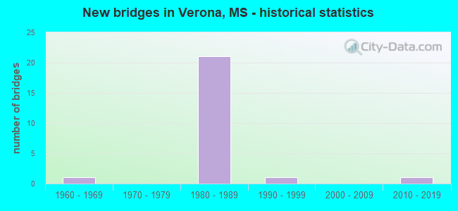
- New bridges - historical statistics
- 11960-1969
- 211980-1989
- 11990-1999
- 12010-2019
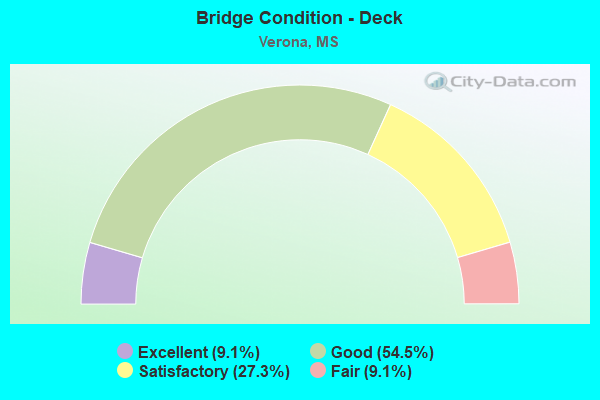
- Bridge Condition - Deck
- 9.1%Excellent
- 54.5%Good
- 27.3%Satisfactory
- 9.1%Fair
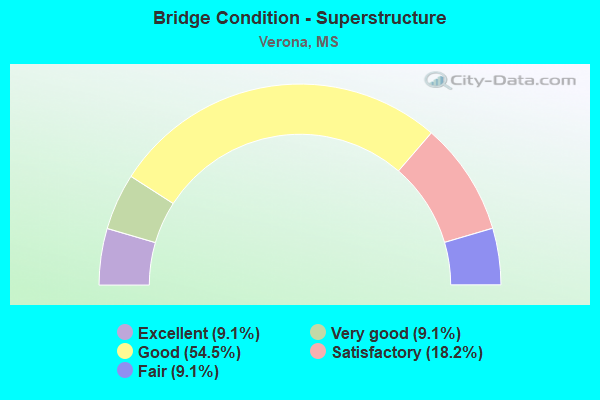
- Bridge Condition - Superstructure
- 9.1%Excellent
- 9.1%Very good
- 54.5%Good
- 18.2%Satisfactory
- 9.1%Fair
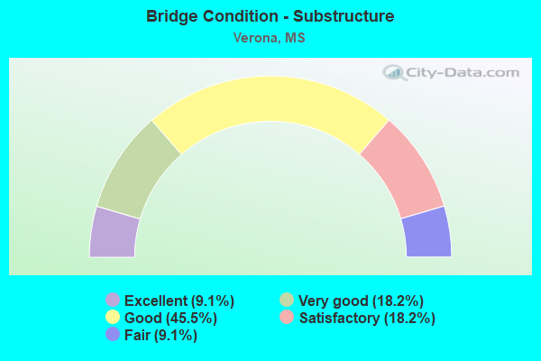
- Bridge Condition - Substructure
- 9.1%Excellent
- 18.2%Very good
- 45.5%Good
- 18.2%Satisfactory
- 9.1%Fair
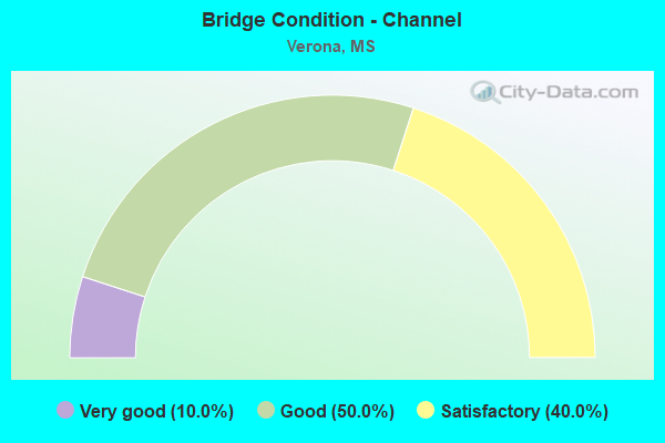
- Bridge Condition - Channel
- 10.0%Very good
- 50.0%Good
- 40.0%Satisfactory
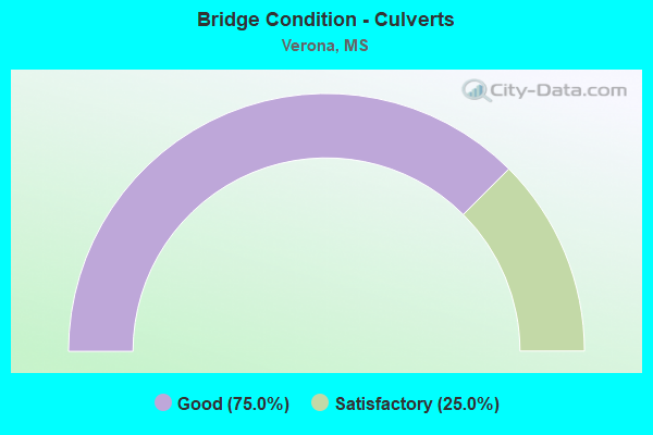
- Bridge Condition - Culverts
- 75.0%Good
- 25.0%Satisfactory
Find on map >> Show street view
Structure Number: 21000450412174A, Location: 2.5 MI N JCT US45A / US45 (Lat: 34.154172, Lng: -88.702672), Route carried "on" structure: US 45, Year Built: 1982, Status: Open, Structure Length: 10.25m (33.63ft), Average Daily Traffic: 14,500 (year 2020), Truck Traffic: 14%, Average Future Daily Traffic: 18,500 (year 2040), Design Load: HS 20, Features Intersected: BREWER ROAD
Minimum Vertical Clearance: 30+ m (98+ ft), Kilometerpoint: 41.349, Lanes on structure: 2, Lanes under structure: 4, Base Highway Network: Yes (Inventory Route: 4, Subroute: 1), Owner: State Highway Agency, Approaching Roadway Width: 13.4m (44.0ft), Skew: 11 degrees, Material/Design: Prestressed concrete, Design/Construction: Stringer/Multi-beam, Number Of Spans In Main Unit: 2, Number Of Approach Spans: 2, Length of Maximum Span: 28.0m (91.9ft), Curb-To-Curb Width: 11.7m (38.4ft), Out-to-Out Width: 12.6m (41.3ft)
Condition: Deck: Good, Superstructure: Good, Substructure: Very good, Operating Rating: 56.3 metric tons, Method Used To Determine Operating Rating: Load Factor (LF), Inventory Rating: 27.9 metric tons, Method Used To Determine Inventory Rating: Load Factor (LF), Structural Evaluation: Better than present minimum criteria, Deck Geometry: Equal to present minimum criteria, Underclear: Superior to present desirable criteria, Approach Roadway Alignment: Equal to present desirable criteria, Designated Inspection Frequency: Every 24 months, Inspection Date: October 2020, Deck Structure Type: Concrete Cast-file-Place
Find on map >> Show street view
Structure Number: 21000450412174B, Location: 2.5 MI N JCT US45A/ US45 (Lat: 34.153317, Lng: -88.702350), Route carried "on" structure: US 45, Year Built: 1982, Status: Open, Structure Length: 10.25m (33.63ft), Average Daily Traffic: 14,500 (year 2020), Truck Traffic: 14%, Average Future Daily Traffic: 16,000 (year 2040), Design Load: HS 20, Features Intersected: BREWER ROAD
Minimum Vertical Clearance: 30+ m (98+ ft), Kilometerpoint: 10.049, Lanes on structure: 2, Lanes under structure: 4, Base Highway Network: Yes (Inventory Route: 4, Subroute: 2), Owner: State Highway Agency, Approaching Roadway Width: 13.4m (44.0ft), Skew: 11 degrees, Material/Design: Prestressed concrete, Design/Construction: Stringer/Multi-beam, Number Of Spans In Main Unit: 2, Number Of Approach Spans: 2, Length of Maximum Span: 28.0m (91.9ft), Curb-To-Curb Width: 11.7m (38.4ft), Out-to-Out Width: 12.6m (41.3ft)
Condition: Deck: Good, Superstructure: Good, Substructure: Good, Operating Rating: 56.3 metric tons, Method Used To Determine Operating Rating: Load Factor (LF), Inventory Rating: 27.9 metric tons, Method Used To Determine Inventory Rating: Load Factor (LF), Structural Evaluation: Better than present minimum criteria, Deck Geometry: Equal to present minimum criteria, Underclear: Better than present minimum criteria, Approach Roadway Alignment: Equal to present desirable criteria, Designated Inspection Frequency: Every 24 months, Inspection Date: October 2020, Deck Structure Type: Concrete Cast-file-Place
Find on map >> Show street view
Structure Number: 21000450412175, Location: 2.6 MI N JCT US45A/ US45 (Lat: 34.155078, Lng: -88.702406), Route carried "on" structure: US 45, Year Built: 1983, Status: Open, Structure Length: 0.72m (2.36ft), Average Daily Traffic: 29,000 (year 2020), Truck Traffic: 14%, Average Future Daily Traffic: 32,000 (year 2040), Design Load: HS 20, Features Intersected: DITCH
Minimum Vertical Clearance: 30+ m (98+ ft), Kilometerpoint: 10.243, Lanes on structure: 4, Base Highway Network: Yes (Inventory Route: 4, Subroute: 2), Owner: State Highway Agency, Approaching Roadway Width: 13.4m (44.0ft), Skew: 14 degrees, Material/Design: Concrete, Design/Construction: Culvert, Number Of Spans In Main Unit: 2, Length of Maximum Span: 2.4m (7.9ft)
Condition: Channel: Good, Culverts: Satisfactory, Operating Rating: 87.3 metric tons, Method Used To Determine Operating Rating: Load Factor (LF), Inventory Rating: 52.2 metric tons, Method Used To Determine Inventory Rating: Load Factor (LF), Structural Evaluation: Equal to present minimum criteria, Waterway Adequacy: Equal to present desirable criteria, Approach Roadway Alignment: Equal to present desirable criteria, Designated Inspection Frequency: Every 24 months, Inspection Date: November 2020
Find on map >> Show street view
Structure Number: 21000450412203, Location: 5.4 MI N US45A/ US45 (Lat: 34.193811, Lng: -88.706697), Route carried "on" structure: US 45, Year Built: 1983, Status: Open, Structure Length: 0.77m (2.53ft), Average Daily Traffic: 31,000 (year 2020), Truck Traffic: 14%, Average Future Daily Traffic: 35,000 (year 2040), Design Load: HS 20, Features Intersected: DITCH
Minimum Vertical Clearance: 30+ m (98+ ft), Kilometerpoint: 14.576, Lanes on structure: 6, Base Highway Network: Yes (Inventory Route: 4, Subroute: 2), Owner: State Highway Agency, Approaching Roadway Width: 32.3m (106.0ft), Skew: 16 degrees, Material/Design: Concrete, Design/Construction: Culvert, Number Of Spans In Main Unit: 2, Length of Maximum Span: 1.8m (5.9ft)
Condition: Channel: Good, Culverts: Good, Structural Evaluation: Better than present minimum criteria, Waterway Adequacy: Equal to present desirable criteria, Approach Roadway Alignment: Equal to present desirable criteria, Designated Inspection Frequency: Every 24 months, Inspection Date: October 2020
Find on map >> Show street view
Structure Number: 22000450412077, Location: 6.3 MI N CHICKASAW CL (Lat: 34.153181, Lng: -88.704222), Route carried "on" structure: Spur State highway 145, Year Built: 1983, Status: Open, Structure Length: 0.72m (2.36ft), Average Daily Traffic: 1,000 (year 2020), Truck Traffic: 4%, Average Future Daily Traffic: 1,200 (year 2040), Design Load: HS 20, Features Intersected: DITCH, Facility Carried by Structure: US 45 SPUR
Minimum Vertical Clearance: 30+ m (98+ ft), Kilometerpoint: 1.403, Lanes on structure: 4, Owner: State Highway Agency, Approaching Roadway Width: 53.9m (176.8ft), Skew: 14 degrees, Material/Design: Concrete, Design/Construction: Culvert, Number Of Spans In Main Unit: 2, Length of Maximum Span: 2.4m (7.9ft)
Condition: Channel: Very good, Culverts: Good, Operating Rating: 96.7 metric tons, Method Used To Determine Operating Rating: Load Factor (LF), Inventory Rating: 57.9 metric tons, Method Used To Determine Inventory Rating: Load Factor (LF), Structural Evaluation: Better than present minimum criteria, Waterway Adequacy: Equal to present desirable criteria, Approach Roadway Alignment: Equal to present desirable criteria, Designated Inspection Frequency: Every 24 months, Inspection Date: November 2020
Find on map >> Show street view
Structure Number: 41000450412196, Location: 4.7 MI N US45A/ US45 (Lat: 34.184422, Lng: -88.706697), Route carried "on" structure: County highway , Year Built: 1982, Status: Open, Structure Length: 12.59m (41.31ft), Average Daily Traffic: 700 (year 2020), Truck Traffic: 4%, Average Future Daily Traffic: 800 (year 2040), Design Load: HS 20, Features Intersected: US 45, Facility Carried by Structure: CITY POINT ROAD
Minimum Vertical Clearance: 30+ m (98+ ft), Kilometerpoint: 1.041, Lanes on structure: 2, Lanes under structure: 4, Owner: State Highway Agency, Approaching Roadway Width: 13.4m (44.0ft), Skew: 4 degrees, Material/Design: Concrete continuous, Design/Construction: Box Beam or Girders - Single/Spread, Number Of Spans In Main Unit: 2, Number Of Approach Spans: 2, Length of Maximum Span: 36.6m (120.1ft), Curb-To-Curb Width: 9.9m (32.5ft), Out-to-Out Width: 10.8m (35.4ft)
Condition: Deck: Satisfactory, Superstructure: Satisfactory, Substructure: Good, Operating Rating: 36.8 metric tons, Method Used To Determine Operating Rating: Load Factor (LF), Inventory Rating: 20.6 metric tons, Method Used To Determine Inventory Rating: Load Factor (LF), Structural Evaluation: Somewhat better than minimum adequacy, Deck Geometry: Equal to present minimum criteria, Underclear: Equal to present minimum criteria, Approach Roadway Alignment: Equal to present desirable criteria, Designated Inspection Frequency: Every 24 months, Inspection Date: October 2020, Deck Structure Type: Concrete Cast-file-Place
Find on map >> Show street view
Structure Number: 41000450412202A, Location: 5.3 MI N JCT US45A/ US45 (Lat: 34.192314, Lng: -88.706194), Route carried "on" structure: County highway , Year Built: 1982, Status: Open, Structure Length: 10.25m (33.63ft), Average Daily Traffic: 4,800 (year 2020), Truck Traffic: 5%, Average Future Daily Traffic: 4,800 (year 2040), Design Load: HS 20, Features Intersected: US 45, Facility Carried by Structure: MAIN STREET VERONA
Minimum Vertical Clearance: 30+ m (98+ ft), Kilometerpoint: 0.211, Lanes on structure: 2, Lanes under structure: 4, Owner: State Highway Agency, Approaching Roadway Width: 12.8m (42.0ft), Skew: 11 degrees, Material/Design: Prestressed concrete, Design/Construction: Stringer/Multi-beam, Number Of Spans In Main Unit: 2, Number Of Approach Spans: 2, Length of Maximum Span: 28.0m (91.9ft), Curb-To-Curb Width: 11.7m (38.4ft), Out-to-Out Width: 12.6m (41.3ft)
Condition: Deck: Satisfactory, Superstructure: Good, Substructure: Good, Operating Rating: 54.4 metric tons, Method Used To Determine Operating Rating: Load Factor (LF), Inventory Rating: 25.8 metric tons, Method Used To Determine Inventory Rating: Load Factor (LF), Structural Evaluation: Equal to present minimum criteria, Deck Geometry: Better than present minimum criteria, Underclear: Equal to present minimum criteria, Approach Roadway Alignment: Equal to present desirable criteria, Designated Inspection Frequency: Every 24 months, Inspection Date: October 2020, Deck Structure Type: Concrete Cast-file-Place
Find on map >> Show street view
Structure Number: 41000450412202B, Location: 5.3 MI N JCT US45A/ US45 (Lat: 34.192308, Lng: -88.707256), Route carried "on" structure: County highway , Year Built: 1982, Status: Open, Structure Length: 10.25m (33.63ft), Average Daily Traffic: 4,800 (year 2020), Truck Traffic: 5%, Average Future Daily Traffic: 4,800 (year 2040), Design Load: HS 20, Features Intersected: US 45, Facility Carried by Structure: MAIN STREET VERONA
Minimum Vertical Clearance: 30+ m (98+ ft), Kilometerpoint: 0.002, Lanes on structure: 2, Lanes under structure: 4, Owner: State Highway Agency, Approaching Roadway Width: 9.9m (32.5ft), Skew: 11 degrees, Material/Design: Prestressed concrete, Design/Construction: Stringer/Multi-beam, Number Of Spans In Main Unit: 2, Number Of Approach Spans: 2, Length of Maximum Span: 28.0m (91.9ft), Curb-To-Curb Width: 11.7m (38.4ft), Out-to-Out Width: 12.6m (41.3ft)
Condition: Deck: Good, Superstructure: Good, Substructure: Good, Operating Rating: 54.1 metric tons, Method Used To Determine Operating Rating: Load Factor (LF), Inventory Rating: 25.0 metric tons, Method Used To Determine Inventory Rating: Load Factor (LF), Structural Evaluation: Equal to present minimum criteria, Deck Geometry: Better than present minimum criteria, Underclear: Equal to present minimum criteria, Approach Roadway Alignment: Equal to present desirable criteria, Designated Inspection Frequency: Every 24 months, Inspection Date: October 2020, Deck Structure Type: Concrete Cast-file-Place
Find on map >> Show street view
Structure Number: SA4100000000131, Location: SEC 25 T10S R 5E B (Lat: 34.191806, Lng: -88.726000), Route carried "on" structure: County highway 652, Year Built: 1983, Status: Open, Structure Length: 0.94m (3.08ft), Average Daily Traffic: 7,205 (year 2022), Truck Traffic: 10%, Average Future Daily Traffic: 10,800 (year 2040), Design Load: H 15, Features Intersected: LOUISA CREEK, Facility Carried by Structure: PALMETTO ROAD
Minimum Vertical Clearance: 30+ m (98+ ft), Kilometerpoint: 9.977, Lanes on structure: 2, Owner: City or Municipal Highway Agency, Approaching Roadway Width: 7.9m (25.9ft), Material/Design: Concrete, Design/Construction: Channel Beam, Number Of Spans In Main Unit: 1, Length of Maximum Span: 9.4m (30.8ft), Curb or Sidewalk Widths: Left: 0.2m (0.7ft), Right: 0.2m (0.7ft), Curb-To-Curb Width: 8.1m (26.6ft), Out-to-Out Width: 8.5m (27.9ft)
Condition: Deck: Satisfactory, Superstructure: Satisfactory, Substructure: Satisfactory, Channel: Satisfactory, Operating Rating: 42.8 metric tons, Method Used To Determine Operating Rating: Load Factor (LF), Inventory Rating: 25.7 metric tons, Method Used To Determine Inventory Rating: Load Factor (LF), Structural Evaluation: Equal to present minimum criteria, Deck Geometry: High priority of replacement, Waterway Adequacy: Equal to present desirable criteria, Approach Roadway Alignment: Equal to present desirable criteria, Length Of Structure Improvement: 1.74m (5.71ft), Designated Inspection Frequency: Every 24 months, Inspection Date: January 2022, Bridge Improvement Cost: $103,000, Roadway Improvement Cost: $10,000, Total Project Cost: $127,000 ( Estimate for 2017), Deck Structure Type: Concrete Precast Panels, Wearing Surface/Protective System: Wearing Surface: Monolithic Concrete
Find on map >> Show street view
Structure Number: SA4100000000135, Location: SEC 33 T10S R 5E B (Lat: 34.165750, Lng: -88.781000), Route carried "on" structure: County highway 1827, Year Built: 1982, Status: Posted for load, Structure Length: 0.94m (3.08ft), Average Daily Traffic: 838 (year 2022), Truck Traffic: 9%, Average Future Daily Traffic: 1,245 (year 2040), Design Load: H 15, Features Intersected: CHIWAPA BRANCH, Facility Carried by Structure: CR 261
Minimum Vertical Clearance: 30+ m (98+ ft), Kilometerpoint: 8.046, Lanes on structure: 2, Owner: County Highway Agency, Approaching Roadway Width: 7.3m (24.0ft), Material/Design: Concrete, Design/Construction: Channel Beam, Number Of Spans In Main Unit: 1, Length of Maximum Span: 9.4m (30.8ft), Curb or Sidewalk Widths: Left: 0.2m (0.7ft), Right: 0.2m (0.7ft), Curb-To-Curb Width: 8.1m (26.6ft), Out-to-Out Width: 8.5m (27.9ft)
Condition: Deck: Good, Superstructure: Good, Substructure: Good, Channel: Satisfactory, Operating Rating: 42.7 metric tons, Method Used To Determine Operating Rating: Load Factor (LF), Inventory Rating: 25.6 metric tons, Method Used To Determine Inventory Rating: Load Factor (LF), Structural Evaluation: Equal to present minimum criteria, Deck Geometry: Somewhat better than minimum adequacy, Waterway Adequacy: Better than present minimum criteria, Approach Roadway Alignment: Equal to present desirable criteria, Length Of Structure Improvement: 1.74m (5.71ft), Designated Inspection Frequency: Every 24 months, Inspection Date: January 2022, Bridge Improvement Cost: $103,000, Roadway Improvement Cost: $10,000, Total Project Cost: $127,000 ( Estimate for 2017), Deck Structure Type: Concrete Precast Panels, Wearing Surface/Protective System: Wearing Surface: Bituminous
Find on map >> Show street view
Structure Number: SA4100000000136, Location: SEC 36 T10S R 5E (Lat: 34.162500, Lng: -88.729667), Route carried "on" structure: County highway 173, Year Built: 1983, Status: Posted for load, Structure Length: 3.26m (10.70ft), Average Daily Traffic: 300 (year 2021), Truck Traffic: 8%, Average Future Daily Traffic: 450 (year 2043), Features Intersected: COONEWAH CREEK, Facility Carried by Structure: CR 590
Minimum Vertical Clearance: 30+ m (98+ ft), Kilometerpoint: 1.770, Lanes on structure: 2, Owner: County Highway Agency, Approaching Roadway Width: 6.7m (22.0ft), Material/Design: Steel, Design/Construction: Stringer/Multi-beam, Number Of Spans In Main Unit: 1, Number Of Approach Spans: 1, Length of Maximum Span: 22.9m (75.1ft), Curb-To-Curb Width: 8.0m (26.2ft), Out-to-Out Width: 8.6m (28.2ft)
Condition: Deck: Good, Superstructure: Good, Substructure: Satisfactory, Channel: Satisfactory, Operating Rating: 28.5 metric tons, Method Used To Determine Operating Rating: Load Factor (LF), Inventory Rating: 17.0 metric tons, Method Used To Determine Inventory Rating: Load Factor (LF), Structural Evaluation: Somewhat better than minimum adequacy, Deck Geometry: Somewhat better than minimum adequacy, Waterway Adequacy: Equal to present desirable criteria, Approach Roadway Alignment: Equal to present desirable criteria, Bridge Posting: Required (Relationship of Operating Rating to Maximum Legal Load: 30.0 - 39.9% below), Length Of Structure Improvement: 4.13m (13.55ft), Designated Inspection Frequency: Every 24 months, Inspection Date: December 2021, Bridge Improvement Cost: $381,000, Roadway Improvement Cost: $305,000, Total Project Cost: $686,000 ( Estimate for 2021), Deck Structure Type: Concrete Cast-file-Place, Wearing Surface/Protective System: Wearing Surface: Bituminous
Find on map >> Show street view
Structure Number: SA410000000015, Location: SEC 31 T10S R 6E (Lat: 34.163139, Lng: -88.714417), Route carried "on" structure: County highway 321, Year Built: 1985, Status: Open, Structure Length: 1.49m (4.89ft), Average Daily Traffic: 800 (year 2022), Truck Traffic: 8%, Average Future Daily Traffic: 1,200 (year 2040), Design Load: HS 20, Features Intersected: LOUISA CREEK BRANCH, Facility Carried by Structure: CDF BLVD
Minimum Vertical Clearance: 30+ m (98+ ft), Kilometerpoint: 0.804, Lanes on structure: 4, Owner: County Highway Agency, Approaching Roadway Width: 14.6m (47.9ft), Skew: 4 degrees, Material/Design: Concrete, Design/Construction: Culvert, Number Of Spans In Main Unit: 2, Length of Maximum Span: 4.9m (16.1ft)
Condition: Channel: Good, Culverts: Good, Operating Rating: 56.9 metric tons, Method Used To Determine Operating Rating: Load Factor (LF), Inventory Rating: 34.0 metric tons, Method Used To Determine Inventory Rating: Load Factor (LF), Structural Evaluation: Better than present minimum criteria, Waterway Adequacy: Equal to present desirable criteria, Approach Roadway Alignment: Equal to present desirable criteria, Designated Inspection Frequency: Every 24 months, Inspection Date: January 2022
Find on map >> Show street view
Structure Number: SA4100000000164, Location: SEC 4 T11S R 5E (Lat: 34.154917, Lng: -88.779639), Route carried "on" structure: County highway 16, Year Built: 1966, Status: Posted for load, Structure Length: 1.74m (5.71ft), Average Daily Traffic: 200 (year 2016), Truck Traffic: 8%, Average Future Daily Traffic: 300 (year 2036), Design Load: H 10, Features Intersected: CHIWAPA CREEK NO FORK, Facility Carried by Structure: CR 185
Minimum Vertical Clearance: 30+ m (98+ ft), Kilometerpoint: 2.092, Lanes on structure: 2, Owner: County Highway Agency, Approaching Roadway Width: 5.2m (17.1ft), Material/Design: Wood or Timber, Design/Construction: Stringer/Multi-beam, Number Of Spans In Main Unit: 3, Length of Maximum Span: 5.8m (19.0ft), Curb-To-Curb Width: 6.9m (22.6ft), Out-to-Out Width: 7.4m (24.3ft)
Condition: Deck: Fair, Superstructure: Fair, Substructure: Fair, Channel: Good, Operating Rating: 10.8 metric tons, Method Used To Determine Operating Rating: Allowable Stress (AS), Inventory Rating: 6.0 metric tons, Method Used To Determine Inventory Rating: Allowable Stress (AS), Structural Evaluation: High priority of replacement, Deck Geometry: Meets minimum limits, Waterway Adequacy: Equal to present desirable criteria, Approach Roadway Alignment: Equal to present minimum criteria, Bridge Posting: Required (Relationship of Operating Rating to Maximum Legal Load: > 39.9% below), Length Of Structure Improvement: 2.10m (6.89ft), Designated Inspection Frequency: Every 12 months, Inspection Date: January 2021, Bridge Improvement Cost: $126,000, Roadway Improvement Cost: $13,000, Total Project Cost: $156,000 ( Estimate for 2017), Deck Structure Type: Wood or Timber, Wearing Surface/Protective System: Wearing Surface: Bituminous
Find on map >> Show street view
Structure Number: SA4100000000197, Location: SEC 6 T11S R 6E B (Lat: 34.151917, Lng: -88.712694), Route carried "on" structure: County highway 1, Year Built: 1982, Status: Open, Structure Length: 9.06m (29.72ft), Average Daily Traffic: 2,300 (year 2016), Truck Traffic: 8%, Average Future Daily Traffic: 3,450 (year 2036), Design Load: HS 20, Features Intersected: KCS RAILROAD/LOUISA CRK, Facility Carried by Structure: CR 520
Minimum Vertical Clearance: 30+ m (98+ ft), Kilometerpoint: 7.821, Lanes on structure: 2, Lanes under structure: 2, Owner: County Highway Agency, Approaching Roadway Width: 7.6m (24.9ft), Material/Design: Prestressed concrete, Design/Construction: Stringer/Multi-beam, Number Of Spans In Main Unit: 4, Length of Maximum Span: 34.1m (111.9ft), Curb-To-Curb Width: 11.7m (38.4ft), Out-to-Out Width: 12.6m (41.3ft)
Condition: Deck: Good, Superstructure: Very good, Substructure: Very good, Channel: Satisfactory, Operating Rating: 52.8 metric tons, Method Used To Determine Operating Rating: Load Factor (LF), Inventory Rating: 28.4 metric tons, Method Used To Determine Inventory Rating: Load Factor (LF), Structural Evaluation: Better than present minimum criteria, Deck Geometry: Somewhat better than minimum adequacy, Underclear: Better than present minimum criteria, Waterway Adequacy: Superior to present desirable criteria, Approach Roadway Alignment: Equal to present desirable criteria, Length Of Structure Improvement: 13.59m (44.59ft), Designated Inspection Frequency: Every 24 months, Inspection Date: April 2020, Bridge Improvement Cost: $922,000, Roadway Improvement Cost: $738,000, Total Project Cost: $1,660,000 ( Estimate for 2019), Deck Structure Type: Concrete Cast-file-Place
Find on map >> Show street view
Structure Number: SA410000000A163, Location: SEC 4 T11S R 5E (Lat: 34.153972, Lng: -88.782389), Route carried "on" structure: County highway 16, Year Built: 2019, Status: Open, Structure Length: 8.23m (27.00ft), Average Daily Traffic: 200 (year 2015), Truck Traffic: 8%, Average Future Daily Traffic: 300 (year 2038), Design Load: HL 93, Features Intersected: CHIWAPA CREEK, Facility Carried by Structure: CR 185
Minimum Vertical Clearance: 30+ m (98+ ft), Kilometerpoint: 1.770, Lanes on structure: 2, Owner: County Highway Agency, Approaching Roadway Width: 9.1m (29.9ft), Skew: 4 degrees, Material/Design: Prestressed concrete, Design/Construction: Stringer/Multi-beam, Number Of Spans In Main Unit: 1, Number Of Approach Spans: 4, Length of Maximum Span: 33.5m (109.9ft), Curb-To-Curb Width: 8.5m (27.9ft), Out-to-Out Width: 9.4m (30.8ft)
Condition: Deck: Excellent, Superstructure: Excellent, Substructure: Excellent, Channel: Good, Operating Rating: 53.5 metric tons, Method Used To Determine Operating Rating: Load and Resistance Factor Rating (LRFR) rating reported by rating factor(RF) method using HL-93 loadings, Inventory Rating: 36.9 metric tons, Method Used To Determine Inventory Rating: Load and Resistance Factor Rating (LRFR) rating reported by rating factor(RF) method using HL-93 loadings, Structural Evaluation: Superior to present desirable criteria, Deck Geometry: Equal to present minimum criteria, Waterway Adequacy: Equal to present desirable criteria, Approach Roadway Alignment: Better than present minimum criteria, Length Of Structure Improvement: 12.34m (40.49ft), Designated Inspection Frequency: Every 24 months, Inspection Date: December 2019, Bridge Improvement Cost: $565,000, Roadway Improvement Cost: $452,000, Total Project Cost: $1,017,000 ( Estimate for 2019), Deck Structure Type: Concrete Cast-file-Place
Find on map >> Show street view
Structure Number: 21000450412183, Location: 8.2 MI N MONROE CL (Lat: 34.166650, Lng: -88.703069), Route carried "under" structure: US 45, Year Built: 1981, Structure Length: 0. m, Average Daily Traffic: 12,500 (year 2017), Truck Traffic: 8%, Features Intersected: US 45, Facility Carried by Structure: KCS RR
Minimum Vertical Clearance: 4.91m (16.11ft), Kilometerpoint: 39.965, Lanes under structure: 4, Material/Design: Steel, Design/Construction: Girder and Floorbeam System, Length of Maximum Span: 27.1m (88.9ft)
Find on map >> Show street view
Structure Number: 21000450412183, Location: 8.2 MI N MONROE CL (Lat: 34.166650, Lng: -88.702781), Route carried "under" structure: US 45, Year Built: 1981, Structure Length: 0. m, Average Daily Traffic: 12,500 (year 2017), Truck Traffic: 8%, Features Intersected: US 45, Facility Carried by Structure: KCS RR
Minimum Vertical Clearance: 4.97m (16.31ft), Kilometerpoint: 11.528, Lanes under structure: 4, Material/Design: Steel, Design/Construction: Girder and Floorbeam System, Length of Maximum Span: 27.1m (88.9ft)
Find on map >> Show street view
Structure Number: 31001450410036, Location: 6.2 MI S SR 6 (Lat: 34.160381, Lng: -88.719389), Route carried "under" structure: State highway 145, Year Built: 1997, Structure Length: 0. m, Average Daily Traffic: 7,900 (year 2017), Truck Traffic: 4%, Features Intersected: CONVEYOR BELT, Facility Carried by Structure: CONVEYOR BELT
Minimum Vertical Clearance: 5.73m (18.80ft), Kilometerpoint: 7.651, Lanes under structure: 4, Material/Design: Steel, Design/Construction: Truss - Thru, Length of Maximum Span: 33.8m (110.9ft)
Find on map >> Show street view
Structure Number: 41000450412196, Location: 4.7 MI N US45A/ US45 (Lat: 34.184161, Lng: -88.706319), Route carried "under" structure: US 45, Year Built: 1982, Structure Length: 0. m, Average Daily Traffic: 12,500 (year 2017), Truck Traffic: 8%, Features Intersected: US 45, Facility Carried by Structure: CITY POINT ROAD
Minimum Vertical Clearance: 5.06m (16.60ft), Kilometerpoint: 37.989, Lanes on structure: 2, Lanes under structure: 4, Material/Design: Concrete continuous, Design/Construction: Box Beam or Girders - Single/Spread, Length of Maximum Span: 36.6m (120.1ft)
Find on map >> Show street view
Structure Number: 41000450412196, Location: 4.7 MI N US45A/ US45 (Lat: 34.183961, Lng: -88.706019), Route carried "under" structure: US 45, Year Built: 1982, Structure Length: 0. m, Average Daily Traffic: 12,500 (year 2017), Truck Traffic: 8%, Features Intersected: US 45, Facility Carried by Structure: CITY POINT ROAD
Minimum Vertical Clearance: 5.06m (16.60ft), Kilometerpoint: 13.481, Lanes on structure: 2, Lanes under structure: 4, Material/Design: Concrete continuous, Design/Construction: Box Beam or Girders - Single/Spread, Length of Maximum Span: 36.6m (120.1ft)
Find on map >> Show street view
Structure Number: 41000450412202A, Location: 5.3 MI N JCT US45A/ US45 (Lat: 34.192431, Lng: -88.706881), Route carried "under" structure: US 45, Year Built: 1982, Structure Length: 0. m, Average Daily Traffic: 12,000 (year 2017), Truck Traffic: 8%, Features Intersected: US 45, Facility Carried by Structure: MAIN STREET VERONA
Minimum Vertical Clearance: 5.24m (17.19ft), Kilometerpoint: 37.070, Lanes on structure: 2, Lanes under structure: 4, Material/Design: Prestressed concrete, Design/Construction: Stringer/Multi-beam, Length of Maximum Span: 28.0m (91.9ft)
Find on map >> Show street view
Structure Number: 41000450412202A, Location: 5.3 MI N JCT US45A/ US45 (Lat: 34.192381, Lng: -88.706600), Route carried "under" structure: US 45, Year Built: 1982, Structure Length: 0. m, Average Daily Traffic: 12,000 (year 2017), Truck Traffic: 8%, Features Intersected: US 45, Facility Carried by Structure: MAIN STREET VERONA
Minimum Vertical Clearance: 5.15m (16.90ft), Kilometerpoint: 14.417, Lanes on structure: 2, Lanes under structure: 4, Material/Design: Prestressed concrete, Design/Construction: Stringer/Multi-beam, Length of Maximum Span: 28.0m (91.9ft)
Find on map >> Show street view
Structure Number: 41000450412202B, Location: 5.3 MI N JCT US45A/ US45 (Lat: 34.192239, Lng: -88.706869), Route carried "under" structure: US 45, Year Built: 1982, Structure Length: 0. m, Average Daily Traffic: 12,000 (year 2017), Truck Traffic: 8%, Features Intersected: US 45, Facility Carried by Structure: MAIN STREET VERONA
Minimum Vertical Clearance: 5.33m (17.49ft), Kilometerpoint: 37.091, Lanes on structure: 2, Lanes under structure: 4, Material/Design: Prestressed concrete, Design/Construction: Stringer/Multi-beam, Length of Maximum Span: 28.0m (91.9ft)
Find on map >> Show street view
Structure Number: 41000450412202B, Location: 5.3 MI N JCT US45A/ US45 (Lat: 34.192200, Lng: -88.706589), Route carried "under" structure: US 45, Year Built: 1982, Structure Length: 0. m, Average Daily Traffic: 12,000 (year 2017), Truck Traffic: 8%, Features Intersected: US 45, Facility Carried by Structure: MAIN STREET VERONA
Minimum Vertical Clearance: 5.24m (17.19ft), Kilometerpoint: 14.397, Lanes on structure: 2, Lanes under structure: 4, Material/Design: Prestressed concrete, Design/Construction: Stringer/Multi-beam, Length of Maximum Span: 28.0m (91.9ft)