Bridge Statistics for Vicksburg, Michigan (MI)
Condition, Traffic, Stress, Structural Evaluation, Project Costs
- National Bridge Inventory (NBI) Statistics
- 12Number of bridges
- 56ft / 17.1mTotal length
- $1,279,000Total costs
- 14,760Total average daily traffic
- 459Total average daily truck traffic
- 25,890Total future (year 2024) average daily traffic
- National Bridge Inventory (NBI) Registered Bridges for Vicksburg
- No street view available for this location
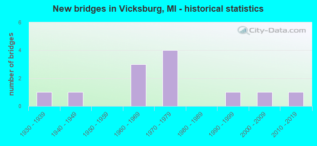
- New bridges - historical statistics
- 11930-1939
- 11940-1949
- 31960-1969
- 41970-1979
- 11990-1999
- 12000-2009
- 12010-2019
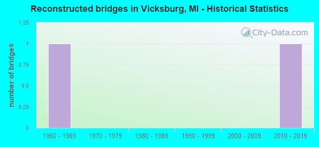
- Reconstructed bridges - Historical Statistics
- 11960-1969
- 01970-1979
- 01980-1989
- 01990-1999
- 02000-2009
- 12010-2019
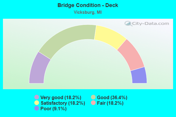
- Bridge Condition - Deck
- 18.2%Very good
- 36.4%Good
- 18.2%Satisfactory
- 18.2%Fair
- 9.1%Poor
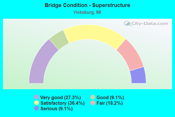
- Bridge Condition - Superstructure
- 27.3%Very good
- 9.1%Good
- 36.4%Satisfactory
- 18.2%Fair
- 9.1%Serious
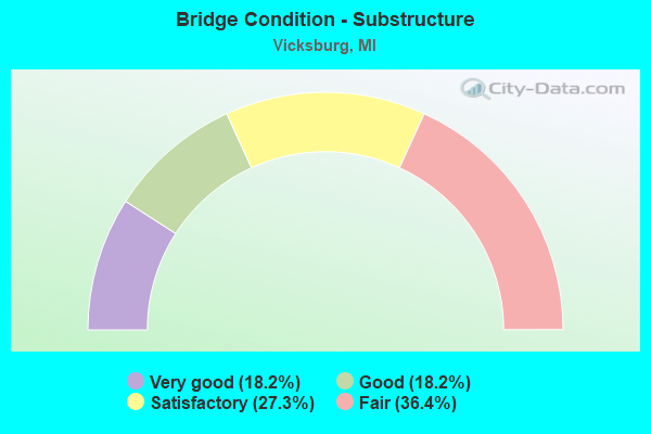
- Bridge Condition - Substructure
- 18.2%Very good
- 18.2%Good
- 27.3%Satisfactory
- 36.4%Fair
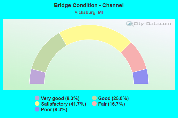
- Bridge Condition - Channel
- 8.3%Very good
- 25.0%Good
- 41.7%Satisfactory
- 16.7%Fair
- 8.3%Poor
Find on map >> Show street view
Structure Number: 4621, Location: 1.75MI S & 0.75MI E /VICK (Lat: 42.085361, Lng: -85.508800), Route carried "on" structure: County highway , Year Built: 1972, Status: Posted for load, Structure Length: 1.60m (5.25ft), Average Daily Traffic: 665 (year 2018), Truck Traffic: 3%, Average Future Daily Traffic: 960 (year 2025), Design Load: H 20, Features Intersected: PORTAGE CREEK, Facility Carried by Structure: Y AVENUE
Minimum Vertical Clearance: 30.48m (100.00ft), Kilometerpoint: 5.142, Lanes on structure: 2, Owner: County Highway Agency, Approaching Roadway Width: 9.1m (29.9ft), Material/Design: Wood or Timber, Design/Construction: Slab, Number Of Spans In Main Unit: 2, Length of Maximum Span: 7.9m (25.9ft), Curb or Sidewalk Widths: Left: 0.2m (0.7ft), Right: 0.2m (0.7ft), Curb-To-Curb Width: 10.7m (35.1ft), Out-to-Out Width: 11.2m (36.7ft)
Condition: Deck: Satisfactory, Superstructure: Satisfactory, Substructure: Fair, Channel: Fair, Operating Rating: 27.4 metric tons, Method Used To Determine Operating Rating: Allowable Stress (AS), Inventory Rating: 19.4 metric tons, Method Used To Determine Inventory Rating: Allowable Stress (AS), Structural Evaluation: Somewhat better than minimum adequacy, Deck Geometry: Equal to present minimum criteria, Waterway Adequacy: Better than present minimum criteria, Approach Roadway Alignment: Equal to present desirable criteria, Bridge Posting: Required (Relationship of Operating Rating to Maximum Legal Load: > 39.9% below), Length Of Structure Improvement: 1.62m (5.31ft), Designated Inspection Frequency: Every 24 months, Inspection Date: March 2021, Bridge Improvement Cost: $200,000, Total Project Cost: $250,000, Deck Structure Type: Wood or Timber, Wearing Surface/Protective System: Wearing Surface: Wood or Timber
Find on map >> Show street view
Structure Number: 4622, Location: 2.25MI S & 1.5MI E / VICK (Lat: 42.078161, Lng: -85.494050), Route carried "on" structure: County highway , Year Built: 1966, Status: Open, Structure Length: 1.22m (4.00ft), Average Daily Traffic: 720 (year 2007), Truck Traffic: 2%, Average Future Daily Traffic: 850 (year 2025), Design Load: H 20, Features Intersected: PORTAGE RIVER, Facility Carried by Structure: YZ AVENUE
Minimum Vertical Clearance: 30.48m (100.00ft), Kilometerpoint: 0.430, Lanes on structure: 2, Owner: County Highway Agency, Approaching Roadway Width: 10.7m (35.1ft), Material/Design: Wood or Timber, Design/Construction: Slab, Number Of Spans In Main Unit: 2, Length of Maximum Span: 5.6m (18.4ft), Curb or Sidewalk Widths: Left: 0.2m (0.7ft), Right: 0.2m (0.7ft), Curb-To-Curb Width: 8.5m (27.9ft), Out-to-Out Width: 9.0m (29.5ft)
Condition: Deck: Fair, Superstructure: Fair, Substructure: Fair, Channel: Fair, Operating Rating: 97.2 metric tons, Method Used To Determine Operating Rating: Allowable Stress (AS) rating reported by rating factor (RF) method using MS18 loading, Inventory Rating: 77.4 metric tons, Method Used To Determine Inventory Rating: Allowable Stress (AS) rating reported by rating factor (RF) method using MS18 loading, Structural Evaluation: Somewhat better than minimum adequacy, Deck Geometry: Somewhat better than minimum adequacy, Waterway Adequacy: Equal to present desirable criteria, Approach Roadway Alignment: Equal to present desirable criteria, Designated Inspection Frequency: Every 24 months, Inspection Date: June 2021, Deck Structure Type: Wood or Timber, Wearing Surface/Protective System: Wearing Surface: Bituminous
Find on map >> Show street view
Structure Number: 4624, Location: 2 MI EAST OF VICKSBURG (Lat: 42.114622, Lng: -85.485486), Route carried "on" structure: County highway 3912, Year Built: 1993, Status: Open, Structure Length: 1.83m (6.00ft), Average Daily Traffic: 4,271 (year 2015), Truck Traffic: 3%, Average Future Daily Traffic: 6,923 (year 2035), Design Load: HS 20, Features Intersected: PORTAGE RIVER, Facility Carried by Structure: W AVENUE
Minimum Vertical Clearance: 30.48m (100.00ft), Kilometerpoint: 23.005, Lanes on structure: 2, Owner: County Highway Agency, Approaching Roadway Width: 12.2m (40.0ft), Skew: 1 degrees, Material/Design: Prestressed concrete, Design/Construction: Box Beam or Girders - Multiple, Number Of Spans In Main Unit: 1, Length of Maximum Span: 17.0m (55.8ft), Curb-To-Curb Width: 12.6m (41.3ft), Out-to-Out Width: 13.4m (44.0ft)
Condition: Deck: Good, Superstructure: Good, Substructure: Good, Channel: Good, Operating Rating: 71.0 metric tons, Method Used To Determine Operating Rating: Load and Resistance Factor Rating (LRFR) rating reported by rating factor(RF) method using HL-93 loadings, Inventory Rating: 54.8 metric tons, Method Used To Determine Inventory Rating: Load and Resistance Factor Rating (LRFR) rating reported by rating factor(RF) method using HL-93 loadings, Structural Evaluation: Better than present minimum criteria, Deck Geometry: Equal to present minimum criteria, Waterway Adequacy: Superior to present desirable criteria, Approach Roadway Alignment: Equal to present desirable criteria, Designated Inspection Frequency: Every 24 months, Inspection Date: June 2021, Deck Structure Type: Concrete Cast-file-Place, Wearing Surface/Protective System: Wearing Surface: Monolithic Concrete, Deck Protection: Epoxy Coated Reinforcing
Find on map >> Show street view
Structure Number: 4625, Location: 1 MI S OF INDIAN LAKE (Lat: 42.127403, Lng: -85.480508), Route carried "on" structure: County highway , Year Built: 1962, Status: Posted for load, Structure Length: 1.52m (4.99ft), Average Daily Traffic: 784 (year 2019), Truck Traffic: 3%, Average Future Daily Traffic: 1,056 (year 2039), Design Load: H 20, Features Intersected: PORTAGE RIVER, Facility Carried by Structure: 29TH STREET
Minimum Vertical Clearance: 30.48m (100.00ft), Kilometerpoint: 1.429, Lanes on structure: 2, Owner: County Highway Agency, Approaching Roadway Width: 9.1m (29.9ft), Material/Design: Prestressed concrete, Design/Construction: Box Beam or Girders - Multiple, Number Of Spans In Main Unit: 1, Length of Maximum Span: 13.7m (44.9ft), Curb-To-Curb Width: 7.3m (24.0ft), Out-to-Out Width: 8.8m (28.9ft)
Condition: Deck: Very good, Superstructure: Satisfactory, Substructure: Satisfactory, Channel: Satisfactory, Operating Rating: 38.9 metric tons, Method Used To Determine Operating Rating: Load Factor (LF) rating reported by rating factor (RF) method using MS18 loading, Inventory Rating: 23.3 metric tons, Method Used To Determine Inventory Rating: Load Factor (LF) rating reported by rating factor (RF) method using MS18 loading, Structural Evaluation: Equal to present minimum criteria, Deck Geometry: Meets minimum limits, Waterway Adequacy: Better than present minimum criteria, Approach Roadway Alignment: Equal to present desirable criteria, Bridge Posting: Required (Relationship of Operating Rating to Maximum Legal Load: 20.0 - 29.9% below), Designated Inspection Frequency: Every 24 months, Underwater Inspection Frequency: Every 60 months, Inspection Date: October 2020, Underwater Inspection Date: June 2017, Deck Structure Type: Concrete Precast Panels, Wearing Surface/Protective System: Wearing Surface: Bituminous, Membrane: Preformed Fabric
Find on map >> Show street view
Structure Number: 4626, Location: 0.9 MI SE OF INDIAN LAKE (Lat: 42.144000, Lng: -85.465422), Route carried "on" structure: County highway , Year Built: 2016, Status: Open, Structure Length: 1.57m (5.15ft), Average Daily Traffic: 1,109 (year 2015), Truck Traffic: 3%, Average Future Daily Traffic: 1,450 (year 2035), Design Load: Greater than HL93, Features Intersected: PORTAGE RIVER, Facility Carried by Structure: U AVENUE
Minimum Vertical Clearance: 30.48m (100.00ft), Kilometerpoint: 1.267, Lanes on structure: 2, Owner: County Highway Agency, Approaching Roadway Width: 11.0m (36.1ft), Skew: 1 degrees, Material/Design: Steel, Design/Construction: Stringer/Multi-beam, Number Of Spans In Main Unit: 1, Length of Maximum Span: 14.9m (48.9ft), Curb-To-Curb Width: 11.0m (36.1ft), Out-to-Out Width: 11.7m (38.4ft)
Condition: Deck: Good, Superstructure: Very good, Substructure: Very good, Channel: Very good, Operating Rating: 62.5 metric tons, Method Used To Determine Operating Rating: Load and Resistance Factor Rating (LRFR) rating reported by rating factor(RF) method using HL-93 loadings, Inventory Rating: 48.3 metric tons, Method Used To Determine Inventory Rating: Load and Resistance Factor Rating (LRFR) rating reported by rating factor(RF) method using HL-93 loadings, Structural Evaluation: Equal to present desirable criteria, Deck Geometry: Equal to present minimum criteria, Waterway Adequacy: Equal to present desirable criteria, Approach Roadway Alignment: Equal to present desirable criteria, Designated Inspection Frequency: Every 24 months, Inspection Date: October 2020, Deck Structure Type: Concrete Cast-file-Place, Wearing Surface/Protective System: Wearing Surface: Monolithic Concrete, Deck Protection: Epoxy Coated Reinforcing
Find on map >> Show street view
Structure Number: 4636, Location: 1.2 MI S OF VICKSBURG (Lat: 42.094139, Lng: -85.529494), Route carried "on" structure: County highway 3949, Year Built: 1949, Year Reconstructed: 2010, Status: Open, Structure Length: 2.13m (6.99ft), Average Daily Traffic: 3,672 (year 2019), Truck Traffic: 3%, Average Future Daily Traffic: 7,986 (year 2029), Design Load: Greater than HL93, Features Intersected: PORTAGE CREEK, Facility Carried by Structure: TWENTY-FOURTH ST
Minimum Vertical Clearance: 30.48m (100.00ft), Kilometerpoint: 2.620, Lanes on structure: 2, Owner: County Highway Agency, Approaching Roadway Width: 12.2m (40.0ft), Skew: 3 degrees, Material/Design: Steel continuous, Design/Construction: Stringer/Multi-beam, Number Of Spans In Main Unit: 2, Length of Maximum Span: 10.1m (33.1ft), Curb-To-Curb Width: 12.2m (40.0ft), Out-to-Out Width: 12.9m (42.3ft)
Condition: Deck: Very good, Superstructure: Very good, Substructure: Good, Channel: Good, Operating Rating: 78.7 metric tons, Method Used To Determine Operating Rating: Load and Resistance Factor Rating (LRFR) rating reported by rating factor(RF) method using HL-93 loadings, Inventory Rating: 60.6 metric tons, Method Used To Determine Inventory Rating: Load and Resistance Factor Rating (LRFR) rating reported by rating factor(RF) method using HL-93 loadings, Structural Evaluation: Better than present minimum criteria, Deck Geometry: Equal to present minimum criteria, Waterway Adequacy: Equal to present desirable criteria, Approach Roadway Alignment: Equal to present desirable criteria, Designated Inspection Frequency: Every 24 months, Inspection Date: October 2020, Deck Structure Type: Concrete Cast-file-Place, Wearing Surface/Protective System: Wearing Surface: Monolithic Concrete, Deck Protection: Epoxy Coated Reinforcing
Find on map >> Show street view
Structure Number: 4639, Location: 3.6 MI E OF VICKSBURG (Lat: 42.106356, Lng: -85.459167), Route carried "on" structure: County highway , Year Built: 1962, Status: Open, Structure Length: 0.84m (2.76ft), Average Daily Traffic: 1,201 (year 2015), Truck Traffic: 4%, Average Future Daily Traffic: 1,670 (year 2025), Design Load: H 15, Features Intersected: BEAR CREEK, Facility Carried by Structure: THIRTY-FIRST ST
Minimum Vertical Clearance: 30.48m (100.00ft), Kilometerpoint: 3.156, Lanes on structure: 2, Owner: County Highway Agency, Approaching Roadway Width: 10.1m (33.1ft), Material/Design: Wood or Timber, Design/Construction: Culvert, Number Of Spans In Main Unit: 4, Length of Maximum Span: 1.6m (5.2ft)
Condition: Channel: Satisfactory, Culverts: Fair, Operating Rating: 97.2 metric tons, Method Used To Determine Operating Rating: Allowable Stress (AS) rating reported by rating factor (RF) method using MS18 loading, Inventory Rating: 97.2 metric tons, Method Used To Determine Inventory Rating: Allowable Stress (AS) rating reported by rating factor (RF) method using MS18 loading, Structural Evaluation: Somewhat better than minimum adequacy, Waterway Adequacy: Better than present minimum criteria, Approach Roadway Alignment: Equal to present desirable criteria, Designated Inspection Frequency: Every 24 months, Inspection Date: April 2020
Find on map >> Show street view
Structure Number: 4647, Location: 2.6MI S, 0.9MI E OF VICKS (Lat: 42.073906, Lng: -85.506853), Route carried "on" structure: County highway , Year Built: 1972, Status: Posted for load, Structure Length: 1.62m (5.31ft), Average Daily Traffic: 131 (year 2007), Truck Traffic: 2%, Average Future Daily Traffic: 200 (year 2024), Design Load: H 15, Features Intersected: PORTAGE CREEK, Facility Carried by Structure: Z AVENUE
Minimum Vertical Clearance: 30.48m (100.00ft), Kilometerpoint: 4.408, Lanes on structure: 2, Owner: County Highway Agency, Approaching Roadway Width: 9.1m (29.9ft), Material/Design: Wood or Timber, Design/Construction: Slab, Number Of Spans In Main Unit: 2, Length of Maximum Span: 7.6m (24.9ft), Curb-To-Curb Width: 11.0m (36.1ft), Out-to-Out Width: 11.2m (36.7ft)
Condition: Deck: Satisfactory, Superstructure: Satisfactory, Substructure: Fair, Channel: Satisfactory, Operating Rating: 29.8 metric tons, Method Used To Determine Operating Rating: Allowable Stress (AS) rating reported by rating factor (RF) method using MS18 loading, Inventory Rating: 21.4 metric tons, Method Used To Determine Inventory Rating: Allowable Stress (AS) rating reported by rating factor (RF) method using MS18 loading, Structural Evaluation: Somewhat better than minimum adequacy, Deck Geometry: Equal to present desirable criteria, Waterway Adequacy: Equal to present desirable criteria, Approach Roadway Alignment: Somewhat better than minimum adequacy, Bridge Posting: Required (Relationship of Operating Rating to Maximum Legal Load: > 39.9% below), Length Of Structure Improvement: 1.62m (5.31ft), Designated Inspection Frequency: Every 24 months, Inspection Date: March 2021, Bridge Improvement Cost: $186,000, Roadway Improvement Cost: $33,000, Total Project Cost: $271,000, Deck Structure Type: Wood or Timber, Wearing Surface/Protective System: Wearing Surface: Bituminous
Find on map >> Show street view
Structure Number: 4648, Location: 1.8MI S, 1.7MI E OF VICKS (Lat: 42.085450, Lng: -85.491956), Route carried "on" structure: County highway , Year Built: 1973, Status: Open, Structure Length: 1.30m (4.27ft), Average Daily Traffic: 125 (year 2003), Truck Traffic: 3%, Average Future Daily Traffic: 200 (year 2024), Design Load: H 20, Features Intersected: PORTAGE RIVER, Facility Carried by Structure: Y AVENUE
Minimum Vertical Clearance: 30.48m (100.00ft), Kilometerpoint: 6.536, Lanes on structure: 2, Owner: County Highway Agency, Approaching Roadway Width: 10.7m (35.1ft), Material/Design: Prestressed concrete, Design/Construction: Box Beam or Girders - Multiple, Number Of Spans In Main Unit: 1, Length of Maximum Span: 12.4m (40.7ft), Curb-To-Curb Width: 9.1m (29.9ft), Out-to-Out Width: 9.3m (30.5ft)
Condition: Deck: Good, Superstructure: Satisfactory, Substructure: Satisfactory, Channel: Satisfactory, Operating Rating: 57.7 metric tons, Method Used To Determine Operating Rating: Load and Resistance Factor Rating (LRFR) rating reported by rating factor(RF) method using HL-93 loadings, Inventory Rating: 44.4 metric tons, Method Used To Determine Inventory Rating: Load and Resistance Factor Rating (LRFR) rating reported by rating factor(RF) method using HL-93 loadings, Structural Evaluation: Equal to present minimum criteria, Deck Geometry: Equal to present minimum criteria, Waterway Adequacy: Equal to present minimum criteria, Approach Roadway Alignment: Equal to present desirable criteria, Designated Inspection Frequency: Every 24 months, Inspection Date: April 2020, Deck Structure Type: Other, Wearing Surface/Protective System: Wearing Surface: Bituminous
Find on map >> Show street view
Structure Number: 465, Location: 3 MI E OF VICKSBURG (Lat: 42.129919, Lng: -85.466678), Route carried "on" structure: County highway , Year Built: 1971, Status: Posted for load, Structure Length: 1.62m (5.31ft), Average Daily Traffic: 698 (year 2007), Truck Traffic: 2%, Average Future Daily Traffic: 1,075 (year 2024), Design Load: H 15, Features Intersected: PORTAGE RIVER, Facility Carried by Structure: V AVENUE
Minimum Vertical Clearance: 30.48m (100.00ft), Kilometerpoint: 5.023, Lanes on structure: 2, Owner: County Highway Agency, Approaching Roadway Width: 8.2m (26.9ft), Material/Design: Wood or Timber, Design/Construction: Slab, Number Of Spans In Main Unit: 2, Length of Maximum Span: 7.6m (24.9ft), Curb-To-Curb Width: 11.0m (36.1ft), Out-to-Out Width: 11.3m (37.1ft)
Condition: Deck: Fair, Superstructure: Fair, Substructure: Satisfactory, Channel: Satisfactory, Operating Rating: 27.5 metric tons, Method Used To Determine Operating Rating: Allowable Stress (AS) rating reported by rating factor (RF) method using MS18 loading, Inventory Rating: 19.1 metric tons, Method Used To Determine Inventory Rating: Allowable Stress (AS) rating reported by rating factor (RF) method using MS18 loading, Structural Evaluation: Somewhat better than minimum adequacy, Deck Geometry: Better than present minimum criteria, Waterway Adequacy: Equal to present desirable criteria, Approach Roadway Alignment: Better than present minimum criteria, Bridge Posting: Required (Relationship of Operating Rating to Maximum Legal Load: > 39.9% below), Length Of Structure Improvement: 1.62m (5.31ft), Designated Inspection Frequency: Every 24 months, Inspection Date: March 2021, Bridge Improvement Cost: $186,000, Roadway Improvement Cost: $33,000, Total Project Cost: $271,000, Deck Structure Type: Wood or Timber, Wearing Surface/Protective System: Wearing Surface: Bituminous
Find on map >> Show street view
Structure Number: 4652, Location: 0.3 MI N OF INDIAN LAKE (Lat: 42.165472, Lng: -85.471303), Route carried "on" structure: County highway , Year Built: 1933, Year Reconstructed: 1972, Status: Posted for load, Structure Length: 1.04m (3.41ft), Average Daily Traffic: 82 (year 2007), Truck Traffic: 2%, Average Future Daily Traffic: 270 (year 2025), Features Intersected: PORTAGE RIVER, Facility Carried by Structure: TS AVENUE
Minimum Vertical Clearance: 30.48m (100.00ft), Kilometerpoint: 0.768, Lanes on structure: 1, Owner: County Highway Agency, Approaching Roadway Width: 8.8m (28.9ft), Material/Design: Steel, Design/Construction: Stringer/Multi-beam, Number Of Spans In Main Unit: 1, Length of Maximum Span: 9.8m (32.2ft), Curb-To-Curb Width: 4.6m (15.1ft), Out-to-Out Width: 4.9m (16.1ft)
Condition: Deck: Poor, Superstructure: Serious, Substructure: Fair, Channel: Poor, Operating Rating: 6.5 metric tons, Method Used To Determine Operating Rating: Load Factor (LF) rating reported by rating factor (RF) method using MS18 loading, Inventory Rating: 3.9 metric tons, Method Used To Determine Inventory Rating: Load Factor (LF) rating reported by rating factor (RF) method using MS18 loading, Structural Evaluation: High priority of replacement, Deck Geometry: Better than present minimum criteria, Waterway Adequacy: Equal to present minimum criteria, Approach Roadway Alignment: High priority of corrective action, Bridge Posting: Required (Relationship of Operating Rating to Maximum Legal Load: > 39.9% below), Length Of Structure Improvement: 1.28m (4.20ft), Designated Inspection Frequency: Every 12 months, Inspection Date: March 2021, Bridge Improvement Cost: $339,000, Roadway Improvement Cost: $82,000, Total Project Cost: $487,000, Deck Structure Type: Concrete Cast-file-Place, Wearing Surface/Protective System: Wearing Surface: Bituminous
Find on map >> Show street view
Structure Number: 13234, Location: SCHOOLCRAFT TWP SEC 27 (Lat: 42.089767, Lng: -85.573264), Route carried "on" structure: County highway , Year Built: 2005, Status: Open, Structure Length: 0.76m (2.49ft), Average Daily Traffic: 1,302 (year 2019), Truck Traffic: 5%, Average Future Daily Traffic: 3,250 (year 2025), Design Load: HS 20, Features Intersected: BARTON-HOWARD LAKES CHAN, Facility Carried by Structure: PORTAGE ROAD
Minimum Vertical Clearance: 30.48m (100.00ft), Kilometerpoint: 0.679, Lanes on structure: 2, Owner: County Highway Agency, Approaching Roadway Width: 12.2m (40.0ft), Material/Design: Prestressed concrete, Design/Construction: Box Beam or Girders - Multiple, Number Of Spans In Main Unit: 1, Length of Maximum Span: 6.3m (20.7ft), Curb or Sidewalk Widths: Left: 0.5m (1.6ft), Right: 0.5m (1.6ft), Curb-To-Curb Width: 12.2m (40.0ft), Out-to-Out Width: 13.4m (44.0ft)
Condition: Deck: Good, Superstructure: Very good, Substructure: Very good, Channel: Good, Operating Rating: 40.4 metric tons, Method Used To Determine Operating Rating: Load Factor (LF), Inventory Rating: 24.2 metric tons, Method Used To Determine Inventory Rating: Load Factor (LF), Structural Evaluation: Equal to present minimum criteria, Deck Geometry: Better than present minimum criteria, Waterway Adequacy: Superior to present desirable criteria, Approach Roadway Alignment: Better than present minimum criteria, Designated Inspection Frequency: Every 24 months, Inspection Date: June 2021, Deck Structure Type: Concrete Cast-file-Place, Wearing Surface/Protective System: Wearing Surface: Monolithic Concrete, Deck Protection: Epoxy Coated Reinforcing