Bridge Statistics for Virgil, Illinois (IL)
Condition, Traffic, Stress, Structural Evaluation, Project Costs
- National Bridge Inventory (NBI) Statistics
- 12Number of bridges
- 46ft / 14.4mTotal length
- 20,075Total average daily traffic
- 1,898Total average daily truck traffic
- 24,265Total future (year 2032) average daily traffic
- National Bridge Inventory (NBI) Registered Bridges for Virgil
- No street view available for this location
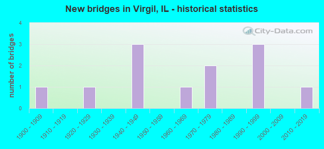
- New bridges - historical statistics
- 11900-1909
- 11920-1929
- 31940-1949
- 11960-1969
- 21970-1979
- 31990-1999
- 12010-2019
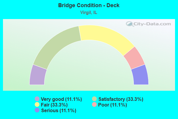
- Bridge Condition - Deck
- 11.1%Very good
- 33.3%Satisfactory
- 33.3%Fair
- 11.1%Poor
- 11.1%Serious
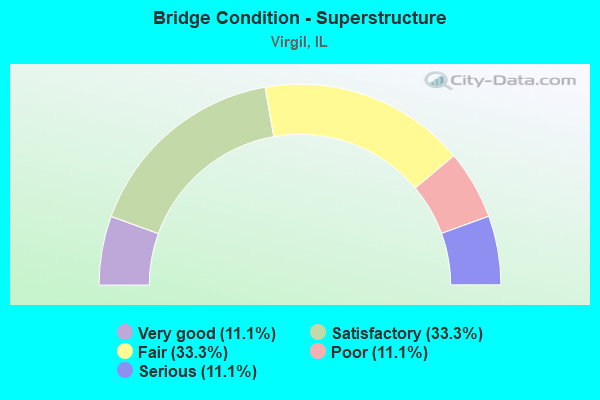
- Bridge Condition - Superstructure
- 11.1%Very good
- 33.3%Satisfactory
- 33.3%Fair
- 11.1%Poor
- 11.1%Serious
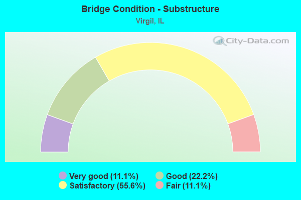
- Bridge Condition - Substructure
- 11.1%Very good
- 22.2%Good
- 55.6%Satisfactory
- 11.1%Fair
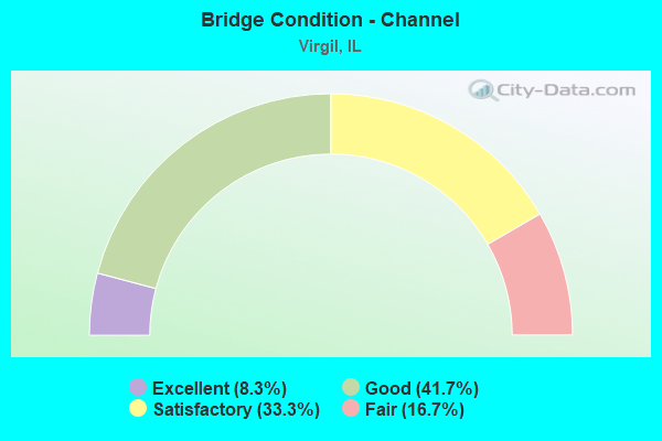
- Bridge Condition - Channel
- 8.3%Excellent
- 41.7%Good
- 33.3%Satisfactory
- 16.7%Fair
Find on map >> Show street view
Structure Number: 452012, Location: 4.2 M W OF IL 47 (Lat: 41.957981, Lng: -88.556481), Route carried "on" structure: State highway 64, Year Built: 1993, Year Reconstructed: 1994, Status: Open, Structure Length: 1.01m (3.31ft), Average Daily Traffic: 7,500 (year 2021), Truck Traffic: 8%, Average Future Daily Traffic: 8,485 (year 2032), Features Intersected: VIRGIL DITCH #3
Minimum Vertical Clearance: 30+ m (98+ ft), Kilometerpoint: 143.775, Lanes on structure: 2, Base Highway Network: Yes, Owner: State Highway Agency, Approaching Roadway Width: 12.2m (40.0ft), Material/Design: Concrete continuous, Design/Construction: Culvert, Number Of Spans In Main Unit: 3, Length of Maximum Span: 3.3m (10.8ft)
Condition: Channel: Fair, Culverts: Good, Operating Rating: 63.2 metric tons, Method Used To Determine Operating Rating: Load Factor (LF) rating reported by rating factor (RF) method using MS18 loading, Inventory Rating: 37.9 metric tons, Method Used To Determine Inventory Rating: Load Factor (LF) rating reported by rating factor (RF) method using MS18 loading, Structural Evaluation: Better than present minimum criteria, Waterway Adequacy: Better than present minimum criteria, Approach Roadway Alignment: Equal to present desirable criteria, Designated Inspection Frequency: Every 48 months, Inspection Date: December 2021
Find on map >> Show street view
Structure Number: 452013, Location: 2.8 M W OF IL 47 (Lat: 41.954067, Lng: -88.529358), Route carried "on" structure: State highway 64, Year Built: 1993, Status: Open, Structure Length: 0.82m (2.69ft), Average Daily Traffic: 6,300 (year 2021), Truck Traffic: 9%, Average Future Daily Traffic: 7,975 (year 2032), Features Intersected: VIRGIL DITCH #2
Minimum Vertical Clearance: 30+ m (98+ ft), Kilometerpoint: 145.996, Lanes on structure: 2, Base Highway Network: Yes, Owner: State Highway Agency, Approaching Roadway Width: 12.2m (40.0ft), Material/Design: Concrete continuous, Design/Construction: Culvert, Number Of Spans In Main Unit: 3, Length of Maximum Span: 2.7m (8.9ft)
Condition: Channel: Satisfactory, Culverts: Good, Operating Rating: 60.3 metric tons, Method Used To Determine Operating Rating: Load Factor (LF) rating reported by rating factor (RF) method using MS18 loading, Inventory Rating: 36.3 metric tons, Method Used To Determine Inventory Rating: Load Factor (LF) rating reported by rating factor (RF) method using MS18 loading, Structural Evaluation: Better than present minimum criteria, Waterway Adequacy: Better than present minimum criteria, Approach Roadway Alignment: Equal to present desirable criteria, Designated Inspection Frequency: Every 48 months, Inspection Date: December 2021
Find on map >> Show street view
Structure Number: 453002, Location: 0.5 MI W VIRGIL (Lat: 41.963381, Lng: -88.547053), Route carried "on" structure: Other road , Year Built: 1929, Status: Posted for load, Structure Length: 0.79m (2.59ft), Average Daily Traffic: 750 (year 2018), Truck Traffic: 9%, Average Future Daily Traffic: 766 (year 2032), Features Intersected: VIRGIL DR DITCH NO.3, Facility Carried by Structure: PEPLOW ROAD
Minimum Vertical Clearance: 30+ m (98+ ft), Kilometerpoint: 9.849, Lanes on structure: 2, Owner: County Highway Agency, Approaching Roadway Width: 7.9m (25.9ft), Skew: 2 degrees, Material/Design: Concrete, Design/Construction: Slab, Number Of Spans In Main Unit: 1, Length of Maximum Span: 7.6m (24.9ft), Curb-To-Curb Width: 7.4m (24.3ft), Out-to-Out Width: 8.0m (26.2ft)
Condition: Deck: Fair, Superstructure: Fair, Substructure: Satisfactory, Channel: Good, Operating Rating: 34.7 metric tons, Method Used To Determine Operating Rating: Load Factor (LF) rating reported by rating factor (RF) method using MS18 loading, Inventory Rating: 20.7 metric tons, Method Used To Determine Inventory Rating: Load Factor (LF) rating reported by rating factor (RF) method using MS18 loading, Structural Evaluation: Somewhat better than minimum adequacy, Deck Geometry: Meets minimum limits, Waterway Adequacy: Equal to present minimum criteria, Approach Roadway Alignment: Equal to present desirable criteria, Bridge Posting: Required (Relationship of Operating Rating to Maximum Legal Load: > 39.9% below), Designated Inspection Frequency: Every 24 months, Inspection Date: April 2021, Deck Structure Type: Concrete Cast-file-Place, Wearing Surface/Protective System: Wearing Surface: Bituminous
Find on map >> Show street view
Structure Number: 453038, Location: 1 M W MEREDITH RD (Lat: 41.938297, Lng: -88.558658), Route carried "on" structure: County highway , Year Built: 1947, Status: Posted for load, Structure Length: 0.98m (3.22ft), Average Daily Traffic: 450 (year 2018), Truck Traffic: 6%, Average Future Daily Traffic: 510 (year 2032), Design Load: H 15, Features Intersected: VIRGIL DR DITCH NO.3, Facility Carried by Structure: WINTERS ROAD
Minimum Vertical Clearance: 30+ m (98+ ft), Kilometerpoint: 3.540, Lanes on structure: 2, Owner: Town or Township Highway Agency, Approaching Roadway Width: 7.3m (24.0ft), Skew: 2 degrees, Material/Design: Concrete, Design/Construction: Slab, Number Of Spans In Main Unit: 1, Length of Maximum Span: 9.5m (31.2ft), Curb-To-Curb Width: 7.2m (23.6ft), Out-to-Out Width: 8.6m (28.2ft)
Condition: Deck: Fair, Superstructure: Fair, Substructure: Satisfactory, Channel: Fair, Operating Rating: 30.5 metric tons, Method Used To Determine Operating Rating: Load Factor (LF) rating reported by rating factor (RF) method using MS18 loading, Inventory Rating: 18.1 metric tons, Method Used To Determine Inventory Rating: Load Factor (LF) rating reported by rating factor (RF) method using MS18 loading, Structural Evaluation: Somewhat better than minimum adequacy, Deck Geometry: Meets minimum limits, Waterway Adequacy: Better than present minimum criteria, Approach Roadway Alignment: Equal to present desirable criteria, Bridge Posting: Required (Relationship of Operating Rating to Maximum Legal Load: > 39.9% below), Designated Inspection Frequency: Every 24 months, Inspection Date: April 2021, Deck Structure Type: Concrete Cast-file-Place, Wearing Surface/Protective System: Wearing Surface: Bituminous
Find on map >> Show street view
Structure Number: 453039, Location: 1.5 MI E MAPLE PARK (Lat: 41.916453, Lng: -88.549786), Route carried "on" structure: County highway , Year Built: 1962, Status: Posted for load, Structure Length: 0.95m (3.12ft), Average Daily Traffic: 100 (year 2018), Truck Traffic: 11%, Average Future Daily Traffic: 160 (year 2032), Design Load: HS 15, Features Intersected: VIRGIL DR DITCH NO.1, Facility Carried by Structure: MC NULTY ROAD
Minimum Vertical Clearance: 30+ m (98+ ft), Kilometerpoint: 0.789, Lanes on structure: 2, Owner: Town or Township Highway Agency, Approaching Roadway Width: 6.4m (21.0ft), Skew: 3 degrees, Material/Design: Prestressed concrete, Design/Construction: Box Beam or Girders - Multiple, Number Of Spans In Main Unit: 1, Length of Maximum Span: 9.1m (29.9ft), Curb-To-Curb Width: 7.3m (24.0ft), Out-to-Out Width: 7.9m (25.9ft)
Condition: Deck: Poor, Superstructure: Poor, Substructure: Fair, Channel: Satisfactory, Operating Rating: 30.5 metric tons, Method Used To Determine Operating Rating: Load Factor (LF) rating reported by rating factor (RF) method using MS18 loading, Inventory Rating: 18.1 metric tons, Method Used To Determine Inventory Rating: Load Factor (LF) rating reported by rating factor (RF) method using MS18 loading, Structural Evaluation: Meets minimum limits, Deck Geometry: Equal to present minimum criteria, Waterway Adequacy: Equal to present desirable criteria, Approach Roadway Alignment: Equal to present desirable criteria, Bridge Posting: Required (Relationship of Operating Rating to Maximum Legal Load: > 39.9% below), Designated Inspection Frequency: Every 24 months, Inspection Date: March 2021, Deck Structure Type: Concrete Precast Panels, Wearing Surface/Protective System: Wearing Surface: Bituminous
Find on map >> Show street view
Structure Number: 45304, Location: 1.0 MI S VIRGIL (Lat: 41.943106, Lng: -88.532233), Route carried "on" structure: City street , Year Built: 1949, Status: Posted for load, Structure Length: 0.92m (3.02ft), Average Future Daily Traffic: 319 (year 2032), Design Load: H 15, Features Intersected: VIRGIL DR DITCH NO.2, Facility Carried by Structure: WELTER ROAD
Minimum Vertical Clearance: 30+ m (98+ ft), Kilometerpoint: 0.435, Lanes on structure: 2, Owner: Town or Township Highway Agency, Approaching Roadway Width: 6.7m (22.0ft), Material/Design: Concrete, Design/Construction: Slab, Number Of Spans In Main Unit: 1, Length of Maximum Span: 8.7m (28.5ft), Curb-To-Curb Width: 7.3m (24.0ft), Out-to-Out Width: 8.6m (28.2ft)
Condition: Deck: Satisfactory, Superstructure: Satisfactory, Substructure: Satisfactory, Channel: Satisfactory, Operating Rating: 31.4 metric tons, Method Used To Determine Operating Rating: Load Factor (LF) rating reported by rating factor (RF) method using MS18 loading, Inventory Rating: 18.8 metric tons, Method Used To Determine Inventory Rating: Load Factor (LF) rating reported by rating factor (RF) method using MS18 loading, Structural Evaluation: Somewhat better than minimum adequacy, Deck Geometry: Equal to present minimum criteria, Waterway Adequacy: Equal to present desirable criteria, Approach Roadway Alignment: Equal to present desirable criteria, Bridge Posting: Required (Relationship of Operating Rating to Maximum Legal Load: > 39.9% below), Designated Inspection Frequency: Every 24 months, Inspection Date: March 2021, Deck Structure Type: Concrete Cast-file-Place, Wearing Surface/Protective System: Wearing Surface: Bituminous
Find on map >> Show street view
Structure Number: 453041, Location: 1.5 MI N VIRGIL (Lat: 41.981961, Lng: -88.545014), Route carried "on" structure: County highway , Year Built: 1949, Status: Posted for load, Structure Length: 0.85m (2.79ft), Average Daily Traffic: 1,000 (year 2018), Truck Traffic: 5%, Average Future Daily Traffic: 1,404 (year 2032), Design Load: H 15, Features Intersected: VIRGIL DR DITCH NO.3, Facility Carried by Structure: RAMM ROAD
Minimum Vertical Clearance: 30+ m (98+ ft), Kilometerpoint: 3.782, Lanes on structure: 2, Owner: County Highway Agency, Approaching Roadway Width: 9.4m (30.8ft), Material/Design: Concrete, Design/Construction: Slab, Number Of Spans In Main Unit: 1, Length of Maximum Span: 8.2m (26.9ft), Curb-To-Curb Width: 7.3m (24.0ft), Out-to-Out Width: 8.6m (28.2ft)
Condition: Deck: Satisfactory, Superstructure: Satisfactory, Substructure: Satisfactory, Channel: Good, Operating Rating: 32.1 metric tons, Method Used To Determine Operating Rating: Load Factor (LF) rating reported by rating factor (RF) method using MS18 loading, Inventory Rating: 19.1 metric tons, Method Used To Determine Inventory Rating: Load Factor (LF) rating reported by rating factor (RF) method using MS18 loading, Structural Evaluation: Somewhat better than minimum adequacy, Deck Geometry: Meets minimum limits, Waterway Adequacy: Equal to present desirable criteria, Approach Roadway Alignment: Equal to present desirable criteria, Bridge Posting: Required (Relationship of Operating Rating to Maximum Legal Load: > 39.9% below), Designated Inspection Frequency: Every 24 months, Inspection Date: April 2020, Deck Structure Type: Concrete Cast-file-Place, Wearing Surface/Protective System: Wearing Surface: Bituminous
Find on map >> Show street view
Structure Number: 453098, Location: .7 M E of IL64 (Lat: 41.956692, Lng: -88.529281), Route carried "on" structure: Other road , Year Built: 1974, Status: Open, Structure Length: 1.55m (5.09ft), Average Daily Traffic: 125 (year 2018), Truck Traffic: 14%, Average Future Daily Traffic: 190 (year 2032), Design Load: HS 20, Features Intersected: VIRGIL DRN DITCH #2, Facility Carried by Structure: I C TRAIL
Minimum Vertical Clearance: 30+ m (98+ ft), Kilometerpoint: 0.290, Lanes on structure: 2, Owner: City or Municipal Highway Agency, Approaching Roadway Width: 5.9m (19.4ft), Skew: 2 degrees, Material/Design: Prestressed concrete, Design/Construction: Box Beam or Girders - Multiple, Number Of Spans In Main Unit: 1, Length of Maximum Span: 15.2m (49.9ft), Curb-To-Curb Width: 8.7m (28.5ft), Out-to-Out Width: 8.9m (29.2ft)
Condition: Deck: Serious, Superstructure: Serious, Substructure: Good, Channel: Good, Operating Rating: 58.0 metric tons, Method Used To Determine Operating Rating: Load Factor (LF) rating reported by rating factor (RF) method using MS18 loading, Inventory Rating: 34.7 metric tons, Method Used To Determine Inventory Rating: Load Factor (LF) rating reported by rating factor (RF) method using MS18 loading, Structural Evaluation: High priority of corrective action, Deck Geometry: Equal to present minimum criteria, Waterway Adequacy: Equal to present desirable criteria, Approach Roadway Alignment: Equal to present desirable criteria, Designated Inspection Frequency: Every 24 months, Inspection Date: November 2020, Deck Structure Type: Concrete Precast Panels, Wearing Surface/Protective System: Wearing Surface: Bituminous, Membrane: Built-up
Find on map >> Show street view
Structure Number: 453114, Location: 0.6 MI N. IL Rte 38 (Lat: 41.907667, Lng: -88.517256), Route carried "on" structure: County highway , Year Built: 1978, Status: Open, Structure Length: 1.51m (4.95ft), Average Daily Traffic: 75 (year 2020), Truck Traffic: 40%, Average Future Daily Traffic: 96 (year 2032), Design Load: HS 20, Features Intersected: VIRGIL DITCH NO 1, Facility Carried by Structure: FRANCIS RD
Minimum Vertical Clearance: 30+ m (98+ ft), Kilometerpoint: 2.301, Lanes on structure: 2, Owner: Town or Township Highway Agency, Approaching Roadway Width: 5.8m (19.0ft), Skew: 1 degrees, Material/Design: Prestressed concrete, Design/Construction: Box Beam or Girders - Multiple, Number Of Spans In Main Unit: 1, Length of Maximum Span: 14.3m (46.9ft), Curb-To-Curb Width: 8.2m (26.9ft), Out-to-Out Width: 8.2m (26.9ft)
Condition: Deck: Fair, Superstructure: Fair, Substructure: Satisfactory, Channel: Good, Operating Rating: 60.6 metric tons, Method Used To Determine Operating Rating: Load Factor (LF) rating reported by rating factor (RF) method using MS18 loading, Inventory Rating: 36.3 metric tons, Method Used To Determine Inventory Rating: Load Factor (LF) rating reported by rating factor (RF) method using MS18 loading, Structural Evaluation: Somewhat better than minimum adequacy, Deck Geometry: Equal to present minimum criteria, Waterway Adequacy: Better than present minimum criteria, Approach Roadway Alignment: Equal to present desirable criteria, Designated Inspection Frequency: Every 24 months, Inspection Date: March 2021, Deck Structure Type: Concrete Precast Panels, Wearing Surface/Protective System: Wearing Surface: Gravel
Find on map >> Show street view
Structure Number: 453141, Location: 1.4 MI S. ILL 64 (Lat: 41.934800, Lng: -88.537122), Route carried "on" structure: County highway , Year Built: 1992, Status: Open, Structure Length: 2.05m (6.73ft), Average Daily Traffic: 1,700 (year 2018), Truck Traffic: 11%, Average Future Daily Traffic: 1,595 (year 2032), Design Load: HS 20, Features Intersected: UNION DRAI.DITCH #3, Facility Carried by Structure: MEREDITH ROAD
Minimum Vertical Clearance: 30+ m (98+ ft), Kilometerpoint: 2.333, Lanes on structure: 2, Owner: County Highway Agency, Approaching Roadway Width: 9.1m (29.9ft), Material/Design: Prestressed concrete, Design/Construction: Box Beam or Girders - Multiple, Number Of Spans In Main Unit: 1, Length of Maximum Span: 19.8m (65.0ft), Curb-To-Curb Width: 11.9m (39.0ft), Out-to-Out Width: 11.9m (39.0ft)
Condition: Deck: Satisfactory, Superstructure: Satisfactory, Substructure: Good, Channel: Good, Operating Rating: 50.9 metric tons, Method Used To Determine Operating Rating: Load Factor (LF) rating reported by rating factor (RF) method using MS18 loading, Inventory Rating: 30.5 metric tons, Method Used To Determine Inventory Rating: Load Factor (LF) rating reported by rating factor (RF) method using MS18 loading, Structural Evaluation: Equal to present minimum criteria, Deck Geometry: Equal to present minimum criteria, Waterway Adequacy: Equal to present desirable criteria, Approach Roadway Alignment: Equal to present desirable criteria, Designated Inspection Frequency: Every 24 months, Inspection Date: January 2020, Deck Structure Type: Concrete Precast Panels, Wearing Surface/Protective System: Wearing Surface: Bituminous, Membrane: Built-up
Find on map >> Show street view
Structure Number: 455001, Location: 3 MI E. MAPLE PARK (Lat: 41.903303, Lng: -88.536767), Route carried "on" structure: County highway , Year Built: 1900, Status: Open, Structure Length: 0.74m (2.43ft), Average Daily Traffic: 1,300 (year 2018), Truck Traffic: 15%, Average Future Daily Traffic: 1,595 (year 2032), Features Intersected: VIRGIL DD NO 1, Facility Carried by Structure: MEREDITH ROAD
Minimum Vertical Clearance: 30+ m (98+ ft), Kilometerpoint: 5.777, Lanes on structure: 2, Owner: County Highway Agency, Approaching Roadway Width: 12.2m (40.0ft), Skew: 3 degrees, Material/Design: Concrete, Design/Construction: Culvert, Number Of Spans In Main Unit: 2, Length of Maximum Span: 3.5m (11.5ft), Curb-To-Curb Width: 10.9m (35.8ft), Out-to-Out Width: 11.6m (38.1ft)
Condition: Channel: Satisfactory, Culverts: Good, Operating Rating: 40.5 metric tons, Method Used To Determine Operating Rating: Field evaluation and documented engineering judgment, Inventory Rating: 24.3 metric tons, Method Used To Determine Inventory Rating: Field evaluation and documented engineering judgment, Structural Evaluation: Equal to present minimum criteria, Deck Geometry: Equal to present minimum criteria, Waterway Adequacy: Equal to present minimum criteria, Approach Roadway Alignment: Equal to present desirable criteria, Designated Inspection Frequency: Every 24 months, Inspection Date: April 2021
Find on map >> Show street view
Structure Number: 455543, Location: .5 MI N RAMM RD (Lat: 41.989278, Lng: -88.547475), Route carried "on" structure: Other road , Year Built: 2019, Status: Open, Structure Length: 2.19m (7.19ft), Average Daily Traffic: 775 (year 2018), Truck Traffic: 19%, Average Future Daily Traffic: 1,170 (year 2038), Design Load: HS 25 or greater, Features Intersected: TRIB VIRGIL DITCH 3, Facility Carried by Structure: PEPLOW RD
Minimum Vertical Clearance: 30+ m (98+ ft), Kilometerpoint: 7.017, Lanes on structure: 2, Owner: County Highway Agency, Approaching Roadway Width: 9.8m (32.2ft), Skew: 2 degrees, Material/Design: Concrete continuous, Design/Construction: Slab, Number Of Spans In Main Unit: 3, Length of Maximum Span: 8.2m (26.9ft), Curb-To-Curb Width: 9.8m (32.2ft), Out-to-Out Width: 10.7m (35.1ft)
Condition: Deck: Very good, Superstructure: Very good, Substructure: Very good, Channel: Excellent, Operating Rating: 40.5 metric tons, Method Used To Determine Operating Rating: Load and Resistance Factor Rating (LRFR) rating reported by rating factor(RF) method using HL-93 loadings, Inventory Rating: 31.1 metric tons, Method Used To Determine Inventory Rating: Load and Resistance Factor Rating (LRFR) rating reported by rating factor(RF) method using HL-93 loadings, Structural Evaluation: Better than present minimum criteria, Deck Geometry: Equal to present minimum criteria, Waterway Adequacy: Superior to present desirable criteria, Approach Roadway Alignment: Equal to present desirable criteria, Designated Inspection Frequency: Every 48 months, Inspection Date: March 2021, Deck Structure Type: Concrete Cast-file-Place, Wearing Surface/Protective System: Deck Protection: Epoxy Coated Reinforcing