Bridge Statistics for Warrensville Heights, Ohio (OH)
Condition, Traffic, Stress, Structural Evaluation, Project Costs
- National Bridge Inventory (NBI) Statistics
- 45Number of bridges
- 774ft / 236mTotal length
- $4,060,000Total costs
- 1,881,231Total average daily traffic
- 155,680Total average daily truck traffic
- National Bridge Inventory (NBI) Registered Bridges for Warrensville Heights
- No street view available for this location
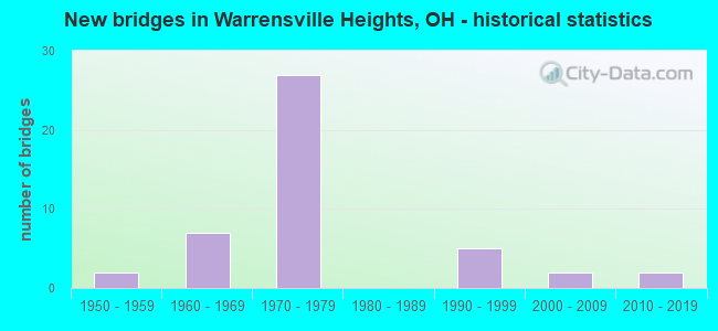
- New bridges - historical statistics
- 21950-1959
- 71960-1969
- 271970-1979
- 51990-1999
- 22000-2009
- 22010-2019
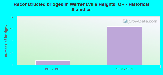
- Reconstructed bridges - Historical Statistics
- 11980-1989
- 81990-1999
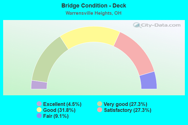
- Bridge Condition - Deck
- 4.5%Excellent
- 27.3%Very good
- 31.8%Good
- 27.3%Satisfactory
- 9.1%Fair
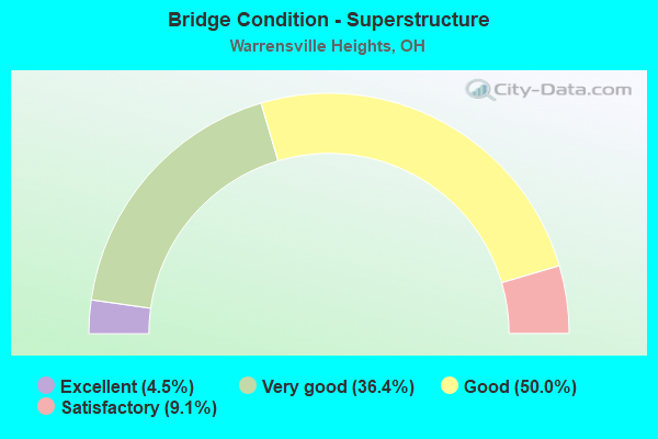
- Bridge Condition - Superstructure
- 4.5%Excellent
- 36.4%Very good
- 50.0%Good
- 9.1%Satisfactory
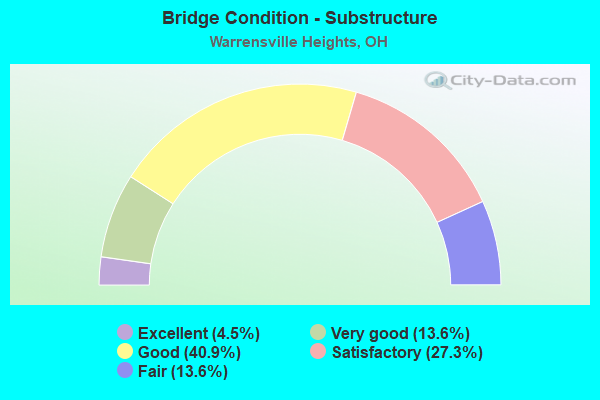
- Bridge Condition - Substructure
- 4.5%Excellent
- 13.6%Very good
- 40.9%Good
- 27.3%Satisfactory
- 13.6%Fair
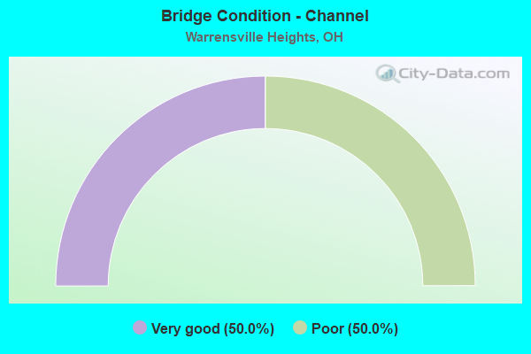
- Bridge Condition - Channel
- 50.0%Very good
- 50.0%Poor
Find on map >> Show street view
Structure Number: 1803484, Location: .5 MI W NORTHFIELD RD (Lat: 41.429331, Lng: -81.536189), Route carried "on" structure: County highway 4, Year Built: 1959, Year Reconstructed: 1991, Status: Open, Structure Length: 4.51m (14.80ft), Average Daily Traffic: 32,922 (year 2016), Truck Traffic: 3%, Average Future Daily Traffic: 45,696 (year 2036), Design Load: H 20, Features Intersected: CUY-43-0942 Warrensville
Minimum Vertical Clearance: 30+ m (98+ ft), Kilometerpoint: 4.088, Lanes on structure: 4, Lanes under structure: 4, Owner: State Highway Agency, Approaching Roadway Width: 15.9m (52.2ft), Material/Design: Steel continuous, Design/Construction: Stringer/Multi-beam, Number Of Spans In Main Unit: 3, Length of Maximum Span: 24.4m (80.1ft), Curb or Sidewalk Widths: Left: 1.2m (3.9ft), Right: 1.2m (3.9ft), Curb-To-Curb Width: 15.9m (52.2ft), Out-to-Out Width: 18.3m (60.0ft)
Condition: Deck: Satisfactory, Superstructure: Satisfactory, Substructure: Fair, Operating Rating: 55.1 metric tons, Method Used To Determine Operating Rating: Load Factor (LF) rating reported by rating factor (RF) method using MS18 loading, Inventory Rating: 32.4 metric tons, Method Used To Determine Inventory Rating: Load Factor (LF) rating reported by rating factor (RF) method using MS18 loading, Structural Evaluation: Somewhat better than minimum adequacy, Deck Geometry: Meets minimum limits, Underclear: Equal to present minimum criteria, Approach Roadway Alignment: Equal to present desirable criteria, Length Of Structure Improvement: 6.10m (20.01ft), Designated Inspection Frequency: Every 12 months, Inspection Date: November 2021, Bridge Improvement Cost: $770,000, Roadway Improvement Cost: $90,000, Total Project Cost: $860,000, Deck Structure Type: Concrete Cast-file-Place, Wearing Surface/Protective System: Wearing Surface: Latex Concrete, Deck Protection: Epoxy Coated Reinforcing
Find on map >> Show street view
Structure Number: 1811088, Location: JCT. I-271 WITH I-480N (Lat: 41.428639, Lng: -81.508211), Route carried "on" structure: Interstate 480N, Year Built: 1972, Status: Open, Structure Length: 21.28m (69.82ft), Average Daily Traffic: 49,927 (year 2015), Truck Traffic: 11%, Average Future Daily Traffic: 69,299 (year 2035), Design Load: HS 20+Mod, Features Intersected: IR 271,422WB TO GO 271SB
Minimum Vertical Clearance: 30+ m (98+ ft), Kilometerpoint: 2.076, Lanes on structure: 4, Lanes under structure: 4, Base Highway Network: Yes, Owner: State Highway Agency, Approaching Roadway Width: 16.2m (53.1ft), Skew: 4 degrees, Material/Design: Steel continuous, Design/Construction: Stringer/Multi-beam, Number Of Spans In Main Unit: 8, Length of Maximum Span: 33.5m (109.9ft), Curb-To-Curb Width: 16.2m (53.1ft), Out-to-Out Width: 17.1m (56.1ft)
Condition: Deck: Fair, Superstructure: Good, Substructure: Satisfactory, Operating Rating: 42.1 metric tons, Method Used To Determine Operating Rating: Load Factor (LF) rating reported by rating factor (RF) method using MS18 loading, Inventory Rating: 32.4 metric tons, Method Used To Determine Inventory Rating: Load Factor (LF) rating reported by rating factor (RF) method using MS18 loading, Structural Evaluation: Equal to present minimum criteria, Deck Geometry: Meets minimum limits, Underclear: Meets minimum limits, Approach Roadway Alignment: Equal to present desirable criteria, Designated Inspection Frequency: Every 12 months, Inspection Date: September 2021, Deck Structure Type: Concrete Cast-file-Place, Wearing Surface/Protective System: Wearing Surface: Monolithic Concrete
Find on map >> Show street view
Structure Number: 1811096, Location: JCT. I-271 WITH I-480N (Lat: 41.430119, Lng: -81.504919), Route carried "on" structure: Ramp US 422, Year Built: 1974, Year Reconstructed: 1998, Status: Open, Structure Length: 14.36m (47.11ft), Average Daily Traffic: 56,435 (year 2000), Truck Traffic: 9%, Average Future Daily Traffic: 78,332 (year 2020), Design Load: HS 20+Mod, Features Intersected: IR 271, Facility Carried by Structure: IR 480N W.B.
Minimum Vertical Clearance: 30+ m (98+ ft), Kilometerpoint: 21.726, Lanes on structure: 2, Lanes under structure: 4, Owner: State Highway Agency, Approaching Roadway Width: 16.2m (53.1ft), Skew: 5 degrees, Material/Design: Steel continuous, Design/Construction: Stringer/Multi-beam, Number Of Spans In Main Unit: 4, Length of Maximum Span: 40.5m (132.9ft), Curb-To-Curb Width: 16.5m (54.1ft), Out-to-Out Width: 17.1m (56.1ft)
Condition: Deck: Good, Superstructure: Good, Substructure: Satisfactory, Operating Rating: 42.1 metric tons, Method Used To Determine Operating Rating: Allowable Stress (AS) rating reported by rating factor (RF) method using MS18 loading, Inventory Rating: 32.4 metric tons, Method Used To Determine Inventory Rating: Allowable Stress (AS) rating reported by rating factor (RF) method using MS18 loading, Structural Evaluation: Equal to present minimum criteria, Deck Geometry: Superior to present desirable criteria, Underclear: Meets minimum limits, Approach Roadway Alignment: Equal to present desirable criteria, Designated Inspection Frequency: Every 12 months, Inspection Date: November 2021, Deck Structure Type: Concrete Cast-file-Place, Wearing Surface/Protective System: Wearing Surface: Monolithic Concrete
Find on map >> Show street view
Structure Number: 1811118, Location: 1.38 MI. N. OF JCT. SR-43 (Lat: 41.433189, Lng: -81.503111), Route carried "on" structure: US 422, Year Built: 1974, Year Reconstructed: 1995, Status: Open, Structure Length: 18.68m (61.29ft), Average Daily Traffic: 8,038 (year 2015), Truck Traffic: 3%, Average Future Daily Traffic: 11,157 (year 2035), Features Intersected: IR 271, 271X, Facility Carried by Structure: RAMP NE
Minimum Vertical Clearance: 30+ m (98+ ft), Kilometerpoint: 21.694, Lanes on structure: 1, Lanes under structure: 6, Base Highway Network: Yes, Owner: State Highway Agency, Approaching Roadway Width: 7.9m (25.9ft), Skew: 9 degrees, Material/Design: Steel continuous, Design/Construction: Stringer/Multi-beam, Number Of Spans In Main Unit: 6, Length of Maximum Span: 33.5m (109.9ft), Curb-To-Curb Width: 9.1m (29.9ft), Out-to-Out Width: 10.2m (33.5ft)
Condition: Deck: Very good, Superstructure: Very good, Substructure: Very good, Operating Rating: 42.1 metric tons, Method Used To Determine Operating Rating: Load Factor (LF) rating reported by rating factor (RF) method using MS18 loading, Inventory Rating: 32.4 metric tons, Method Used To Determine Inventory Rating: Load Factor (LF) rating reported by rating factor (RF) method using MS18 loading, Structural Evaluation: Equal to present desirable criteria, Deck Geometry: Meets minimum limits, Underclear: High priority of corrective action, Approach Roadway Alignment: Equal to present desirable criteria, Designated Inspection Frequency: Every 24 months, Inspection Date: December 2021, Deck Structure Type: Concrete Cast-file-Place, Wearing Surface/Protective System: Wearing Surface: Monolithic Concrete, Deck Protection: Epoxy Coated Reinforcing
Find on map >> Show street view
Structure Number: 1811134, Location: .16 MI. S. OF JCT. SR-175 (Lat: 41.435131, Lng: -81.501469), Route carried "on" structure: County highway C0085, Year Built: 1965, Year Reconstructed: 1999, Status: Open, Structure Length: 19.90m (65.29ft), Average Daily Traffic: 10,270 (year 2015), Truck Traffic: 5%, Average Future Daily Traffic: 14,255 (year 2035), Design Load: HS 20+Mod, Features Intersected: IR271&271X (CUY-271-6.10, Facility Carried by Structure: EMERY RD
Minimum Vertical Clearance: 30+ m (98+ ft), Kilometerpoint: 1.609, Lanes on structure: 4, Lanes under structure: 4, Owner: State Highway Agency, Approaching Roadway Width: 18.3m (60.0ft), Skew: 3 degrees, Material/Design: Steel continuous, Design/Construction: Stringer/Multi-beam, Number Of Spans In Main Unit: 8, Length of Maximum Span: 28.7m (94.2ft), Curb or Sidewalk Widths: Left: 1.3m (4.3ft), Right: 1.3m (4.3ft), Curb-To-Curb Width: 15.9m (52.2ft), Out-to-Out Width: 19.1m (62.7ft)
Condition: Deck: Satisfactory, Superstructure: Satisfactory, Substructure: Fair, Operating Rating: 51.8 metric tons, Method Used To Determine Operating Rating: Load and Resistance Factor Rating (LRFR) rating reported by rating factor(RF) method using HL-93 loadings, Inventory Rating: 38.9 metric tons, Method Used To Determine Inventory Rating: Load and Resistance Factor Rating (LRFR) rating reported by rating factor(RF) method using HL-93 loadings, Structural Evaluation: Somewhat better than minimum adequacy, Deck Geometry: Meets minimum limits, Underclear: Somewhat better than minimum adequacy, Approach Roadway Alignment: Equal to present desirable criteria, Designated Inspection Frequency: Every 12 months, Inspection Date: April 2021, Deck Structure Type: Concrete Cast-file-Place, Wearing Surface/Protective System: Wearing Surface: Monolithic Concrete
Find on map >> Show street view
Structure Number: 1811169, Location: JCT. SR-175 WITH I-480 (Lat: 41.436489, Lng: -81.497731), Route carried "on" structure: State highway 175, Year Built: 1965, Year Reconstructed: 1998, Status: Open, Structure Length: 25.38m (83.27ft), Average Daily Traffic: 12,634 (year 2015), Truck Traffic: 7%, Average Future Daily Traffic: 17,536 (year 2035), Design Load: H 20, Features Intersected: IR 271,IR 480N TOGO 271B
Minimum Vertical Clearance: 30+ m (98+ ft), Kilometerpoint: 4.506, Lanes on structure: 2, Lanes under structure: 6, Owner: State Highway Agency, Approaching Roadway Width: 13.7m (44.9ft), Skew: 5 degrees, Material/Design: Steel continuous, Design/Construction: Stringer/Multi-beam, Number Of Spans In Main Unit: 6, Length of Maximum Span: 60.7m (199.1ft), Curb or Sidewalk Widths: Left: 1.3m (4.3ft), Right: 1.3m (4.3ft), Curb-To-Curb Width: 8.5m (27.9ft), Out-to-Out Width: 11.8m (38.7ft)
Condition: Deck: Good, Superstructure: Good, Substructure: Satisfactory, Operating Rating: 42.1 metric tons, Method Used To Determine Operating Rating: Load Factor (LF) rating reported by rating factor (RF) method using MS18 loading, Inventory Rating: 32.4 metric tons, Method Used To Determine Inventory Rating: Load Factor (LF) rating reported by rating factor (RF) method using MS18 loading, Structural Evaluation: Equal to present minimum criteria, Deck Geometry: Meets minimum limits, Underclear: High priority of corrective action, Approach Roadway Alignment: Equal to present desirable criteria, Length Of Structure Improvement: 23.59m (77.40ft), Designated Inspection Frequency: Every 12 months, Inspection Date: November 2021, Bridge Improvement Cost: $2,880,000, Roadway Improvement Cost: $320,000, Total Project Cost: $3,200,000, Deck Structure Type: Concrete Cast-file-Place, Wearing Surface/Protective System: Wearing Surface: Monolithic Concrete, Membrane: Epoxy
Find on map >> Show street view
Structure Number: 1813625, Location: .94 MI. W. OF JCT. SR-8 (Lat: 41.424531, Lng: -81.545361), Route carried "on" structure: City street CAMDN, Year Built: 1971, Status: Open, Structure Length: 5.70m (18.70ft), Average Daily Traffic: 1,000 (year 2002), Average Future Daily Traffic: 219,512 (year 2022), Design Load: H 15, Features Intersected: IR 480, Facility Carried by Structure: CAMDEN RD
Minimum Vertical Clearance: 30+ m (98+ ft), Kilometerpoint: 0.000, Lanes on structure: 2, Lanes under structure: 10, Owner: State Highway Agency, Approaching Roadway Width: 8.5m (27.9ft), Material/Design: Steel continuous, Design/Construction: Stringer/Multi-beam, Number Of Spans In Main Unit: 2, Length of Maximum Span: 28.7m (94.2ft), Curb or Sidewalk Widths: Left: 1.2m (3.9ft), Right: 1.2m (3.9ft), Curb-To-Curb Width: 8.5m (27.9ft), Out-to-Out Width: 11.7m (38.4ft)
Condition: Deck: Fair, Superstructure: Good, Substructure: Satisfactory, Operating Rating: 48.6 metric tons, Method Used To Determine Operating Rating: Load Factor (LF) rating reported by rating factor (RF) method using MS18 loading, Inventory Rating: 29.2 metric tons, Method Used To Determine Inventory Rating: Load Factor (LF) rating reported by rating factor (RF) method using MS18 loading, Structural Evaluation: Equal to present minimum criteria, Deck Geometry: Somewhat better than minimum adequacy, Underclear: High priority of corrective action, Approach Roadway Alignment: Equal to present desirable criteria, Designated Inspection Frequency: Every 12 months, Inspection Date: December 2021, Deck Structure Type: Concrete Cast-file-Place, Wearing Surface/Protective System: Wearing Surface: Monolithic Concrete
Find on map >> Show street view
Structure Number: 1813684, Location: .52 MI. W. OF JCT. SR-8 (Lat: 41.424400, Lng: -81.537339), Route carried "on" structure: County highway 4, Year Built: 2012, Status: Open, Structure Length: 8.37m (27.46ft), Average Daily Traffic: 23,469 (year 2015), Truck Traffic: 7%, Average Future Daily Traffic: 32,575 (year 2035), Design Load: HL 93, Features Intersected: CUY-480-2386, Facility Carried by Structure: WRRNSVLL CNTR RD
Minimum Vertical Clearance: 30+ m (98+ ft), Kilometerpoint: 3.520, Lanes on structure: 6, Lanes under structure: 10, Owner: State Highway Agency, Approaching Roadway Width: 23.2m (76.1ft), Material/Design: Steel continuous, Design/Construction: Stringer/Multi-beam, Number Of Spans In Main Unit: 2, Length of Maximum Span: 41.1m (134.8ft), Curb or Sidewalk Widths: Left: 1.5m (4.9ft), Right: 1.5m (4.9ft), Curb-To-Curb Width: 23.2m (76.1ft), Out-to-Out Width: 26.8m (87.9ft)
Condition: Deck: Excellent, Superstructure: Excellent, Substructure: Excellent, Operating Rating: 64.8 metric tons, Method Used To Determine Operating Rating: Load Factor (LF) rating reported by rating factor (RF) method using MS18 loading, Inventory Rating: 38.9 metric tons, Method Used To Determine Inventory Rating: Load Factor (LF) rating reported by rating factor (RF) method using MS18 loading, Structural Evaluation: Superior to present desirable criteria, Deck Geometry: Meets minimum limits, Underclear: High priority of corrective action, Approach Roadway Alignment: Equal to present desirable criteria, Designated Inspection Frequency: Every 24 months, Inspection Date: December 2021, Deck Structure Type: Concrete Cast-file-Place, Wearing Surface/Protective System: Wearing Surface: Monolithic Concrete, Membrane: Epoxy, Deck Protection: Epoxy Coated Reinforcing
Find on map >> Show street view
Structure Number: 1814494, Location: JCT. SR-8 WITH I-480N (Lat: 41.424219, Lng: -81.529161), Route carried "on" structure: Interstate 480N, Year Built: 1971, Year Reconstructed: 1998, Status: Open, Structure Length: 26.52m (87.01ft), Average Daily Traffic: 85,274 (year 2015), Truck Traffic: 11%, Average Future Daily Traffic: 118,360 (year 2035), Design Load: HS 20+Mod, Features Intersected: SR-8 (NORTHFIELD)&480 WB
Minimum Vertical Clearance: 30+ m (98+ ft), Kilometerpoint: 0.177, Lanes on structure: 4, Lanes under structure: 10, Base Highway Network: Yes, Owner: State Highway Agency, Approaching Roadway Width: 37.0m (121.4ft), Skew: 19 degrees, Material/Design: Steel continuous, Design/Construction: Stringer/Multi-beam, Number Of Spans In Main Unit: 8, Length of Maximum Span: 44.5m (146.0ft), Curb-To-Curb Width: 37.0m (121.4ft), Out-to-Out Width: 38.9m (127.6ft)
Condition: Deck: Very good, Superstructure: Good, Substructure: Good, Operating Rating: 42.1 metric tons, Method Used To Determine Operating Rating: Allowable Stress (AS) rating reported by rating factor (RF) method using MS18 loading, Inventory Rating: 32.4 metric tons, Method Used To Determine Inventory Rating: Allowable Stress (AS) rating reported by rating factor (RF) method using MS18 loading, Structural Evaluation: Better than present minimum criteria, Deck Geometry: Superior to present desirable criteria, Underclear: Meets minimum limits, Approach Roadway Alignment: Equal to present desirable criteria, Designated Inspection Frequency: Every 24 months, Inspection Date: December 2021, Deck Structure Type: Concrete Cast-file-Place, Wearing Surface/Protective System: Wearing Surface: Integral Concrete
Find on map >> Show street view
Structure Number: 181454, Location: .65 MI. E. OF. JCT. SR-8 (Lat: 41.426211, Lng: -81.517039), Route carried "on" structure: Interstate 480N, Year Built: 1974, Year Reconstructed: 1998, Status: Open, Structure Length: 5.21m (17.09ft), Average Daily Traffic: 40,218 (year 2015), Truck Traffic: 11%, Average Future Daily Traffic: 55,823 (year 2035), Design Load: HS 20+Mod, Features Intersected: CR 14 (GREEN RD)
Minimum Vertical Clearance: 30+ m (98+ ft), Kilometerpoint: 1.223, Lanes on structure: 2, Lanes under structure: 2, Base Highway Network: Yes, Owner: State Highway Agency, Approaching Roadway Width: 14.6m (47.9ft), Skew: 2 degrees, Material/Design: Steel continuous, Design/Construction: Stringer/Multi-beam, Number Of Spans In Main Unit: 3, Length of Maximum Span: 21.0m (68.9ft), Curb-To-Curb Width: 16.2m (53.1ft), Out-to-Out Width: 23.0m (75.5ft)
Condition: Deck: Satisfactory, Superstructure: Very good, Substructure: Good, Operating Rating: 51.8 metric tons, Method Used To Determine Operating Rating: Load and Resistance Factor Rating (LRFR) rating reported by rating factor(RF) method using HL-93 loadings, Inventory Rating: 38.9 metric tons, Method Used To Determine Inventory Rating: Load and Resistance Factor Rating (LRFR) rating reported by rating factor(RF) method using HL-93 loadings, Structural Evaluation: Better than present minimum criteria, Deck Geometry: Superior to present desirable criteria, Underclear: Equal to present minimum criteria, Approach Roadway Alignment: Equal to present desirable criteria, Designated Inspection Frequency: Every 12 months, Inspection Date: June 2021, Deck Structure Type: Concrete Cast-file-Place, Wearing Surface/Protective System: Wearing Surface: Monolithic Concrete
Find on map >> Show street view
Structure Number: 1814559, Location: .65 MI. E. OF JCT. SR-8 (Lat: 41.425981, Lng: -81.517031), Route carried "on" structure: Interstate 480N, Year Built: 1974, Status: Open, Structure Length: 5.18m (16.99ft), Average Daily Traffic: 40,218 (year 2015), Truck Traffic: 11%, Average Future Daily Traffic: 55,823 (year 2035), Design Load: HS 20+Mod, Features Intersected: CR 14 (GREEN RD)
Minimum Vertical Clearance: 30+ m (98+ ft), Kilometerpoint: 1.223, Lanes on structure: 3, Lanes under structure: 2, Base Highway Network: Yes, Owner: State Highway Agency, Approaching Roadway Width: 13.4m (44.0ft), Skew: 2 degrees, Material/Design: Steel continuous, Design/Construction: Stringer/Multi-beam, Number Of Spans In Main Unit: 3, Length of Maximum Span: 21.0m (68.9ft), Curb-To-Curb Width: 18.4m (60.4ft), Out-to-Out Width: 19.2m (63.0ft)
Condition: Deck: Good, Superstructure: Very good, Substructure: Good, Operating Rating: 42.1 metric tons, Method Used To Determine Operating Rating: Allowable Stress (AS) rating reported by rating factor (RF) method using MS18 loading, Inventory Rating: 32.4 metric tons, Method Used To Determine Inventory Rating: Allowable Stress (AS) rating reported by rating factor (RF) method using MS18 loading, Structural Evaluation: Better than present minimum criteria, Deck Geometry: Equal to present desirable criteria, Underclear: Somewhat better than minimum adequacy, Approach Roadway Alignment: Equal to present desirable criteria, Designated Inspection Frequency: Every 24 months, Inspection Date: June 2021, Deck Structure Type: Concrete Cast-file-Place, Wearing Surface/Protective System: Wearing Surface: Monolithic Concrete
Find on map >> Show street view
Structure Number: 1814575, Location: .43 MI. E. OF JCT. SR-8 (Lat: 41.424750, Lng: -81.521261), Route carried "on" structure: Interstate 480N, Year Built: 1974, Year Reconstructed: 1998, Status: Open, Structure Length: 7.65m (25.10ft), Average Daily Traffic: 73,586 (year 2015), Truck Traffic: 11%, Average Future Daily Traffic: 102,137 (year 2035), Design Load: HS 20+Mod, Features Intersected: CR-11 (MILES RD)
Minimum Vertical Clearance: 30+ m (98+ ft), Kilometerpoint: 0.869, Lanes on structure: 5, Lanes under structure: 6, Base Highway Network: Yes, Owner: State Highway Agency, Approaching Roadway Width: 41.1m (134.8ft), Skew: 13 degrees, Material/Design: Steel continuous, Design/Construction: Stringer/Multi-beam, Number Of Spans In Main Unit: 4, Length of Maximum Span: 23.8m (78.1ft), Curb-To-Curb Width: 41.1m (134.8ft), Out-to-Out Width: 43.3m (142.1ft)
Condition: Deck: Very good, Superstructure: Good, Substructure: Good, Operating Rating: 42.1 metric tons, Method Used To Determine Operating Rating: Allowable Stress (AS) rating reported by rating factor (RF) method using MS18 loading, Inventory Rating: 32.4 metric tons, Method Used To Determine Inventory Rating: Allowable Stress (AS) rating reported by rating factor (RF) method using MS18 loading, Structural Evaluation: Better than present minimum criteria, Deck Geometry: Superior to present desirable criteria, Underclear: High priority of corrective action, Approach Roadway Alignment: Equal to present desirable criteria, Designated Inspection Frequency: Every 24 months, Inspection Date: December 2021, Deck Structure Type: Concrete Cast-file-Place, Wearing Surface/Protective System: Wearing Surface: Monolithic Concrete
Find on map >> Show street view
Structure Number: 1814591, Location: AT 480N/422/271 INTERCHAN (Lat: 41.429250, Lng: -81.507439), Route carried "on" structure: Ramp Interstate 480N, Year Built: 1997, Status: Open, Structure Length: 24.88m (81.63ft), Average Daily Traffic: 112,870 (year 2000), Truck Traffic: 9%, Average Future Daily Traffic: 156,664 (year 2020), Design Load: HS 20+Mod, Features Intersected: IR271SB &422WB togo 480N
Minimum Vertical Clearance: 30+ m (98+ ft), Kilometerpoint: 2.189, Lanes on structure: 2, Lanes under structure: 4, Owner: State Highway Agency, Approaching Roadway Width: 14.6m (47.9ft), Skew: 9 degrees, Material/Design: Steel continuous, Design/Construction: Stringer/Multi-beam, Number Of Spans In Main Unit: 7, Length of Maximum Span: 38.1m (125.0ft), Curb-To-Curb Width: 14.6m (47.9ft), Out-to-Out Width: 15.7m (51.5ft)
Condition: Deck: Good, Superstructure: Good, Substructure: Good, Operating Rating: 42.1 metric tons, Method Used To Determine Operating Rating: Load Factor (LF) rating reported by rating factor (RF) method using MS18 loading, Inventory Rating: 32.4 metric tons, Method Used To Determine Inventory Rating: Load Factor (LF) rating reported by rating factor (RF) method using MS18 loading, Structural Evaluation: Better than present minimum criteria, Deck Geometry: Superior to present desirable criteria, Underclear: High priority of corrective action, Approach Roadway Alignment: Equal to present desirable criteria, Designated Inspection Frequency: Every 12 months, Critical Feature Inspection Frequency: Every 24 months, Inspection Date: July 2021, Critical Feature Inspection Date: July 2021, Deck Structure Type: Concrete Cast-file-Place, Wearing Surface/Protective System: Wearing Surface: Monolithic Concrete, Deck Protection: Epoxy Coated Reinforcing
Find on map >> Show street view
Structure Number: 1814613, Location: 480N & 271 & 422 INTERCHG (Lat: 41.430369, Lng: -81.506119), Route carried "on" structure: Ramp Interstate 271X, Year Built: 1998, Status: Open, Structure Length: 16.98m (55.71ft), Average Daily Traffic: 112,870 (year 2000), Truck Traffic: 9%, Average Future Daily Traffic: 156,664 (year 2020), Design Load: HS 20+Mod, Features Intersected: IR 271SB (271XSB TO 480)
Minimum Vertical Clearance: 30+ m (98+ ft), Kilometerpoint: 9.350, Lanes on structure: 2, Lanes under structure: 2, Owner: State Highway Agency, Approaching Roadway Width: 14.6m (47.9ft), Material/Design: Steel continuous, Design/Construction: Stringer/Multi-beam, Number Of Spans In Main Unit: 5, Length of Maximum Span: 36.6m (120.1ft), Curb-To-Curb Width: 14.6m (47.9ft), Out-to-Out Width: 15.7m (51.5ft)
Condition: Deck: Good, Superstructure: Very good, Substructure: Good, Operating Rating: 42.1 metric tons, Method Used To Determine Operating Rating: Load Factor (LF) rating reported by rating factor (RF) method using MS18 loading, Inventory Rating: 32.4 metric tons, Method Used To Determine Inventory Rating: Load Factor (LF) rating reported by rating factor (RF) method using MS18 loading, Structural Evaluation: Better than present minimum criteria, Deck Geometry: Superior to present desirable criteria, Underclear: Somewhat better than minimum adequacy, Approach Roadway Alignment: Equal to present minimum criteria, Designated Inspection Frequency: Every 12 months, Critical Feature Inspection Frequency: Every 24 months, Inspection Date: December 2021, Critical Feature Inspection Date: June 2020, Deck Structure Type: Concrete Cast-file-Place, Wearing Surface/Protective System: Wearing Surface: Monolithic Concrete, Deck Protection: Epoxy Coated Reinforcing
Find on map >> Show street view
Structure Number: 1814664, Location: 0.21M W RICHMOND RD (Lat: 41.430569, Lng: -81.502381), Route carried "on" structure: US 422, Year Built: 1971, Status: Open, Structure Length: 8.23m (27.00ft), Average Daily Traffic: 8,038 (year 2015), Truck Traffic: 3%, Average Future Daily Traffic: 11,157 (year 2035), Design Load: HS 20+Mod, Features Intersected: 422W RMP TOGO 480N W/271
Minimum Vertical Clearance: 30+ m (98+ ft), Kilometerpoint: 21.968, Lanes on structure: 1, Lanes under structure: 2, Base Highway Network: Yes, Owner: State Highway Agency, Approaching Roadway Width: 8.5m (27.9ft), Material/Design: Steel continuous, Design/Construction: Stringer/Multi-beam, Number Of Spans In Main Unit: 3, Length of Maximum Span: 35.1m (115.2ft), Curb-To-Curb Width: 7.9m (25.9ft), Out-to-Out Width: 9.3m (30.5ft)
Condition: Deck: Good, Superstructure: Very good, Substructure: Good, Operating Rating: 42.1 metric tons, Method Used To Determine Operating Rating: Load Factor (LF) rating reported by rating factor (RF) method using MS18 loading, Inventory Rating: 32.4 metric tons, Method Used To Determine Inventory Rating: Load Factor (LF) rating reported by rating factor (RF) method using MS18 loading, Structural Evaluation: Better than present minimum criteria, Deck Geometry: High priority of corrective action, Underclear: Equal to present minimum criteria, Approach Roadway Alignment: Equal to present desirable criteria, Designated Inspection Frequency: Every 24 months, Inspection Date: May 2021, Deck Structure Type: Concrete Cast-file-Place, Wearing Surface/Protective System: Wearing Surface: Integral Concrete
Find on map >> Show street view
Structure Number: 181468, Location: .34 MI. E. OF I-271 (Lat: 41.430489, Lng: -81.501989), Route carried "on" structure: Ramp US 422, Year Built: 1971, Year Reconstructed: 1998, Status: Open, Structure Length: 5.00m (16.40ft), Average Daily Traffic: 13,440 (year 2001), Truck Traffic: 6%, Average Future Daily Traffic: 18,655 (year 2021), Design Load: HS 20+Mod, Features Intersected: UP 422EB,DN 480N TOGO 27, Facility Carried by Structure: IR 480N
Minimum Vertical Clearance: 4.55m (14.93ft), Kilometerpoint: 21.951, Lanes on structure: 2, Lanes under structure: 1, Owner: State Highway Agency, Approaching Roadway Width: 11.6m (38.1ft), Skew: 4 degrees, Material/Design: Steel continuous, Design/Construction: Stringer/Multi-beam, Number Of Spans In Main Unit: 3, Length of Maximum Span: 18.6m (61.0ft), Curb-To-Curb Width: 11.9m (39.0ft), Out-to-Out Width: 13.2m (43.3ft)
Condition: Deck: Very good, Superstructure: Very good, Substructure: Good, Operating Rating: 42.1 metric tons, Method Used To Determine Operating Rating: Allowable Stress (AS) rating reported by rating factor (RF) method using MS18 loading, Inventory Rating: 32.4 metric tons, Method Used To Determine Inventory Rating: Allowable Stress (AS) rating reported by rating factor (RF) method using MS18 loading, Structural Evaluation: Better than present minimum criteria, Deck Geometry: High priority of corrective action, Underclear: Meets minimum limits, Approach Roadway Alignment: Equal to present desirable criteria, Designated Inspection Frequency: Every 24 months, Inspection Date: May 2021, Deck Structure Type: Concrete Cast-file-Place, Wearing Surface/Protective System: Wearing Surface: Monolithic Concrete
Find on map >> Show street view
Structure Number: 1814745, Location: OVER SR 175 (Lat: 41.429400, Lng: -81.497881), Route carried "on" structure: US 422, Year Built: 1971, Status: Open, Structure Length: 4.42m (14.50ft), Average Daily Traffic: 8,038 (year 2015), Truck Traffic: 3%, Average Future Daily Traffic: 11,157 (year 2035), Design Load: HS 20+Mod, Features Intersected: SR 175 (RICHMOND RD)
Minimum Vertical Clearance: 30+ m (98+ ft), Kilometerpoint: 22.370, Lanes on structure: 2, Lanes under structure: 2, Base Highway Network: Yes, Owner: State Highway Agency, Approaching Roadway Width: 4.9m (16.1ft), Skew: 1 degrees, Material/Design: Steel continuous, Design/Construction: Stringer/Multi-beam, Number Of Spans In Main Unit: 3, Length of Maximum Span: 21.6m (70.9ft), Curb-To-Curb Width: 7.9m (25.9ft), Out-to-Out Width: 9.3m (30.5ft)
Condition: Deck: Satisfactory, Superstructure: Good, Substructure: Fair, Operating Rating: 42.1 metric tons, Method Used To Determine Operating Rating: Allowable Stress (AS) rating reported by rating factor (RF) method using MS18 loading, Inventory Rating: 32.4 metric tons, Method Used To Determine Inventory Rating: Allowable Stress (AS) rating reported by rating factor (RF) method using MS18 loading, Structural Evaluation: Somewhat better than minimum adequacy, Deck Geometry: High priority of replacement, Underclear: Meets minimum limits, Approach Roadway Alignment: Equal to present desirable criteria, Designated Inspection Frequency: Every 12 months, Inspection Date: Febuary 2021, Deck Structure Type: Concrete Cast-file-Place, Wearing Surface/Protective System: Wearing Surface: Integral Concrete
Find on map >> Show street view
Structure Number: 1814753, Location: 0.4 MI. EAST OF JCT I-271 (Lat: 41.429250, Lng: -81.497869), Route carried "on" structure: Ramp Interstate 480N, Year Built: 1971, Status: Open, Structure Length: 4.33m (14.21ft), Average Daily Traffic: 6,475 (year 2000), Truck Traffic: 3%, Average Future Daily Traffic: 8,987 (year 2020), Design Load: HS 20+Mod, Features Intersected: SR 175 (RICHMOND RD), Facility Carried by Structure: IR 480
Minimum Vertical Clearance: 30+ m (98+ ft), Kilometerpoint: 2.253, Lanes on structure: 2, Lanes under structure: 2, Owner: State Highway Agency, Approaching Roadway Width: 7.3m (24.0ft), Material/Design: Steel continuous, Design/Construction: Stringer/Multi-beam, Number Of Spans In Main Unit: 3, Length of Maximum Span: 21.3m (69.9ft), Curb-To-Curb Width: 11.9m (39.0ft), Out-to-Out Width: 13.2m (43.3ft)
Condition: Deck: Satisfactory, Superstructure: Good, Substructure: Satisfactory, Operating Rating: 42.1 metric tons, Method Used To Determine Operating Rating: Allowable Stress (AS) rating reported by rating factor (RF) method using MS18 loading, Inventory Rating: 32.4 metric tons, Method Used To Determine Inventory Rating: Allowable Stress (AS) rating reported by rating factor (RF) method using MS18 loading, Structural Evaluation: Equal to present minimum criteria, Deck Geometry: Superior to present desirable criteria, Underclear: Meets minimum limits, Approach Roadway Alignment: Equal to present desirable criteria, Designated Inspection Frequency: Every 12 months, Inspection Date: Febuary 2021, Deck Structure Type: Concrete Cast-file-Place, Wearing Surface/Protective System: Wearing Surface: Integral Concrete
Find on map >> Show street view
Structure Number: 1814788, Location: 0.4 MI. EAST OF JCT I-271 (Lat: 41.429781, Lng: -81.497861), Route carried "on" structure: US 422, Year Built: 1971, Status: Open, Structure Length: 4.66m (15.29ft), Average Daily Traffic: 8,038 (year 2015), Truck Traffic: 3%, Average Future Daily Traffic: 11,157 (year 2035), Design Load: HS 20+Mod, Features Intersected: SR 175(02.35)RICHMOND RD
Minimum Vertical Clearance: 30+ m (98+ ft), Kilometerpoint: 22.370, Lanes on structure: 2, Lanes under structure: 2, Base Highway Network: Yes, Owner: State Highway Agency, Approaching Roadway Width: 13.4m (44.0ft), Skew: 1 degrees, Material/Design: Steel continuous, Design/Construction: Stringer/Multi-beam, Number Of Spans In Main Unit: 3, Length of Maximum Span: 22.3m (73.2ft), Curb-To-Curb Width: 19.2m (63.0ft), Out-to-Out Width: 20.1m (65.9ft)
Condition: Deck: Satisfactory, Superstructure: Good, Substructure: Satisfactory, Operating Rating: 42.1 metric tons, Method Used To Determine Operating Rating: Allowable Stress (AS) rating reported by rating factor (RF) method using MS18 loading, Inventory Rating: 32.4 metric tons, Method Used To Determine Inventory Rating: Allowable Stress (AS) rating reported by rating factor (RF) method using MS18 loading, Structural Evaluation: Equal to present minimum criteria, Deck Geometry: Superior to present desirable criteria, Underclear: Meets minimum limits, Approach Roadway Alignment: Equal to present desirable criteria, Designated Inspection Frequency: Every 12 months, Inspection Date: Febuary 2021, Deck Structure Type: Concrete Cast-file-Place, Wearing Surface/Protective System: Wearing Surface: Integral Concrete
Find on map >> Show street view
Structure Number: 183012, Location: 400 FT SOUTH OF MILES RD (Lat: 41.428611, Lng: -81.536381), Route carried "on" structure: County highway 4, Year Built: 2008, Status: Open, Structure Length: 2.45m (8.04ft), Average Daily Traffic: 24,645 (year 2015), Truck Traffic: 7%, Average Future Daily Traffic: 34,207 (year 2035), Design Load: HS 25 or greater, Features Intersected: NORFOLK SOUTHERN RAILROA
Minimum Vertical Clearance: 30+ m (98+ ft), Kilometerpoint: 3.991, Lanes on structure: 4, Owner: County Highway Agency, Approaching Roadway Width: 15.9m (52.2ft), Skew: 1 degrees, Material/Design: Prestressed concrete, Design/Construction: Box Beam or Girders - Multiple, Number Of Spans In Main Unit: 1, Length of Maximum Span: 22.9m (75.1ft), Curb or Sidewalk Widths: Left: 1.8m (5.9ft), Right: 1.8m (5.9ft), Curb-To-Curb Width: 15.9m (52.2ft), Out-to-Out Width: 20.1m (65.9ft)
Condition: Deck: Very good, Superstructure: Very good, Substructure: Very good, Operating Rating: 54.4 metric tons, Method Used To Determine Operating Rating: Load and Resistance Factor Rating (LRFR) rating reported by rating factor(RF) method using HL-93 loadings, Inventory Rating: 41.8 metric tons, Method Used To Determine Inventory Rating: Load and Resistance Factor Rating (LRFR) rating reported by rating factor(RF) method using HL-93 loadings, Structural Evaluation: Equal to present desirable criteria, Deck Geometry: Meets minimum limits, Underclear: Equal to present desirable criteria, Approach Roadway Alignment: Equal to present desirable criteria, Designated Inspection Frequency: Every 24 months, Inspection Date: September 2021, Deck Structure Type: Concrete Cast-file-Place, Wearing Surface/Protective System: Wearing Surface: Monolithic Concrete, Deck Protection: Epoxy Coated Reinforcing
Find on map >> Show street view
Structure Number: 1834053, Location: 464' SO OF HARVARD RD (Lat: 41.447169, Lng: -81.536119), Route carried "on" structure: County highway 4, Year Built: 1962, Status: Open, Structure Length: 0.87m (2.85ft), Average Daily Traffic: 16,415 (year 2015), Truck Traffic: 7%, Average Future Daily Traffic: 22,784 (year 2035), Design Load: HS 20, Features Intersected: MILL CREEK, Facility Carried by Structure: WARRENSVILLE
Minimum Vertical Clearance: 30+ m (98+ ft), Kilometerpoint: 6.035, Lanes on structure: 4, Owner: County Highway Agency, Approaching Roadway Width: 15.9m (52.2ft), Material/Design: Concrete, Design/Construction: Frame, Number Of Spans In Main Unit: 1, Length of Maximum Span: 8.3m (27.2ft), Curb or Sidewalk Widths: Left: 1.5m (4.9ft), Right: 1.5m (4.9ft), Curb-To-Curb Width: 15.9m (52.2ft), Out-to-Out Width: 24.4m (80.1ft)
Condition: Deck: Good, Superstructure: Good, Substructure: Good, Channel: Very good, Operating Rating: 42.1 metric tons, Method Used To Determine Operating Rating: Load Factor (LF) rating reported by rating factor (RF) method using MS18 loading, Inventory Rating: 25.9 metric tons, Method Used To Determine Inventory Rating: Load Factor (LF) rating reported by rating factor (RF) method using MS18 loading, Structural Evaluation: Equal to present minimum criteria, Deck Geometry: Meets minimum limits, Waterway Adequacy: Superior to present desirable criteria, Approach Roadway Alignment: Equal to present desirable criteria, Designated Inspection Frequency: Every 24 months, Inspection Date: September 2021, Deck Structure Type: Concrete Cast-file-Place, Wearing Surface/Protective System: Wearing Surface: Monolithic Concrete
Find on map >> Show street view
Structure Number: 1834177, Location: 1135' E OF NORTHFIELD RD. (Lat: 41.435139, Lng: -81.521939), Route carried "on" structure: County highway C0085, Year Built: 2008, Status: Open, Structure Length: 1.22m (4.00ft), Average Daily Traffic: 10,270 (year 2015), Truck Traffic: 5%, Average Future Daily Traffic: 14,255 (year 2035), Design Load: HS 25 or greater, Features Intersected: BEAR CREEK, Facility Carried by Structure: EMERY ROAD CR 85
Minimum Vertical Clearance: 30+ m (98+ ft), Kilometerpoint: 1.915, Lanes on structure: 4, Owner: County Highway Agency, Approaching Roadway Width: 15.9m (52.2ft), Material/Design: Prestressed concrete, Design/Construction: Box Beam or Girders - Multiple, Number Of Spans In Main Unit: 1, Length of Maximum Span: 11.9m (39.0ft), Curb or Sidewalk Widths: Left: 4.0m (13.1ft), Right: 4.0m (13.1ft), Curb-To-Curb Width: 15.9m (52.2ft), Out-to-Out Width: 24.4m (80.1ft)
Condition: Deck: Very good, Superstructure: Very good, Substructure: Very good, Channel: Poor, Operating Rating: 3.0 metric tons, Method Used To Determine Operating Rating: Load Factor (LF), Structural Evaluation: High priority of corrective action, Deck Geometry: Meets minimum limits, Waterway Adequacy: Equal to present desirable criteria, Approach Roadway Alignment: Equal to present desirable criteria, Designated Inspection Frequency: Every 24 months, Inspection Date: July 2021, Deck Structure Type: Concrete Cast-file-Place, Wearing Surface/Protective System: Wearing Surface: Monolithic Concrete, Deck Protection: Epoxy Coated Reinforcing
Find on map >> Show street view
Structure Number: 1803484, Location: .5 MI W NORTHFIELD RD (Lat: 41.429331, Lng: -81.536189), Route carried "under" structure: State highway 43, Year Built: 1959, Structure Length: 0. m, Average Daily Traffic: 13,210 (year 2016), Truck Traffic: 5%, Features Intersected: CR-4 WARRENSVILLE CTR RD, Facility Carried by Structure: CR-4
Minimum Vertical Clearance: 4.60m (15.09ft), Kilometerpoint: 15.120, Lanes on structure: 4, Lanes under structure: 4, Material/Design: Steel continuous, Design/Construction: Stringer/Multi-beam, Length of Maximum Span: 24.4m (80.1ft)
Find on map >> Show street view
Structure Number: 1811088, Location: JCT. I-271 WITH I-480N (Lat: 41.428639, Lng: -81.508211), Route carried "under" structure: Interstate 271, Year Built: 1972, Structure Length: 0. m, Average Daily Traffic: 58,885 (year 2015), Truck Traffic: 8%, Features Intersected: I480N EB, Facility Carried by Structure: IR 480N E.B.
Minimum Vertical Clearance: 5.36m (17.59ft), Kilometerpoint: 8.948, Lanes on structure: 4, Lanes under structure: 4, Material/Design: Steel continuous, Design/Construction: Stringer/Multi-beam, Length of Maximum Span: 33.5m (109.9ft)
Find on map >> Show street view
Structure Number: 1811096, Location: JCT. I-271 WITH I-480N (Lat: 41.430119, Lng: -81.504919), Route carried "under" structure: Interstate 271, Year Built: 1974, Structure Length: 0. m, Average Daily Traffic: 58,885 (year 2015), Truck Traffic: 8%, Features Intersected: 422WB TOGO 480N WB,271SB, Facility Carried by Structure: IR 480N W.B.
Minimum Vertical Clearance: 5.11m (16.77ft), Kilometerpoint: 9.061, Lanes on structure: 2, Lanes under structure: 4, Material/Design: Steel continuous, Design/Construction: Stringer/Multi-beam, Length of Maximum Span: 40.5m (132.9ft)
Find on map >> Show street view
Structure Number: 1811118, Location: 1.38 MI. N. OF JCT. SR-43 (Lat: 41.433189, Lng: -81.503111), Route carried "under" structure: Interstate 271X, Year Built: 1974, Structure Length: 0. m, Features Intersected: US 422 EB, Facility Carried by Structure: RAMP NE
Minimum Vertical Clearance: 6.30m (20.67ft), Kilometerpoint: 9.350, Lanes on structure: 1, Lanes under structure: 6, Material/Design: Steel continuous, Design/Construction: Stringer/Multi-beam, Length of Maximum Span: 33.5m (109.9ft)
Find on map >> Show street view
Structure Number: 1811118, Location: 1.38 MI. N. OF JCT. SR-43 (Lat: 41.433189, Lng: -81.503111), Route carried "under" structure: Interstate 271, Year Built: 1974, Structure Length: 0. m, Average Daily Traffic: 47,872 (year 2015), Truck Traffic: 9%, Features Intersected: US 422 EB, Facility Carried by Structure: RAMP NE
Minimum Vertical Clearance: 7.39m (24.25ft), Kilometerpoint: 9.350, Lanes on structure: 1, Lanes under structure: 6, Material/Design: Steel continuous, Design/Construction: Stringer/Multi-beam, Length of Maximum Span: 33.5m (109.9ft)
Find on map >> Show street view
Structure Number: 1811134, Location: .16 MI. S. OF JCT. SR-175 (Lat: 41.435131, Lng: -81.501469), Route carried "under" structure: Interstate 271X, Year Built: 1965, Structure Length: 0. m, Average Daily Traffic: 145,430 (year 2010), Truck Traffic: 10%, Features Intersected: CR-85 (Emery Rd.), Facility Carried by Structure: EMERY RD
Minimum Vertical Clearance: 5.75m (18.86ft), Kilometerpoint: 9.817, Lanes on structure: 4, Lanes under structure: 4, Material/Design: Steel continuous, Design/Construction: Stringer/Multi-beam, Length of Maximum Span: 28.7m (94.2ft)
Find on map >> Show street view
Structure Number: 1811134, Location: .16 MI. S. OF JCT. SR-175 (Lat: 41.435131, Lng: -81.501469), Route carried "under" structure: Interstate 271, Year Built: 1965, Structure Length: 0. m, Average Daily Traffic: 47,872 (year 2015), Truck Traffic: 9%, Features Intersected: CR-85 (Emery Rd.), Facility Carried by Structure: EMERY RD
Minimum Vertical Clearance: 5.75m (18.86ft), Kilometerpoint: 9.817, Lanes on structure: 4, Lanes under structure: 4, Material/Design: Steel continuous, Design/Construction: Stringer/Multi-beam, Length of Maximum Span: 28.7m (94.2ft)
Find on map >> Show street view
Structure Number: 1811169, Location: JCT. SR-175 WITH I-480 (Lat: 41.436489, Lng: -81.497731), Route carried "under" structure: Interstate 271, Year Built: 1965, Structure Length: 0. m, Average Daily Traffic: 176,423 (year 2015), Truck Traffic: 9%, Features Intersected: SR-175 (RICHMOND RD), Facility Carried by Structure: SR 175 RICHMOND RD
Minimum Vertical Clearance: 5.23m (17.16ft), Kilometerpoint: 10.074, Lanes on structure: 2, Lanes under structure: 6, Material/Design: Steel continuous, Design/Construction: Stringer/Multi-beam, Length of Maximum Span: 60.7m (199.1ft)
Find on map >> Show street view
Structure Number: 1811169, Location: JCT. SR-175 WITH I-480 (Lat: 41.436489, Lng: -81.497731), Route carried "under" structure: Interstate 271X, Year Built: 1965, Structure Length: 0. m, Features Intersected: SR-175 (RICHMOND RD), Facility Carried by Structure: SR 175 RICHMOND RD
Minimum Vertical Clearance: 5.23m (17.16ft), Kilometerpoint: 10.074, Lanes on structure: 2, Lanes under structure: 6, Material/Design: Steel continuous, Design/Construction: Stringer/Multi-beam, Length of Maximum Span: 60.7m (199.1ft)
Find on map >> Show street view
Structure Number: 1813625, Location: .94 MI. W. OF JCT. SR-8 (Lat: 41.424531, Lng: -81.545361), Route carried "under" structure: Interstate 480, Year Built: 1971, Structure Length: 0. m, Average Daily Traffic: 158,150 (year 2015), Truck Traffic: 7%, Features Intersected: CAMDEN RD, Facility Carried by Structure: CAMDEN RD
Minimum Vertical Clearance: 5.11m (16.77ft), Kilometerpoint: 37.723, Lanes on structure: 2, Lanes under structure: 10, Material/Design: Steel continuous, Design/Construction: Stringer/Multi-beam, Length of Maximum Span: 28.7m (94.2ft)
Find on map >> Show street view
Structure Number: 1813684, Location: .52 MI. W. OF JCT. SR-8 (Lat: 41.424400, Lng: -81.537339), Route carried "under" structure: Interstate 480, Year Built: 2012, Structure Length: 0. m, Average Daily Traffic: 140,097 (year 2016), Truck Traffic: 5%, Features Intersected: CUY-480-2386, Facility Carried by Structure: WRRNSVLL CNTR RD
Minimum Vertical Clearance: 5.28m (17.32ft), Kilometerpoint: 38.399, Lanes on structure: 6, Lanes under structure: 10, Material/Design: Steel continuous, Design/Construction: Stringer/Multi-beam, Length of Maximum Span: 41.1m (134.8ft)
Find on map >> Show street view
Structure Number: 1814494, Location: JCT. SR-8 WITH I-480N (Lat: 41.424219, Lng: -81.529161), Route carried "under" structure: Interstate 480, Year Built: 1971, Structure Length: 0. m, Average Daily Traffic: 41,681 (year 2015), Truck Traffic: 8%, Features Intersected: I-480N (CUY-480N-0011)
Minimum Vertical Clearance: 4.90m (16.08ft), Kilometerpoint: 39.188, Lanes on structure: 4, Lanes under structure: 10, Material/Design: Steel continuous, Design/Construction: Stringer/Multi-beam, Length of Maximum Span: 44.5m (146.0ft)
Find on map >> Show street view
Structure Number: 181454, Location: .65 MI. E. OF. JCT. SR-8 (Lat: 41.426211, Lng: -81.517039), Route carried "under" structure: County highway 14, Year Built: 1974, Structure Length: 0. m, Average Daily Traffic: 10,617 (year 2015), Truck Traffic: 9%, Features Intersected: I-480N, Facility Carried by Structure: IR 480N W.B.
Minimum Vertical Clearance: 4.67m (15.32ft), Kilometerpoint: 77.281, Lanes on structure: 2, Lanes under structure: 2, Material/Design: Steel continuous, Design/Construction: Stringer/Multi-beam, Length of Maximum Span: 21.0m (68.9ft)
Find on map >> Show street view
Structure Number: 1814559, Location: .65 MI. E. OF JCT. SR-8 (Lat: 41.425981, Lng: -81.517031), Route carried "under" structure: County highway 14, Year Built: 1974, Structure Length: 0. m, Average Daily Traffic: 10,617 (year 2015), Truck Traffic: 9%, Features Intersected: I-480N, Facility Carried by Structure: IR 480N E.B.
Minimum Vertical Clearance: 4.40m (14.44ft), Kilometerpoint: 77.265, Lanes on structure: 3, Lanes under structure: 2, Material/Design: Steel continuous, Design/Construction: Stringer/Multi-beam, Length of Maximum Span: 21.0m (68.9ft)
Find on map >> Show street view
Structure Number: 1814575, Location: .43 MI. E. OF JCT. SR-8 (Lat: 41.424750, Lng: -81.521261), Route carried "under" structure: City street 11, Year Built: 1974, Structure Length: 0. m, Average Daily Traffic: 9,018 (year 2015), Truck Traffic: 7%, Features Intersected: I-480N, Facility Carried by Structure: IR 480N
Minimum Vertical Clearance: 4.75m (15.58ft), Kilometerpoint: 77.265, Lanes on structure: 5, Lanes under structure: 6, Material/Design: Steel continuous, Design/Construction: Stringer/Multi-beam, Length of Maximum Span: 23.8m (78.1ft)
Find on map >> Show street view
Structure Number: 1814591, Location: AT 480N/422/271 INTERCHAN (Lat: 41.429250, Lng: -81.507439), Route carried "under" structure: Interstate 271, Year Built: 1997, Structure Length: 0. m, Average Daily Traffic: 58,885 (year 2015), Truck Traffic: 8%, Features Intersected: IR480N EB TOGO IR271X NB
Minimum Vertical Clearance: 5.15m (16.90ft), Kilometerpoint: 9.109, Lanes on structure: 2, Lanes under structure: 4, Material/Design: Steel continuous, Design/Construction: Stringer/Multi-beam, Length of Maximum Span: 38.1m (125.0ft)
Find on map >> Show street view
Structure Number: 1814591, Location: AT 480N/422/271 INTERCHAN (Lat: 41.429250, Lng: -81.507439), Route carried "under" structure: Ramp US 422, Year Built: 1997, Structure Length: 0. m, Average Daily Traffic: 14,530 (year 2010), Truck Traffic: 4%, Features Intersected: US 422 WB TOGO IR 480N W, Facility Carried by Structure: 480N NB-I271X NB
Minimum Vertical Clearance: 5.41m (17.75ft), Kilometerpoint: 22.273, Lanes on structure: 2, Lanes under structure: 4, Material/Design: Steel continuous, Design/Construction: Stringer/Multi-beam, Length of Maximum Span: 38.1m (125.0ft)
Find on map >> Show street view
Structure Number: 1814613, Location: 480N & 271 & 422 INTERCHG (Lat: 41.430369, Lng: -81.506119), Route carried "under" structure: Interstate 271, Year Built: 1998, Structure Length: 0. m, Average Daily Traffic: 58,885 (year 2015), Truck Traffic: 8%, Features Intersected: IR 480N FROM IR 271B SB
Minimum Vertical Clearance: 4.93m (16.17ft), Kilometerpoint: 9.093, Lanes on structure: 2, Lanes under structure: 2, Material/Design: Steel continuous, Design/Construction: Stringer/Multi-beam, Length of Maximum Span: 36.6m (120.1ft)
Find on map >> Show street view
Structure Number: 1814664, Location: 0.21M W RICHMOND RD (Lat: 41.430569, Lng: -81.502381), Route carried "under" structure: Ramp US 422, Year Built: 1971, Structure Length: 0. m, Features Intersected: US 422 EB
Minimum Vertical Clearance: 4.55m (14.93ft), Kilometerpoint: 21.951, Lanes on structure: 1, Lanes under structure: 2, Material/Design: Steel continuous, Design/Construction: Stringer/Multi-beam, Length of Maximum Span: 35.1m (115.2ft)
Find on map >> Show street view
Structure Number: 181468, Location: .34 MI. E. OF I-271 (Lat: 41.430489, Lng: -81.501989), Route carried "under" structure: Interstate 480N, Year Built: 1971, Structure Length: 0. m, Average Daily Traffic: 19,419 (year 2015), Truck Traffic: 11%, Features Intersected: US-422
Minimum Vertical Clearance: 5.01m (16.44ft), Kilometerpoint: 2.639, Lanes on structure: 2, Lanes under structure: 1, Material/Design: Steel continuous, Design/Construction: Stringer/Multi-beam, Length of Maximum Span: 18.6m (61.0ft)
Find on map >> Show street view
Structure Number: 1814745, Location: OVER SR 175 (Lat: 41.429400, Lng: -81.497881), Route carried "under" structure: State highway 175, Year Built: 1971, Structure Length: 0. m, Average Daily Traffic: 18,555 (year 2015), Truck Traffic: 7%, Features Intersected: I-271SB RAMP TO 422F EB, Facility Carried by Structure: USR 422
Minimum Vertical Clearance: 4.90m (16.08ft), Kilometerpoint: 3.750, Lanes on structure: 2, Lanes under structure: 2, Material/Design: Steel continuous, Design/Construction: Stringer/Multi-beam, Length of Maximum Span: 21.6m (70.9ft)
Find on map >> Show street view
Structure Number: 1814753, Location: 0.4 MI. EAST OF JCT I-271 (Lat: 41.429250, Lng: -81.497869), Route carried "under" structure: State highway 175, Year Built: 1971, Structure Length: 0. m, Average Daily Traffic: 18,555 (year 2015), Truck Traffic: 7%, Features Intersected: US 422 EB, Facility Carried by Structure: IR 480
Minimum Vertical Clearance: 4.94m (16.21ft), Kilometerpoint: 3.734, Lanes on structure: 2, Lanes under structure: 2, Material/Design: Steel continuous, Design/Construction: Stringer/Multi-beam, Length of Maximum Span: 21.3m (69.9ft)
Find on map >> Show street view
Structure Number: 1814788, Location: 0.4 MI. EAST OF JCT I-271 (Lat: 41.429781, Lng: -81.497861), Route carried "under" structure: State highway 175, Year Built: 1971, Structure Length: 0. m, Average Daily Traffic: 18,555 (year 2015), Truck Traffic: 7%, Features Intersected: US 422 WB, Facility Carried by Structure: USR 422
Minimum Vertical Clearance: 5.01m (16.44ft), Kilometerpoint: 3.782, Lanes on structure: 2, Lanes under structure: 2, Material/Design: Steel continuous, Design/Construction: Stringer/Multi-beam, Length of Maximum Span: 22.3m (73.2ft)