Bridge Statistics for Warsaw, Kentucky (KY)
Condition, Traffic, Stress, Structural Evaluation, Project Costs
- National Bridge Inventory (NBI) Statistics
- 10Number of bridges
- 377ft / 115mTotal length
- $6,278,000Total costs
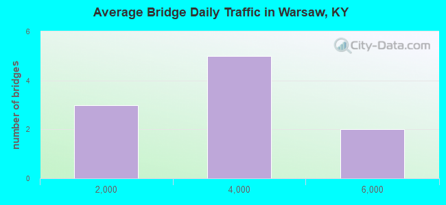
- 28,865Total average daily traffic
- 2,317Total average daily truck traffic
- National Bridge Inventory (NBI) Registered Bridges for Warsaw
- No street view available for this location
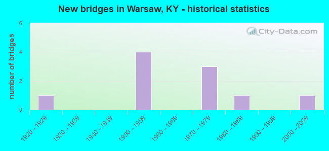
- New bridges - historical statistics
- 11920-1929
- 41950-1959
- 31970-1979
- 11980-1989
- 12000-2009
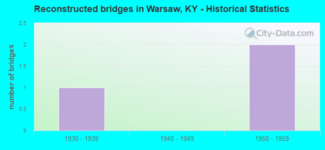
- Reconstructed bridges - Historical Statistics
- 11930-1939
- 01940-1949
- 21950-1959
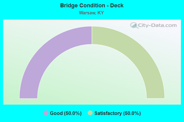
- Bridge Condition - Deck
- 50.0%Good
- 50.0%Satisfactory
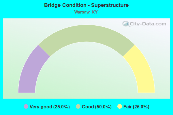
- Bridge Condition - Superstructure
- 25.0%Very good
- 50.0%Good
- 25.0%Fair
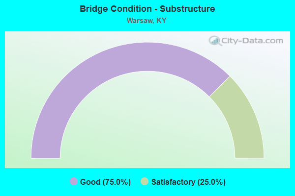
- Bridge Condition - Substructure
- 75.0%Good
- 25.0%Satisfactory
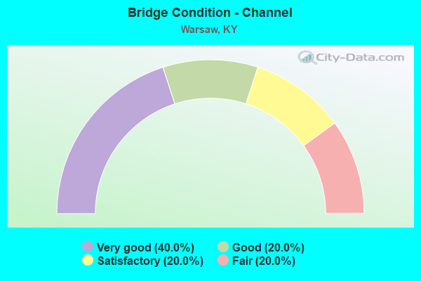
- Bridge Condition - Channel
- 40.0%Very good
- 20.0%Good
- 20.0%Satisfactory
- 20.0%Fair
Find on map >> Show street view
Structure Number: 39B00001N, Location: 2.4 MI WEST OF JCT US 127 (Lat: 38.784167, Lng: -84.851944), Route carried "on" structure: US 42, Year Built: 1929, Year Reconstructed: 1943, Status: Open, Structure Length: 0.73m (2.40ft), Average Daily Traffic: 3,875 (year 2019), Truck Traffic: 6%, Average Future Daily Traffic: 3,410 (year 2039), Design Load: H 15, Features Intersected: STERMANS BRANCH
Minimum Vertical Clearance: 30+ m (98+ ft), Kilometerpoint: 15.453, Lanes on structure: 2, Owner: State Highway Agency, Approaching Roadway Width: 5.5m (18.0ft), Material/Design: Concrete, Design/Construction: Culvert, Number Of Spans In Main Unit: 2, Length of Maximum Span: 3.2m (10.5ft)
Condition: Culverts: Satisfactory, Structural Evaluation: Equal to present minimum criteria, Approach Roadway Alignment: Equal to present desirable criteria, Designated Inspection Frequency: Every 24 months, Underwater Inspection Frequency: Every 60 months, Inspection Date: June 2021, Underwater Inspection Date: June 2021
Find on map >> Show street view
Structure Number: 39B00009N, Location: .20 MI N.E. OF JCT KY 455 (Lat: 38.771389, Lng: -84.898889), Route carried "on" structure: State highway 35, Year Built: 1956, Status: Posted for load, Structure Length: 0.94m (3.08ft), Average Daily Traffic: 3,055 (year 2015), Truck Traffic: 8%, Average Future Daily Traffic: 2,535 (year 2035), Design Load: H 20, Features Intersected: DRY CREEK
Minimum Vertical Clearance: 30+ m (98+ ft), Kilometerpoint: 12.477, Lanes on structure: 2, Base Highway Network: Yes, Owner: State Highway Agency, Approaching Roadway Width: 6.1m (20.0ft), Material/Design: Concrete, Design/Construction: Culvert, Number Of Spans In Main Unit: 2, Length of Maximum Span: 4.3m (14.1ft)
Condition: Channel: Fair, Culverts: Satisfactory, Operating Rating: 39.0 metric tons, Method Used To Determine Operating Rating: Field evaluation and documented engineering judgment, Inventory Rating: 18.1 metric tons, Method Used To Determine Inventory Rating: Field evaluation and documented engineering judgment, Structural Evaluation: Somewhat better than minimum adequacy, Waterway Adequacy: Better than present minimum criteria, Approach Roadway Alignment: Equal to present minimum criteria, Bridge Posting: Required (Relationship of Operating Rating to Maximum Legal Load: > 39.9% below), Designated Inspection Frequency: Every 24 months, Inspection Date: July 2021
Find on map >> Show street view
Structure Number: 39B00019N, Location: .10 MI WEST OF JCT KY 35 (Lat: 38.754444, Lng: -84.915278), Route carried "on" structure: State highway 1130, Year Built: 1951, Year Reconstructed: 1961, Status: Open, Structure Length: 1.11m (3.64ft), Average Daily Traffic: 131 (year 2018), Average Future Daily Traffic: 115 (year 2038), Design Load: HS 20, Features Intersected: CRUZ BRANCH CREEK
Minimum Vertical Clearance: 30+ m (98+ ft), Kilometerpoint: 7.479, Lanes on structure: 2, Owner: State Highway Agency, Approaching Roadway Width: 4.9m (16.1ft), Skew: 3 degrees, Material/Design: Concrete, Design/Construction: Culvert, Number Of Spans In Main Unit: 2, Length of Maximum Span: 5.0m (16.4ft), Curb-To-Curb Width: 6.7m (22.0ft), Out-to-Out Width: 7.3m (24.0ft)
Condition: Culverts: Satisfactory, Operating Rating: 63.0 metric tons, Method Used To Determine Operating Rating: Load Factor (LF), Inventory Rating: 37.9 metric tons, Method Used To Determine Inventory Rating: Load Factor (LF), Structural Evaluation: Equal to present minimum criteria, Deck Geometry: Meets minimum limits, Approach Roadway Alignment: Equal to present minimum criteria, Designated Inspection Frequency: Every 24 months, Underwater Inspection Frequency: Every 60 months, Inspection Date: June 2021, Underwater Inspection Date: June 2021
Find on map >> Show street view
Structure Number: 39B00020N, Location: .30 MI WEST OF JCT KY 35 (Lat: 38.752500, Lng: -84.917778), Route carried "on" structure: State highway 1130, Year Built: 1951, Year Reconstructed: 1961, Status: Posted for load, Structure Length: 0.96m (3.15ft), Average Daily Traffic: 131 (year 2018), Average Future Daily Traffic: 115 (year 2038), Design Load: HS 20, Features Intersected: CRAIGS CREEK
Minimum Vertical Clearance: 30+ m (98+ ft), Kilometerpoint: 7.149, Lanes on structure: 2, Owner: State Highway Agency, Approaching Roadway Width: 4.9m (16.1ft), Material/Design: Concrete, Design/Construction: Culvert, Number Of Spans In Main Unit: 2, Length of Maximum Span: 4.4m (14.4ft)
Condition: Culverts: Satisfactory, Operating Rating: 20.0 metric tons, Method Used To Determine Operating Rating: Field evaluation and documented engineering judgment, Inventory Rating: 20.0 metric tons, Method Used To Determine Inventory Rating: Field evaluation and documented engineering judgment, Structural Evaluation: Somewhat better than minimum adequacy, Approach Roadway Alignment: Somewhat better than minimum adequacy, Bridge Posting: Required (Relationship of Operating Rating to Maximum Legal Load: > 39.9% below), Designated Inspection Frequency: Every 24 months, Underwater Inspection Frequency: Every 60 months, Inspection Date: June 2021, Underwater Inspection Date: June 2021
Find on map >> Show street view
Structure Number: 39B00022N, Location: 1.2 MI SOU. OF JCT US 42 (Lat: 38.752500, Lng: -84.972778), Route carried "on" structure: State highway 184, Year Built: 1956, Status: Posted for load, Structure Length: 1.98m (6.50ft), Average Daily Traffic: 283 (year 2019), Average Future Daily Traffic: 249 (year 2039), Design Load: HS 20, Features Intersected: STEPHENS CREEK
Minimum Vertical Clearance: 30+ m (98+ ft), Kilometerpoint: 7.976, Lanes on structure: 2, Owner: State Highway Agency, Approaching Roadway Width: 5.5m (18.0ft), Skew: 4 degrees, Material/Design: Concrete, Design/Construction: Culvert, Number Of Spans In Main Unit: 3, Length of Maximum Span: 6.1m (20.0ft), Curb or Sidewalk Widths: Left: 0.2m (0.7ft), Right: 0.2m (0.7ft), Curb-To-Curb Width: 7.7m (25.3ft), Out-to-Out Width: 8.2m (26.9ft)
Condition: Channel: Satisfactory, Culverts: Satisfactory, Operating Rating: 20.0 metric tons, Method Used To Determine Operating Rating: Field evaluation and documented engineering judgment, Inventory Rating: 20.0 metric tons, Method Used To Determine Inventory Rating: Field evaluation and documented engineering judgment, Structural Evaluation: Somewhat better than minimum adequacy, Deck Geometry: Somewhat better than minimum adequacy, Waterway Adequacy: Equal to present desirable criteria, Approach Roadway Alignment: Equal to present minimum criteria, Bridge Posting: Required (Relationship of Operating Rating to Maximum Legal Load: > 39.9% below), Designated Inspection Frequency: Every 24 months, Inspection Date: July 2021
Find on map >> Show street view
Structure Number: 39B00039N, Location: 2.0 MI S.W. JCT KY 35 (Lat: 38.769722, Lng: -84.938056), Route carried "on" structure: US 42, Year Built: 1989, Status: Open, Structure Length: 11.80m (38.71ft), Average Daily Traffic: 3,374 (year 2020), Truck Traffic: 6%, Average Future Daily Traffic: 2,969 (year 2040), Design Load: HS 25 or greater, Features Intersected: CRAIGS CREEK
Minimum Vertical Clearance: 30+ m (98+ ft), Kilometerpoint: 7.516, Lanes on structure: 2, Owner: State Highway Agency, Approaching Roadway Width: 12.2m (40.0ft), Skew: 2 degrees, Navigation Control: Yes ( Vertical Clearance: 6.4m (21.0ft), Horizontal Clearance: 27.6m (90.6ft)), Material/Design: Prestressed concrete continuous, Design/Construction: Stringer/Multi-beam, Number Of Spans In Main Unit: 5, Length of Maximum Span: 30.5m (100.1ft), Curb-To-Curb Width: 9.2m (30.2ft), Out-to-Out Width: 10.1m (33.1ft)
Condition: Deck: Good, Superstructure: Good, Substructure: Good, Channel: Good, Operating Rating: 97.5 metric tons, Method Used To Determine Operating Rating: Load Factor (LF), Inventory Rating: 58.5 metric tons, Method Used To Determine Inventory Rating: Load Factor (LF), Structural Evaluation: Better than present minimum criteria, Deck Geometry: Meets minimum limits, Waterway Adequacy: Equal to present desirable criteria, Approach Roadway Alignment: Equal to present minimum criteria, Designated Inspection Frequency: Every 24 months, Underwater Inspection Frequency: Every 60 months, Inspection Date: July 2021, Underwater Inspection Date: May 2019, Deck Structure Type: Concrete Cast-file-Place, Wearing Surface/Protective System: Wearing Surface: Monolithic Concrete, Deck Protection: Epoxy Coated Reinforcing
Find on map >> Show street view
Structure Number: 39B00046N, Location: .533 MI. N. JCT. KY 184 (Lat: 38.773056, Lng: -84.965000), Route carried "on" structure: State highway 1039, Year Built: 1978, Status: Open, Structure Length: 20.73m (68.01ft), Average Daily Traffic: 5,701 (year 2019), Truck Traffic: 8%, Average Future Daily Traffic: 5,016 (year 2039), Design Load: HS 20, Features Intersected: OHIO RIVER-MARKLAND DAM
Minimum Vertical Clearance: 30+ m (98+ ft), Kilometerpoint: 10.647, Lanes on structure: 2, Lanes under structure: 2, Owner: State Highway Agency, Approaching Roadway Width: 7.6m (24.9ft), Material/Design: Steel continuous, Design/Construction: Girder and Floorbeam System, Number Of Spans In Main Unit: 5, Length of Maximum Span: 70.1m (230.0ft), Curb or Sidewalk Widths: Left: 0.5m (1.6ft), Right: 0.5m (1.6ft), Curb-To-Curb Width: 10.7m (35.1ft), Out-to-Out Width: 11.6m (38.1ft)
Condition: Deck: Satisfactory, Superstructure: Good, Substructure: Satisfactory, Operating Rating: 97.6 metric tons, Method Used To Determine Operating Rating: Load Factor (LF), Inventory Rating: 58.5 metric tons, Method Used To Determine Inventory Rating: Load Factor (LF), Structural Evaluation: Equal to present minimum criteria, Deck Geometry: Meets minimum limits, Underclear: High priority of corrective action, Approach Roadway Alignment: Equal to present minimum criteria, Designated Inspection Frequency: Every 24 months, Inspection Date: July 2021, Deck Structure Type: Concrete Cast-file-Place, Wearing Surface/Protective System: Wearing Surface: Latex Concrete
Find on map >> Show street view
Structure Number: 39B00047N, Location: 0.1 MI SW-MARKLAND DAM OP (Lat: 38.771389, Lng: -84.968611), Route carried "on" structure: US 42, Year Built: 2005, Status: Open, Structure Length: 8.05m (26.41ft), Average Daily Traffic: 3,374 (year 2020), Truck Traffic: 6%, Average Future Daily Traffic: 2,969 (year 2040), Design Load: HS 25 or greater, Features Intersected: STEPHENS CREEK
Minimum Vertical Clearance: 30+ m (98+ ft), Kilometerpoint: 4.764, Lanes on structure: 2, Owner: State Highway Agency, Approaching Roadway Width: 11.0m (36.1ft), Skew: 3 degrees, Material/Design: Prestressed concrete continuous, Design/Construction: Stringer/Multi-beam, Number Of Spans In Main Unit: 3, Length of Maximum Span: 29.9m (98.1ft), Curb or Sidewalk Widths: Left: 0.5m (1.6ft), Right: 0.5m (1.6ft), Curb-To-Curb Width: 19.2m (63.0ft), Out-to-Out Width: 20.1m (65.9ft)
Condition: Deck: Good, Superstructure: Very good, Substructure: Good, Channel: Very good, Operating Rating: 66.7 metric tons, Method Used To Determine Operating Rating: Load Factor (LF), Inventory Rating: 40.0 metric tons, Method Used To Determine Inventory Rating: Load Factor (LF), Structural Evaluation: Better than present minimum criteria, Deck Geometry: Superior to present desirable criteria, Waterway Adequacy: Equal to present desirable criteria, Approach Roadway Alignment: Equal to present desirable criteria, Designated Inspection Frequency: Every 24 months, Inspection Date: July 2021, Deck Structure Type: Concrete Cast-file-Place, Wearing Surface/Protective System: Wearing Surface: Monolithic Concrete, Deck Protection: Epoxy Coated Reinforcing
Find on map >> Show street view
Structure Number: MP0391188B00032, Location: 0.53 MI N. JCT. KY 184 (Lat: 38.776586, Lng: -84.964722), Route carried "on" structure: State highway 1188, Year Built: 1978, Status: Open, Structure Length: 68.82m (225.79ft), Average Daily Traffic: 5,567 (year 2020), Truck Traffic: 14%, Average Future Daily Traffic: 6,300 (year 2041), Design Load: HS 20, Features Intersected: US 42, OHIO RIVER, Facility Carried by Structure: KY-1039
Minimum Vertical Clearance: 30+ m (98+ ft), Kilometerpoint: 0.849, Lanes on structure: 2, Lanes under structure: 2, Base Highway Network: Yes, Owner: Corps of Engineers (Civil), Maintenance Responsibility: State Highway Agency, Approaching Roadway Width: 4.6m (15.1ft), Navigation Control: Yes ( Vertical Clearance: 10.2m (33.5ft), Horizontal Clearance: 33.5m (109.9ft)), Material/Design: Prestressed concrete, Design/Construction: Stringer/Multi-beam, Number Of Spans In Main Unit: 16, Number Of Approach Spans: 12, Length of Maximum Span: 106.3m (348.8ft), Curb or Sidewalk Widths: Left: 0.5m (1.6ft), Right: 0.5m (1.6ft), Curb-To-Curb Width: 10.6m (34.8ft), Out-to-Out Width: 11.6m (38.1ft)
Condition: Deck: Satisfactory, Superstructure: Fair, Substructure: Good, Channel: Very good, Operating Rating: 33.4 metric tons, Method Used To Determine Operating Rating: Load and Resistance Factor Rating (LRFR) rating reported by rating factor(RF) method using HL-93 loadings, Inventory Rating: 25.9 metric tons, Method Used To Determine Inventory Rating: Load and Resistance Factor Rating (LRFR) rating reported by rating factor(RF) method using HL-93 loadings, Structural Evaluation: Somewhat better than minimum adequacy, Deck Geometry: Meets minimum limits, Underclear: Meets minimum limits, Waterway Adequacy: Equal to present desirable criteria, Approach Roadway Alignment: Equal to present minimum criteria, Length Of Structure Improvement: 72.26m (237.07ft), Designated Inspection Frequency: Every 24 months, Inspection Date: June 2021, Bridge Improvement Cost: $4,185,000, Roadway Improvement Cost: $419,000, Total Project Cost: $6,278,000 ( Estimate for 2021), Deck Structure Type: Concrete Cast-file-Place, Wearing Surface/Protective System: Wearing Surface: Bituminous, Membrane: Built-up
Find on map >> Show street view
Structure Number: 39B00046N, Location: .533 MI. N. JCT. KY 184 (Lat: 38.773056, Lng: -84.965000), Route carried "under" structure: US 42, Year Built: 1978, Structure Length: 0. m, Average Daily Traffic: 3,374 (year 2020), Truck Traffic: 6%, Features Intersected: OHIO RIVER-MARKLAND DAM, Facility Carried by Structure: KY-1039
Minimum Vertical Clearance: 9.14m (29.99ft), Kilometerpoint: 5.090, Lanes on structure: 2, Lanes under structure: 2, Material/Design: Steel continuous, Design/Construction: Girder and Floorbeam System, Length of Maximum Span: 70.1m (230.0ft)