Bridge Statistics for Watervliet, New York (NY)
Condition, Traffic, Stress, Structural Evaluation, Project Costs
- National Bridge Inventory (NBI) Statistics
- 10Number of bridges
- 253ft / 77.4mTotal length
- $56,654,000Total costs
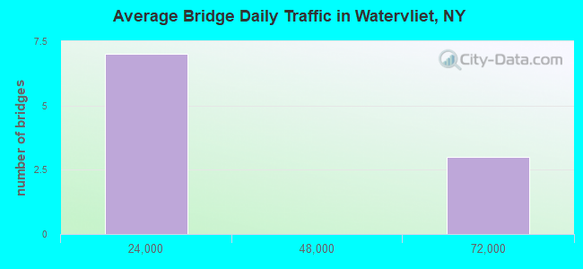
- 226,286Total average daily traffic
- 12,520Total average daily truck traffic
- National Bridge Inventory (NBI) Registered Bridges for Watervliet
- No street view available for this location
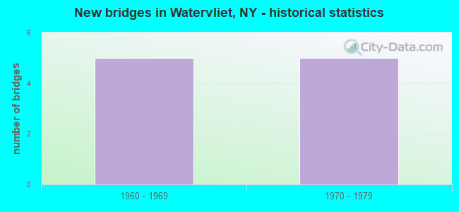
- New bridges - historical statistics
- 51960-1969
- 51970-1979
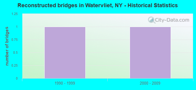
- Reconstructed bridges - Historical Statistics
- 11990-1999
- 12000-2009
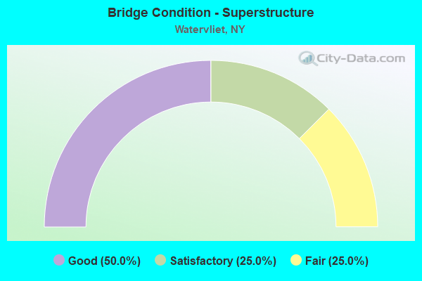
- Bridge Condition - Superstructure
- 50.0%Good
- 25.0%Satisfactory
- 25.0%Fair
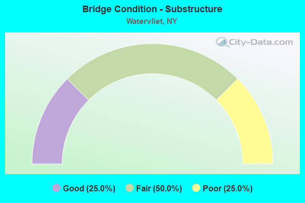
- Bridge Condition - Substructure
- 25.0%Good
- 50.0%Fair
- 25.0%Poor
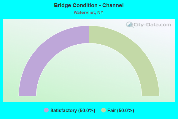
- Bridge Condition - Channel
- 50.0%Satisfactory
- 50.0%Fair
Find on map >> Show street view
Structure Number: 1004279, Location: CONGRESS ST BRIDGE (Lat: 42.729439, Lng: -73.699172), Route carried "on" structure: US 2, Year Built: 1969, Year Reconstructed: 2013, Status: Open, Structure Length: 43.40m (142.39ft), Average Daily Traffic: 8,952 (year 2008), Truck Traffic: 6%, Average Future Daily Traffic: 8,994 (year 2040), Design Load: HS 20, Features Intersected: 787I787I11013016 SB, RTE
Minimum Vertical Clearance: 30+ m (98+ ft), Kilometerpoint: 0.000, Lanes on structure: 4, Lanes under structure: 12, Base Highway Network: Yes, Owner: State Highway Agency, Approaching Roadway Width: 13.4m (44.0ft), Skew: 20 degrees, Navigation Control: Yes ( Vertical Clearance: 16.7m (54.8ft), Horizontal Clearance: 76.2m (250.0ft)), Material/Design: Steel, Design/Construction: Stringer/Multi-beam, Number Of Spans In Main Unit: 8, Length of Maximum Span: 94.4m (309.7ft), Curb or Sidewalk Widths: Left: 1.7m (5.6ft), Right: 1.7m (5.6ft), Curb-To-Curb Width: 18.3m (60.0ft), Out-to-Out Width: 23.3m (76.4ft)
Condition: Deck: Good, Superstructure: Satisfactory, Substructure: Fair, Channel: Satisfactory, Operating Rating: 93.3 metric tons, Method Used To Determine Operating Rating: Field evaluation and documented engineering judgment, Inventory Rating: 32.7 metric tons, Method Used To Determine Inventory Rating: Field evaluation and documented engineering judgment, Structural Evaluation: Somewhat better than minimum adequacy, Deck Geometry: Somewhat better than minimum adequacy, Underclear: High priority of corrective action, Waterway Adequacy: Somewhat better than minimum adequacy, Approach Roadway Alignment: Equal to present desirable criteria, Length Of Structure Improvement: 43.40m (142.39ft), Designated Inspection Frequency: Every 24 months, Underwater Inspection Frequency: Every 60 months, Inspection Date: November 2021, Underwater Inspection Date: September 2017, Bridge Improvement Cost: $20,456,000, Roadway Improvement Cost: $11,979,000, Total Project Cost: $32,435,000 ( Estimate for 2021), Deck Structure Type: Concrete Cast-file-Place, Wearing Surface/Protective System: Wearing Surface: Integral Concrete, Deck Protection: Other
Find on map >> Show street view
Structure Number: 103864, Location: 0.8 MI SW JCT 32 & 155 (Lat: 42.720400, Lng: -73.716150), Route carried "on" structure: State highway 155, Year Built: 1961, Year Reconstructed: 1995, Status: Open, Structure Length: 26.21m (85.99ft), Average Daily Traffic: 6,160 (year 2019), Truck Traffic: 4%, Average Future Daily Traffic: 7,483 (year 2040), Design Load: H 20, Features Intersected: LINCOLN AVE, D&H RAILROA
Minimum Vertical Clearance: 30+ m (98+ ft), Kilometerpoint: 25.985, Lanes on structure: 2, Lanes under structure: 4, Base Highway Network: Yes, Owner: State Highway Agency, Approaching Roadway Width: 9.1m (29.9ft), Material/Design: Steel, Design/Construction: Stringer/Multi-beam, Number Of Spans In Main Unit: 11, Length of Maximum Span: 33.5m (109.9ft), Curb-To-Curb Width: 9.8m (32.2ft), Out-to-Out Width: 10.7m (35.1ft)
Condition: Deck: Good, Superstructure: Fair, Substructure: Poor, Operating Rating: 66.2 metric tons, Method Used To Determine Operating Rating: Load Factor (LF), Inventory Rating: 33.6 metric tons, Method Used To Determine Inventory Rating: Load Factor (LF), Structural Evaluation: Meets minimum limits, Deck Geometry: Meets minimum limits, Underclear: High priority of corrective action, Approach Roadway Alignment: Equal to present desirable criteria, Length Of Structure Improvement: 26.21m (85.99ft), Designated Inspection Frequency: Every 24 months, Inspection Date: August 2020, Bridge Improvement Cost: $5,511,000, Roadway Improvement Cost: $3,227,000, Total Project Cost: $8,738,000 ( Estimate for 2021), Deck Structure Type: Concrete Cast-file-Place, Wearing Surface/Protective System: Wearing Surface: Integral Concrete
Find on map >> Show street view
Structure Number: 1092319, Location: 0.5 MI N JCT I787 & RT 7 (Lat: 42.735358, Lng: -73.698950), Route carried "on" structure: Interstate 787, Year Built: 1971, Status: Open, Structure Length: 2.99m (9.81ft), Average Daily Traffic: 60,998 (year 2019), Truck Traffic: 6%, Average Future Daily Traffic: 96,663 (year 2040), Design Load: HS 20, Features Intersected: ALBANY AVE-25THST
Minimum Vertical Clearance: 30+ m (98+ ft), Kilometerpoint: 14.143, Lanes on structure: 8, Lanes under structure: 2, Base Highway Network: Yes, Owner: State Highway Agency, Approaching Roadway Width: 53.9m (176.8ft), Skew: 20 degrees, Material/Design: Steel, Design/Construction: Stringer/Multi-beam, Number Of Spans In Main Unit: 1, Length of Maximum Span: 28.6m (93.8ft), Curb-To-Curb Width: 44.2m (145.0ft), Out-to-Out Width: 45.9m (150.6ft)
Condition: Deck: Good, Superstructure: Good, Substructure: Fair, Operating Rating: 91.4 metric tons, Method Used To Determine Operating Rating: Load and Resistance Factor Rating (LRFR) rating reported by rating factor(RF) method using HL-93 loadings, Inventory Rating: 70.6 metric tons, Method Used To Determine Inventory Rating: Load and Resistance Factor Rating (LRFR) rating reported by rating factor(RF) method using HL-93 loadings, Structural Evaluation: Somewhat better than minimum adequacy, Deck Geometry: Superior to present desirable criteria, Underclear: Equal to present minimum criteria, Approach Roadway Alignment: Equal to present desirable criteria, Length Of Structure Improvement: 2.98m (9.78ft), Designated Inspection Frequency: Every 24 months, Inspection Date: May 2020, Bridge Improvement Cost: $4,700,000, Roadway Improvement Cost: $2,752,000, Total Project Cost: $7,452,000 ( Estimate for 2021), Deck Structure Type: Concrete Cast-file-Place, Wearing Surface/Protective System: Wearing Surface: Monolithic Concrete
Find on map >> Show street view
Structure Number: 1092329, Location: I787 & 23RD ST - HUDSON A (Lat: 42.732611, Lng: -73.698339), Route carried "on" structure: Interstate 787, Year Built: 1971, Status: Open, Structure Length: 4.08m (13.39ft), Average Daily Traffic: 60,998 (year 2019), Truck Traffic: 6%, Average Future Daily Traffic: 96,663 (year 2040), Design Load: HS 20, Features Intersected: 23RD ST-HUDSON AV
Minimum Vertical Clearance: 30+ m (98+ ft), Kilometerpoint: 13.821, Lanes on structure: 6, Lanes under structure: 5, Base Highway Network: Yes, Owner: State Highway Agency, Approaching Roadway Width: 35.4m (116.1ft), Skew: 20 degrees, Material/Design: Steel, Design/Construction: Stringer/Multi-beam, Number Of Spans In Main Unit: 1, Length of Maximum Span: 39.6m (129.9ft), Curb-To-Curb Width: 35.4m (116.1ft), Out-to-Out Width: 37.2m (122.0ft)
Condition: Deck: Good, Superstructure: Good, Substructure: Good, Inventory Rating: 32.7 metric tons, Method Used To Determine Inventory Rating: Field evaluation and documented engineering judgment, Structural Evaluation: Better than present minimum criteria, Deck Geometry: Superior to present desirable criteria, Underclear: Somewhat better than minimum adequacy, Approach Roadway Alignment: Equal to present desirable criteria, Length Of Structure Improvement: 4.08m (13.39ft), Designated Inspection Frequency: Every 24 months, Inspection Date: July 2020, Bridge Improvement Cost: $4,679,000, Roadway Improvement Cost: $2,740,000, Total Project Cost: $7,420,000 ( Estimate for 2021), Deck Structure Type: Concrete Cast-file-Place, Wearing Surface/Protective System: Wearing Surface: Monolithic Concrete
Find on map >> Show street view
Structure Number: 109236, Location: 0.6 MI N JCT I787 & 378 (Lat: 42.709075, Lng: -73.705611), Route carried "on" structure: Interstate 787, Year Built: 1971, Status: Open, Structure Length: 0.70m (2.30ft), Average Daily Traffic: 60,998 (year 2019), Truck Traffic: 6%, Average Future Daily Traffic: 96,663 (year 2040), Features Intersected: LITTLE RIVER
Minimum Vertical Clearance: 30+ m (98+ ft), Kilometerpoint: 11.134, Lanes on structure: 6, Base Highway Network: Yes, Owner: State Highway Agency, Approaching Roadway Width: 31.1m (102.0ft), Skew: 22 degrees, Material/Design: Steel, Design/Construction: Culvert, Number Of Spans In Main Unit: 2, Length of Maximum Span: 2.7m (8.9ft)
Condition: Channel: Fair, Culverts: Poor, Operating Rating: 74.3 metric tons, Method Used To Determine Operating Rating: Field evaluation and documented engineering judgment, Inventory Rating: 29.4 metric tons, Method Used To Determine Inventory Rating: Field evaluation and documented engineering judgment, Structural Evaluation: Meets minimum limits, Waterway Adequacy: Meets minimum limits, Approach Roadway Alignment: Equal to present desirable criteria, Length Of Structure Improvement: 0.70m (2.30ft), Designated Inspection Frequency: Every 24 months, Inspection Date: September 2020, Bridge Improvement Cost: $384,000, Roadway Improvement Cost: $225,000, Total Project Cost: $609,000 ( Estimate for 2021)
Find on map >> Show street view
Structure Number: 1004279, Location: CONGRESS ST BRIDGE (Lat: 42.729439, Lng: -73.699172), Route carried "under" structure: Interstate 787, Year Built: 1969, Structure Length: 0. m, Average Daily Traffic: 11,500 (year 1978), Features Intersected: 787I787I11013016 SB, RTE, Facility Carried by Structure: RTE 2
Minimum Vertical Clearance: 7.21m (23.65ft), Kilometerpoint: 13.355, Lanes on structure: 4, Lanes under structure: 4, Material/Design: Steel, Design/Construction: Stringer/Multi-beam, Length of Maximum Span: 94.4m (309.7ft)
Find on map >> Show street view
Structure Number: 1004279, Location: CONGRESS ST BRIDGE (Lat: 42.729439, Lng: -73.699172), Route carried "under" structure: Interstate , Year Built: 1969, Structure Length: 0. m, Average Daily Traffic: 500 (year 2021), Features Intersected: 787I787I11013016 SB, RTE, Facility Carried by Structure: RTE 2
Minimum Vertical Clearance: 4.47m (14.67ft), Kilometerpoint: 13.355, Lanes on structure: 4, Lanes under structure: 2, Material/Design: Steel, Design/Construction: Stringer/Multi-beam, Length of Maximum Span: 94.4m (309.7ft)
Find on map >> Show street view
Structure Number: 103864, Location: 0.8 MI SW JCT 32 & 155 (Lat: 42.720400, Lng: -73.716150), Route carried "under" structure: Other road , Year Built: 1961, Structure Length: 0. m, Average Daily Traffic: 500 (year 2016), Truck Traffic: 5%, Features Intersected: LINCOLN AVE, D&H RAILROA, Facility Carried by Structure: RTE 155
Minimum Vertical Clearance: 7.52m (24.67ft), Kilometerpoint: 0.000, Lanes on structure: 2, Lanes under structure: 2, Material/Design: Steel, Design/Construction: Stringer/Multi-beam, Length of Maximum Span: 33.5m (109.9ft)
Find on map >> Show street view
Structure Number: 1092319, Location: 0.5 MI N JCT I787 & RT 7 (Lat: 42.735358, Lng: -73.698950), Route carried "under" structure: City street , Year Built: 1971, Structure Length: 0. m, Average Daily Traffic: 3,642 (year 2019), Truck Traffic: 7%, Features Intersected: ALBANY AVE-25THST, Facility Carried by Structure: RTE I787
Minimum Vertical Clearance: 5.56m (18.24ft), Kilometerpoint: 0.000, Lanes on structure: 8, Lanes under structure: 2, Material/Design: Steel, Design/Construction: Stringer/Multi-beam, Length of Maximum Span: 28.6m (93.8ft)
Find on map >> Show street view
Structure Number: 1092329, Location: I787 & 23RD ST - HUDSON A (Lat: 42.732611, Lng: -73.698339), Route carried "under" structure: City street , Year Built: 1971, Structure Length: 0. m, Average Daily Traffic: 12,038 (year 2017), Truck Traffic: 4%, Features Intersected: 23RD ST-HUDSON AV, Facility Carried by Structure: RTE I787
Minimum Vertical Clearance: 5.54m (18.18ft), Kilometerpoint: 0.000, Lanes on structure: 6, Lanes under structure: 5, Material/Design: Steel, Design/Construction: Stringer/Multi-beam, Length of Maximum Span: 39.6m (129.9ft)