Bridge Statistics for Watkins, Colorado (CO)
Condition, Traffic, Stress, Structural Evaluation, Project Costs
- National Bridge Inventory (NBI) Statistics
- 10Number of bridges
- 138ft / 42.2mTotal length
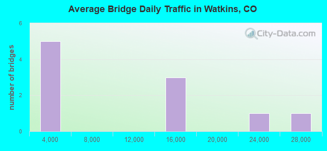
- 95,894Total average daily traffic
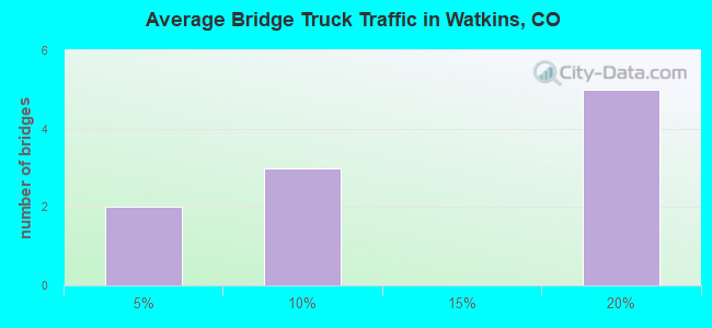
- 16,786Total average daily truck traffic
- National Bridge Inventory (NBI) Registered Bridges for Watkins
- No street view available for this location
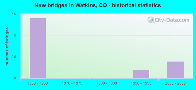
- New bridges - historical statistics
- 71960-1969
- 11990-1999
- 22000-2009
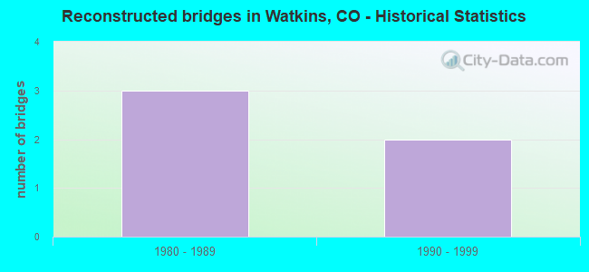
- Reconstructed bridges - Historical Statistics
- 31980-1989
- 21990-1999
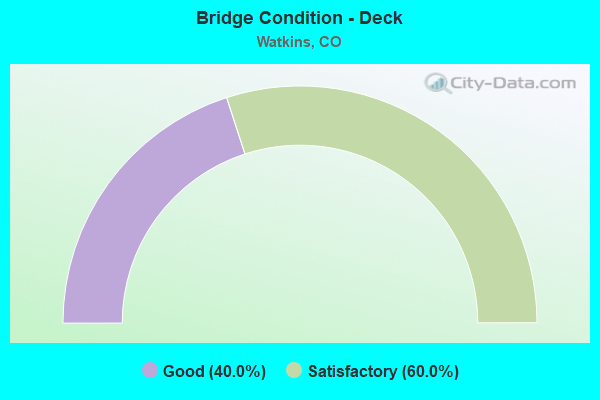
- Bridge Condition - Deck
- 40.0%Good
- 60.0%Satisfactory
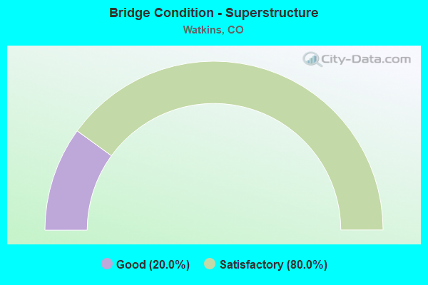
- Bridge Condition - Superstructure
- 20.0%Good
- 80.0%Satisfactory
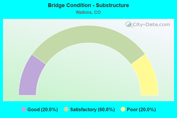
- Bridge Condition - Substructure
- 20.0%Good
- 60.0%Satisfactory
- 20.0%Poor
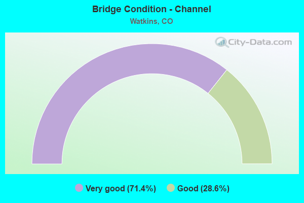
- Bridge Condition - Channel
- 71.4%Very good
- 28.6%Good
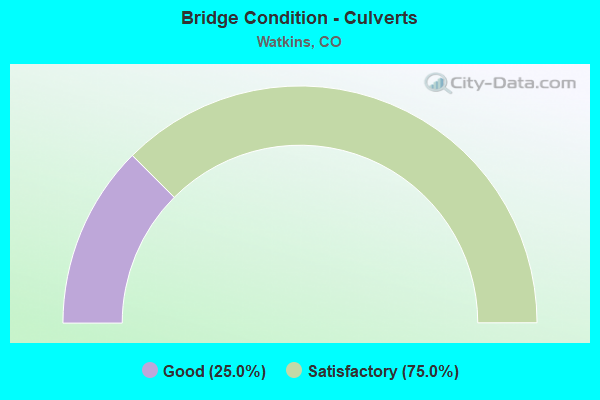
- Bridge Condition - Culverts
- 25.0%Good
- 75.0%Satisfactory
Find on map >> Show street view
Structure Number: ARA 05-25.3, Location: .1 MI E OF IMBODEN RD (Lat: 39.726244, Lng: -104.580903), Route carried "on" structure: County highway , Year Built: 2002, Status: Open, Structure Length: 2.13m (6.99ft), Average Daily Traffic: 265 (year 2021), Truck Traffic: 2%, Average Future Daily Traffic: 323 (year 2041), Design Load: HS 20+Mod, Features Intersected: BOXELDER CREEK TRIBUTARY, Facility Carried by Structure: 7TH AVENUE
Minimum Vertical Clearance: 30+ m (98+ ft), Kilometerpoint: 0.214, Lanes on structure: 2, Owner: County Highway Agency, Approaching Roadway Width: 6.8m (22.3ft), Skew: 2 degrees, Material/Design: Concrete, Design/Construction: Culvert, Number Of Spans In Main Unit: 5, Length of Maximum Span: 4.0m (13.1ft), Out-to-Out Width: 13.4m (44.0ft)
Condition: Channel: Very good, Culverts: Satisfactory, Operating Rating: 55.2 metric tons, Method Used To Determine Operating Rating: Load Factor (LF), Inventory Rating: 33.1 metric tons, Method Used To Determine Inventory Rating: Load Factor (LF), Structural Evaluation: Equal to present minimum criteria, Waterway Adequacy: Equal to present desirable criteria, Approach Roadway Alignment: Equal to present desirable criteria, Designated Inspection Frequency: Every 24 months, Inspection Date: November 2021
Find on map >> Show street view
Structure Number: ARA 101-11.2, Location: .3 MI N OF 6TH AVE (Lat: 39.728289, Lng: -104.581444), Route carried "on" structure: County highway , Year Built: 2002, Status: Open, Structure Length: 1.93m (6.33ft), Average Daily Traffic: 183 (year 2021), Truck Traffic: 1%, Average Future Daily Traffic: 223 (year 2041), Design Load: HS 20+Mod, Features Intersected: BOX ELDER CREEK TRIB, Facility Carried by Structure: IMBODEN ROAD
Minimum Vertical Clearance: 30+ m (98+ ft), Kilometerpoint: 2.910, Lanes on structure: 2, Owner: County Highway Agency, Approaching Roadway Width: 7.5m (24.6ft), Material/Design: Concrete, Design/Construction: Culvert, Number Of Spans In Main Unit: 5, Length of Maximum Span: 3.7m (12.1ft), Out-to-Out Width: 13.4m (44.0ft)
Condition: Channel: Very good, Culverts: Satisfactory, Operating Rating: 47.7 metric tons, Method Used To Determine Operating Rating: Load Factor (LF), Inventory Rating: 28.6 metric tons, Method Used To Determine Inventory Rating: Load Factor (LF), Structural Evaluation: Equal to present minimum criteria, Waterway Adequacy: Equal to present desirable criteria, Approach Roadway Alignment: Equal to present desirable criteria, Designated Inspection Frequency: Every 24 months, Inspection Date: November 2021
Find on map >> Show street view
Structure Number: ARA 97-10.9, Location: 0.9 MI S OF I-70 (Lat: 39.725278, Lng: -104.603228), Route carried "on" structure: County highway , Year Built: 1968, Status: Open, Structure Length: 1.62m (5.31ft), Average Daily Traffic: 3,646 (year 2021), Truck Traffic: 9%, Average Future Daily Traffic: 4,449 (year 2041), Design Load: HS 20, Features Intersected: LOCAL DRAINAGE, Facility Carried by Structure: WATKINS ROAD
Minimum Vertical Clearance: 30+ m (98+ ft), Kilometerpoint: 3.073, Lanes on structure: 2, Owner: County Highway Agency, Approaching Roadway Width: 7.3m (24.0ft), Material/Design: Prestressed concrete, Design/Construction: Tee Beam, Number Of Spans In Main Unit: 1, Length of Maximum Span: 15.2m (49.9ft), Curb-To-Curb Width: 9.8m (32.2ft), Out-to-Out Width: 10.5m (34.4ft)
Condition: Deck: Satisfactory, Superstructure: Satisfactory, Substructure: Satisfactory, Channel: Very good, Operating Rating: 38.0 metric tons, Method Used To Determine Operating Rating: Load Factor (LF), Inventory Rating: 22.8 metric tons, Method Used To Determine Inventory Rating: Load Factor (LF), Structural Evaluation: Equal to present minimum criteria, Deck Geometry: Meets minimum limits, Waterway Adequacy: Equal to present desirable criteria, Approach Roadway Alignment: Equal to present desirable criteria, Designated Inspection Frequency: Every 24 months, Inspection Date: November 2021, Deck Structure Type: Concrete Cast-file-Place, Wearing Surface/Protective System: Wearing Surface: Bituminous
Find on map >> Show street view
Structure Number: F-18-AV, Location: 6.4 MI E OF JCT US 36 (Lat: 39.738603, Lng: -104.527147), Route carried "on" structure: Interstate 70A, Year Built: 1960, Year Reconstructed: 1986, Status: Open, Structure Length: 2.87m (9.42ft), Average Daily Traffic: 13,000 (year 2020), Truck Traffic: 18%, Average Future Daily Traffic: 17,420 (year 2040), Design Load: HS 20, Features Intersected: COUNTY ROADS 28N,113, Facility Carried by Structure: I 70 ML EBND
Minimum Vertical Clearance: 30+ m (98+ ft), Kilometerpoint: 482.840, Lanes on structure: 2, Lanes under structure: 2, Base Highway Network: Yes, Owner: State Highway Agency, Approaching Roadway Width: 11.6m (38.1ft), Skew: 10 degrees, Material/Design: Concrete, Design/Construction: Tee Beam, Number Of Spans In Main Unit: 3, Length of Maximum Span: 9.1m (29.9ft), Curb-To-Curb Width: 11.6m (38.1ft), Out-to-Out Width: 12.8m (42.0ft)
Condition: Deck: Satisfactory, Superstructure: Satisfactory, Substructure: Poor, Operating Rating: 74.1 metric tons, Method Used To Determine Operating Rating: Load Factor (LF), Inventory Rating: 44.4 metric tons, Method Used To Determine Inventory Rating: Load Factor (LF), Structural Evaluation: Meets minimum limits, Deck Geometry: Equal to present minimum criteria, Underclear: High priority of corrective action, Approach Roadway Alignment: Equal to present desirable criteria, Designated Inspection Frequency: Every 24 months, Inspection Date: May 2021, Deck Structure Type: Concrete Cast-file-Place, Wearing Surface/Protective System: Wearing Surface: Integral Concrete, Deck Protection: Cathodic Protection
Find on map >> Show street view
Structure Number: F-18-BB, Location: 1.7 MI E OF JCT I 70 (Lat: 39.742286, Lng: -104.615389), Route carried "on" structure: US 36C, Year Built: 1990, Status: Open, Structure Length: 1.62m (5.31ft), Average Daily Traffic: 1,500 (year 2020), Truck Traffic: 7%, Average Future Daily Traffic: 1,905 (year 2040), Design Load: HS 20, Features Intersected: DRAW, Facility Carried by Structure: US 36 ML
Minimum Vertical Clearance: 30+ m (98+ ft), Kilometerpoint: 4.263, Lanes on structure: 2, Owner: State Highway Agency, Approaching Roadway Width: 7.6m (24.9ft), Skew: 3 degrees, Material/Design: Concrete, Design/Construction: Culvert, Number Of Spans In Main Unit: 3, Length of Maximum Span: 5.9m (19.4ft), Out-to-Out Width: 26.5m (86.9ft)
Condition: Channel: Very good, Culverts: Good, Operating Rating: 36.3 metric tons, Method Used To Determine Operating Rating: Field evaluation and documented engineering judgment, Inventory Rating: 32.7 metric tons, Method Used To Determine Inventory Rating: Field evaluation and documented engineering judgment, Structural Evaluation: Better than present minimum criteria, Waterway Adequacy: Equal to present desirable criteria, Approach Roadway Alignment: Equal to present desirable criteria, Designated Inspection Frequency: Every 48 months, Inspection Date: September 2019
Find on map >> Show street view
Structure Number: F-18-E, Location: 1.8 MI E OF JCT US 36 (Lat: 39.739928, Lng: -104.613828), Route carried "on" structure: Interstate 70A, Year Built: 1960, Year Reconstructed: 1985, Status: Open, Structure Length: 2.87m (9.42ft), Average Daily Traffic: 13,000 (year 2020), Truck Traffic: 19%, Average Future Daily Traffic: 17,030 (year 2040), Design Load: HS 20, Features Intersected: DRAW, Facility Carried by Structure: I 70 ML EBND
Minimum Vertical Clearance: 30+ m (98+ ft), Kilometerpoint: 475.408, Lanes on structure: 2, Base Highway Network: Yes, Owner: State Highway Agency, Approaching Roadway Width: 11.6m (38.1ft), Skew: 10 degrees, Material/Design: Concrete, Design/Construction: Tee Beam, Number Of Spans In Main Unit: 3, Length of Maximum Span: 9.0m (29.5ft), Curb-To-Curb Width: 11.6m (38.1ft), Out-to-Out Width: 12.8m (42.0ft)
Condition: Deck: Good, Superstructure: Satisfactory, Substructure: Satisfactory, Channel: Good, Operating Rating: 47.3 metric tons, Method Used To Determine Operating Rating: Load Factor (LF), Inventory Rating: 28.3 metric tons, Method Used To Determine Inventory Rating: Load Factor (LF), Structural Evaluation: Equal to present minimum criteria, Deck Geometry: Equal to present minimum criteria, Waterway Adequacy: Superior to present desirable criteria, Approach Roadway Alignment: Equal to present desirable criteria, Designated Inspection Frequency: Every 24 months, Inspection Date: June 2021, Deck Structure Type: Concrete Cast-file-Place, Wearing Surface/Protective System: Wearing Surface: Integral Concrete, Deck Protection: Cathodic Protection
Find on map >> Show street view
Structure Number: F-18-M, Location: 1 MI E OF WATKINS INTERCH (Lat: 39.739594, Lng: -104.583036), Route carried "on" structure: Interstate 70A, Year Built: 1960, Year Reconstructed: 1986, Status: Open, Structure Length: 21.41m (70.24ft), Average Daily Traffic: 13,000 (year 2020), Truck Traffic: 18%, Average Future Daily Traffic: 17,420 (year 2040), Design Load: HS 20, Features Intersected: BOX ELDER CREEK, Facility Carried by Structure: I 70 ML EBND
Minimum Vertical Clearance: 30+ m (98+ ft), Kilometerpoint: 478.049, Lanes on structure: 2, Base Highway Network: Yes, Owner: State Highway Agency, Approaching Roadway Width: 11.6m (38.1ft), Skew: 13 degrees, Material/Design: Prestressed concrete continuous, Design/Construction: Stringer/Multi-beam, Number Of Spans In Main Unit: 12, Length of Maximum Span: 17.7m (58.1ft), Curb-To-Curb Width: 11.6m (38.1ft), Out-to-Out Width: 12.3m (40.4ft)
Condition: Deck: Satisfactory, Superstructure: Satisfactory, Substructure: Satisfactory, Channel: Very good, Operating Rating: 37.4 metric tons, Method Used To Determine Operating Rating: Load Factor (LF), Inventory Rating: 22.3 metric tons, Method Used To Determine Inventory Rating: Load Factor (LF), Structural Evaluation: Somewhat better than minimum adequacy, Deck Geometry: Equal to present minimum criteria, Waterway Adequacy: Equal to present desirable criteria, Approach Roadway Alignment: Equal to present desirable criteria, Designated Inspection Frequency: Every 24 months, Inspection Date: April 2021, Deck Structure Type: Concrete Cast-file-Place, Wearing Surface/Protective System: Wearing Surface: Integral Concrete, Deck Protection: Epoxy Coated Reinforcing
Find on map >> Show street view
Structure Number: F-18-R, Location: WATKINS INTERCHANGE (Lat: 39.739706, Lng: -104.603072), Route carried "on" structure: Spur State highway 70L, Year Built: 1960, Year Reconstructed: 1997, Status: Open, Structure Length: 6.95m (22.80ft), Average Daily Traffic: 3,300 (year 2020), Truck Traffic: 9%, Average Future Daily Traffic: 3,663 (year 2040), Design Load: HS 20+Mod, Features Intersected: I 70 ML, Facility Carried by Structure: I 70 BUS SPUR
Minimum Vertical Clearance: 30+ m (98+ ft), Kilometerpoint: 0.135, Lanes on structure: 2, Lanes under structure: 4, Owner: State Highway Agency, Approaching Roadway Width: 8.8m (28.9ft), Material/Design: Concrete continuous, Design/Construction: Tee Beam, Number Of Spans In Main Unit: 4, Length of Maximum Span: 19.8m (65.0ft), Curb-To-Curb Width: 8.5m (27.9ft), Out-to-Out Width: 9.8m (32.2ft)
Condition: Deck: Good, Superstructure: Good, Substructure: Good, Operating Rating: 65.1 metric tons, Method Used To Determine Operating Rating: Load Factor (LF), Inventory Rating: 39.0 metric tons, Method Used To Determine Inventory Rating: Load Factor (LF), Structural Evaluation: Better than present minimum criteria, Deck Geometry: Meets minimum limits, Underclear: Meets minimum limits, Approach Roadway Alignment: Better than present minimum criteria, Designated Inspection Frequency: Every 24 months, Inspection Date: May 2021, Deck Structure Type: Concrete Cast-file-Place, Wearing Surface/Protective System: Wearing Surface: Integral Concrete
Find on map >> Show street view
Structure Number: F-18-W, Location: 0.75 MI W OF WATKINS INTC (Lat: 39.739947, Lng: -104.616731), Route carried "on" structure: Interstate 70A, Year Built: 1960, Year Reconstructed: 1998, Status: Open, Structure Length: 0.76m (2.49ft), Average Daily Traffic: 26,000 (year 2020), Truck Traffic: 19%, Average Future Daily Traffic: 34,060 (year 2040), Design Load: H 20, Features Intersected: DRAW, Facility Carried by Structure: I 70 ML
Minimum Vertical Clearance: 30+ m (98+ ft), Kilometerpoint: 475.160, Lanes on structure: 4, Base Highway Network: Yes, Owner: State Highway Agency, Approaching Roadway Width: 23.2m (76.1ft), Skew: 10 degrees, Material/Design: Concrete, Design/Construction: Culvert, Number Of Spans In Main Unit: 2, Length of Maximum Span: 3.7m (12.1ft), Out-to-Out Width: 55.5m (182.1ft)
Condition: Channel: Good, Culverts: Satisfactory, Operating Rating: 36.3 metric tons, Method Used To Determine Operating Rating: Load Factor (LF), Inventory Rating: 32.7 metric tons, Method Used To Determine Inventory Rating: Load Factor (LF), Structural Evaluation: Equal to present minimum criteria, Waterway Adequacy: Equal to present minimum criteria, Approach Roadway Alignment: Equal to present desirable criteria, Designated Inspection Frequency: Every 24 months, Inspection Date: August 2021
Find on map >> Show street view
Structure Number: F-18-R, Location: WATKINS INTERCHANGE (Lat: 39.739706, Lng: -104.603072), Route carried "under" structure: Interstate 70A, Year Built: 1960, Structure Length: 0. m, Average Daily Traffic: 22,000 (year 2011), Truck Traffic: 18%, Features Intersected: I 70 ML, Facility Carried by Structure: I 70 BUS SPUR
Minimum Vertical Clearance: 5.54m (18.18ft), Kilometerpoint: 475.067, Lanes on structure: 2, Lanes under structure: 4, Material/Design: Concrete continuous, Design/Construction: Tee Beam, Length of Maximum Span: 19.8m (65.0ft)