Bridge Statistics for West Goshen, Pennsylvania (PA)
Condition, Traffic, Stress, Structural Evaluation, Project Costs
- National Bridge Inventory (NBI) Statistics
- 10Number of bridges
- 39ft / 12.0mTotal length
- $386,000Total costs
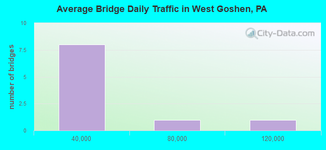
- 343,095Total average daily traffic
- 16,342Total average daily truck traffic
- National Bridge Inventory (NBI) Registered Bridges for West Goshen
- No street view available for this location
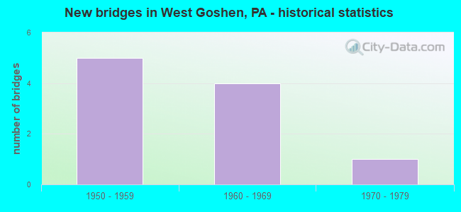
- New bridges - historical statistics
- 61950-1959
- 41960-1969
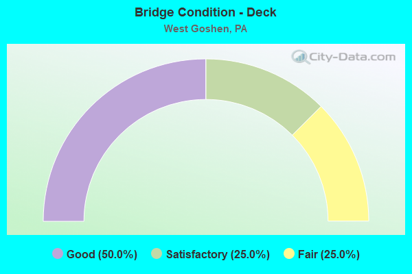
- Bridge Condition - Deck
- 25.0%Good
- 50.0%Satisfactory
- 25.0%Fair
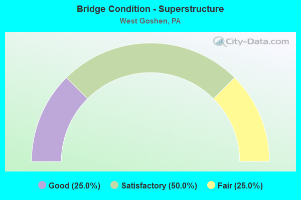
- Bridge Condition - Superstructure
- 75.0%Satisfactory
- 25.0%Fair
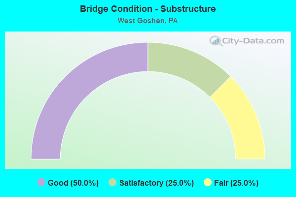
- Bridge Condition - Substructure
- 25.0%Good
- 50.0%Satisfactory
- 25.0%Fair
Find on map >> Show street view
Structure Number: 9923, Location: NEAR WEST CHESTER 32C09 (Lat: 39.966400, Lng: -75.590844), Route carried "on" structure: State highway 3, Year Built: 1960, Status: Open, Structure Length: 2.96m (9.71ft), Average Daily Traffic: 7,929 (year 2022), Truck Traffic: 4%, Average Future Daily Traffic: 21,565 (year 2032), Design Load: HS 20, Features Intersected: PAOLI PIKE, Facility Carried by Structure: WEST CHESTER PIKE
Minimum Vertical Clearance: 30+ m (98+ ft), Kilometerpoint: 1.642, Lanes on structure: 2, Lanes under structure: 2, Base Highway Network: Yes, Owner: State Highway Agency, Approaching Roadway Width: 9.8m (32.2ft), Material/Design: Prestressed concrete, Design/Construction: Box Beam or Girders - Single/Spread, Number Of Spans In Main Unit: 3, Length of Maximum Span: 11.9m (39.0ft), Curb or Sidewalk Widths: Left: 0.2m (0.7ft), Right: 0.2m (0.7ft), Curb-To-Curb Width: 8.5m (27.9ft), Out-to-Out Width: 10.2m (33.5ft)
Condition: Deck: Satisfactory, Superstructure: Satisfactory, Substructure: Fair, Operating Rating: 64.4 metric tons, Method Used To Determine Operating Rating: Load Factor (LF), Inventory Rating: 29.0 metric tons, Method Used To Determine Inventory Rating: Load Factor (LF), Structural Evaluation: Somewhat better than minimum adequacy, Deck Geometry: High priority of corrective action, Underclear: Meets minimum limits, Approach Roadway Alignment: Better than present minimum criteria, Length Of Structure Improvement: 3.70m (12.14ft), Designated Inspection Frequency: Every 24 months, Inspection Date: July 2020, Deck Structure Type: Concrete Cast-file-Place, Wearing Surface/Protective System: Wearing Surface: Latex Concrete
Find on map >> Show street view
Structure Number: 10094, Location: NEAR WEST CHESTER 32E11 (Lat: 39.956133, Lng: -75.580492), Route carried "on" structure: US 202, Year Built: 1967, Status: Open, Structure Length: 2.26m (7.41ft), Average Daily Traffic: 59,892 (year 2022), Truck Traffic: 4%, Average Future Daily Traffic: 66,096 (year 2032), Design Load: HS 20, Features Intersected: WESTTOWN ROAD, Facility Carried by Structure: WEST CHESTER BYPAS
Minimum Vertical Clearance: 30+ m (98+ ft), Kilometerpoint: 6.988, Lanes on structure: 2, Lanes under structure: 2, Base Highway Network: Yes, Owner: State Highway Agency, Approaching Roadway Width: 21.0m (68.9ft), Skew: 30 degrees, Material/Design: Prestressed concrete, Design/Construction: Box Beam or Girders - Single/Spread, Number Of Spans In Main Unit: 1, Length of Maximum Span: 21.9m (71.9ft), Curb or Sidewalk Widths: Left: 0.2m (0.7ft), Right: 0.2m (0.7ft), Curb-To-Curb Width: 20.9m (68.6ft), Out-to-Out Width: 21.9m (71.9ft)
Condition: Deck: Good, Superstructure: Satisfactory, Substructure: Good, Operating Rating: 72.6 metric tons, Method Used To Determine Operating Rating: Load Factor (LF), Inventory Rating: 30.8 metric tons, Method Used To Determine Inventory Rating: Load Factor (LF), Structural Evaluation: Equal to present minimum criteria, Deck Geometry: Superior to present desirable criteria, Underclear: Somewhat better than minimum adequacy, Approach Roadway Alignment: Equal to present desirable criteria, Length Of Structure Improvement: 3.00m (9.84ft), Designated Inspection Frequency: Every 24 months, Inspection Date: July 2020, Deck Structure Type: Concrete Cast-file-Place, Wearing Surface/Protective System: Wearing Surface: Bituminous
Find on map >> Show street view
Structure Number: 10096, Location: EAST WEST CHESTER 32E09 (Lat: 39.967414, Lng: -75.581650), Route carried "on" structure: US 202, Year Built: 1954, Status: Open, Structure Length: 3.78m (12.40ft), Average Daily Traffic: 112,872 (year 2022), Truck Traffic: 5%, Average Future Daily Traffic: 75,910 (year 2032), Design Load: HS 20, Features Intersected: WEST CHESTER PIKE, Facility Carried by Structure: WEST CHESTER BYPAS
Minimum Vertical Clearance: 30+ m (98+ ft), Kilometerpoint: 8.270, Lanes on structure: 3, Lanes under structure: 6, Base Highway Network: Yes, Owner: State Highway Agency, Approaching Roadway Width: 26.8m (87.9ft), Skew: 30 degrees, Material/Design: Steel, Design/Construction: Stringer/Multi-beam, Number Of Spans In Main Unit: 1, Length of Maximum Span: 37.5m (123.0ft), Curb-To-Curb Width: 23.3m (76.4ft), Out-to-Out Width: 25.6m (84.0ft)
Condition: Deck: Satisfactory, Superstructure: Satisfactory, Substructure: Satisfactory, Operating Rating: 79.8 metric tons, Method Used To Determine Operating Rating: Load Factor (LF), Inventory Rating: 48.1 metric tons, Method Used To Determine Inventory Rating: Load Factor (LF), Structural Evaluation: Equal to present minimum criteria, Deck Geometry: Superior to present desirable criteria, Underclear: Equal to present minimum criteria, Approach Roadway Alignment: Equal to present desirable criteria, Length Of Structure Improvement: 4.70m (15.42ft), Designated Inspection Frequency: Every 24 months, Inspection Date: August 2020, Bridge Improvement Cost: $29,000, Roadway Improvement Cost: $84,000, Total Project Cost: $386,000, Deck Structure Type: Concrete Cast-file-Place, Wearing Surface/Protective System: Wearing Surface: Bituminous
Find on map >> Show street view
Structure Number: 10099, Location: EAST WEST CHESTER 32D08 (Lat: 39.971033, Lng: -75.582922), Route carried "on" structure: US 202, Year Built: 1954, Year Reconstructed: 1967, Status: Open, Structure Length: 3.02m (9.91ft), Average Daily Traffic: 112,872 (year 2022), Truck Traffic: 5%, Average Future Daily Traffic: 75,910 (year 2032), Design Load: HS 20, Features Intersected: PAOLI PIKE (OLD US 202), Facility Carried by Structure: WEST CHESTER BYPAS
Minimum Vertical Clearance: 30+ m (98+ ft), Kilometerpoint: 8.692, Lanes on structure: 3, Lanes under structure: 5, Base Highway Network: Yes, Owner: State Highway Agency, Approaching Roadway Width: 27.4m (89.9ft), Skew: 32 degrees, Material/Design: Steel, Design/Construction: Stringer/Multi-beam, Number Of Spans In Main Unit: 1, Length of Maximum Span: 28.7m (94.2ft), Curb-To-Curb Width: 23.3m (76.4ft), Out-to-Out Width: 25.6m (84.0ft)
Condition: Deck: Fair, Superstructure: Fair, Substructure: Satisfactory, Operating Rating: 53.5 metric tons, Method Used To Determine Operating Rating: Load Factor (LF), Inventory Rating: 31.8 metric tons, Method Used To Determine Inventory Rating: Load Factor (LF), Structural Evaluation: Somewhat better than minimum adequacy, Deck Geometry: Superior to present desirable criteria, Underclear: Equal to present minimum criteria, Approach Roadway Alignment: Equal to present desirable criteria, Length Of Structure Improvement: 3.80m (12.47ft), Designated Inspection Frequency: Every 24 months, Inspection Date: May 2020, Deck Structure Type: Concrete Cast-file-Place, Wearing Surface/Protective System: Wearing Surface: Bituminous
Find on map >> Show street view
Structure Number: 9923, Location: NEAR WEST CHESTER 32C09 (Lat: 39.966400, Lng: -75.590844), Route carried "under" structure: State highway , Year Built: 1960, Structure Length: 0. m, Average Daily Traffic: 4,843 (year 2020), Truck Traffic: 5%, Features Intersected: PAOLI PIKE, Facility Carried by Structure: WEST CHESTER PIKE
Minimum Vertical Clearance: 4.47m (14.67ft), Kilometerpoint: 0.000, Lanes on structure: 2, Lanes under structure: 2, Material/Design: Prestressed concrete, Design/Construction: Box Beam or Girders - Single/Spread, Length of Maximum Span: 11.9m (39.0ft)
Find on map >> Show street view
Structure Number: 10094, Location: NEAR WEST CHESTER 32E11 (Lat: 39.956133, Lng: -75.580492), Route carried "under" structure: State highway , Year Built: 1967, Structure Length: 0. m, Average Daily Traffic: 8,174 (year 2022), Truck Traffic: 5%, Features Intersected: WESTTOWN ROAD, Facility Carried by Structure: WEST CHESTER BYPAS
Minimum Vertical Clearance: 4.50m (14.76ft), Kilometerpoint: 6.856, Lanes on structure: 2, Lanes under structure: 2, Material/Design: Prestressed concrete, Design/Construction: Box Beam or Girders - Single/Spread, Length of Maximum Span: 21.9m (71.9ft)
Find on map >> Show street view
Structure Number: 10096, Location: EAST WEST CHESTER 32E09 (Lat: 39.967414, Lng: -75.581650), Route carried "under" structure: State highway 3, Year Built: 1954, Structure Length: 0. m, Average Daily Traffic: 11,402 (year 2022), Truck Traffic: 7%, Features Intersected: WEST CHESTER PIKE, Facility Carried by Structure: WEST CHESTER BYPAS
Minimum Vertical Clearance: 4.47m (14.67ft), Kilometerpoint: 2.522, Lanes on structure: 3, Lanes under structure: 3, Material/Design: Steel, Design/Construction: Stringer/Multi-beam, Length of Maximum Span: 37.5m (123.0ft)
Find on map >> Show street view
Structure Number: 10096, Location: EAST WEST CHESTER 32E09 (Lat: 39.967414, Lng: -75.581650), Route carried "under" structure: State highway 3, Year Built: 1954, Structure Length: 0. m, Average Daily Traffic: 10,695 (year 2022), Truck Traffic: 3%, Features Intersected: WEST CHESTER PIKE, Facility Carried by Structure: WEST CHESTER BYPAS
Minimum Vertical Clearance: 4.78m (15.68ft), Kilometerpoint: 2.414, Lanes on structure: 3, Lanes under structure: 3, Material/Design: Steel, Design/Construction: Stringer/Multi-beam, Length of Maximum Span: 37.5m (123.0ft)
Find on map >> Show street view
Structure Number: 10099, Location: EAST WEST CHESTER 32D08 (Lat: 39.971033, Lng: -75.582922), Route carried "under" structure: State highway , Year Built: 1954, Structure Length: 0. m, Average Daily Traffic: 7,208 (year 2022), Truck Traffic: 4%, Features Intersected: PAOLI PIKE (OLD US 202), Facility Carried by Structure: WEST CHESTER BYPAS
Minimum Vertical Clearance: 4.44m (14.57ft), Kilometerpoint: 0.235, Lanes on structure: 3, Lanes under structure: 2, Material/Design: Steel, Design/Construction: Stringer/Multi-beam, Length of Maximum Span: 28.7m (94.2ft)
Find on map >> Show street view
Structure Number: 10099, Location: EAST WEST CHESTER 32D08 (Lat: 39.971033, Lng: -75.582922), Route carried "under" structure: State highway , Year Built: 1954, Structure Length: 0. m, Average Daily Traffic: 7,208 (year 2022), Truck Traffic: 4%, Features Intersected: PAOLI PIKE (OLD US 202), Facility Carried by Structure: WEST CHESTER BYPAS
Minimum Vertical Clearance: 4.47m (14.67ft), Kilometerpoint: 0.290, Lanes on structure: 3, Lanes under structure: 3, Material/Design: Steel, Design/Construction: Stringer/Multi-beam, Length of Maximum Span: 28.7m (94.2ft)