Bridge Statistics for West Mineral, Kansas (KS)
Condition, Traffic, Stress, Structural Evaluation, Project Costs
- National Bridge Inventory (NBI) Statistics
- 14Number of bridges
- 92ft / 28.3mTotal length
- $1,708,000Total costs
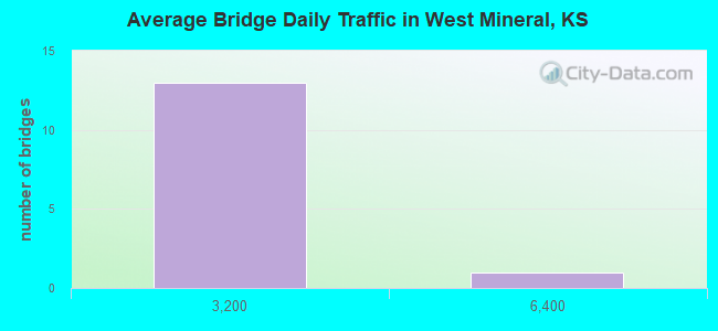
- 6,694Total average daily traffic
- 1,184Total average daily truck traffic
- 9,993Total future (year 2041) average daily traffic
- National Bridge Inventory (NBI) Registered Bridges for West Mineral
- No street view available for this location
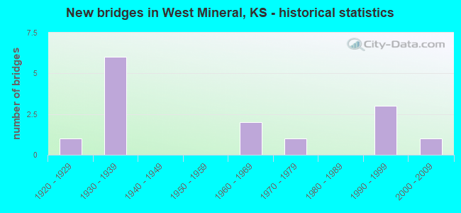
- New bridges - historical statistics
- 11920-1929
- 61930-1939
- 21960-1969
- 11970-1979
- 31990-1999
- 12000-2009
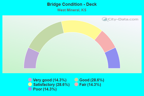
- Bridge Condition - Deck
- 14.3%Very good
- 28.6%Good
- 28.6%Satisfactory
- 14.3%Fair
- 14.3%Poor
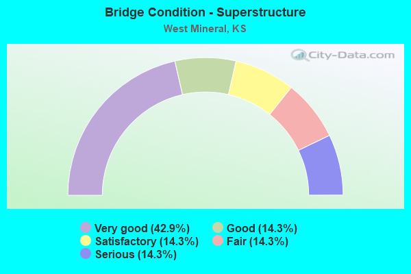
- Bridge Condition - Superstructure
- 42.9%Very good
- 14.3%Good
- 14.3%Satisfactory
- 14.3%Fair
- 14.3%Serious
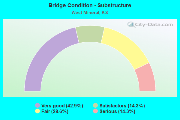
- Bridge Condition - Substructure
- 42.9%Very good
- 14.3%Satisfactory
- 28.6%Fair
- 14.3%Serious
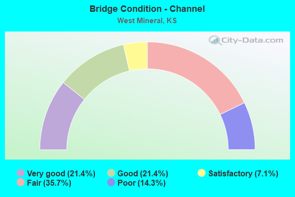
- Bridge Condition - Channel
- 21.4%Very good
- 21.4%Good
- 7.1%Satisfactory
- 35.7%Fair
- 14.3%Poor
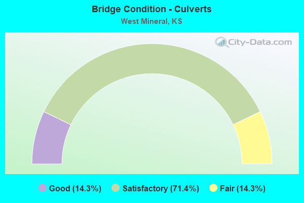
- Bridge Condition - Culverts
- 14.3%Good
- 71.4%Satisfactory
- 14.3%Fair
Find on map >> Show street view
Structure Number: 11029, Location: 4.0N 0.5E OF HALLOWELL (Lat: 37.236667, Lng: -94.983333), Route carried "on" structure: County highway 1166, Year Built: 1935, Status: Open, Structure Length: 0.97m (3.18ft), Average Daily Traffic: 69 (year 2007), Average Future Daily Traffic: 72 (year 2041), Features Intersected: DEER CREEK
Minimum Vertical Clearance: 30.47m (99.97ft), Kilometerpoint: 0.966, Lanes on structure: 2, Owner: County Highway Agency, Approaching Roadway Width: 7.3m (24.0ft), Material/Design: Concrete, Design/Construction: Culvert, Number Of Spans In Main Unit: 3, Length of Maximum Span: 3.0m (9.8ft), Curb-To-Curb Width: 7.3m (24.0ft), Out-to-Out Width: 8.1m (26.6ft)
Condition: Channel: Good, Culverts: Satisfactory, Operating Rating: 32.7 metric tons, Method Used To Determine Operating Rating: Field evaluation and documented engineering judgment, Inventory Rating: 32.7 metric tons, Method Used To Determine Inventory Rating: Field evaluation and documented engineering judgment, Structural Evaluation: Equal to present minimum criteria, Deck Geometry: Equal to present minimum criteria, Waterway Adequacy: Equal to present minimum criteria, Approach Roadway Alignment: Better than present minimum criteria, Designated Inspection Frequency: Every 24 months, Inspection Date: September 2021
Find on map >> Show street view
Structure Number: 11033, Location: 3.8N OF WEST MINERAL (Lat: 37.337222, Lng: -94.921667), Route carried "on" structure: County highway 1168, Year Built: 1935, Status: Open, Structure Length: 0.78m (2.56ft), Average Daily Traffic: 417 (year 2007), Truck Traffic: 11%, Average Future Daily Traffic: 425 (year 2041), Features Intersected: TRIB. TO LIGHTNING CREEK
Minimum Vertical Clearance: 30.47m (99.97ft), Kilometerpoint: 6.182, Lanes on structure: 2, Owner: County Highway Agency, Approaching Roadway Width: 6.4m (21.0ft), Material/Design: Concrete, Design/Construction: Culvert, Number Of Spans In Main Unit: 3, Length of Maximum Span: 2.4m (7.9ft)
Condition: Channel: Satisfactory, Culverts: Satisfactory, Operating Rating: 11.6 metric tons, Method Used To Determine Operating Rating: Load Factor (LF), Inventory Rating: 6.9 metric tons, Method Used To Determine Inventory Rating: Load Factor (LF), Structural Evaluation: High priority of replacement, Waterway Adequacy: Equal to present minimum criteria, Approach Roadway Alignment: Better than present minimum criteria, Bridge Posting: Required (Relationship of Operating Rating to Maximum Legal Load: > 39.9% below), Length Of Structure Improvement: 0.79m (2.59ft), Designated Inspection Frequency: Every 24 months, Inspection Date: September 2021, Bridge Improvement Cost: $46,000, Roadway Improvement Cost: $8,000, Total Project Cost: $68,000
Find on map >> Show street view
Structure Number: 11057, Location: 1.5S 2.0W OF WEST MINERAL (Lat: 37.260278, Lng: -94.958333), Route carried "on" structure: County highway 1699, Year Built: 1936, Status: Posted for load, Structure Length: 0.80m (2.62ft), Average Daily Traffic: 317 (year 2007), Truck Traffic: 11%, Average Future Daily Traffic: 330 (year 2041), Features Intersected: DEER CREEK
Minimum Vertical Clearance: 30.47m (99.97ft), Kilometerpoint: 8.983, Lanes on structure: 2, Owner: County Highway Agency, Approaching Roadway Width: 6.2m (20.3ft), Skew: 3 degrees, Material/Design: Concrete, Design/Construction: Culvert, Number Of Spans In Main Unit: 3, Length of Maximum Span: 2.1m (6.9ft), Curb-To-Curb Width: 6.3m (20.7ft), Out-to-Out Width: 6.7m (22.0ft)
Condition: Channel: Fair, Culverts: Satisfactory, Operating Rating: 9.1 metric tons, Method Used To Determine Operating Rating: Field evaluation and documented engineering judgment, Inventory Rating: 9.1 metric tons, Method Used To Determine Inventory Rating: Field evaluation and documented engineering judgment, Structural Evaluation: High priority of replacement, Deck Geometry: Meets minimum limits, Waterway Adequacy: Somewhat better than minimum adequacy, Approach Roadway Alignment: Equal to present desirable criteria, Bridge Posting: Required (Relationship of Operating Rating to Maximum Legal Load: > 39.9% below), Length Of Structure Improvement: 1.52m (4.99ft), Designated Inspection Frequency: Every 24 months, Inspection Date: September 2021, Bridge Improvement Cost: $40,000, Roadway Improvement Cost: $4,000, Total Project Cost: $60,000
Find on map >> Show street view
Structure Number: 11058, Location: 1.0N 2.0W WEST MINERAL (Lat: 37.298333, Lng: -94.958333), Route carried "on" structure: County highway 1699, Year Built: 1935, Status: Posted for load, Structure Length: 1.04m (3.41ft), Average Daily Traffic: 82 (year 2007), Average Future Daily Traffic: 90 (year 2041), Features Intersected: PLUM CREEK
Minimum Vertical Clearance: 30.47m (99.97ft), Kilometerpoint: 13.152, Lanes on structure: 2, Owner: County Highway Agency, Approaching Roadway Width: 7.3m (24.0ft), Material/Design: Concrete, Design/Construction: Culvert, Number Of Spans In Main Unit: 4, Length of Maximum Span: 2.4m (7.9ft), Curb or Sidewalk Widths: Left: 0.4m (1.3ft), Right: 0.4m (1.3ft), Curb-To-Curb Width: 7.3m (24.0ft), Out-to-Out Width: 8.1m (26.6ft)
Condition: Channel: Poor, Culverts: Fair, Operating Rating: 23.4 metric tons, Method Used To Determine Operating Rating: Load Factor (LF), Inventory Rating: 14.4 metric tons, Method Used To Determine Inventory Rating: Load Factor (LF), Structural Evaluation: Meets minimum limits, Deck Geometry: Equal to present minimum criteria, Waterway Adequacy: Somewhat better than minimum adequacy, Approach Roadway Alignment: Equal to present minimum criteria, Length Of Structure Improvement: 1.52m (4.99ft), Designated Inspection Frequency: Every 12 months, Inspection Date: September 2021, Bridge Improvement Cost: $64,000, Roadway Improvement Cost: $6,000, Total Project Cost: $96,000
Find on map >> Show street view
Structure Number: 111077006705, Location: 3.0W 1.6N OF WEST MINERAL (Lat: 37.305167, Lng: -94.976667), Route carried "on" structure: County highway , Year Built: 1936, Status: Posted for load, Structure Length: 1.32m (4.33ft), Average Daily Traffic: 30 (year 2007), Average Future Daily Traffic: 30 (year 2041), Features Intersected: PLUM CREEK, Facility Carried by Structure: LOCAL RD. G-3.4
Minimum Vertical Clearance: 30.47m (99.97ft), Kilometerpoint: 0.000, Lanes on structure: 2, Owner: County Highway Agency, Approaching Roadway Width: 7.3m (24.0ft), Material/Design: Concrete, Design/Construction: Culvert, Number Of Spans In Main Unit: 4, Length of Maximum Span: 3.0m (9.8ft), Curb or Sidewalk Widths: Left: 0.4m (1.3ft), Right: 0.4m (1.3ft), Curb-To-Curb Width: 7.3m (24.0ft), Out-to-Out Width: 8.1m (26.6ft)
Condition: Channel: Fair, Culverts: Satisfactory, Operating Rating: 38.7 metric tons, Method Used To Determine Operating Rating: Load Factor (LF), Inventory Rating: 23.4 metric tons, Method Used To Determine Inventory Rating: Load Factor (LF), Structural Evaluation: Equal to present minimum criteria, Deck Geometry: Equal to present minimum criteria, Waterway Adequacy: Somewhat better than minimum adequacy, Approach Roadway Alignment: Equal to present minimum criteria, Length Of Structure Improvement: 1.37m (4.49ft), Designated Inspection Frequency: Every 24 months, Inspection Date: September 2021, Other Special Inspection Date: August 2021, Bridge Improvement Cost: $79,000, Roadway Improvement Cost: $10,000, Total Project Cost: $119,000
Find on map >> Show street view
Structure Number: 11107740668, Location: 3.0N 2.6W OF WEST MINERAL (Lat: 37.325000, Lng: -94.968333), Route carried "on" structure: County highway , Year Built: 1974, Status: Open, Structure Length: 4.57m (14.99ft), Average Daily Traffic: 25 (year 2007), Average Future Daily Traffic: 25 (year 2041), Features Intersected: LIGHTNING CREEK, Facility Carried by Structure: LOCAL RD. 2-G.4
Minimum Vertical Clearance: 30.47m (99.97ft), Kilometerpoint: 0.000, Lanes on structure: 2, Owner: County Highway Agency, Approaching Roadway Width: 7.9m (25.9ft), Skew: 2 degrees, Material/Design: Prestressed concrete, Design/Construction: Tee Beam, Number Of Spans In Main Unit: 4, Length of Maximum Span: 13.7m (44.9ft), Curb-To-Curb Width: 8.3m (27.2ft), Out-to-Out Width: 8.5m (27.9ft)
Condition: Deck: Fair, Superstructure: Fair, Substructure: Fair, Channel: Poor, Operating Rating: 38.7 metric tons, Method Used To Determine Operating Rating: Load Testing, Inventory Rating: 23.4 metric tons, Method Used To Determine Inventory Rating: Load Testing, Structural Evaluation: Somewhat better than minimum adequacy, Deck Geometry: Equal to present minimum criteria, Waterway Adequacy: Somewhat better than minimum adequacy, Approach Roadway Alignment: Equal to present minimum criteria, Length Of Structure Improvement: 4.57m (14.99ft), Designated Inspection Frequency: Every 24 months, Inspection Date: January 2022, Bridge Improvement Cost: $262,000, Roadway Improvement Cost: $70,000, Total Project Cost: $390,000, Deck Structure Type: Concrete Precast Panels
Find on map >> Show street view
Structure Number: 11107940682, Location: 4.0S 1.7W OF MINERAL (Lat: 37.223333, Lng: -94.950333), Route carried "on" structure: County highway , Year Built: 1935, Status: Posted for load, Structure Length: 0.78m (2.56ft), Average Daily Traffic: 30 (year 2004), Average Future Daily Traffic: 30 (year 2041), Features Intersected: TRIB. TO CHERRY CREEK, Facility Carried by Structure: LOCAL RD. 9-H.4
Minimum Vertical Clearance: 30.47m (99.97ft), Kilometerpoint: 0.000, Lanes on structure: 2, Owner: County Highway Agency, Approaching Roadway Width: 7.3m (24.0ft), Material/Design: Concrete, Design/Construction: Culvert, Number Of Spans In Main Unit: 3, Length of Maximum Span: 2.4m (7.9ft), Curb or Sidewalk Widths: Left: 0.4m (1.3ft), Right: 0.4m (1.3ft), Curb-To-Curb Width: 7.3m (24.0ft), Out-to-Out Width: 8.1m (26.6ft)
Condition: Channel: Fair, Culverts: Satisfactory, Operating Rating: 38.7 metric tons, Method Used To Determine Operating Rating: Load Factor (LF), Inventory Rating: 23.4 metric tons, Method Used To Determine Inventory Rating: Load Factor (LF), Structural Evaluation: Equal to present minimum criteria, Deck Geometry: Equal to present minimum criteria, Waterway Adequacy: Equal to present minimum criteria, Approach Roadway Alignment: Equal to present minimum criteria, Length Of Structure Improvement: 0.91m (2.99ft), Designated Inspection Frequency: Every 24 months, Inspection Date: September 2021, Bridge Improvement Cost: $52,000, Roadway Improvement Cost: $7,000, Total Project Cost: $78,000
Find on map >> Show street view
Structure Number: 111081006823, Location: 2.8N OF SHERWIN (Lat: 37.218667, Lng: -94.940583), Route carried "on" structure: County highway , Year Built: 1963, Status: Open, Structure Length: 2.38m (7.81ft), Average Daily Traffic: 30 (year 2007), Average Future Daily Traffic: 30 (year 2041), Features Intersected: CHERRY CREEK, Facility Carried by Structure: LOCAL RD. I-9.2
Minimum Vertical Clearance: 30.47m (99.97ft), Kilometerpoint: 0.000, Lanes on structure: 2, Owner: County Highway Agency, Approaching Roadway Width: 7.3m (24.0ft), Material/Design: Steel continuous, Design/Construction: Stringer/Multi-beam, Number Of Spans In Main Unit: 3, Length of Maximum Span: 14.6m (47.9ft), Curb or Sidewalk Widths: Left: 0.3m (1.0ft), Right: 0.3m (1.0ft), Curb-To-Curb Width: 6.0m (19.7ft), Out-to-Out Width: 6.6m (21.7ft)
Condition: Deck: Satisfactory, Superstructure: Satisfactory, Substructure: Satisfactory, Channel: Good, Operating Rating: 12.3 metric tons, Method Used To Determine Operating Rating: Load Factor (LF), Inventory Rating: 7.4 metric tons, Method Used To Determine Inventory Rating: Load Factor (LF), Structural Evaluation: High priority of replacement, Deck Geometry: Meets minimum limits, Waterway Adequacy: Equal to present minimum criteria, Approach Roadway Alignment: Better than present minimum criteria, Bridge Posting: Required (Relationship of Operating Rating to Maximum Legal Load: > 39.9% below), Length Of Structure Improvement: 2.38m (7.81ft), Designated Inspection Frequency: Every 24 months, Inspection Date: September 2021, Bridge Improvement Cost: $136,000, Roadway Improvement Cost: $50,000, Total Project Cost: $205,000, Deck Structure Type: Concrete Cast-file-Place
Find on map >> Show street view
Structure Number: 11108350676, Location: 1.0S 0.4E OF WEST MINERAL (Lat: 37.266667, Lng: -94.914250), Route carried "on" structure: County highway , Year Built: 1920, Status: Open, Structure Length: 0.70m (2.30ft), Average Daily Traffic: 25 (year 2007), Average Future Daily Traffic: 25 (year 2041), Features Intersected: TRIB. TO CHERRY CREEK, Facility Carried by Structure: LOCAL RD. 6-J.4
Minimum Vertical Clearance: 30.47m (99.97ft), Kilometerpoint: 0.000, Lanes on structure: 2, Owner: County Highway Agency, Approaching Roadway Width: 7.3m (24.0ft), Material/Design: Concrete continuous, Design/Construction: Slab, Number Of Spans In Main Unit: 2, Length of Maximum Span: 3.0m (9.8ft), Curb or Sidewalk Widths: Left: 0.3m (1.0ft), Right: 0.3m (1.0ft), Curb-To-Curb Width: 7.7m (25.3ft), Out-to-Out Width: 8.3m (27.2ft)
Condition: Deck: Poor, Superstructure: Serious, Substructure: Serious, Channel: Fair, Operating Rating: 4.5 metric tons, Method Used To Determine Operating Rating: Load Testing, Inventory Rating: 2.7 metric tons, Method Used To Determine Inventory Rating: Load Testing, Structural Evaluation: High priority of replacement, Deck Geometry: Equal to present minimum criteria, Waterway Adequacy: Meets minimum limits, Approach Roadway Alignment: Equal to present minimum criteria, Bridge Posting: Required (Relationship of Operating Rating to Maximum Legal Load: > 39.9% below), Length Of Structure Improvement: 1.52m (4.99ft), Designated Inspection Frequency: Every 12 months, Inspection Date: September 2021, Bridge Improvement Cost: $100,000, Roadway Improvement Cost: $20,000, Total Project Cost: $150,000 ( Estimate for 2015), Deck Structure Type: Concrete Cast-file-Place, Wearing Surface/Protective System: Wearing Surface: Gravel
Find on map >> Show street view
Structure Number: 11108350678, Location: 2.0S 4.5W OF ROSELAND (Lat: 37.252167, Lng: -94.913611), Route carried "on" structure: County highway , Year Built: 1999, Status: Open, Structure Length: 3.13m (10.27ft), Average Daily Traffic: 25 (year 2007), Average Future Daily Traffic: 25 (year 2041), Design Load: HS 20, Features Intersected: CHERRY CREEK, Facility Carried by Structure: LOCAL RD. 7-J.5
Minimum Vertical Clearance: 30.47m (99.97ft), Kilometerpoint: 0.000, Lanes on structure: 2, Owner: County Highway Agency, Approaching Roadway Width: 8.5m (27.9ft), Material/Design: Concrete continuous, Design/Construction: Slab, Number Of Spans In Main Unit: 3, Length of Maximum Span: 12.2m (40.0ft), Curb-To-Curb Width: 8.5m (27.9ft), Out-to-Out Width: 9.1m (29.9ft)
Condition: Deck: Good, Superstructure: Very good, Substructure: Very good, Channel: Very good, Operating Rating: 57.6 metric tons, Method Used To Determine Operating Rating: Load Factor (LF), Inventory Rating: 34.2 metric tons, Method Used To Determine Inventory Rating: Load Factor (LF), Structural Evaluation: Equal to present desirable criteria, Deck Geometry: Better than present minimum criteria, Waterway Adequacy: Equal to present minimum criteria, Approach Roadway Alignment: Equal to present desirable criteria, Length Of Structure Improvement: 3.11m (10.20ft), Designated Inspection Frequency: Every 24 months, Inspection Date: September 2021, Bridge Improvement Cost: $179,000, Roadway Improvement Cost: $75,000, Total Project Cost: $267,000, Deck Structure Type: Concrete Cast-file-Place
Find on map >> Show street view
Structure Number: 111085006769, Location: 0.6N 4.0W OF SKIDMORE (Lat: 37.254417, Lng: -94.904944), Route carried "on" structure: County highway , Year Built: 2008, Status: Open, Structure Length: 3.44m (11.29ft), Average Daily Traffic: 30 (year 2006), Average Future Daily Traffic: 35 (year 2041), Design Load: HS 20, Features Intersected: CHERRY CREEK, Facility Carried by Structure: LOCAL RD. K-6.9
Minimum Vertical Clearance: 30.47m (99.97ft), Kilometerpoint: 0.000, Lanes on structure: 2, Owner: County Highway Agency, Approaching Roadway Width: 7.9m (25.9ft), Skew: 3 degrees, Material/Design: Concrete continuous, Design/Construction: Slab, Number Of Spans In Main Unit: 3, Length of Maximum Span: 13.4m (44.0ft), Curb-To-Curb Width: 7.9m (25.9ft), Out-to-Out Width: 8.5m (27.9ft)
Condition: Deck: Very good, Superstructure: Very good, Substructure: Very good, Channel: Very good, Operating Rating: 74.4 metric tons, Method Used To Determine Operating Rating: Load Factor (LF), Inventory Rating: 44.4 metric tons, Method Used To Determine Inventory Rating: Load Factor (LF), Structural Evaluation: Equal to present desirable criteria, Deck Geometry: Equal to present minimum criteria, Waterway Adequacy: Equal to present desirable criteria, Approach Roadway Alignment: Equal to present desirable criteria, Designated Inspection Frequency: Every 24 months, Inspection Date: September 2021, Deck Structure Type: Concrete Cast-file-Place, Wearing Surface/Protective System: Wearing Surface: Monolithic Concrete
Find on map >> Show street view
Structure Number: 11108520676, Location: 1.0S 1.2E OF WEST MINERAL (Lat: 37.266667, Lng: -94.900000), Route carried "on" structure: County highway , Year Built: 1965, Status: Posted for load, Structure Length: 2.16m (7.09ft), Average Daily Traffic: 30 (year 2007), Average Future Daily Traffic: 35 (year 2041), Features Intersected: CHERRY CREEK, Facility Carried by Structure: LOCAL RD. 6-K.2
Minimum Vertical Clearance: 30.47m (99.97ft), Kilometerpoint: 0.000, Lanes on structure: 2, Owner: County Highway Agency, Approaching Roadway Width: 7.3m (24.0ft), Skew: 3 degrees, Material/Design: Steel continuous, Design/Construction: Stringer/Multi-beam, Number Of Spans In Main Unit: 2, Length of Maximum Span: 10.4m (34.1ft), Curb or Sidewalk Widths: Left: 0.2m (0.7ft), Right: 0.2m (0.7ft), Curb-To-Curb Width: 7.3m (24.0ft), Out-to-Out Width: 7.8m (25.6ft)
Condition: Deck: Satisfactory, Superstructure: Good, Substructure: Fair, Channel: Fair, Operating Rating: 19.1 metric tons, Method Used To Determine Operating Rating: Load Factor (LF), Inventory Rating: 11.8 metric tons, Method Used To Determine Inventory Rating: Load Factor (LF), Structural Evaluation: Meets minimum limits, Deck Geometry: Equal to present minimum criteria, Waterway Adequacy: Meets minimum limits, Approach Roadway Alignment: Equal to present desirable criteria, Bridge Posting: Required (Relationship of Operating Rating to Maximum Legal Load: 30.0 - 39.9% below), Length Of Structure Improvement: 3.05m (10.01ft), Designated Inspection Frequency: Every 12 months, Inspection Date: September 2021, Bridge Improvement Cost: $175,000, Roadway Improvement Cost: $25,000, Total Project Cost: $275,000, Deck Structure Type: Concrete Cast-file-Place
Find on map >> Show street view
Structure Number: 999910200110841, Location: 3.08 MI W K-7 (Lat: 37.281389, Lng: -94.888333), Route carried "on" structure: State highway 102, Year Built: 1992, Status: Open, Structure Length: 4.36m (14.30ft), Average Daily Traffic: 739 (year 2020), Truck Traffic: 12%, Average Future Daily Traffic: 902 (year 2041), Design Load: HS 20, Features Intersected: LITTLE CHERRY CREEK DRG
Minimum Vertical Clearance: 30.47m (99.97ft), Kilometerpoint: 3.080, Lanes on structure: 2, Owner: State Highway Agency, Approaching Roadway Width: 8.5m (27.9ft), Skew: 3 degrees, Material/Design: Concrete continuous, Design/Construction: Slab, Number Of Spans In Main Unit: 3, Length of Maximum Span: 17.1m (56.1ft), Curb-To-Curb Width: 9.8m (32.2ft), Out-to-Out Width: 10.4m (34.1ft)
Condition: Deck: Good, Superstructure: Very good, Substructure: Very good, Channel: Good, Operating Rating: 71.7 metric tons, Method Used To Determine Operating Rating: Load Factor (LF), Inventory Rating: 43.5 metric tons, Method Used To Determine Inventory Rating: Load Factor (LF), Structural Evaluation: Equal to present desirable criteria, Deck Geometry: Equal to present minimum criteria, Waterway Adequacy: Somewhat better than minimum adequacy, Approach Roadway Alignment: Better than present minimum criteria, Length Of Structure Improvement: 14.29m (46.88ft), Designated Inspection Frequency: Every 24 months, Inspection Date: Febuary 2020, Wearing Surface/Protective System: Wearing Surface: Monolithic Concrete, Deck Protection: Epoxy Coated Reinforcing
Find on map >> Show street view
Structure Number: 999940000110901, Location: 7.68 MI E LABETTE COLN (Lat: 37.340000, Lng: -94.935278), Route carried "on" structure: US 400, Year Built: 1994, Year Reconstructed: 2016, Status: Open, Structure Length: 1.87m (6.14ft), Average Daily Traffic: 4,845 (year 2020), Truck Traffic: 21%, Average Future Daily Traffic: 7,939 (year 2041), Design Load: HS 20, Features Intersected: LIMESTONE CREEK DRAINAGE
Minimum Vertical Clearance: 30.47m (99.97ft), Kilometerpoint: 12.379, Lanes on structure: 4, Base Highway Network: Yes, Owner: State Highway Agency, Approaching Roadway Width: 18.3m (60.0ft), Skew: 4 degrees, Material/Design: Concrete, Design/Construction: Culvert, Number Of Spans In Main Unit: 3, Length of Maximum Span: 4.3m (14.1ft), Curb-To-Curb Width: 18.3m (60.0ft), Out-to-Out Width: 51.5m (169.0ft)
Condition: Channel: Very good, Culverts: Good, Operating Rating: 89.8 metric tons, Method Used To Determine Operating Rating: Load Factor (LF), Inventory Rating: 59.7 metric tons, Method Used To Determine Inventory Rating: Load Factor (LF), Structural Evaluation: Better than present minimum criteria, Deck Geometry: Somewhat better than minimum adequacy, Waterway Adequacy: Equal to present desirable criteria, Approach Roadway Alignment: Equal to present desirable criteria, Length Of Structure Improvement: 6.12m (20.08ft), Designated Inspection Frequency: Every 24 months, Inspection Date: Febuary 2020, Deck Structure Type: Concrete Cast-file-Place, Wearing Surface/Protective System: Wearing Surface: Bituminous