Bridge Statistics for West Pleasant View, Colorado (CO)
Condition, Traffic, Stress, Structural Evaluation, Project Costs
- National Bridge Inventory (NBI) Statistics
- 10Number of bridges
- 115ft / 35.0mTotal length
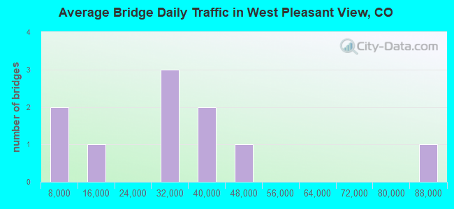
- 298,095Total average daily traffic
- 19,614Total average daily truck traffic
- National Bridge Inventory (NBI) Registered Bridges for West Pleasant View
- No street view available for this location
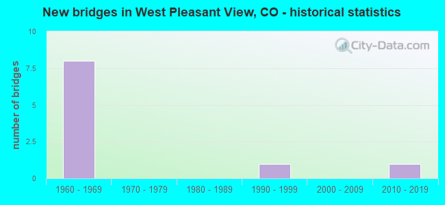
- New bridges - historical statistics
- 81960-1969
- 11990-1999
- 12010-2019
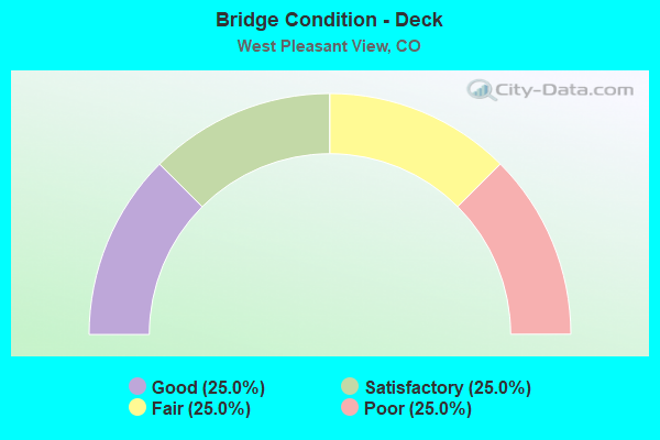
- Bridge Condition - Deck
- 25.0%Good
- 25.0%Satisfactory
- 25.0%Fair
- 25.0%Poor
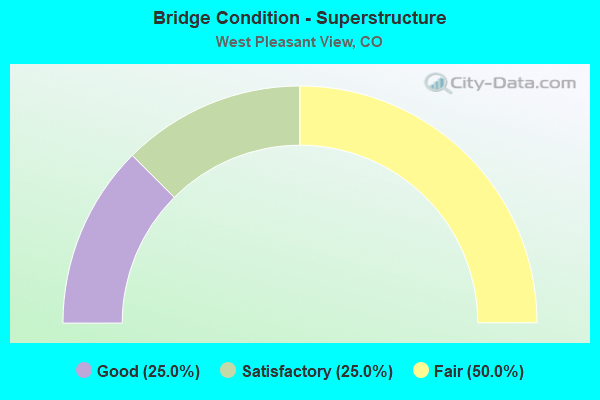
- Bridge Condition - Superstructure
- 25.0%Good
- 25.0%Satisfactory
- 50.0%Fair
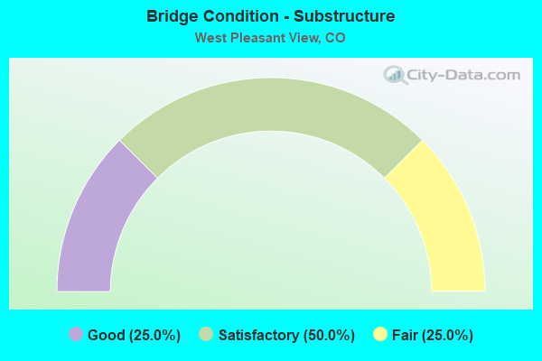
- Bridge Condition - Substructure
- 25.0%Good
- 50.0%Satisfactory
- 25.0%Fair
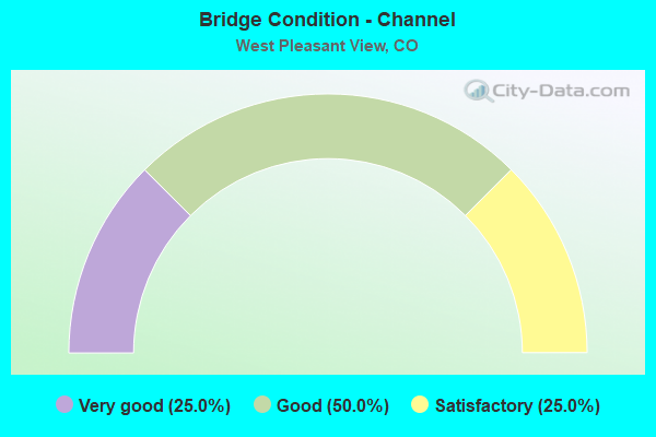
- Bridge Condition - Channel
- 25.0%Very good
- 50.0%Good
- 25.0%Satisfactory
Find on map >> Show street view
Structure Number: F-16-BB, Location: JUST E OF COLFAX EXIT (Lat: 39.731783, Lng: -105.169078), Route carried "on" structure: Interstate 70A, Year Built: 1968, Status: Open, Structure Length: 1.33m (4.36ft), Average Daily Traffic: 87,000 (year 2020), Truck Traffic: 8%, Average Future Daily Traffic: 106,140 (year 2040), Design Load: HS 20, Features Intersected: APEX GULCH, Facility Carried by Structure: I70 ML
Minimum Vertical Clearance: 30+ m (98+ ft), Kilometerpoint: 422.881, Lanes on structure: 7, Base Highway Network: Yes, Owner: State Highway Agency, Approaching Roadway Width: 34.1m (111.9ft), Skew: 15 degrees, Material/Design: Concrete, Design/Construction: Culvert, Number Of Spans In Main Unit: 2, Length of Maximum Span: 6.4m (21.0ft), Out-to-Out Width: 94.6m (310.4ft)
Condition: Channel: Good, Culverts: Satisfactory, Structural Evaluation: Equal to present minimum criteria, Waterway Adequacy: Equal to present desirable criteria, Approach Roadway Alignment: Equal to present desirable criteria, Designated Inspection Frequency: Every 24 months, Inspection Date: Febuary 2020
Find on map >> Show street view
Structure Number: F-16-HH, Location: 0.6 MI E OF JCT US 6 (Lat: 39.730583, Lng: -105.170603), Route carried "on" structure: Interstate 70A, Year Built: 1969, Status: Open, Structure Length: 11.39m (37.37ft), Average Daily Traffic: 35,000 (year 2020), Truck Traffic: 8%, Average Future Daily Traffic: 43,750 (year 2040), Design Load: HS 20+Mod, Features Intersected: US 40 ML, Facility Carried by Structure: I 70 ML EBND
Minimum Vertical Clearance: 30+ m (98+ ft), Kilometerpoint: 422.696, Lanes on structure: 3, Lanes under structure: 5, Base Highway Network: Yes, Owner: State Highway Agency, Approaching Roadway Width: 15.2m (49.9ft), Skew: 16 degrees, Material/Design: Concrete continuous, Design/Construction: Box Beam or Girders - Multiple, Number Of Spans In Main Unit: 4, Length of Maximum Span: 40.2m (131.9ft), Curb-To-Curb Width: 15.7m (51.5ft), Out-to-Out Width: 16.5m (54.1ft)
Condition: Deck: Fair, Superstructure: Fair, Substructure: Satisfactory, Operating Rating: 45.4 metric tons, Method Used To Determine Operating Rating: Load and Resistance Factor Rating (LRFR) rating reported by rating factor(RF) method using HL-93 loadings, Inventory Rating: 35.6 metric tons, Method Used To Determine Inventory Rating: Load and Resistance Factor Rating (LRFR) rating reported by rating factor(RF) method using HL-93 loadings, Structural Evaluation: Somewhat better than minimum adequacy, Deck Geometry: Somewhat better than minimum adequacy, Underclear: Somewhat better than minimum adequacy, Approach Roadway Alignment: Equal to present desirable criteria, Designated Inspection Frequency: Every 24 months, Inspection Date: April 2020, Deck Structure Type: Concrete Cast-file-Place, Wearing Surface/Protective System: Wearing Surface: Bituminous, Membrane: Preformed Fabric
Find on map >> Show street view
Structure Number: F-16-HI, Location: WEST OF DENVER (Lat: 39.730386, Lng: -105.171361), Route carried "on" structure: Interstate 70A, Year Built: 1969, Status: Open, Structure Length: 11.56m (37.93ft), Average Daily Traffic: 35,000 (year 2020), Truck Traffic: 8%, Average Future Daily Traffic: 43,750 (year 2040), Design Load: HS 20, Features Intersected: US 40 ML, Facility Carried by Structure: I 70 ML WBND
Minimum Vertical Clearance: 30+ m (98+ ft), Kilometerpoint: 422.633, Lanes on structure: 3, Lanes under structure: 6, Base Highway Network: Yes, Owner: State Highway Agency, Approaching Roadway Width: 15.2m (49.9ft), Skew: 16 degrees, Material/Design: Concrete continuous, Design/Construction: Box Beam or Girders - Multiple, Number Of Spans In Main Unit: 4, Length of Maximum Span: 41.0m (134.5ft), Curb-To-Curb Width: 15.7m (51.5ft), Out-to-Out Width: 16.5m (54.1ft)
Condition: Deck: Poor, Superstructure: Fair, Substructure: Fair, Operating Rating: 57.4 metric tons, Method Used To Determine Operating Rating: Load Factor (LF), Inventory Rating: 34.5 metric tons, Method Used To Determine Inventory Rating: Load Factor (LF), Structural Evaluation: Somewhat better than minimum adequacy, Deck Geometry: Somewhat better than minimum adequacy, Underclear: Meets minimum limits, Approach Roadway Alignment: Equal to present desirable criteria, Designated Inspection Frequency: Every 24 months, Inspection Date: April 2020, Deck Structure Type: Concrete Cast-file-Place, Wearing Surface/Protective System: Wearing Surface: Bituminous, Membrane: Preformed Fabric
Find on map >> Show street view
Structure Number: F-16-HM, Location: 3.3 MI W OF JCT SH 58 (Lat: 39.733900, Lng: -105.166911), Route carried "on" structure: Interstate 70A, Year Built: 1968, Status: Open, Structure Length: 5.31m (17.42ft), Average Daily Traffic: 43,500 (year 2020), Truck Traffic: 8%, Average Future Daily Traffic: 53,070 (year 2040), Design Load: HS 20+Mod, Features Intersected: OLD GOLDEN ROAD, Facility Carried by Structure: I 70 ML WBND
Minimum Vertical Clearance: 30+ m (98+ ft), Kilometerpoint: 423.180, Lanes on structure: 3, Lanes under structure: 2, Base Highway Network: Yes, Owner: State Highway Agency, Approaching Roadway Width: 15.2m (49.9ft), Skew: 14 degrees, Material/Design: Concrete continuous, Design/Construction: Tee Beam, Number Of Spans In Main Unit: 3, Length of Maximum Span: 24.1m (79.1ft), Curb-To-Curb Width: 15.7m (51.5ft), Out-to-Out Width: 16.5m (54.1ft)
Condition: Deck: Satisfactory, Superstructure: Satisfactory, Substructure: Satisfactory, Operating Rating: 49.9 metric tons, Method Used To Determine Operating Rating: Load Factor (LF), Inventory Rating: 30.0 metric tons, Method Used To Determine Inventory Rating: Load Factor (LF), Structural Evaluation: Equal to present minimum criteria, Deck Geometry: Somewhat better than minimum adequacy, Underclear: Meets minimum limits, Approach Roadway Alignment: Equal to present desirable criteria, Designated Inspection Frequency: Every 24 months, Inspection Date: April 2020, Deck Structure Type: Concrete Cast-file-Place, Wearing Surface/Protective System: Wearing Surface: Bituminous, Membrane: Preformed Fabric
Find on map >> Show street view
Structure Number: F-16-IX, Location: COLFAX AT I 70 EB RAMP (Lat: 39.731092, Lng: -105.169267), Route carried "on" structure: US 40C, Year Built: 1968, Status: Open, Structure Length: 0.87m (2.85ft), Average Daily Traffic: 24,000 (year 2020), Truck Traffic: 3%, Average Future Daily Traffic: 27,360 (year 2040), Design Load: HS 20, Features Intersected: APEX GULCH, Facility Carried by Structure: US 40 ML
Minimum Vertical Clearance: 30+ m (98+ ft), Kilometerpoint: 14.566, Lanes on structure: 5, Base Highway Network: Yes, Owner: State Highway Agency, Approaching Roadway Width: 25.6m (84.0ft), Skew: 2 degrees, Material/Design: Concrete, Design/Construction: Culvert, Number Of Spans In Main Unit: 2, Length of Maximum Span: 4.1m (13.5ft), Out-to-Out Width: 36.3m (119.1ft)
Condition: Channel: Satisfactory, Culverts: Satisfactory, Operating Rating: 36.3 metric tons, Method Used To Determine Operating Rating: Field evaluation and documented engineering judgment, Inventory Rating: 32.7 metric tons, Method Used To Determine Inventory Rating: Field evaluation and documented engineering judgment, Structural Evaluation: Equal to present minimum criteria, Waterway Adequacy: Equal to present desirable criteria, Approach Roadway Alignment: Equal to present desirable criteria, Designated Inspection Frequency: Every 24 months, Inspection Date: Febuary 2020
Find on map >> Show street view
Structure Number: F-21-1, Location: 0.1 mi N of S Golden Rd (Lat: 39.734750, Lng: -105.176125), Route carried "on" structure: City street , Year Built: 2012, Status: Open, Structure Length: 3.36m (11.02ft), Average Daily Traffic: 2,445 (year 2021), Truck Traffic: 2%, Average Future Daily Traffic: 2,812 (year 2041), Design Load: HL 93, Features Intersected: LENA GULCH, Facility Carried by Structure: RESEARCH ROAD
Minimum Vertical Clearance: 30.45m (99.90ft), Kilometerpoint: 0.735, Lanes on structure: 2, Owner: County Highway Agency, Approaching Roadway Width: 11.6m (38.1ft), Skew: 4 degrees, Material/Design: Prestressed concrete, Design/Construction: Stringer/Multi-beam, Number Of Spans In Main Unit: 1, Length of Maximum Span: 30.9m (101.4ft), Curb or Sidewalk Widths: Left: 2.6m (8.5ft), Right: 2.6m (8.5ft), Curb-To-Curb Width: 11.6m (38.1ft), Out-to-Out Width: 17.7m (58.1ft)
Condition: Deck: Good, Superstructure: Good, Substructure: Good, Channel: Very good, Operating Rating: 41.1 metric tons, Method Used To Determine Operating Rating: Load and Resistance Factor Rating (LRFR) rating reported by rating factor(RF) method using HL-93 loadings, Inventory Rating: 23.3 metric tons, Method Used To Determine Inventory Rating: Load and Resistance Factor Rating (LRFR) rating reported by rating factor(RF) method using HL-93 loadings, Structural Evaluation: Equal to present minimum criteria, Deck Geometry: Somewhat better than minimum adequacy, Waterway Adequacy: Equal to present desirable criteria, Approach Roadway Alignment: Equal to present desirable criteria, Designated Inspection Frequency: Every 24 months, Inspection Date: April 2021, Deck Structure Type: Concrete Cast-file-Place, Wearing Surface/Protective System: Wearing Surface: Bituminous, Membrane: Built-up, Deck Protection: Epoxy Coated Reinforcing
Find on map >> Show street view
Structure Number: F-21-114, Location: JUST S. OF 13TH AVE (Lat: 39.737269, Lng: -105.166600), Route carried "on" structure: County highway , Year Built: 1994, Status: Open, Structure Length: 1.21m (3.97ft), Average Daily Traffic: 12,150 (year 2021), Truck Traffic: 4%, Average Future Daily Traffic: 13,972 (year 2041), Design Load: HS 20, Features Intersected: LENA GULCH, Facility Carried by Structure: ISABELL ST
Minimum Vertical Clearance: 30.45m (99.90ft), Kilometerpoint: 0.381, Lanes on structure: 2, Owner: County Highway Agency, Approaching Roadway Width: 6.9m (22.6ft), Skew: 1 degrees, Material/Design: Concrete, Design/Construction: Culvert, Number Of Spans In Main Unit: 3, Length of Maximum Span: 3.8m (12.5ft), Curb or Sidewalk Widths: Left: 0.0m, Right: 0.5m (1.6ft), Curb-To-Curb Width: 12.9m (42.3ft), Out-to-Out Width: 14.0m (45.9ft)
Condition: Channel: Good, Culverts: Satisfactory, Operating Rating: 62.6 metric tons, Method Used To Determine Operating Rating: Load Factor (LF), Inventory Rating: 37.5 metric tons, Method Used To Determine Inventory Rating: Load Factor (LF), Structural Evaluation: Equal to present minimum criteria, Deck Geometry: Somewhat better than minimum adequacy, Waterway Adequacy: Equal to present desirable criteria, Approach Roadway Alignment: Equal to present desirable criteria, Designated Inspection Frequency: Every 24 months, Inspection Date: March 2021
Find on map >> Show street view
Structure Number: F-16-HH, Location: 0.6 MI E OF JCT US 6 (Lat: 39.730583, Lng: -105.170603), Route carried "under" structure: US 40C, Year Built: 1969, Structure Length: 0. m, Average Daily Traffic: 29,000 (year 2011), Truck Traffic: 4%, Features Intersected: US 40 ML, Facility Carried by Structure: I 70 ML EBND
Minimum Vertical Clearance: 5.97m (19.59ft), Kilometerpoint: 463.221, Lanes on structure: 3, Lanes under structure: 5, Material/Design: Concrete continuous, Design/Construction: Box Beam or Girders - Multiple, Length of Maximum Span: 40.2m (131.9ft)
Find on map >> Show street view
Structure Number: F-16-HI, Location: WEST OF DENVER (Lat: 39.730386, Lng: -105.171361), Route carried "under" structure: US 40C, Year Built: 1969, Structure Length: 0. m, Average Daily Traffic: 29,000 (year 2011), Truck Traffic: 4%, Features Intersected: US 40 ML, Facility Carried by Structure: I 70 ML WBND
Minimum Vertical Clearance: 5.41m (17.75ft), Kilometerpoint: 463.220, Lanes on structure: 3, Lanes under structure: 6, Material/Design: Concrete continuous, Design/Construction: Box Beam or Girders - Multiple, Length of Maximum Span: 41.0m (134.5ft)
Find on map >> Show street view
Structure Number: F-16-HM, Location: 3.3 MI W OF JCT SH 58 (Lat: 39.733900, Lng: -105.166911), Route carried "under" structure: City street , Year Built: 1968, Structure Length: 0. m, Average Daily Traffic: 1,000 (year 0000), Features Intersected: OLD GOLDEN ROAD, Facility Carried by Structure: I 70 ML WBND
Minimum Vertical Clearance: 4.85m (15.91ft), Kilometerpoint: 0.000, Lanes on structure: 3, Lanes under structure: 2, Material/Design: Concrete continuous, Design/Construction: Tee Beam, Length of Maximum Span: 24.1m (79.1ft)