Bridge Statistics for Westmoreland, New York (NY)
Condition, Traffic, Stress, Structural Evaluation, Project Costs
- National Bridge Inventory (NBI) Statistics
- 26Number of bridges
- 226ft / 68.7mTotal length
- $26,670,000Total costs
- 212,571Total average daily traffic
- 10,482Total average daily truck traffic
- National Bridge Inventory (NBI) Registered Bridges for Westmoreland
- No street view available for this location
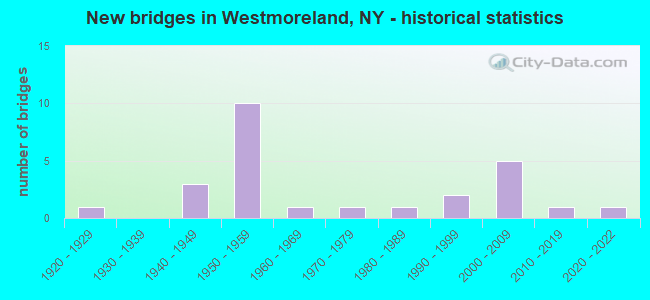
- New bridges - historical statistics
- 11920-1929
- 31940-1949
- 101950-1959
- 11960-1969
- 11970-1979
- 11980-1989
- 21990-1999
- 52000-2009
- 12010-2019
- 12020-2022
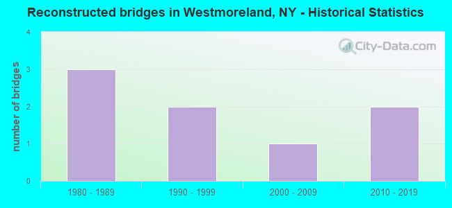
- Reconstructed bridges - Historical Statistics
- 31980-1989
- 21990-1999
- 12000-2009
- 22010-2019
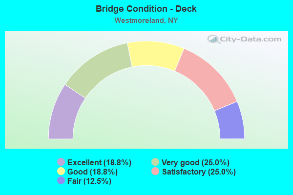
- Bridge Condition - Deck
- 18.8%Excellent
- 25.0%Very good
- 18.8%Good
- 25.0%Satisfactory
- 12.5%Fair
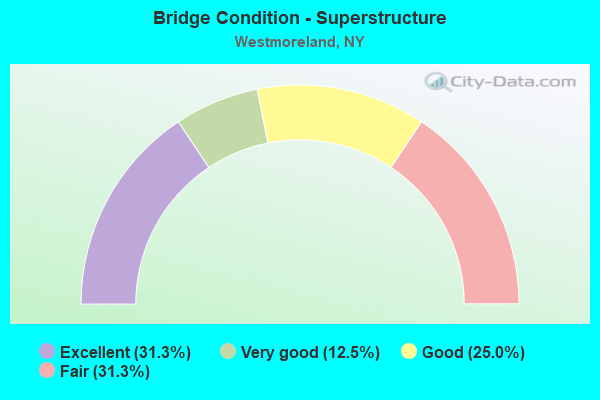
- Bridge Condition - Superstructure
- 31.3%Excellent
- 12.5%Very good
- 25.0%Good
- 31.3%Fair
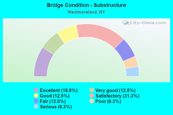
- Bridge Condition - Substructure
- 18.8%Excellent
- 12.5%Very good
- 12.5%Good
- 31.3%Satisfactory
- 12.5%Fair
- 6.3%Poor
- 6.3%Serious
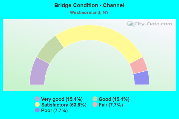
- Bridge Condition - Channel
- 15.4%Very good
- 15.4%Good
- 53.8%Satisfactory
- 7.7%Fair
- 7.7%Poor
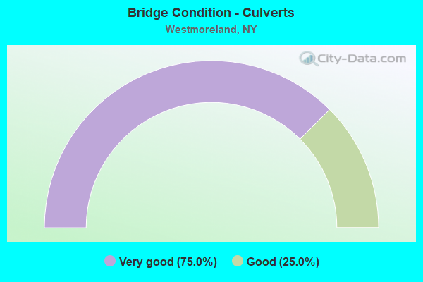
- Bridge Condition - Culverts
- 75.0%Very good
- 25.0%Good
Find on map >> Show street view
Structure Number: 101883, Location: 4 MI N JCT SH 5 & SH 26 (Lat: 43.134117, Lng: -75.500542), Route carried "on" structure: State highway 26, Year Built: 2000, Status: Open, Structure Length: 4.88m (16.01ft), Average Daily Traffic: 1,477 (year 2020), Truck Traffic: 10%, Average Future Daily Traffic: 1,540 (year 2040), Design Load: HS 25 or greater, Features Intersected: 90IX EB, RTE I90
Minimum Vertical Clearance: 30+ m (98+ ft), Kilometerpoint: 24.763, Lanes on structure: 2, Lanes under structure: 4, Base Highway Network: Yes, Owner: State Toll Authority, Approaching Roadway Width: 9.8m (32.2ft), Material/Design: Steel continuous, Design/Construction: Stringer/Multi-beam, Number Of Spans In Main Unit: 2, Length of Maximum Span: 24.1m (79.1ft), Curb-To-Curb Width: 9.6m (31.5ft), Out-to-Out Width: 10.4m (34.1ft)
Condition: Deck: Good, Superstructure: Very good, Substructure: Very good, Inventory Rating: 81.6 metric tons, Method Used To Determine Inventory Rating: Load Factor (LF), Structural Evaluation: Equal to present desirable criteria, Deck Geometry: Somewhat better than minimum adequacy, Underclear: High priority of corrective action, Approach Roadway Alignment: Equal to present desirable criteria, Length Of Structure Improvement: 4.87m (15.98ft), Designated Inspection Frequency: Every 24 months, Inspection Date: September 2020, Bridge Improvement Cost: $972,000, Roadway Improvement Cost: $569,000, Total Project Cost: $1,541,000 ( Estimate for 2021), Deck Structure Type: Concrete Cast-file-Place, Wearing Surface/Protective System: Wearing Surface: Integral Concrete, Deck Protection: Galvanized Reinforcing
Find on map >> Show street view
Structure Number: 104219, Location: 0.7 MI N OF RTE 5 & 233 (Lat: 43.090706, Lng: -75.396808), Route carried "on" structure: State highway 233, Year Built: 1999, Status: Open, Structure Length: 0.82m (2.69ft), Average Daily Traffic: 6,251 (year 2020), Truck Traffic: 10%, Average Future Daily Traffic: 7,593 (year 2040), Design Load: HS 25 or greater, Features Intersected: WILLOW BROOK
Minimum Vertical Clearance: 30+ m (98+ ft), Kilometerpoint: 6.854, Lanes on structure: 2, Base Highway Network: Yes, Owner: State Highway Agency, Approaching Roadway Width: 11.9m (39.0ft), Material/Design: Concrete, Design/Construction: Culvert, Number Of Spans In Main Unit: 1, Length of Maximum Span: 7.6m (24.9ft)
Condition: Channel: Satisfactory, Culverts: Very good, Inventory Rating: 61.7 metric tons, Method Used To Determine Inventory Rating: Load Factor (LF), Structural Evaluation: Equal to present desirable criteria, Waterway Adequacy: Somewhat better than minimum adequacy, Approach Roadway Alignment: Equal to present desirable criteria, Length Of Structure Improvement: 0.82m (2.69ft), Designated Inspection Frequency: Every 24 months, Inspection Date: October 2021, Bridge Improvement Cost: $190,000, Roadway Improvement Cost: $111,000, Total Project Cost: $302,000 ( Estimate for 2021)
Find on map >> Show street view
Structure Number: 104221, Location: 3 MI S OF EXIT 32 OF I90 (Lat: 43.115242, Lng: -75.403422), Route carried "on" structure: State highway 233, Year Built: 1927, Year Reconstructed: 1991, Status: Open, Structure Length: 2.04m (6.69ft), Average Daily Traffic: 6,251 (year 2020), Truck Traffic: 10%, Average Future Daily Traffic: 7,593 (year 2040), Design Load: HS 20, Features Intersected: DEANS CREEK
Minimum Vertical Clearance: 30+ m (98+ ft), Kilometerpoint: 9.686, Lanes on structure: 2, Base Highway Network: Yes, Owner: State Highway Agency, Approaching Roadway Width: 10.4m (34.1ft), Skew: 3 degrees, Material/Design: Steel, Design/Construction: Girder and Floorbeam System, Number Of Spans In Main Unit: 1, Length of Maximum Span: 18.2m (59.7ft), Curb or Sidewalk Widths: Left: 0.0m, Right: 1.6m (5.2ft), Curb-To-Curb Width: 9.1m (29.9ft), Out-to-Out Width: 10.0m (32.8ft)
Condition: Deck: Satisfactory, Superstructure: Fair, Substructure: Poor, Channel: Satisfactory, Operating Rating: 57.2 metric tons, Method Used To Determine Operating Rating: Load Factor (LF), Inventory Rating: 34.5 metric tons, Method Used To Determine Inventory Rating: Load Factor (LF), Structural Evaluation: Meets minimum limits, Deck Geometry: High priority of corrective action, Waterway Adequacy: Meets minimum limits, Approach Roadway Alignment: Equal to present desirable criteria, Length Of Structure Improvement: 2.04m (6.69ft), Designated Inspection Frequency: Every 24 months, Critical Feature Inspection Frequency: Every 24 months, Inspection Date: October 2021, Critical Feature Inspection Date: October 2021, Bridge Improvement Cost: $515,000, Roadway Improvement Cost: $302,000, Total Project Cost: $817,000 ( Estimate for 2021), Deck Structure Type: Concrete Cast-file-Place, Wearing Surface/Protective System: Wearing Surface: Integral Concrete, Deck Protection: Epoxy Coated Reinforcing
Find on map >> Show street view
Structure Number: 104222, Location: 0.1 MI S OF EXIT 32 (Lat: 43.118656, Lng: -75.404683), Route carried "on" structure: State highway 233, Year Built: 1999, Status: Open, Structure Length: 0.82m (2.69ft), Average Daily Traffic: 7,399 (year 2020), Truck Traffic: 10%, Average Future Daily Traffic: 8,988 (year 2040), Design Load: HS 25 or greater, Features Intersected: SUCKER BROOK
Minimum Vertical Clearance: 30+ m (98+ ft), Kilometerpoint: 10.072, Lanes on structure: 3, Base Highway Network: Yes, Owner: State Highway Agency, Approaching Roadway Width: 12.2m (40.0ft), Material/Design: Concrete, Design/Construction: Culvert, Number Of Spans In Main Unit: 1, Length of Maximum Span: 7.6m (24.9ft), Curb or Sidewalk Widths: Left: 1.5m (4.9ft), Right: 1.5m (4.9ft)
Condition: Channel: Very good, Culverts: Very good, Operating Rating: 99.8 metric tons, Method Used To Determine Operating Rating: Load Factor (LF), Inventory Rating: 59.9 metric tons, Method Used To Determine Inventory Rating: Load Factor (LF), Structural Evaluation: Equal to present desirable criteria, Waterway Adequacy: Equal to present minimum criteria, Approach Roadway Alignment: Equal to present desirable criteria, Length Of Structure Improvement: 0.82m (2.69ft), Designated Inspection Frequency: Every 24 months, Inspection Date: October 2021, Bridge Improvement Cost: $195,000, Roadway Improvement Cost: $114,000, Total Project Cost: $310,000 ( Estimate for 2021)
Find on map >> Show street view
Structure Number: 104223, Location: 3.5MI N JCT RTS 5+233 (Lat: 43.124567, Lng: -75.406925), Route carried "on" structure: State highway 233, Year Built: 1954, Year Reconstructed: 1993, Status: Open, Structure Length: 7.10m (23.29ft), Average Daily Traffic: 7,399 (year 2020), Truck Traffic: 10%, Average Future Daily Traffic: 7,433 (year 2040), Design Load: HS 20, Features Intersected: 90IX EB, RTE I90
Minimum Vertical Clearance: 30+ m (98+ ft), Kilometerpoint: 10.748, Lanes on structure: 2, Lanes under structure: 5, Base Highway Network: Yes, Owner: State Toll Authority, Approaching Roadway Width: 10.4m (34.1ft), Skew: 2 degrees, Material/Design: Steel continuous, Design/Construction: Stringer/Multi-beam, Number Of Spans In Main Unit: 4, Length of Maximum Span: 22.3m (73.2ft), Curb-To-Curb Width: 12.2m (40.0ft), Out-to-Out Width: 13.1m (43.0ft)
Condition: Deck: Good, Superstructure: Good, Substructure: Fair, Operating Rating: 59.0 metric tons, Method Used To Determine Operating Rating: Load Factor (LF), Inventory Rating: 35.4 metric tons, Method Used To Determine Inventory Rating: Load Factor (LF), Structural Evaluation: Somewhat better than minimum adequacy, Deck Geometry: Somewhat better than minimum adequacy, Underclear: High priority of corrective action, Approach Roadway Alignment: Equal to present desirable criteria, Length Of Structure Improvement: 7.10m (23.29ft), Designated Inspection Frequency: Every 24 months, Inspection Date: September 2021, Bridge Improvement Cost: $1,519,000, Roadway Improvement Cost: $889,000, Total Project Cost: $2,408,000 ( Estimate for 2021), Deck Structure Type: Concrete Cast-file-Place, Wearing Surface/Protective System: Wearing Surface: Integral Concrete, Deck Protection: Epoxy Coated Reinforcing
Find on map >> Show street view
Structure Number: 220541, Location: 1.1 MI SW OF WESTMORELAND (Lat: 43.103969, Lng: -75.416400), Route carried "on" structure: Other road , Year Built: 1958, Status: Open, Structure Length: 1.37m (4.49ft), Average Daily Traffic: 519 (year 2017), Truck Traffic: 5%, Average Future Daily Traffic: 727 (year 2037), Design Load: H 20, Features Intersected: DEANS CREEK, Facility Carried by Structure: CR42 CREASER ROAD
Minimum Vertical Clearance: 30+ m (98+ ft), Kilometerpoint: 1.368, Lanes on structure: 2, Owner: Town or Township Highway Agency, Approaching Roadway Width: 5.5m (18.0ft), Skew: 2 degrees, Material/Design: Steel, Design/Construction: Stringer/Multi-beam, Number Of Spans In Main Unit: 1, Length of Maximum Span: 13.1m (43.0ft), Curb-To-Curb Width: 7.4m (24.3ft), Out-to-Out Width: 7.7m (25.3ft)
Condition: Deck: Good, Superstructure: Fair, Substructure: Satisfactory, Channel: Satisfactory, Operating Rating: 39.0 metric tons, Method Used To Determine Operating Rating: Load Factor (LF), Inventory Rating: 22.7 metric tons, Method Used To Determine Inventory Rating: Load Factor (LF), Structural Evaluation: Somewhat better than minimum adequacy, Deck Geometry: Meets minimum limits, Waterway Adequacy: Meets minimum limits, Approach Roadway Alignment: Somewhat better than minimum adequacy, Length Of Structure Improvement: 1.37m (4.49ft), Designated Inspection Frequency: Every 24 months, Inspection Date: May 2020, Bridge Improvement Cost: $285,000, Roadway Improvement Cost: $167,000, Total Project Cost: $452,000 ( Estimate for 2021), Deck Structure Type: Concrete Cast-file-Place, Wearing Surface/Protective System: Wearing Surface: Bituminous
Find on map >> Show street view
Structure Number: 220542, Location: 2.0 MI NE OF STARKVILLE (Lat: 43.120781, Lng: -75.390289), Route carried "on" structure: Other road , Year Built: 1987, Status: Open, Structure Length: 3.14m (10.30ft), Average Daily Traffic: 4,176 (year 2017), Truck Traffic: 3%, Average Future Daily Traffic: 5,846 (year 2037), Design Load: HS 20, Features Intersected: DEANS CREEK, Facility Carried by Structure: STOP SEVEN ROAD
Minimum Vertical Clearance: 30+ m (98+ ft), Kilometerpoint: 3.266, Lanes on structure: 2, Owner: Town or Township Highway Agency, Approaching Roadway Width: 8.5m (27.9ft), Material/Design: Steel, Design/Construction: Stringer/Multi-beam, Number Of Spans In Main Unit: 1, Length of Maximum Span: 30.4m (99.7ft), Curb-To-Curb Width: 8.5m (27.9ft), Out-to-Out Width: 9.1m (29.9ft)
Condition: Deck: Very good, Superstructure: Excellent, Substructure: Very good, Channel: Good, Operating Rating: 29.2 metric tons, Method Used To Determine Operating Rating: Load and Resistance Factor Rating (LRFR) rating reported by rating factor(RF) method using HL-93 loadings, Inventory Rating: 22.4 metric tons, Method Used To Determine Inventory Rating: Load and Resistance Factor Rating (LRFR) rating reported by rating factor(RF) method using HL-93 loadings, Structural Evaluation: Somewhat better than minimum adequacy, Deck Geometry: Meets minimum limits, Waterway Adequacy: Equal to present minimum criteria, Approach Roadway Alignment: Equal to present desirable criteria, Length Of Structure Improvement: 3.13m (10.27ft), Designated Inspection Frequency: Every 24 months, Inspection Date: July 2020, Bridge Improvement Cost: $477,000, Roadway Improvement Cost: $279,000, Total Project Cost: $757,000 ( Estimate for 2021), Deck Structure Type: Concrete Cast-file-Place, Wearing Surface/Protective System: Wearing Surface: Integral Concrete, Deck Protection: Epoxy Coated Reinforcing
Find on map >> Show street view
Structure Number: 220543, Location: 1.8 MI SE OF WESTMORELAND (Lat: 43.108800, Lng: -75.368703), Route carried "on" structure: Other road , Year Built: 1966, Year Reconstructed: 1998, Status: Open, Structure Length: 2.13m (6.99ft), Average Daily Traffic: 321 (year 2019), Truck Traffic: 3%, Average Future Daily Traffic: 449 (year 2039), Design Load: HS 25 or greater, Features Intersected: ORISKANY CREEK, Facility Carried by Structure: PECKVILLE ROAD
Minimum Vertical Clearance: 30+ m (98+ ft), Kilometerpoint: 0.016, Lanes on structure: 2, Owner: Town or Township Highway Agency, Approaching Roadway Width: 7.0m (23.0ft), Material/Design: Prestressed concrete, Design/Construction: Box Beam or Girders - Multiple, Number Of Spans In Main Unit: 1, Length of Maximum Span: 19.8m (65.0ft), Curb-To-Curb Width: 7.9m (25.9ft), Out-to-Out Width: 8.6m (28.2ft)
Condition: Deck: Very good, Superstructure: Good, Substructure: Satisfactory, Channel: Poor, Operating Rating: 56.1 metric tons, Method Used To Determine Operating Rating: Load and Resistance Factor Rating (LRFR) rating reported by rating factor(RF) method using HL-93 loadings, Inventory Rating: 43.1 metric tons, Method Used To Determine Inventory Rating: Load and Resistance Factor Rating (LRFR) rating reported by rating factor(RF) method using HL-93 loadings, Structural Evaluation: Equal to present minimum criteria, Deck Geometry: Somewhat better than minimum adequacy, Waterway Adequacy: Meets minimum limits, Approach Roadway Alignment: Somewhat better than minimum adequacy, Length Of Structure Improvement: 2.13m (6.99ft), Designated Inspection Frequency: Every 24 months, Inspection Date: September 2020, Bridge Improvement Cost: $592,000, Roadway Improvement Cost: $347,000, Total Project Cost: $938,000 ( Estimate for 2021), Wearing Surface/Protective System: Wearing Surface: Bituminous, Membrane: Other
Find on map >> Show street view
Structure Number: 226737, Location: IN CLARK MILLS (Lat: 43.098522, Lng: -75.384881), Route carried "on" structure: Other road , Year Built: 1977, Status: Open, Structure Length: 0.91m (2.99ft), Average Daily Traffic: 700 (year 2016), Truck Traffic: 3%, Average Future Daily Traffic: 980 (year 2036), Features Intersected: CRYSTAL SPRING BROOK, Facility Carried by Structure: STOP SEVEN ROAD
Minimum Vertical Clearance: 30+ m (98+ ft), Kilometerpoint: 0.611, Lanes on structure: 2, Owner: Town or Township Highway Agency, Approaching Roadway Width: 6.1m (20.0ft), Material/Design: Steel, Design/Construction: Culvert, Number Of Spans In Main Unit: 2, Length of Maximum Span: 3.9m (12.8ft)
Condition: Channel: Fair, Culverts: Good, Operating Rating: 75.4 metric tons, Method Used To Determine Operating Rating: Field evaluation and documented engineering judgment, Inventory Rating: 32.7 metric tons, Method Used To Determine Inventory Rating: Field evaluation and documented engineering judgment, Structural Evaluation: Better than present minimum criteria, Waterway Adequacy: Meets minimum limits, Approach Roadway Alignment: Equal to present desirable criteria, Length Of Structure Improvement: 0.91m (2.99ft), Designated Inspection Frequency: Every 24 months, Inspection Date: July 2020, Bridge Improvement Cost: $109,000, Roadway Improvement Cost: $64,000, Total Project Cost: $172,000 ( Estimate for 2021), Wearing Surface/Protective System: Wearing Surface: Bituminous
Find on map >> Show street view
Structure Number: 331137, Location: 5 MI SW JCT RTS 233 < 365 (Lat: 43.142258, Lng: -75.511372), Route carried "on" structure: County highway , Year Built: 2008, Status: Open, Structure Length: 1.68m (5.51ft), Average Daily Traffic: 1,125 (year 2017), Truck Traffic: 7%, Average Future Daily Traffic: 1,575 (year 2037), Design Load: HS 25 or greater, Features Intersected: MUD CREEK, Facility Carried by Structure: CR52 LOWELL ROAD
Minimum Vertical Clearance: 30+ m (98+ ft), Kilometerpoint: 15.060, Lanes on structure: 2, Owner: County Highway Agency, Approaching Roadway Width: 7.9m (25.9ft), Material/Design: Prestressed concrete, Design/Construction: Box Beam or Girders - Multiple, Number Of Spans In Main Unit: 1, Length of Maximum Span: 15.6m (51.2ft), Curb-To-Curb Width: 8.0m (26.2ft), Out-to-Out Width: 9.0m (29.5ft)
Condition: Deck: Very good, Superstructure: Excellent, Substructure: Excellent, Channel: Very good, Operating Rating: 71.7 metric tons, Method Used To Determine Operating Rating: Load Factor (LF), Inventory Rating: 42.6 metric tons, Method Used To Determine Inventory Rating: Load Factor (LF), Structural Evaluation: Superior to present desirable criteria, Deck Geometry: Meets minimum limits, Waterway Adequacy: Equal to present minimum criteria, Approach Roadway Alignment: Equal to present minimum criteria, Length Of Structure Improvement: 1.67m (5.48ft), Designated Inspection Frequency: Every 24 months, Inspection Date: April 2020, Bridge Improvement Cost: $343,000, Roadway Improvement Cost: $201,000, Total Project Cost: $544,000 ( Estimate for 2021), Deck Structure Type: Concrete Cast-file-Place, Wearing Surface/Protective System: Wearing Surface: Bituminous, Deck Protection: Epoxy Coated Reinforcing
Find on map >> Show street view
Structure Number: 331138, Location: 5 MI SW JCT RTS 233 < 365 (Lat: 43.139797, Lng: -75.504347), Route carried "on" structure: County highway , Year Built: 1948, Year Reconstructed: 2017, Status: Open, Structure Length: 1.04m (3.41ft), Average Daily Traffic: 1,125 (year 2017), Truck Traffic: 7%, Average Future Daily Traffic: 1,575 (year 2037), Design Load: H 20, Features Intersected: MUD CREEK, Facility Carried by Structure: CR52 LOWELL RD
Minimum Vertical Clearance: 30+ m (98+ ft), Kilometerpoint: 15.688, Lanes on structure: 2, Owner: County Highway Agency, Approaching Roadway Width: 6.4m (21.0ft), Skew: 1 degrees, Material/Design: Prestressed concrete, Design/Construction: Box Beam or Girders - Multiple, Number Of Spans In Main Unit: 1, Length of Maximum Span: 9.8m (32.2ft), Curb-To-Curb Width: 7.7m (25.3ft), Out-to-Out Width: 8.7m (28.5ft)
Condition: Deck: Excellent, Superstructure: Excellent, Substructure: Satisfactory, Channel: Satisfactory, Inventory Rating: 64.4 metric tons, Method Used To Determine Inventory Rating: Load Factor (LF), Structural Evaluation: Equal to present minimum criteria, Deck Geometry: Meets minimum limits, Waterway Adequacy: Somewhat better than minimum adequacy, Approach Roadway Alignment: Equal to present desirable criteria, Length Of Structure Improvement: 1.03m (3.38ft), Designated Inspection Frequency: Every 24 months, Inspection Date: November 2021, Bridge Improvement Cost: $347,000, Roadway Improvement Cost: $203,000, Total Project Cost: $551,000 ( Estimate for 2021), Wearing Surface/Protective System: Wearing Surface: Bituminous, Membrane: Other
Find on map >> Show street view
Structure Number: 331139, Location: WESTMORELAND (Lat: 43.117081, Lng: -75.400969), Route carried "on" structure: County highway , Year Built: 1949, Year Reconstructed: 1997, Status: Open, Structure Length: 2.65m (8.69ft), Average Daily Traffic: 3,390 (year 2020), Truck Traffic: 8%, Average Future Daily Traffic: 4,194 (year 2040), Features Intersected: DEANS CREEK, Facility Carried by Structure: EAST MAIN STREET
Minimum Vertical Clearance: 30+ m (98+ ft), Kilometerpoint: 0.274, Lanes on structure: 2, Owner: County Highway Agency, Approaching Roadway Width: 7.3m (24.0ft), Skew: 6 degrees, Material/Design: Steel, Design/Construction: Stringer/Multi-beam, Number Of Spans In Main Unit: 1, Length of Maximum Span: 23.7m (77.8ft), Curb or Sidewalk Widths: Left: 1.5m (4.9ft), Right: 1.5m (4.9ft), Curb-To-Curb Width: 7.3m (24.0ft), Out-to-Out Width: 11.0m (36.1ft)
Condition: Deck: Satisfactory, Superstructure: Good, Substructure: Satisfactory, Channel: Satisfactory, Operating Rating: 88.9 metric tons, Method Used To Determine Operating Rating: Load Factor (LF), Inventory Rating: 53.5 metric tons, Method Used To Determine Inventory Rating: Load Factor (LF), Structural Evaluation: Equal to present minimum criteria, Deck Geometry: High priority of replacement, Waterway Adequacy: Meets minimum limits, Approach Roadway Alignment: Somewhat better than minimum adequacy, Length Of Structure Improvement: 2.65m (8.69ft), Designated Inspection Frequency: Every 24 months, Inspection Date: April 2020, Bridge Improvement Cost: $958,000, Roadway Improvement Cost: $561,000, Total Project Cost: $1,519,000 ( Estimate for 2021), Deck Structure Type: Concrete Cast-file-Place, Wearing Surface/Protective System: Wearing Surface: Bituminous, Deck Protection: Epoxy Coated Reinforcing
Find on map >> Show street view
Structure Number: 33114, Location: 2.0 MI SE OF WESTMORELAND (Lat: 43.093192, Lng: -75.393333), Route carried "on" structure: County highway , Year Built: 1945, Year Reconstructed: 2013, Status: Open, Structure Length: 0.79m (2.59ft), Average Daily Traffic: 1,786 (year 2020), Truck Traffic: 6%, Average Future Daily Traffic: 2,209 (year 2040), Design Load: HL 93, Features Intersected: BR ORISKANY CREEK, Facility Carried by Structure: CR19 SOUTH STREET
Minimum Vertical Clearance: 30+ m (98+ ft), Kilometerpoint: 5.471, Lanes on structure: 2, Owner: County Highway Agency, Approaching Roadway Width: 7.3m (24.0ft), Skew: 3 degrees, Material/Design: Concrete continuous, Design/Construction: Culvert, Number Of Spans In Main Unit: 2, Length of Maximum Span: 3.7m (12.1ft), Curb-To-Curb Width: 9.5m (31.2ft), Out-to-Out Width: 10.5m (34.4ft)
Condition: Channel: Satisfactory, Culverts: Very good, Operating Rating: 33.6 metric tons, Method Used To Determine Operating Rating: Load Factor (LF), Inventory Rating: 20.9 metric tons, Method Used To Determine Inventory Rating: Load Factor (LF), Structural Evaluation: Somewhat better than minimum adequacy, Deck Geometry: Somewhat better than minimum adequacy, Waterway Adequacy: Somewhat better than minimum adequacy, Approach Roadway Alignment: Equal to present minimum criteria, Length Of Structure Improvement: 0.79m (2.59ft), Designated Inspection Frequency: Every 24 months, Inspection Date: July 2020, Bridge Improvement Cost: $162,000, Roadway Improvement Cost: $95,000, Total Project Cost: $257,000 ( Estimate for 2021), Wearing Surface/Protective System: Wearing Surface: Bituminous
Find on map >> Show street view
Structure Number: 337111, Location: 3 Mi. SW of Rome (Lat: 43.165708, Lng: -75.462564), Route carried "on" structure: County highway , Year Built: 2014, Status: Open, Structure Length: 1.04m (3.41ft), Design Load: HL 93, Features Intersected: WHEELER CREEK, Facility Carried by Structure: CR 41 DIX Road
Minimum Vertical Clearance: 30+ m (98+ ft), Kilometerpoint: 1.512, Lanes on structure: 2, Owner: County Highway Agency, Approaching Roadway Width: 7.0m (23.0ft), Skew: 2 degrees, Material/Design: Concrete, Design/Construction: Frame, Number Of Spans In Main Unit: 1, Length of Maximum Span: 9.8m (32.2ft), Curb-To-Curb Width: 8.6m (28.2ft), Out-to-Out Width: 9.7m (31.8ft)
Condition: Deck: Excellent, Superstructure: Excellent, Substructure: Excellent, Channel: Good, Operating Rating: 78.9 metric tons, Method Used To Determine Operating Rating: Load Factor (LF), Inventory Rating: 47.2 metric tons, Method Used To Determine Inventory Rating: Load Factor (LF), Structural Evaluation: Superior to present desirable criteria, Deck Geometry: Better than present minimum criteria, Waterway Adequacy: Somewhat better than minimum adequacy, Approach Roadway Alignment: Equal to present desirable criteria, Length Of Structure Improvement: 1.03m (3.38ft), Designated Inspection Frequency: Every 24 months, Inspection Date: October 2020, Bridge Improvement Cost: $439,000, Roadway Improvement Cost: $257,000, Total Project Cost: $696,000 ( Estimate for 2021)
Find on map >> Show street view
Structure Number: 337174, Location: Westmoreland (Lat: 43.088175, Lng: -75.465650), Route carried "on" structure: County highway , Year Built: 2020, Status: Open, Structure Length: 0.99m (3.25ft), Design Load: HL 93, Features Intersected: Deans Creek, Facility Carried by Structure: Deans Highway
Minimum Vertical Clearance: 32.69m (107.25ft), Kilometerpoint: 2.011, Lanes on structure: 2, Owner: County Highway Agency, Approaching Roadway Width: 8.5m (27.9ft), Material/Design: Concrete, Design/Construction: Frame, Number Of Spans In Main Unit: 1, Length of Maximum Span: 9.1m (29.9ft), Curb-To-Curb Width: 8.5m (27.9ft), Out-to-Out Width: 9.5m (31.2ft)
Condition: Deck: Excellent, Superstructure: Excellent, Substructure: Excellent, Channel: Satisfactory, Operating Rating: 85.3 metric tons, Method Used To Determine Operating Rating: Load Factor (LF), Inventory Rating: 50.8 metric tons, Method Used To Determine Inventory Rating: Load Factor (LF), Structural Evaluation: Superior to present desirable criteria, Deck Geometry: Better than present minimum criteria, Waterway Adequacy: Somewhat better than minimum adequacy, Approach Roadway Alignment: Equal to present desirable criteria, Designated Inspection Frequency: Every 24 months, Inspection Date: April 2021, Wearing Surface/Protective System: Wearing Surface: Bituminous
Find on map >> Show street view
Structure Number: 551287, Location: EXIT 32 OF I90 (Lat: 43.124017, Lng: -75.401389), Route carried "on" structure: Ramp Interstate , Year Built: 2002, Status: Open, Structure Length: 7.47m (24.51ft), Average Daily Traffic: 2,692 (year 2018), Truck Traffic: 28%, Average Future Daily Traffic: 3,101 (year 2040), Design Load: HS 25 or greater, Features Intersected: 90IX EB, RTE I90, Facility Carried by Structure: EXIT 32 RAMP
Minimum Vertical Clearance: 30+ m (98+ ft), Kilometerpoint: 0.161, Lanes on structure: 2, Lanes under structure: 5, Toll: On Interstate toll segment, Owner: State Toll Authority, Approaching Roadway Width: 14.9m (48.9ft), Skew: 20 degrees, Material/Design: Steel continuous, Design/Construction: Stringer/Multi-beam, Number Of Spans In Main Unit: 2, Length of Maximum Span: 36.9m (121.1ft), Curb-To-Curb Width: 14.8m (48.6ft), Out-to-Out Width: 15.9m (52.2ft)
Condition: Deck: Very good, Superstructure: Very good, Substructure: Fair, Operating Rating: 46.7 metric tons, Method Used To Determine Operating Rating: Load and Resistance Factor Rating (LRFR) rating reported by rating factor(RF) method using HL-93 loadings, Inventory Rating: 36.0 metric tons, Method Used To Determine Inventory Rating: Load and Resistance Factor Rating (LRFR) rating reported by rating factor(RF) method using HL-93 loadings, Structural Evaluation: Somewhat better than minimum adequacy, Deck Geometry: Superior to present desirable criteria, Underclear: Meets minimum limits, Approach Roadway Alignment: Equal to present desirable criteria, Length Of Structure Improvement: 7.46m (24.48ft), Designated Inspection Frequency: Every 24 months, Inspection Date: September 2020, Bridge Improvement Cost: $1,713,000, Roadway Improvement Cost: $1,003,000, Total Project Cost: $2,716,000 ( Estimate for 2021), Deck Structure Type: Concrete Cast-file-Place, Wearing Surface/Protective System: Wearing Surface: Integral Concrete, Deck Protection: Galvanized Reinforcing
Find on map >> Show street view
Structure Number: 551294, Location: 4.7 MI W EXIT 32 OF I90 (Lat: 43.135867, Lng: -75.488350), Route carried "on" structure: County highway , Year Built: 1953, Year Reconstructed: 1994, Status: Open, Structure Length: 8.56m (28.08ft), Average Daily Traffic: 942 (year 2016), Truck Traffic: 6%, Average Future Daily Traffic: 1,319 (year 2036), Design Load: HS 20, Features Intersected: 90IX EB, RTE I90, Facility Carried by Structure: LOWELL RD CR 52
Minimum Vertical Clearance: 30+ m (98+ ft), Kilometerpoint: 17.055, Lanes on structure: 2, Lanes under structure: 4, Owner: State Toll Authority, Approaching Roadway Width: 6.7m (22.0ft), Skew: 4 degrees, Material/Design: Steel, Design/Construction: Stringer/Multi-beam, Number Of Spans In Main Unit: 4, Length of Maximum Span: 25.3m (83.0ft), Curb or Sidewalk Widths: Left: 0.7m (2.3ft), Right: 0.7m (2.3ft), Curb-To-Curb Width: 7.9m (25.9ft), Out-to-Out Width: 10.1m (33.1ft)
Condition: Deck: Satisfactory, Superstructure: Fair, Substructure: Good, Operating Rating: 54.4 metric tons, Method Used To Determine Operating Rating: Load Factor (LF), Inventory Rating: 32.7 metric tons, Method Used To Determine Inventory Rating: Load Factor (LF), Structural Evaluation: Somewhat better than minimum adequacy, Deck Geometry: Somewhat better than minimum adequacy, Underclear: High priority of corrective action, Approach Roadway Alignment: Equal to present desirable criteria, Length Of Structure Improvement: 8.56m (28.08ft), Designated Inspection Frequency: Every 24 months, Inspection Date: August 2020, Bridge Improvement Cost: $1,389,000, Roadway Improvement Cost: $814,000, Total Project Cost: $2,203,000 ( Estimate for 2021), Deck Structure Type: Concrete Cast-file-Place, Wearing Surface/Protective System: Wearing Surface: Bituminous, Membrane: Preformed Fabric
Find on map >> Show street view
Structure Number: 551295, Location: 2.05 MI W INT 32 ON I-90 (Lat: 43.127908, Lng: -75.437914), Route carried "on" structure: County highway , Year Built: 1954, Status: Open, Structure Length: 7.10m (23.29ft), Average Daily Traffic: 571 (year 2018), Truck Traffic: 8%, Average Future Daily Traffic: 799 (year 2038), Design Load: HS 20+Mod, Features Intersected: 90IX EB, RTE I90, Facility Carried by Structure: BARTLETT RD CR 42
Minimum Vertical Clearance: 30+ m (98+ ft), Kilometerpoint: 1.802, Lanes on structure: 2, Lanes under structure: 4, Owner: State Toll Authority, Approaching Roadway Width: 6.7m (22.0ft), Skew: 3 degrees, Material/Design: Steel, Design/Construction: Stringer/Multi-beam, Number Of Spans In Main Unit: 4, Length of Maximum Span: 20.7m (67.9ft), Curb or Sidewalk Widths: Left: 0.8m (2.6ft), Right: 0.8m (2.6ft), Curb-To-Curb Width: 7.9m (25.9ft), Out-to-Out Width: 10.1m (33.1ft)
Condition: Deck: Fair, Superstructure: Good, Substructure: Satisfactory, Operating Rating: 72.6 metric tons, Method Used To Determine Operating Rating: Load Factor (LF), Inventory Rating: 43.5 metric tons, Method Used To Determine Inventory Rating: Load Factor (LF), Structural Evaluation: Equal to present minimum criteria, Deck Geometry: Somewhat better than minimum adequacy, Underclear: High priority of corrective action, Approach Roadway Alignment: Equal to present desirable criteria, Length Of Structure Improvement: 7.10m (23.29ft), Designated Inspection Frequency: Every 24 months, Inspection Date: June 2020, Bridge Improvement Cost: $1,162,000, Roadway Improvement Cost: $680,000, Total Project Cost: $1,842,000 ( Estimate for 2021), Deck Structure Type: Concrete Cast-file-Place, Wearing Surface/Protective System: Wearing Surface: Bituminous, Membrane: Other
Find on map >> Show street view
Structure Number: 5512969, Location: 1.65 MI W INT 32 ON I-90 (Lat: 43.127547, Lng: -75.429792), Route carried "on" structure: Interstate 90, Year Built: 1954, Status: Open, Structure Length: 7.16m (23.49ft), Average Daily Traffic: 23,711 (year 2020), Truck Traffic: 25%, Average Future Daily Traffic: 26,373 (year 2040), Design Load: HS 20+Mod, Features Intersected: NYO&W RR (ABAND)
Minimum Vertical Clearance: 30+ m (98+ ft), Kilometerpoint: 18.632, Lanes on structure: 4, Base Highway Network: Yes, Toll: On Interstate toll segment, Owner: State Toll Authority, Approaching Roadway Width: 23.2m (76.1ft), Skew: 35 degrees, Material/Design: Steel continuous, Design/Construction: Stringer/Multi-beam, Number Of Spans In Main Unit: 3, Length of Maximum Span: 27.4m (89.9ft), Curb or Sidewalk Widths: Left: 0.9m (3.0ft), Right: 0.9m (3.0ft), Curb-To-Curb Width: 29.9m (98.1ft), Out-to-Out Width: 34.4m (112.9ft)
Condition: Deck: Fair, Superstructure: Fair, Substructure: Serious, Operating Rating: 55.3 metric tons, Method Used To Determine Operating Rating: Load Factor (LF), Inventory Rating: 32.7 metric tons, Method Used To Determine Inventory Rating: Load Factor (LF), Structural Evaluation: High priority of corrective action, Deck Geometry: Superior to present desirable criteria, Approach Roadway Alignment: Equal to present desirable criteria, Length Of Structure Improvement: 7.16m (23.49ft), Designated Inspection Frequency: Every 12 months, Inspection Date: June 2021, Bridge Improvement Cost: $4,327,000, Roadway Improvement Cost: $2,534,000, Total Project Cost: $6,861,000 ( Estimate for 2021), Deck Structure Type: Concrete Cast-file-Place, Wearing Surface/Protective System: Wearing Surface: Bituminous
Find on map >> Show street view
Structure Number: 551297, Location: 10 MI W EXIT 31 OF I90 (Lat: 43.122728, Lng: -75.389917), Route carried "on" structure: County highway , Year Built: 1952, Year Reconstructed: 2018, Status: Open, Structure Length: 6.98m (22.90ft), Average Daily Traffic: 1,408 (year 2020), Truck Traffic: 8%, Average Future Daily Traffic: 1,742 (year 2040), Design Load: HS 20+Mod, Features Intersected: 90IX EB, RTE I90, Facility Carried by Structure: CIDER ST CR 23
Minimum Vertical Clearance: 30+ m (98+ ft), Kilometerpoint: 0.917, Lanes on structure: 2, Lanes under structure: 4, Owner: State Toll Authority, Approaching Roadway Width: 6.7m (22.0ft), Skew: 2 degrees, Material/Design: Steel, Design/Construction: Stringer/Multi-beam, Number Of Spans In Main Unit: 4, Length of Maximum Span: 21.0m (68.9ft), Curb or Sidewalk Widths: Left: 0.8m (2.6ft), Right: 0.8m (2.6ft), Curb-To-Curb Width: 7.9m (25.9ft), Out-to-Out Width: 10.1m (33.1ft)
Condition: Deck: Satisfactory, Superstructure: Fair, Substructure: Good, Operating Rating: 68.9 metric tons, Method Used To Determine Operating Rating: Load Factor (LF), Inventory Rating: 40.8 metric tons, Method Used To Determine Inventory Rating: Load Factor (LF), Structural Evaluation: Somewhat better than minimum adequacy, Deck Geometry: Meets minimum limits, Underclear: High priority of corrective action, Approach Roadway Alignment: Equal to present minimum criteria, Length Of Structure Improvement: 6.97m (22.87ft), Designated Inspection Frequency: Every 24 months, Inspection Date: June 2020, Bridge Improvement Cost: $1,125,000, Roadway Improvement Cost: $659,000, Total Project Cost: $1,784,000 ( Estimate for 2021), Deck Structure Type: Concrete Cast-file-Place, Wearing Surface/Protective System: Wearing Surface: Bituminous
Find on map >> Show street view
Structure Number: 101883, Location: 4 MI N JCT SH 5 & SH 26 (Lat: 43.134117, Lng: -75.500542), Route carried "under" structure: Interstate 90, Year Built: 2000, Structure Length: 0. m, Average Daily Traffic: 27,100 (year 1999), Features Intersected: 90IX EB, RTE I90, Facility Carried by Structure: RTE 26
Minimum Vertical Clearance: 4.45m (14.60ft), Kilometerpoint: 399.837, Lanes on structure: 2, Lanes under structure: 2, Toll: On Interstate toll segment, Material/Design: Steel continuous, Design/Construction: Stringer/Multi-beam, Length of Maximum Span: 24.1m (79.1ft)
Find on map >> Show street view
Structure Number: 104223, Location: 3.5MI N JCT RTS 5+233 (Lat: 43.124567, Lng: -75.406925), Route carried "under" structure: Interstate 90, Year Built: 1954, Structure Length: 0. m, Average Daily Traffic: 13,300 (year 1979), Features Intersected: 90IX EB, RTE I90, Facility Carried by Structure: RTE 233
Minimum Vertical Clearance: 5.11m (16.77ft), Kilometerpoint: 392.049, Lanes on structure: 2, Lanes under structure: 2, Toll: On Interstate toll segment, Material/Design: Steel continuous, Design/Construction: Stringer/Multi-beam, Length of Maximum Span: 22.3m (73.2ft)
Find on map >> Show street view
Structure Number: 551287, Location: EXIT 32 OF I90 (Lat: 43.124017, Lng: -75.401389), Route carried "under" structure: Interstate 90, Year Built: 2002, Structure Length: 0. m, Average Daily Traffic: 25,000 (year 2001), Features Intersected: 90IX EB, RTE I90, Facility Carried by Structure: EXIT 32 RAMP
Minimum Vertical Clearance: 5.05m (16.57ft), Kilometerpoint: 391.309, Lanes on structure: 2, Lanes under structure: 3, Toll: On Interstate toll segment, Material/Design: Steel continuous, Design/Construction: Stringer/Multi-beam, Length of Maximum Span: 36.9m (121.1ft)
Find on map >> Show street view
Structure Number: 551294, Location: 4.7 MI W EXIT 32 OF I90 (Lat: 43.135867, Lng: -75.488350), Route carried "under" structure: Interstate 90, Year Built: 1953, Structure Length: 0. m, Average Daily Traffic: 26,851 (year 2015), Features Intersected: 90IX EB, RTE I90, Facility Carried by Structure: LOWELL RD CR 52
Minimum Vertical Clearance: 4.55m (14.93ft), Kilometerpoint: 398.807, Lanes on structure: 2, Lanes under structure: 2, Toll: On Interstate toll segment, Material/Design: Steel, Design/Construction: Stringer/Multi-beam, Length of Maximum Span: 25.3m (83.0ft)
Find on map >> Show street view
Structure Number: 551295, Location: 2.05 MI W INT 32 ON I-90 (Lat: 43.127908, Lng: -75.437914), Route carried "under" structure: Interstate 90, Year Built: 1954, Structure Length: 0. m, Average Daily Traffic: 26,851 (year 2015), Features Intersected: 90IX EB, RTE I90, Facility Carried by Structure: BARTLETT RD CR 42
Minimum Vertical Clearance: 4.88m (16.01ft), Kilometerpoint: 394.607, Lanes on structure: 2, Lanes under structure: 2, Toll: On Interstate toll segment, Material/Design: Steel, Design/Construction: Stringer/Multi-beam, Length of Maximum Span: 20.7m (67.9ft)
Find on map >> Show street view
Structure Number: 551297, Location: 10 MI W EXIT 31 OF I90 (Lat: 43.122728, Lng: -75.389917), Route carried "under" structure: Interstate 90, Year Built: 1952, Structure Length: 0. m, Average Daily Traffic: 22,226 (year 2015), Features Intersected: 90IX EB, RTE I90, Facility Carried by Structure: CIDER ST CR 23
Minimum Vertical Clearance: 4.98m (16.34ft), Kilometerpoint: 390.649, Lanes on structure: 2, Lanes under structure: 2, Toll: On Interstate toll segment, Material/Design: Steel, Design/Construction: Stringer/Multi-beam, Length of Maximum Span: 21.0m (68.9ft)