Bridge Statistics for Westphalia, Maryland (MD)
Condition, Traffic, Stress, Structural Evaluation, Project Costs
- National Bridge Inventory (NBI) Statistics
- 12Number of bridges
- 108ft / 32.6mTotal length
- $4,100,000Total costs
- 1,204,353Total average daily traffic
- 56,323Total average daily truck traffic
- National Bridge Inventory (NBI) Registered Bridges for Westphalia
- No street view available for this location
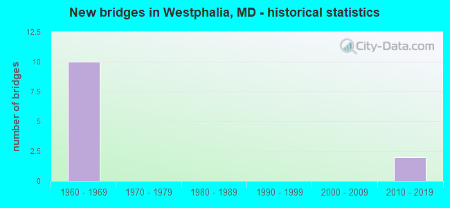
- New bridges - historical statistics
- 101960-1969
- 22010-2019
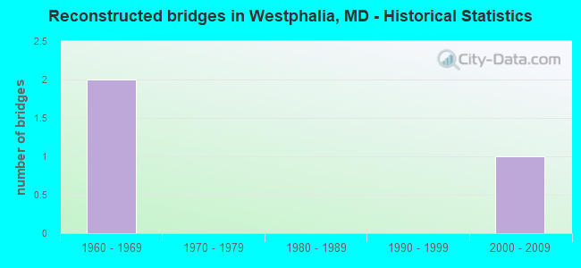
- Reconstructed bridges - Historical Statistics
- 21960-1969
- 01970-1979
- 01980-1989
- 01990-1999
- 12000-2009
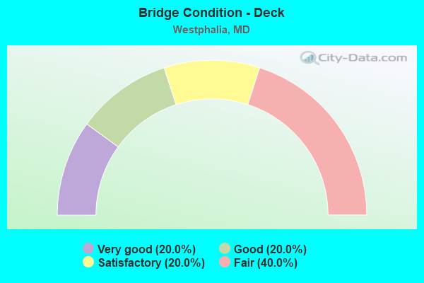
- Bridge Condition - Deck
- 20.0%Very good
- 20.0%Good
- 20.0%Satisfactory
- 40.0%Fair
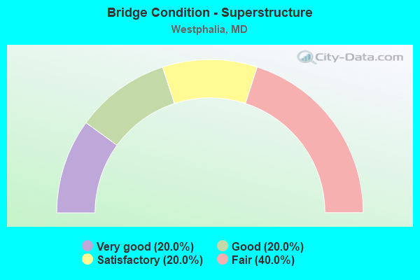
- Bridge Condition - Superstructure
- 20.0%Very good
- 20.0%Good
- 20.0%Satisfactory
- 40.0%Fair
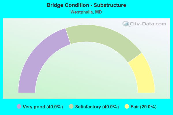
- Bridge Condition - Substructure
- 40.0%Very good
- 40.0%Satisfactory
- 20.0%Fair
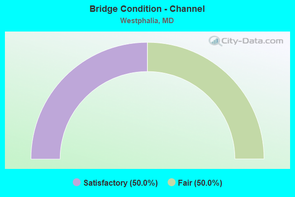
- Bridge Condition - Channel
- 50.0%Satisfactory
- 50.0%Fair
Find on map >> Show street view
Structure Number: 100000160157015, Location: 1.64 MILES S OF MD 214 (Lat: 38.868772, Lng: -76.844317), Route carried "on" structure: Interstate 95, Year Built: 1964, Status: Open, Structure Length: 3.29m (10.79ft), Average Daily Traffic: 201,196 (year 2009), Truck Traffic: 8%, Average Future Daily Traffic: 301,794 (year 2028), Design Load: HS 20, Features Intersected: RITCHIE MARLBORO ROAD
Minimum Vertical Clearance: 30+ m (98+ ft), Kilometerpoint: 21.126, Lanes on structure: 4, Lanes under structure: 2, Base Highway Network: Yes, Owner: State Highway Agency, Approaching Roadway Width: 21.9m (71.9ft), Skew: 1 degrees, Material/Design: Steel, Design/Construction: Stringer/Multi-beam, Number Of Spans In Main Unit: 3, Length of Maximum Span: 19.8m (65.0ft), Curb-To-Curb Width: 20.7m (67.9ft), Out-to-Out Width: 21.3m (69.9ft)
Condition: Deck: Satisfactory, Superstructure: Fair, Substructure: Satisfactory, Operating Rating: 61.7 metric tons, Method Used To Determine Operating Rating: Load Factor (LF), Inventory Rating: 37.2 metric tons, Method Used To Determine Inventory Rating: Load Factor (LF), Structural Evaluation: Somewhat better than minimum adequacy, Deck Geometry: Equal to present minimum criteria, Underclear: Equal to present minimum criteria, Approach Roadway Alignment: Equal to present desirable criteria, Length Of Structure Improvement: 3.29m (10.79ft), Designated Inspection Frequency: Every 24 months, Inspection Date: August 2021, Bridge Improvement Cost: $907,000, Roadway Improvement Cost: $91,000, Total Project Cost: $998,000, Deck Structure Type: Concrete Cast-file-Place, Wearing Surface/Protective System: Wearing Surface: Bituminous
Find on map >> Show street view
Structure Number: 100000160159015, Location: 3.48 MILES NORTH OF MD 5 (Lat: 38.839483, Lng: -76.866756), Route carried "on" structure: Interstate 95, Year Built: 1963, Year Reconstructed: 1971, Status: Open, Structure Length: 6.71m (22.01ft), Average Daily Traffic: 201,196 (year 2009), Truck Traffic: 8%, Average Future Daily Traffic: 238,750 (year 2029), Design Load: HS 20, Features Intersected: MD 4
Minimum Vertical Clearance: 30+ m (98+ ft), Kilometerpoint: 17.282, Lanes on structure: 5, Lanes under structure: 4, Base Highway Network: Yes, Owner: State Highway Agency, Approaching Roadway Width: 20.7m (67.9ft), Material/Design: Steel, Design/Construction: Stringer/Multi-beam, Number Of Spans In Main Unit: 4, Length of Maximum Span: 22.3m (73.2ft), Curb-To-Curb Width: 20.1m (65.9ft), Out-to-Out Width: 21.7m (71.2ft)
Condition: Deck: Fair, Superstructure: Fair, Substructure: Satisfactory, Operating Rating: 67.1 metric tons, Method Used To Determine Operating Rating: Load Factor (LF), Inventory Rating: 40.4 metric tons, Method Used To Determine Inventory Rating: Load Factor (LF), Structural Evaluation: Somewhat better than minimum adequacy, Deck Geometry: Meets minimum limits, Underclear: Somewhat better than minimum adequacy, Approach Roadway Alignment: Equal to present desirable criteria, Length Of Structure Improvement: 6.71m (22.01ft), Designated Inspection Frequency: Every 24 months, Inspection Date: October 2021, Bridge Improvement Cost: $940,000, Roadway Improvement Cost: $94,000, Total Project Cost: $1,034,000, Deck Structure Type: Concrete Cast-file-Place, Wearing Surface/Protective System: Wearing Surface: Bituminous
Find on map >> Show street view
Structure Number: 100000160159016, Location: 3.48 MILES NORTH OF MD 5 (Lat: 38.840103, Lng: -76.866719), Route carried "on" structure: Interstate 95, Year Built: 1963, Year Reconstructed: 1971, Status: Open, Structure Length: 6.71m (22.01ft), Average Daily Traffic: 201,196 (year 2009), Truck Traffic: 8%, Average Future Daily Traffic: 238,750 (year 2029), Design Load: HS 20, Features Intersected: MD 4
Minimum Vertical Clearance: 30+ m (98+ ft), Kilometerpoint: 17.282, Lanes on structure: 4, Lanes under structure: 4, Base Highway Network: Yes, Owner: State Highway Agency, Approaching Roadway Width: 20.7m (67.9ft), Material/Design: Steel, Design/Construction: Stringer/Multi-beam, Number Of Spans In Main Unit: 4, Length of Maximum Span: 22.3m (73.2ft), Curb-To-Curb Width: 20.1m (65.9ft), Out-to-Out Width: 21.7m (71.2ft)
Condition: Deck: Fair, Superstructure: Satisfactory, Substructure: Fair, Operating Rating: 65.3 metric tons, Method Used To Determine Operating Rating: Load Factor (LF), Inventory Rating: 39.0 metric tons, Method Used To Determine Inventory Rating: Load Factor (LF), Structural Evaluation: Somewhat better than minimum adequacy, Deck Geometry: Equal to present minimum criteria, Underclear: Somewhat better than minimum adequacy, Approach Roadway Alignment: Equal to present desirable criteria, Length Of Structure Improvement: 6.71m (22.01ft), Designated Inspection Frequency: Every 24 months, Inspection Date: October 2021, Bridge Improvement Cost: $1,880,000, Roadway Improvement Cost: $188,000, Total Project Cost: $2,068,000, Deck Structure Type: Concrete Cast-file-Place, Wearing Surface/Protective System: Wearing Surface: Bituminous
Find on map >> Show street view
Structure Number: 10000016016101, Location: 2.37 MI N OF MD 5 (Lat: 38.826858, Lng: -76.878278), Route carried "on" structure: County highway 483, Year Built: 1963, Year Reconstructed: 2011, Status: Open, Structure Length: 8.05m (26.41ft), Average Daily Traffic: 11,800 (year 2007), Truck Traffic: 6%, Average Future Daily Traffic: 17,500 (year 2030), Design Load: HS 20, Features Intersected: IS 95, Facility Carried by Structure: FORESTVILLE RD
Minimum Vertical Clearance: 30+ m (98+ ft), Kilometerpoint: 1.207, Lanes on structure: 2, Lanes under structure: 8, Owner: State Highway Agency, Approaching Roadway Width: 13.4m (44.0ft), Skew: 1 degrees, Material/Design: Steel, Design/Construction: Stringer/Multi-beam, Number Of Spans In Main Unit: 2, Number Of Approach Spans: 2, Length of Maximum Span: 29.9m (98.1ft), Curb or Sidewalk Widths: Left: 0.0m, Right: 1.6m (5.2ft), Curb-To-Curb Width: 9.6m (31.5ft), Out-to-Out Width: 12.3m (40.4ft)
Condition: Deck: Very good, Superstructure: Good, Substructure: Very good, Operating Rating: 65.8 metric tons, Method Used To Determine Operating Rating: Load Factor (LF), Inventory Rating: 39.5 metric tons, Method Used To Determine Inventory Rating: Load Factor (LF), Structural Evaluation: Better than present minimum criteria, Deck Geometry: Meets minimum limits, Underclear: High priority of corrective action, Approach Roadway Alignment: Equal to present desirable criteria, Designated Inspection Frequency: Every 24 months, Inspection Date: March 2020, Deck Structure Type: Concrete Cast-file-Place, Wearing Surface/Protective System: Wearing Surface: Integral Concrete
Find on map >> Show street view
Structure Number: 10000016017803, Location: 0.71 MILE SOUTH OF MD 4 (Lat: 38.831000, Lng: -76.873097), Route carried "on" structure: Interstate 95, Year Built: 1962, Status: Open, Structure Length: 0.79m (2.59ft), Average Daily Traffic: 185,190 (year 2009), Average Future Daily Traffic: 238,750 (year 2029), Design Load: HS 20+Mod, Features Intersected: HENSON CREEK
Minimum Vertical Clearance: 30+ m (98+ ft), Kilometerpoint: 16.174, Lanes on structure: 8, Base Highway Network: Yes, Owner: State Highway Agency, Approaching Roadway Width: 56.7m (186.0ft), Skew: 2 degrees, Material/Design: Steel, Design/Construction: Culvert, Length of Maximum Span: 3.4m (11.2ft)
Condition: Channel: Satisfactory, Culverts: Satisfactory, Structural Evaluation: Equal to present minimum criteria, Waterway Adequacy: Equal to present desirable criteria, Approach Roadway Alignment: Equal to present desirable criteria, Designated Inspection Frequency: Every 24 months, Inspection Date: March 2021
Find on map >> Show street view
Structure Number: 100000160181012, Location: 1.37 MILES S OF MD 4PB (Lat: 38.813842, Lng: -76.825422), Route carried "on" structure: State highway 4, Year Built: 2014, Status: Open, Structure Length: 6.40m (21.00ft), Average Daily Traffic: 63,050 (year 2011), Truck Traffic: 9%, Average Future Daily Traffic: 90,900 (year 2031), Features Intersected: MD 223
Minimum Vertical Clearance: 30+ m (98+ ft), Kilometerpoint: 10.121, Lanes on structure: 2, Lanes under structure: 5, Base Highway Network: Yes, Owner: State Highway Agency, Approaching Roadway Width: 11.6m (38.1ft), Skew: 2 degrees, Material/Design: Steel continuous, Design/Construction: Stringer/Multi-beam, Number Of Spans In Main Unit: 2, Length of Maximum Span: 32.0m (105.0ft), Curb-To-Curb Width: 17.7m (58.1ft), Out-to-Out Width: 18.9m (62.0ft)
Condition: Deck: Good, Superstructure: Very good, Substructure: Very good, Operating Rating: 76.1 metric tons, Method Used To Determine Operating Rating: Load and Resistance Factor Rating (LRFR) rating reported by rating factor(RF) method using HL-93 loadings, Inventory Rating: 58.3 metric tons, Method Used To Determine Inventory Rating: Load and Resistance Factor Rating (LRFR) rating reported by rating factor(RF) method using HL-93 loadings, Structural Evaluation: Equal to present desirable criteria, Deck Geometry: Superior to present desirable criteria, Underclear: Meets minimum limits, Approach Roadway Alignment: Equal to present desirable criteria, Designated Inspection Frequency: Every 24 months, Inspection Date: November 2020, Deck Structure Type: Concrete Cast-file-Place, Wearing Surface/Protective System: Wearing Surface: Integral Concrete, Deck Protection: Epoxy Coated Reinforcing
Find on map >> Show street view
Structure Number: 200000P-051403, Location: 1.0 MILE NORTH OF MD 4 (Lat: 38.818103, Lng: -76.812694), Route carried "on" structure: County highway 2059, Year Built: 1968, Status: Open, Structure Length: 0.64m (2.10ft), Average Daily Traffic: 3,200 (year 2015), Truck Traffic: 3%, Average Future Daily Traffic: 4,755 (year 2035), Features Intersected: BACK BRANCH, Facility Carried by Structure: ROBLEE DRIVE
Minimum Vertical Clearance: 30+ m (98+ ft), Kilometerpoint: 0.000, Lanes on structure: 2, Owner: County Highway Agency, Approaching Roadway Width: 11.0m (36.1ft), Skew: 1 degrees, Material/Design: Steel, Design/Construction: Culvert, Length of Maximum Span: 3.0m (9.8ft)
Condition: Channel: Fair, Culverts: Satisfactory, Operating Rating: 57.1 metric tons, Method Used To Determine Operating Rating: Load Factor (LF), Inventory Rating: 34.0 metric tons, Method Used To Determine Inventory Rating: Load Factor (LF), Structural Evaluation: Equal to present minimum criteria, Waterway Adequacy: Better than present minimum criteria, Approach Roadway Alignment: Equal to present minimum criteria, Designated Inspection Frequency: Every 24 months, Inspection Date: July 2021, Wearing Surface/Protective System: Wearing Surface: Bituminous
Find on map >> Show street view
Structure Number: 100000160157015, Location: 0.138 M S OF ROUNDABOUT (Lat: 38.868772, Lng: -76.844317), Route carried "under" structure: State highway 221A, Year Built: 1964, Structure Length: 0. m, Average Daily Traffic: 8,891 (year 2009), Features Intersected: MD 221A-RITCHIE MARLBORO, Facility Carried by Structure: IS 95 IL
Minimum Vertical Clearance: 5.49m (18.01ft), Kilometerpoint: 8.853, Lanes on structure: 4, Lanes under structure: 2, Material/Design: Steel, Design/Construction: Stringer/Multi-beam, Length of Maximum Span: 19.8m (65.0ft)
Find on map >> Show street view
Structure Number: 100000160159015, Location: 0.98 MILE NORTH OF MD 337 (Lat: 38.839483, Lng: -76.866756), Route carried "under" structure: State highway 4, Year Built: 1963, Structure Length: 0. m, Average Daily Traffic: 58,722 (year 2009), Features Intersected: MD 4
Minimum Vertical Clearance: 4.88m (16.01ft), Kilometerpoint: 15.076, Lanes on structure: 4, Lanes under structure: 4, Material/Design: Steel, Design/Construction: Stringer/Multi-beam, Length of Maximum Span: 22.3m (73.2ft)
Find on map >> Show street view
Structure Number: 100000160159016, Location: 0.98 MILE NORTH OF MD 337 (Lat: 38.840103, Lng: -76.866719), Route carried "under" structure: State highway 4, Year Built: 1963, Structure Length: 0. m, Average Daily Traffic: 58,722 (year 2009), Features Intersected: MD 4
Minimum Vertical Clearance: 4.88m (16.01ft), Kilometerpoint: 15.076, Lanes on structure: 4, Lanes under structure: 4, Material/Design: Steel, Design/Construction: Stringer/Multi-beam, Length of Maximum Span: 22.3m (73.2ft)
Find on map >> Show street view
Structure Number: 10000016016101, Location: 2.39 MILES NORTH OF MD 5 (Lat: 38.826858, Lng: -76.878278), Route carried "under" structure: Interstate 95, Year Built: 1963, Structure Length: 0. m, Average Daily Traffic: 185,190 (year 2009), Features Intersected: IS 95, Facility Carried by Structure: FORESTVILLE RD
Minimum Vertical Clearance: 4.88m (16.01ft), Kilometerpoint: 15.591, Lanes on structure: 2, Lanes under structure: 8, Material/Design: Steel, Design/Construction: Stringer/Multi-beam, Length of Maximum Span: 29.9m (98.1ft)
Find on map >> Show street view
Structure Number: 100000160181012, Location: 0.24 M N OF MARLBORO PIKE (Lat: 38.813842, Lng: -76.825422), Route carried "under" structure: State highway 223, Year Built: 2014, Structure Length: 0. m, Average Daily Traffic: 26,000 (year 2011), Truck Traffic: 6%, Features Intersected: MD 223, Facility Carried by Structure: MD 4SBR
Minimum Vertical Clearance: 4.88m (16.01ft), Kilometerpoint: 20.080, Lanes on structure: 2, Lanes under structure: 5, Material/Design: Steel continuous, Design/Construction: Stringer/Multi-beam, Length of Maximum Span: 32.0m (105.0ft)