Bridge Statistics for Westport, Massachusetts (MA)
Condition, Traffic, Stress, Structural Evaluation, Project Costs
- National Bridge Inventory (NBI) Statistics
- 23Number of bridges
- 335ft / 102mTotal length
- $88,005,000Total costs
- 343,188Total average daily traffic
- 10,079Total average daily truck traffic
- National Bridge Inventory (NBI) Registered Bridges for Westport
- No street view available for this location
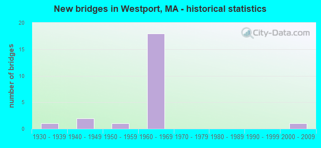
- New bridges - historical statistics
- 11930-1939
- 21940-1949
- 11950-1959
- 181960-1969
- 12000-2009
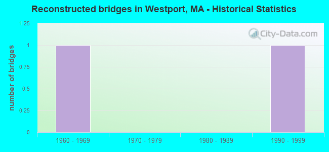
- Reconstructed bridges - Historical Statistics
- 11960-1969
- 01970-1979
- 01980-1989
- 11990-1999
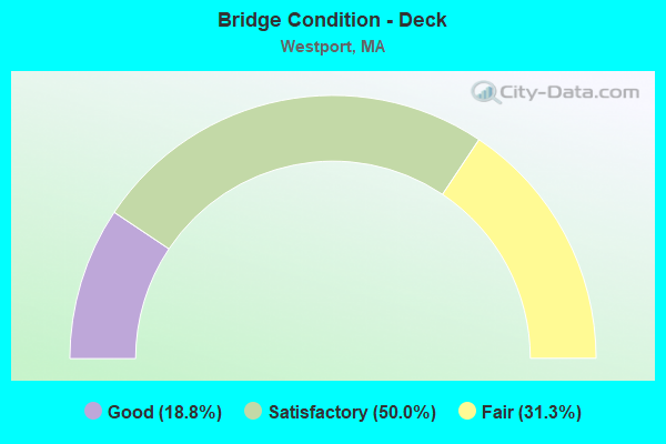
- Bridge Condition - Deck
- 18.8%Good
- 50.0%Satisfactory
- 31.3%Fair
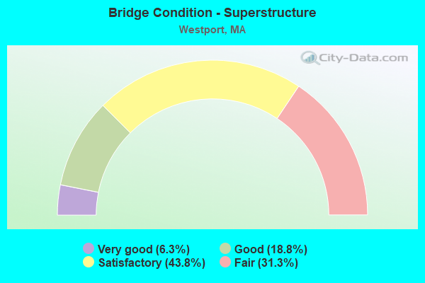
- Bridge Condition - Superstructure
- 6.3%Very good
- 18.8%Good
- 43.8%Satisfactory
- 31.3%Fair
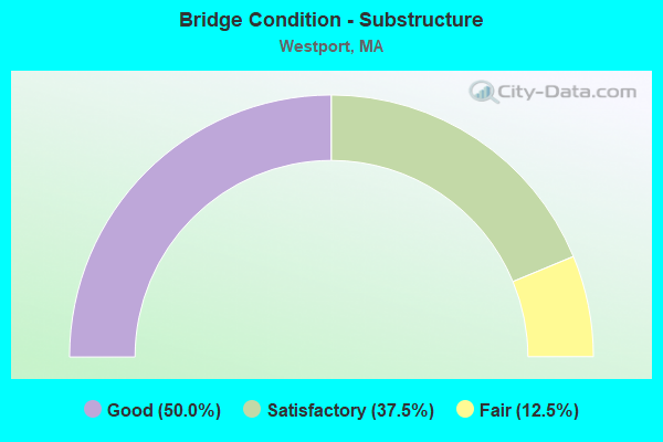
- Bridge Condition - Substructure
- 50.0%Good
- 37.5%Satisfactory
- 12.5%Fair
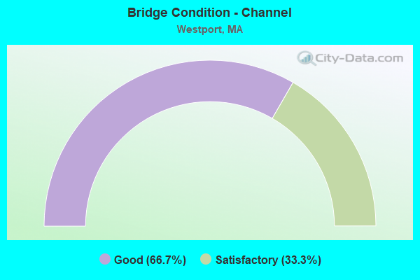
- Bridge Condition - Channel
- 66.7%Good
- 33.3%Satisfactory
Find on map >> Show street view
Structure Number: D040123XCDOTNBI, Location: AT WESTPORT TL (Lat: 41.658406, Lng: -71.057889), Route carried "on" structure: City street , Year Built: 1965, Status: Open, Structure Length: 9.24m (30.31ft), Average Daily Traffic: 1,428 (year 2021), Truck Traffic: 5%, Average Future Daily Traffic: 4,738 (year 2032), Design Load: H 20, Features Intersected: I 195, Facility Carried by Structure: HWY HIGHLAND AVE
Minimum Vertical Clearance: 30+ m (98+ ft), Kilometerpoint: 0.016, Lanes on structure: 2, Lanes under structure: 6, Owner: State Highway Agency, Approaching Roadway Width: 9.8m (32.2ft), Skew: 3 degrees, Material/Design: Steel, Design/Construction: Stringer/Multi-beam, Number Of Spans In Main Unit: 5, Length of Maximum Span: 23.8m (78.1ft), Curb or Sidewalk Widths: Left: 0.5m (1.6ft), Right: 1.5m (4.9ft), Curb-To-Curb Width: 9.8m (32.2ft), Out-to-Out Width: 12.6m (41.3ft)
Condition: Deck: Satisfactory, Superstructure: Fair, Substructure: Satisfactory, Operating Rating: 58.0 metric tons, Method Used To Determine Operating Rating: Load Factor (LF), Inventory Rating: 34.8 metric tons, Method Used To Determine Inventory Rating: Load Factor (LF), Structural Evaluation: Somewhat better than minimum adequacy, Deck Geometry: Somewhat better than minimum adequacy, Underclear: High priority of corrective action, Approach Roadway Alignment: Equal to present desirable criteria, Length Of Structure Improvement: 9.30m (30.51ft), Designated Inspection Frequency: Every 24 months, Inspection Date: September 2021, Bridge Improvement Cost: $4,603,000, Roadway Improvement Cost: $461,000, Total Project Cost: $6,905,000 ( Estimate for 2022), Deck Structure Type: Concrete Cast-file-Place, Wearing Surface/Protective System: Wearing Surface: Bituminous, Membrane: Built-up
Find on map >> Show street view
Structure Number: W30002AQQMUNNBI, Location: .7 MI E OF RTE 88 (Lat: 41.570183, Lng: -71.071714), Route carried "on" structure: City street , Year Built: 2005, Status: Open, Structure Length: 10.70m (35.10ft), Average Daily Traffic: 3,011 (year 2019), Truck Traffic: 8%, Average Future Daily Traffic: 11,845 (year 2031), Design Load: HS 20, Features Intersected: WATER E BR WESTPORT RIV, Facility Carried by Structure: HWY HIXBRIDGE RD
Minimum Vertical Clearance: 30+ m (98+ ft), Kilometerpoint: 0.000, Lanes on structure: 2, Owner: Town or Township Highway Agency, Approaching Roadway Width: 10.5m (34.4ft), Navigation Control: Yes ( Vertical Clearance: 2.2m (7.2ft), Horizontal Clearance: 16.0m (52.5ft)), Material/Design: Prestressed concrete continuous, Design/Construction: Box Beam or Girders - Single/Spread, Number Of Spans In Main Unit: 6, Length of Maximum Span: 17.5m (57.4ft), Curb or Sidewalk Widths: Left: 1.9m (6.2ft), Right: 1.9m (6.2ft), Curb-To-Curb Width: 10.5m (34.4ft), Out-to-Out Width: 15.5m (50.9ft)
Condition: Deck: Good, Superstructure: Very good, Substructure: Satisfactory, Channel: Good, Operating Rating: 77.0 metric tons, Method Used To Determine Operating Rating: Load Factor (LF), Inventory Rating: 76.8 metric tons, Method Used To Determine Inventory Rating: Load Factor (LF), Structural Evaluation: Equal to present minimum criteria, Deck Geometry: Somewhat better than minimum adequacy, Waterway Adequacy: Equal to present minimum criteria, Approach Roadway Alignment: Equal to present desirable criteria, Length Of Structure Improvement: 10.80m (35.43ft), Designated Inspection Frequency: Every 24 months, Underwater Inspection Frequency: Every 48 months, Inspection Date: September 2020, Underwater Inspection Date: September 2018, Bridge Improvement Cost: $2,953,000, Roadway Improvement Cost: $296,000, Total Project Cost: $4,430,000 ( Estimate for 2022), Deck Structure Type: Concrete Cast-file-Place, Wearing Surface/Protective System: Wearing Surface: Bituminous, Membrane: Built-up, Deck Protection: Epoxy Coated Reinforcing
Find on map >> Show street view
Structure Number: W300033KJMUNNBI, Location: .9 MI E OF RTE 88 (Lat: 41.620956, Lng: -71.059758), Route carried "on" structure: City street , Year Built: 1966, Status: Open, Structure Length: 1.31m (4.30ft), Average Daily Traffic: 8,664 (year 2018), Truck Traffic: 3%, Average Future Daily Traffic: 14,056 (year 2031), Design Load: H 20, Features Intersected: WATER E BR WESTPORT RIV, Facility Carried by Structure: HWY OLD CNTY RD
Minimum Vertical Clearance: 30+ m (98+ ft), Kilometerpoint: 1.674, Lanes on structure: 2, Owner: Town or Township Highway Agency, Approaching Roadway Width: 11.0m (36.1ft), Material/Design: Prestressed concrete, Design/Construction: Slab, Number Of Spans In Main Unit: 1, Length of Maximum Span: 12.2m (40.0ft), Curb or Sidewalk Widths: Left: 1.4m (4.6ft), Right: 1.4m (4.6ft), Curb-To-Curb Width: 10.9m (35.8ft), Out-to-Out Width: 14.0m (45.9ft)
Condition: Deck: Satisfactory, Superstructure: Satisfactory, Substructure: Good, Channel: Good, Operating Rating: 55.1 metric tons, Method Used To Determine Operating Rating: Load Factor (LF), Inventory Rating: 44.7 metric tons, Method Used To Determine Inventory Rating: Load Factor (LF), Structural Evaluation: Equal to present minimum criteria, Deck Geometry: Meets minimum limits, Waterway Adequacy: Equal to present minimum criteria, Approach Roadway Alignment: Equal to present desirable criteria, Length Of Structure Improvement: 1.40m (4.59ft), Designated Inspection Frequency: Every 24 months, Inspection Date: November 2020, Bridge Improvement Cost: $330,000, Roadway Improvement Cost: $34,000, Total Project Cost: $496,000 ( Estimate for 2022), Deck Structure Type: Concrete Precast Panels, Wearing Surface/Protective System: Wearing Surface: Bituminous, Membrane: Built-up
Find on map >> Show street view
Structure Number: W300043M3MUNNBI, Location: .3 MI S OF RTE 177 (Lat: 41.631283, Lng: -71.054006), Route carried "on" structure: City street , Year Built: 1938, Year Reconstructed: 1967, Status: Posted for load, Structure Length: 1.34m (4.40ft), Average Daily Traffic: 857 (year 2022), Average Future Daily Traffic: 3,159 (year 2031), Design Load: H 20, Features Intersected: WATER E BR WESTPORT RIV, Facility Carried by Structure: HWY FORGE RD
Minimum Vertical Clearance: 30+ m (98+ ft), Kilometerpoint: 0.000, Lanes on structure: 2, Owner: Town or Township Highway Agency, Approaching Roadway Width: 6.7m (22.0ft), Material/Design: Prestressed concrete, Design/Construction: Slab, Number Of Spans In Main Unit: 1, Length of Maximum Span: 12.2m (40.0ft), Curb or Sidewalk Widths: Left: 1.5m (4.9ft), Right: 0.3m (1.0ft), Curb-To-Curb Width: 6.7m (22.0ft), Out-to-Out Width: 8.5m (27.9ft)
Condition: Deck: Satisfactory, Superstructure: Satisfactory, Substructure: Satisfactory, Channel: Good, Operating Rating: 47.8 metric tons, Method Used To Determine Operating Rating: Allowable Stress (AS), Inventory Rating: 28.6 metric tons, Method Used To Determine Inventory Rating: Allowable Stress (AS), Structural Evaluation: Equal to present minimum criteria, Deck Geometry: Meets minimum limits, Waterway Adequacy: Equal to present minimum criteria, Approach Roadway Alignment: Equal to present minimum criteria, Length Of Structure Improvement: 1.40m (4.59ft), Designated Inspection Frequency: Every 24 months, Underwater Inspection Frequency: Every 36 months, Inspection Date: March 2022, Underwater Inspection Date: March 2020, Bridge Improvement Cost: $468,000, Roadway Improvement Cost: $47,000, Total Project Cost: $703,000 ( Estimate for 2022), Deck Structure Type: Concrete Precast Panels, Wearing Surface/Protective System: Wearing Surface: Bituminous
Find on map >> Show street view
Structure Number: W300123W5DOTNBI, Location: 1.1 MI E OF ST 88 (Lat: 41.634125, Lng: -71.062789), Route carried "on" structure: State highway 177, Year Built: 1941, Status: Open, Structure Length: 0.61m (2.00ft), Average Daily Traffic: 6,178 (year 2019), Truck Traffic: 6%, Average Future Daily Traffic: 18,320 (year 2031), Design Load: H 20, Features Intersected: WATER BREAD CHEESE BROOK
Minimum Vertical Clearance: 30+ m (98+ ft), Kilometerpoint: 6.276, Lanes on structure: 2, Owner: State Highway Agency, Approaching Roadway Width: 12.5m (41.0ft), Material/Design: Concrete, Design/Construction: Culvert, Number Of Spans In Main Unit: 1, Length of Maximum Span: 6.1m (20.0ft)
Condition: Channel: Satisfactory, Culverts: Good, Inventory Rating: 83.7 metric tons, Method Used To Determine Inventory Rating: Load Factor (LF), Structural Evaluation: Better than present minimum criteria, Waterway Adequacy: Equal to present desirable criteria, Approach Roadway Alignment: Equal to present desirable criteria, Length Of Structure Improvement: 0.10m (0.33ft), Designated Inspection Frequency: Every 24 months, Inspection Date: May 2020, Bridge Improvement Cost: $58,000, Roadway Improvement Cost: $6,000, Total Project Cost: $88,000 ( Estimate for 2022)
Find on map >> Show street view
Structure Number: W300143W4DOTNBI, Location: .3 MI SW OF US 6 (Lat: 41.636183, Lng: -71.049450), Route carried "on" structure: State highway 177, Year Built: 1941, Status: Open, Structure Length: 1.83m (6.00ft), Average Daily Traffic: 10,345 (year 2022), Truck Traffic: 5%, Average Future Daily Traffic: 19,741 (year 2033), Design Load: H 20, Features Intersected: WATER E BR WESTPORT RIV
Minimum Vertical Clearance: 30+ m (98+ ft), Kilometerpoint: 6.437, Lanes on structure: 2, Owner: State Highway Agency, Approaching Roadway Width: 7.3m (24.0ft), Material/Design: Steel, Design/Construction: Stringer/Multi-beam, Number Of Spans In Main Unit: 1, Length of Maximum Span: 17.4m (57.1ft), Curb or Sidewalk Widths: Left: 0.2m (0.7ft), Right: 0.2m (0.7ft), Curb-To-Curb Width: 12.2m (40.0ft), Out-to-Out Width: 13.6m (44.6ft)
Condition: Deck: Satisfactory, Superstructure: Good, Substructure: Good, Channel: Good, Operating Rating: 43.5 metric tons, Method Used To Determine Operating Rating: Allowable Stress (AS), Inventory Rating: 23.6 metric tons, Method Used To Determine Inventory Rating: Allowable Stress (AS), Structural Evaluation: Somewhat better than minimum adequacy, Deck Geometry: Somewhat better than minimum adequacy, Waterway Adequacy: Equal to present desirable criteria, Approach Roadway Alignment: Equal to present desirable criteria, Length Of Structure Improvement: 1.90m (6.23ft), Designated Inspection Frequency: Every 24 months, Inspection Date: March 2022, Bridge Improvement Cost: $1,015,000, Roadway Improvement Cost: $102,000, Total Project Cost: $1,523,000 ( Estimate for 2022), Deck Structure Type: Concrete Cast-file-Place, Wearing Surface/Protective System: Wearing Surface: Bituminous, Membrane: Built-up
Find on map >> Show street view
Structure Number: W300163W6DOTNBI, Location: .8 MI S OF DRIFT RD. (Lat: 41.517253, Lng: -71.067950), Route carried "on" structure: State highway 88, Year Built: 1958, Year Reconstructed: 2004, Status: Open, Structure Length: 31.24m (102.49ft), Average Daily Traffic: 6,500 (year 2018), Truck Traffic: 2%, Average Future Daily Traffic: 11,845 (year 2031), Design Load: HS 20, Features Intersected: WATER WESTPORT RIVER
Minimum Vertical Clearance: 30+ m (98+ ft), Kilometerpoint: 0.000, Lanes on structure: 4, Owner: State Highway Agency, Approaching Roadway Width: 21.9m (71.9ft), Skew: 20 degrees, Navigation Control: Yes ( Vertical Clearance: 6.1m (20.0ft), Horizontal Clearance: 15.2m (49.9ft)), Material/Design: Steel, Design/Construction: Movable - Bascule, Number Of Spans In Main Unit: 1, Number Of Approach Spans: 13, Length of Maximum Span: 22.9m (75.1ft), Curb or Sidewalk Widths: Left: 1.5m (4.9ft), Right: 1.5m (4.9ft), Curb-To-Curb Width: 18.3m (60.0ft), Out-to-Out Width: 21.9m (71.9ft)
Condition: Deck: Satisfactory, Superstructure: Fair, Substructure: Fair, Channel: Satisfactory, Operating Rating: 31.7 metric tons, Method Used To Determine Operating Rating: Load Factor (LF), Inventory Rating: 19.0 metric tons, Method Used To Determine Inventory Rating: Load Factor (LF), Structural Evaluation: Meets minimum limits, Deck Geometry: Somewhat better than minimum adequacy, Waterway Adequacy: Equal to present desirable criteria, Approach Roadway Alignment: Equal to present desirable criteria, Bridge Posting: Required (Relationship of Operating Rating to Maximum Legal Load: 0.1 - 9.9% below), Length Of Structure Improvement: 31.30m (102.69ft), Designated Inspection Frequency: Every 24 months, Critical Feature Inspection Frequency: Every 24 months, Underwater Inspection Frequency: Every 36 months, Inspection Date: October 2020, Critical Feature Inspection Date: October 2020, Underwater Inspection Date: June 2020, Bridge Improvement Cost: $26,926,000, Roadway Improvement Cost: $2,693,000, Total Project Cost: $40,390,000 ( Estimate for 2022), Deck Structure Type: Concrete Cast-file-Place, Wearing Surface/Protective System: Wearing Surface: Bituminous, Membrane: Built-up
Find on map >> Show street view
Structure Number: W300233W7DOTNBI, Location: 1.5 MI. S. OF US 6 (Lat: 41.633131, Lng: -71.078811), Route carried "on" structure: State highway 88, Year Built: 1961, Status: Open, Structure Length: 3.81m (12.50ft), Average Daily Traffic: 9,083 (year 2019), Truck Traffic: 3%, Average Future Daily Traffic: 18,162 (year 2032), Design Load: H 20, Features Intersected: ST177 AMERICAN LGN HWY
Minimum Vertical Clearance: 30+ m (98+ ft), Kilometerpoint: 13.856, Lanes on structure: 2, Lanes under structure: 2, Owner: State Highway Agency, Approaching Roadway Width: 13.4m (44.0ft), Skew: 30 degrees, Material/Design: Prestressed concrete, Design/Construction: Stringer/Multi-beam, Number Of Spans In Main Unit: 3, Length of Maximum Span: 18.0m (59.1ft), Curb or Sidewalk Widths: Left: 0.5m (1.6ft), Right: 0.5m (1.6ft), Curb-To-Curb Width: 13.4m (44.0ft), Out-to-Out Width: 15.3m (50.2ft)
Condition: Deck: Satisfactory, Superstructure: Fair, Substructure: Good, Operating Rating: 37.8 metric tons, Method Used To Determine Operating Rating: Allowable Stress (AS), Inventory Rating: 26.1 metric tons, Method Used To Determine Inventory Rating: Allowable Stress (AS), Structural Evaluation: Somewhat better than minimum adequacy, Deck Geometry: Equal to present minimum criteria, Underclear: Meets minimum limits, Approach Roadway Alignment: Equal to present desirable criteria, Length Of Structure Improvement: 3.90m (12.80ft), Designated Inspection Frequency: Every 24 months, Inspection Date: September 2021, Bridge Improvement Cost: $2,344,000, Roadway Improvement Cost: $235,000, Total Project Cost: $3,517,000 ( Estimate for 2022), Deck Structure Type: Concrete Cast-file-Place, Wearing Surface/Protective System: Wearing Surface: Bituminous, Membrane: Built-up
Find on map >> Show street view
Structure Number: W300253UDDOTNBI, Location: .6 MI E OF FALL RIVER C.L (Lat: 41.679678, Lng: -71.107544), Route carried "on" structure: Interstate 195, Year Built: 1964, Status: Open, Structure Length: 3.81m (12.50ft), Average Daily Traffic: 34,181 (year 2017), Truck Traffic: 5%, Average Future Daily Traffic: 48,958 (year 2031), Design Load: HS 20, Features Intersected: HWY SANFORD RD
Minimum Vertical Clearance: 30+ m (98+ ft), Kilometerpoint: 24.701, Lanes on structure: 3, Lanes under structure: 2, Base Highway Network: Yes, Owner: State Highway Agency, Approaching Roadway Width: 16.1m (52.8ft), Skew: 1 degrees, Material/Design: Prestressed concrete, Design/Construction: Stringer/Multi-beam, Number Of Spans In Main Unit: 3, Length of Maximum Span: 17.1m (56.1ft), Curb-To-Curb Width: 16.1m (52.8ft), Out-to-Out Width: 17.1m (56.1ft)
Condition: Deck: Fair, Superstructure: Satisfactory, Substructure: Satisfactory, Operating Rating: 53.2 metric tons, Method Used To Determine Operating Rating: Load Factor (LF), Inventory Rating: 31.9 metric tons, Method Used To Determine Inventory Rating: Load Factor (LF), Structural Evaluation: Equal to present minimum criteria, Deck Geometry: Equal to present minimum criteria, Underclear: Meets minimum limits, Approach Roadway Alignment: Equal to present desirable criteria, Length Of Structure Improvement: 3.90m (12.80ft), Designated Inspection Frequency: Every 24 months, Inspection Date: December 2020, Bridge Improvement Cost: $2,620,000, Roadway Improvement Cost: $263,000, Total Project Cost: $3,931,000 ( Estimate for 2022), Deck Structure Type: Concrete Cast-file-Place, Wearing Surface/Protective System: Wearing Surface: Monolithic Concrete, Deck Protection: Epoxy Coated Reinforcing
Find on map >> Show street view
Structure Number: W300253UEDOTNBI, Location: .6 MI E OF FALL RIVER C.L (Lat: 41.680019, Lng: -71.107253), Route carried "on" structure: Interstate 195, Year Built: 1964, Status: Open, Structure Length: 3.81m (12.50ft), Average Daily Traffic: 29,874 (year 2019), Truck Traffic: 2%, Average Future Daily Traffic: 48,958 (year 2031), Design Load: HS 20, Features Intersected: HWY SANFORD RD
Minimum Vertical Clearance: 30+ m (98+ ft), Kilometerpoint: 24.701, Lanes on structure: 3, Lanes under structure: 2, Base Highway Network: Yes, Owner: State Highway Agency, Approaching Roadway Width: 16.1m (52.8ft), Skew: 1 degrees, Material/Design: Prestressed concrete, Design/Construction: Stringer/Multi-beam, Number Of Spans In Main Unit: 3, Length of Maximum Span: 17.1m (56.1ft), Curb-To-Curb Width: 16.1m (52.8ft), Out-to-Out Width: 17.1m (56.1ft)
Condition: Deck: Satisfactory, Superstructure: Satisfactory, Substructure: Good, Operating Rating: 53.2 metric tons, Method Used To Determine Operating Rating: Load Factor (LF), Inventory Rating: 39.1 metric tons, Method Used To Determine Inventory Rating: Load Factor (LF), Structural Evaluation: Equal to present minimum criteria, Deck Geometry: Equal to present minimum criteria, Underclear: Meets minimum limits, Approach Roadway Alignment: Equal to present desirable criteria, Length Of Structure Improvement: 3.90m (12.80ft), Designated Inspection Frequency: Every 24 months, Inspection Date: December 2020, Bridge Improvement Cost: $846,000, Roadway Improvement Cost: $85,000, Total Project Cost: $1,270,000 ( Estimate for 2022), Deck Structure Type: Concrete Cast-file-Place, Wearing Surface/Protective System: Wearing Surface: Monolithic Concrete, Deck Protection: Other
Find on map >> Show street view
Structure Number: W300263WBDOTNBI, Location: .6 MI N OF US 6 (Lat: 41.673467, Lng: -71.090408), Route carried "on" structure: Ramp State highway 88, Year Built: 1964, Status: Open, Structure Length: 7.62m (25.00ft), Average Daily Traffic: 8,293 (year 2018), Truck Traffic: 6%, Average Future Daily Traffic: 19,741 (year 2032), Design Load: H 20, Features Intersected: I 195
Minimum Vertical Clearance: 30+ m (98+ ft), Kilometerpoint: 0.000, Lanes on structure: 2, Lanes under structure: 7, Owner: State Highway Agency, Approaching Roadway Width: 8.5m (27.9ft), Material/Design: Steel, Design/Construction: Stringer/Multi-beam, Number Of Spans In Main Unit: 5, Length of Maximum Span: 19.8m (65.0ft), Curb or Sidewalk Widths: Left: 0.5m (1.6ft), Right: 0.5m (1.6ft), Curb-To-Curb Width: 8.5m (27.9ft), Out-to-Out Width: 10.4m (34.1ft)
Condition: Deck: Satisfactory, Superstructure: Fair, Substructure: Fair, Operating Rating: 53.8 metric tons, Method Used To Determine Operating Rating: Load Factor (LF), Inventory Rating: 32.2 metric tons, Method Used To Determine Inventory Rating: Load Factor (LF), Structural Evaluation: Somewhat better than minimum adequacy, Deck Geometry: High priority of corrective action, Underclear: High priority of corrective action, Approach Roadway Alignment: Equal to present desirable criteria, Length Of Structure Improvement: 7.70m (25.26ft), Designated Inspection Frequency: Every 24 months, Inspection Date: Febuary 2021, Bridge Improvement Cost: $3,146,000, Roadway Improvement Cost: $315,000, Total Project Cost: $4,720,000 ( Estimate for 2022), Deck Structure Type: Concrete Cast-file-Place, Wearing Surface/Protective System: Wearing Surface: Bituminous, Membrane: Built-up
Find on map >> Show street view
Structure Number: W300283UADOTNBI, Location: .7 MI W OF DARTMOUTH T.L. (Lat: 41.662133, Lng: -71.069319), Route carried "on" structure: Interstate 195, Year Built: 1965, Status: Open, Structure Length: 1.98m (6.50ft), Average Daily Traffic: 37,379 (year 2019), Truck Traffic: 3%, Average Future Daily Traffic: 47,853 (year 2031), Design Load: HS 20, Features Intersected: RR MACRR
Minimum Vertical Clearance: 30+ m (98+ ft), Kilometerpoint: 28.485, Lanes on structure: 3, Base Highway Network: Yes, Owner: State Highway Agency, Approaching Roadway Width: 15.2m (49.9ft), Skew: 5 degrees, Material/Design: Steel, Design/Construction: Stringer/Multi-beam, Number Of Spans In Main Unit: 1, Length of Maximum Span: 18.9m (62.0ft), Curb or Sidewalk Widths: Left: 0.5m (1.6ft), Right: 0.5m (1.6ft), Curb-To-Curb Width: 15.2m (49.9ft), Out-to-Out Width: 17.1m (56.1ft)
Condition: Deck: Good, Superstructure: Satisfactory, Substructure: Good, Operating Rating: 57.9 metric tons, Method Used To Determine Operating Rating: Load Factor (LF), Inventory Rating: 34.7 metric tons, Method Used To Determine Inventory Rating: Load Factor (LF), Structural Evaluation: Equal to present minimum criteria, Deck Geometry: Meets minimum limits, Underclear: High priority of corrective action, Approach Roadway Alignment: Equal to present desirable criteria, Length Of Structure Improvement: 2.00m (6.56ft), Designated Inspection Frequency: Every 24 months, Inspection Date: December 2020, Bridge Improvement Cost: $604,000, Roadway Improvement Cost: $61,000, Total Project Cost: $907,000 ( Estimate for 2022), Deck Structure Type: Concrete Cast-file-Place, Wearing Surface/Protective System: Wearing Surface: Bituminous, Membrane: Built-up
Find on map >> Show street view
Structure Number: W300283UBDOTNBI, Location: .7 MI W OF DARTMOUTH T.L. (Lat: 41.662106, Lng: -71.068594), Route carried "on" structure: Interstate 195, Year Built: 1965, Status: Open, Structure Length: 1.98m (6.50ft), Average Daily Traffic: 38,304 (year 2019), Truck Traffic: 3%, Average Future Daily Traffic: 47,853 (year 2031), Design Load: HS 20, Features Intersected: RR MACRR
Minimum Vertical Clearance: 30+ m (98+ ft), Kilometerpoint: 28.485, Lanes on structure: 3, Base Highway Network: Yes, Owner: State Highway Agency, Approaching Roadway Width: 15.2m (49.9ft), Skew: 5 degrees, Material/Design: Steel, Design/Construction: Stringer/Multi-beam, Number Of Spans In Main Unit: 1, Length of Maximum Span: 18.9m (62.0ft), Curb or Sidewalk Widths: Left: 0.5m (1.6ft), Right: 0.5m (1.6ft), Curb-To-Curb Width: 15.2m (49.9ft), Out-to-Out Width: 17.1m (56.1ft)
Condition: Deck: Good, Superstructure: Good, Substructure: Good, Operating Rating: 57.5 metric tons, Method Used To Determine Operating Rating: Load Factor (LF), Inventory Rating: 34.4 metric tons, Method Used To Determine Inventory Rating: Load Factor (LF), Structural Evaluation: Better than present minimum criteria, Deck Geometry: Meets minimum limits, Underclear: High priority of corrective action, Approach Roadway Alignment: Equal to present desirable criteria, Length Of Structure Improvement: 2.00m (6.56ft), Designated Inspection Frequency: Every 24 months, Inspection Date: December 2020, Bridge Improvement Cost: $604,000, Roadway Improvement Cost: $61,000, Total Project Cost: $907,000 ( Estimate for 2022), Deck Structure Type: Concrete Cast-file-Place, Wearing Surface/Protective System: Wearing Surface: Bituminous, Membrane: Built-up
Find on map >> Show street view
Structure Number: W300303WADOTNBI, Location: .4 MI S OF I 195 (Lat: 41.668083, Lng: -71.092828), Route carried "on" structure: State highway 88, Year Built: 1964, Status: Open, Structure Length: 1.41m (4.63ft), Average Daily Traffic: 22,743 (year 2019), Truck Traffic: 4%, Average Future Daily Traffic: 41,062 (year 2032), Design Load: H 20, Features Intersected: RR MACRR
Minimum Vertical Clearance: 30+ m (98+ ft), Kilometerpoint: 0.000, Lanes on structure: 6, Owner: State Highway Agency, Approaching Roadway Width: 36.5m (119.8ft), Skew: 12 degrees, Material/Design: Steel, Design/Construction: Stringer/Multi-beam, Number Of Spans In Main Unit: 1, Length of Maximum Span: 12.8m (42.0ft), Curb or Sidewalk Widths: Left: 0.5m (1.6ft), Right: 0.5m (1.6ft), Curb-To-Curb Width: 30.5m (100.1ft), Out-to-Out Width: 36.1m (118.4ft)
Condition: Deck: Fair, Superstructure: Good, Substructure: Good, Operating Rating: 49.4 metric tons, Method Used To Determine Operating Rating: Load Factor (LF), Inventory Rating: 29.6 metric tons, Method Used To Determine Inventory Rating: Load Factor (LF), Structural Evaluation: Better than present minimum criteria, Deck Geometry: Superior to present desirable criteria, Underclear: High priority of corrective action, Approach Roadway Alignment: Equal to present desirable criteria, Length Of Structure Improvement: 1.50m (4.92ft), Designated Inspection Frequency: Every 24 months, Inspection Date: December 2020, Bridge Improvement Cost: $2,128,000, Roadway Improvement Cost: $213,000, Total Project Cost: $3,193,000 ( Estimate for 2022), Deck Structure Type: Concrete Cast-file-Place, Wearing Surface/Protective System: Wearing Surface: Other, Membrane: Other
Find on map >> Show street view
Structure Number: W300313W8DOTNBI, Location: .5 MI S OF I 195 (Lat: 41.666158, Lng: -71.093111), Route carried "on" structure: State highway 88, Year Built: 1964, Status: Open, Structure Length: 6.58m (21.59ft), Average Daily Traffic: 7,299 (year 2021), Truck Traffic: 11%, Average Future Daily Traffic: 29,375 (year 2032), Design Load: HS 20, Features Intersected: US 6 STATE RD
Minimum Vertical Clearance: 30+ m (98+ ft), Kilometerpoint: 20.760, Lanes on structure: 3, Lanes under structure: 6, Owner: State Highway Agency, Approaching Roadway Width: 12.2m (40.0ft), Material/Design: Steel, Design/Construction: Stringer/Multi-beam, Number Of Spans In Main Unit: 4, Length of Maximum Span: 18.9m (62.0ft), Curb or Sidewalk Widths: Left: 0.5m (1.6ft), Right: 0.5m (1.6ft), Curb-To-Curb Width: 12.2m (40.0ft), Out-to-Out Width: 14.1m (46.3ft)
Condition: Deck: Fair, Superstructure: Satisfactory, Substructure: Good, Operating Rating: 48.3 metric tons, Method Used To Determine Operating Rating: Load Factor (LF), Inventory Rating: 28.8 metric tons, Method Used To Determine Inventory Rating: Load Factor (LF), Structural Evaluation: Equal to present minimum criteria, Deck Geometry: Meets minimum limits, Underclear: Meets minimum limits, Approach Roadway Alignment: Equal to present desirable criteria, Length Of Structure Improvement: 6.60m (21.65ft), Designated Inspection Frequency: Every 24 months, Inspection Date: December 2021, Bridge Improvement Cost: $3,656,000, Roadway Improvement Cost: $366,000, Total Project Cost: $5,485,000 ( Estimate for 2022), Deck Structure Type: Concrete Cast-file-Place, Wearing Surface/Protective System: Wearing Surface: Monolithic Concrete
Find on map >> Show street view
Structure Number: W300313W9DOTNBI, Location: .5 MI S OF I 195 (Lat: 41.666356, Lng: -71.093444), Route carried "on" structure: State highway 88, Year Built: 1964, Status: Open, Structure Length: 6.58m (21.59ft), Average Daily Traffic: 11,133 (year 2018), Truck Traffic: 10%, Average Future Daily Traffic: 25,269 (year 2032), Design Load: HS 20, Features Intersected: US 6 STATE RD
Minimum Vertical Clearance: 30+ m (98+ ft), Kilometerpoint: 28.739, Lanes on structure: 3, Lanes under structure: 6, Owner: State Highway Agency, Approaching Roadway Width: 12.2m (40.0ft), Skew: 2 degrees, Material/Design: Steel, Design/Construction: Stringer/Multi-beam, Number Of Spans In Main Unit: 4, Length of Maximum Span: 18.9m (62.0ft), Curb or Sidewalk Widths: Left: 0.5m (1.6ft), Right: 0.5m (1.6ft), Curb-To-Curb Width: 12.2m (40.0ft), Out-to-Out Width: 14.1m (46.3ft)
Condition: Deck: Fair, Superstructure: Satisfactory, Substructure: Satisfactory, Operating Rating: 48.3 metric tons, Method Used To Determine Operating Rating: Load Factor (LF), Inventory Rating: 28.8 metric tons, Method Used To Determine Inventory Rating: Load Factor (LF), Structural Evaluation: Equal to present minimum criteria, Deck Geometry: Meets minimum limits, Underclear: Meets minimum limits, Approach Roadway Alignment: Equal to present desirable criteria, Length Of Structure Improvement: 6.60m (21.65ft), Designated Inspection Frequency: Every 24 months, Inspection Date: December 2021, Bridge Improvement Cost: $3,656,000, Roadway Improvement Cost: $366,000, Total Project Cost: $5,485,000 ( Estimate for 2022), Deck Structure Type: Concrete Cast-file-Place, Wearing Surface/Protective System: Wearing Surface: Monolithic Concrete
Find on map >> Show street view
Structure Number: W300323UCDOTNBI, Location: 195 WB RAMP TO 88SB (Lat: 41.674958, Lng: -71.094686), Route carried "on" structure: Ramp Interstate 195, Year Built: 1964, Status: Open, Structure Length: 7.96m (26.12ft), Average Daily Traffic: 5,392 (year 2019), Truck Traffic: 6%, Average Future Daily Traffic: 6,001 (year 2032), Design Load: H 20, Features Intersected: I 195
Minimum Vertical Clearance: 30+ m (98+ ft), Kilometerpoint: 0.000, Lanes on structure: 1, Lanes under structure: 6, Base Highway Network: Yes, Owner: State Highway Agency, Approaching Roadway Width: 6.7m (22.0ft), Skew: 9 degrees, Material/Design: Steel, Design/Construction: Stringer/Multi-beam, Number Of Spans In Main Unit: 5, Length of Maximum Span: 23.2m (76.1ft), Curb or Sidewalk Widths: Left: 0.5m (1.6ft), Right: 0.5m (1.6ft), Curb-To-Curb Width: 6.7m (22.0ft), Out-to-Out Width: 8.6m (28.2ft)
Condition: Deck: Fair, Superstructure: Fair, Substructure: Satisfactory, Operating Rating: 54.9 metric tons, Method Used To Determine Operating Rating: Load Factor (LF), Inventory Rating: 32.9 metric tons, Method Used To Determine Inventory Rating: Load Factor (LF), Structural Evaluation: Somewhat better than minimum adequacy, Deck Geometry: Equal to present minimum criteria, Underclear: High priority of corrective action, Approach Roadway Alignment: Equal to present desirable criteria, Length Of Structure Improvement: 8.00m (26.25ft), Designated Inspection Frequency: Every 24 months, Inspection Date: Febuary 2021, Bridge Improvement Cost: $2,703,000, Roadway Improvement Cost: $271,000, Total Project Cost: $4,055,000 ( Estimate for 2022), Deck Structure Type: Concrete Cast-file-Place, Wearing Surface/Protective System: Wearing Surface: Monolithic Concrete
Find on map >> Show street view
Structure Number: D040123XCDOTNBI, Location: AT DARTMOUTH T.L. (Lat: 41.666667, Lng: -71.083333), Route carried "under" structure: Interstate 195, Year Built: 1965, Structure Length: 0. m, Average Daily Traffic: 33,369 (year 0000), Features Intersected: I 195 EB, Facility Carried by Structure: HWY DAVIS RD.
Minimum Vertical Clearance: 4.47m (14.67ft), Kilometerpoint: 0.000, Lanes on structure: 4, Lanes under structure: 2, Material/Design: Steel, Design/Construction: Stringer/Multi-beam, Length of Maximum Span: 23.8m (78.1ft)
Find on map >> Show street view
Structure Number: D040123XCDOTNBI, Location: 083089 STATUTORY (Lat: 41.666667, Lng: -71.083333), Route carried "under" structure: Interstate 195, Year Built: 1965, Structure Length: 0. m, Average Daily Traffic: 33,369 (year 0000), Features Intersected: I 195 WB, Facility Carried by Structure: HWY DAVIS RD.
Minimum Vertical Clearance: 4.47m (14.67ft), Kilometerpoint: 0.000, Lanes on structure: 4, Lanes under structure: 2, Material/Design: Steel, Design/Construction: Stringer/Multi-beam, Length of Maximum Span: 23.8m (78.1ft)
Find on map >> Show street view
Structure Number: W300263WBDOTNBI, Location: .6 MI N OF US 6 (Lat: 41.666667, Lng: -71.083333), Route carried "under" structure: Interstate 195, Year Built: 1964, Structure Length: 0. m, Average Daily Traffic: 10,609 (year 0000), Features Intersected: I 195 EB, Facility Carried by Structure: ST 88 RAMP
Minimum Vertical Clearance: 4.62m (15.16ft), Kilometerpoint: 0.000, Lanes on structure: 4, Lanes under structure: 2, Material/Design: Steel, Design/Construction: Stringer/Multi-beam, Length of Maximum Span: 19.8m (65.0ft)
Find on map >> Show street view
Structure Number: W300263WBDOTNBI, Location: .6 MI N OF US 6 (Lat: 41.683333, Lng: -71.083333), Route carried "under" structure: Interstate 195, Year Built: 1964, Structure Length: 0. m, Average Daily Traffic: 10,609 (year 0000), Features Intersected: I 195 WB, Facility Carried by Structure: ST 88 RAMP
Minimum Vertical Clearance: 4.62m (15.16ft), Kilometerpoint: 0.000, Lanes on structure: 4, Lanes under structure: 2, Material/Design: Steel, Design/Construction: Stringer/Multi-beam, Length of Maximum Span: 19.8m (65.0ft)
Find on map >> Show street view
Structure Number: W300323UCDOTNBI, Location: 1.4 MI E OF FALL RIV C.L. (Lat: 41.666667, Lng: -71.100000), Route carried "under" structure: Interstate 195, Year Built: 1964, Structure Length: 0. m, Average Daily Traffic: 7,284 (year 0000), Features Intersected: I 195 EB
Minimum Vertical Clearance: 4.42m (14.50ft), Kilometerpoint: 0.000, Lanes on structure: 4, Lanes under structure: 2, Material/Design: Steel, Design/Construction: Stringer/Multi-beam, Length of Maximum Span: 23.2m (76.1ft)
Find on map >> Show street view
Structure Number: W300323UCDOTNBI, Location: 1.4 MI E OF FALL RIV C.L. (Lat: 41.666667, Lng: -71.100000), Route carried "under" structure: Interstate 195, Year Built: 1964, Structure Length: 0. m, Average Daily Traffic: 7,284 (year 0000), Features Intersected: I 195 WB
Minimum Vertical Clearance: 4.42m (14.50ft), Kilometerpoint: 0.000, Lanes on structure: 4, Lanes under structure: 2, Material/Design: Steel, Design/Construction: Stringer/Multi-beam, Length of Maximum Span: 23.2m (76.1ft)