Bridge Statistics for White Pine, Tennessee (TN)
Condition, Traffic, Stress, Structural Evaluation, Project Costs
- National Bridge Inventory (NBI) Statistics
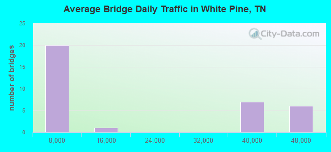
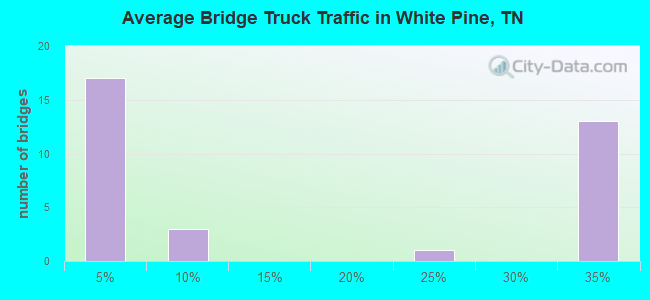
- 34Number of bridges
- 299ft / 91.2mTotal length
- $11,452,000Total costs
- 568,869Total average daily traffic
- 165,556Total average daily truck traffic
- National Bridge Inventory (NBI) Registered Bridges for White Pine
- No street view available for this location

- New bridges - historical statistics
- 21910-1919
- 21930-1939
- 21950-1959
- 151960-1969
- 11970-1979
- 31980-1989
- 41990-1999
- 52000-2009
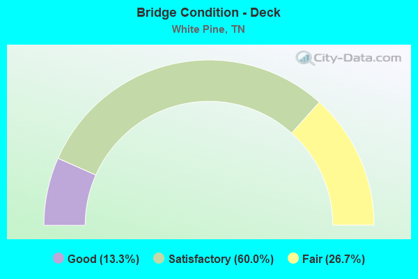
- Bridge Condition - Deck
- 13.3%Good
- 60.0%Satisfactory
- 26.7%Fair
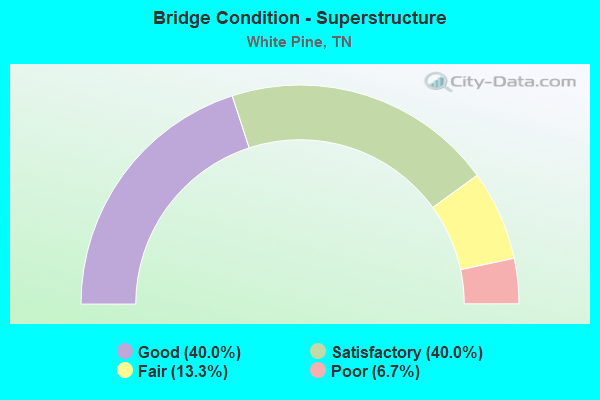
- Bridge Condition - Superstructure
- 40.0%Good
- 40.0%Satisfactory
- 13.3%Fair
- 6.7%Poor
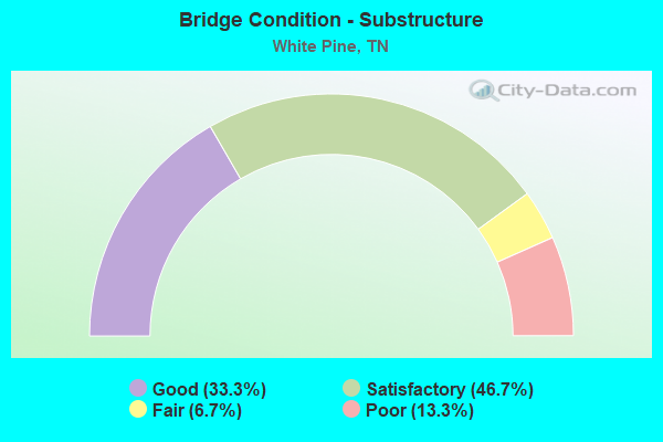
- Bridge Condition - Substructure
- 33.3%Good
- 46.7%Satisfactory
- 6.7%Fair
- 13.3%Poor
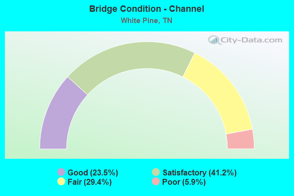
- Bridge Condition - Channel
- 23.5%Good
- 41.2%Satisfactory
- 29.4%Fair
- 5.9%Poor
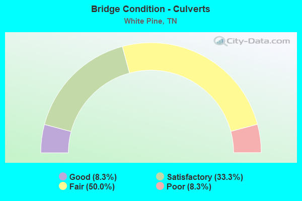
- Bridge Condition - Culverts
- 8.3%Good
- 33.3%Satisfactory
- 50.0%Fair
- 8.3%Poor
Find on map >> Show street view
Structure Number: 150A1030001, Location: 4 M W OF SR 160-AT CO LN (Lat: 36.122033, Lng: -83.237250), Route carried "on" structure: County highway 103, Year Built: 1938, Status: Open, Structure Length: 0.88m (2.89ft), Average Daily Traffic: 40 (year 2022), Truck Traffic: 2%, Average Future Daily Traffic: 64 (year 2040), Design Load: HS 20, Features Intersected: KNEELAS CREEK
Minimum Vertical Clearance: 30+ m (98+ ft), Kilometerpoint: 2.688, Lanes on structure: 1, Owner: County Highway Agency, Approaching Roadway Width: 4.0m (13.1ft), Skew: 3 degrees, Material/Design: Concrete continuous, Design/Construction: Culvert, Number Of Spans In Main Unit: 2, Length of Maximum Span: 4.3m (14.1ft)
Condition: Channel: Satisfactory, Culverts: Good, Operating Rating: 54.0 metric tons, Method Used To Determine Operating Rating: Field evaluation and documented engineering judgment, Inventory Rating: 32.4 metric tons, Method Used To Determine Inventory Rating: Field evaluation and documented engineering judgment, Structural Evaluation: Better than present minimum criteria, Waterway Adequacy: Better than present minimum criteria, Approach Roadway Alignment: Equal to present minimum criteria, Designated Inspection Frequency: Every 24 months, Inspection Date: October 2020
Find on map >> Show street view
Structure Number: 32I00810001, Location: .2/M.FROM JEFFERSON CO.LN (Lat: 36.136183, Lng: -83.282900), Route carried "on" structure: Interstate 81, Year Built: 1967, Status: Open, Structure Length: 3.71m (12.17ft), Average Daily Traffic: 39,764 (year 2020), Truck Traffic: 32%, Average Future Daily Traffic: 57,600 (year 2040), Design Load: HS 20, Features Intersected: SOUTHERN RAILWAY
Minimum Vertical Clearance: 30+ m (98+ ft), Kilometerpoint: 0.370, Lanes on structure: 2, Base Highway Network: Yes, Owner: State Highway Agency, Approaching Roadway Width: 11.6m (38.1ft), Skew: 12 degrees, Material/Design: Prestressed concrete continuous, Design/Construction: Stringer/Multi-beam, Number Of Spans In Main Unit: 3, Length of Maximum Span: 12.4m (40.7ft), Curb-To-Curb Width: 11.1m (36.4ft), Out-to-Out Width: 12.3m (40.4ft)
Condition: Deck: Fair, Superstructure: Good, Substructure: Satisfactory, Operating Rating: 47.0 metric tons, Method Used To Determine Operating Rating: Load Factor (LF), Inventory Rating: 19.8 metric tons, Method Used To Determine Inventory Rating: Load Factor (LF), Structural Evaluation: Somewhat better than minimum adequacy, Deck Geometry: Somewhat better than minimum adequacy, Underclear: Equal to present minimum criteria, Approach Roadway Alignment: Equal to present desirable criteria, Length Of Structure Improvement: 3.71m (12.17ft), Designated Inspection Frequency: Every 24 months, Inspection Date: Febuary 2022, Bridge Improvement Cost: $797,000, Roadway Improvement Cost: $80,000, Total Project Cost: $1,196,000 ( Estimate for 2020), Deck Structure Type: Concrete Precast Panels, Wearing Surface/Protective System: Wearing Surface: Bituminous
Find on map >> Show street view
Structure Number: 32I00810002, Location: .2 M.FROM JEFFERSON CO.LN (Lat: 36.136017, Lng: -83.283000), Route carried "on" structure: Interstate 81, Year Built: 1967, Status: Open, Structure Length: 3.71m (12.17ft), Average Daily Traffic: 39,764 (year 2020), Truck Traffic: 32%, Average Future Daily Traffic: 62,800 (year 2040), Design Load: HS 20, Features Intersected: SOUTHERN RAILWAY
Minimum Vertical Clearance: 30+ m (98+ ft), Kilometerpoint: 0.370, Lanes on structure: 2, Base Highway Network: Yes, Owner: State Highway Agency, Approaching Roadway Width: 11.6m (38.1ft), Skew: 12 degrees, Material/Design: Prestressed concrete continuous, Design/Construction: Stringer/Multi-beam, Number Of Spans In Main Unit: 3, Length of Maximum Span: 12.4m (40.7ft), Curb-To-Curb Width: 11.1m (36.4ft), Out-to-Out Width: 12.4m (40.7ft)
Condition: Deck: Satisfactory, Superstructure: Good, Substructure: Satisfactory, Operating Rating: 52.2 metric tons, Method Used To Determine Operating Rating: Load Factor (LF), Inventory Rating: 31.5 metric tons, Method Used To Determine Inventory Rating: Load Factor (LF), Structural Evaluation: Equal to present minimum criteria, Deck Geometry: Somewhat better than minimum adequacy, Underclear: Equal to present minimum criteria, Approach Roadway Alignment: Equal to present desirable criteria, Designated Inspection Frequency: Every 24 months, Inspection Date: Febuary 2022, Deck Structure Type: Concrete Precast Panels, Wearing Surface/Protective System: Wearing Surface: Bituminous
Find on map >> Show street view
Structure Number: 32I00810039, Location: JEFFERSON CO LINE (Lat: 36.136183, Lng: -83.281467), Route carried "on" structure: Interstate 81, Year Built: 1964, Status: Open, Structure Length: 0.63m (2.07ft), Average Daily Traffic: 39,764 (year 2020), Truck Traffic: 32%, Average Future Daily Traffic: 62,800 (year 2040), Design Load: HS 20, Features Intersected: SINKING FORK CREEK
Minimum Vertical Clearance: 30+ m (98+ ft), Kilometerpoint: 0.499, Lanes on structure: 4, Base Highway Network: Yes, Owner: State Highway Agency, Approaching Roadway Width: 23.2m (76.1ft), Material/Design: Concrete continuous, Design/Construction: Culvert, Number Of Spans In Main Unit: 2, Length of Maximum Span: 3.0m (9.8ft)
Condition: Channel: Good, Culverts: Satisfactory, Operating Rating: 54.0 metric tons, Method Used To Determine Operating Rating: Field evaluation and documented engineering judgment, Inventory Rating: 32.4 metric tons, Method Used To Determine Inventory Rating: Field evaluation and documented engineering judgment, Structural Evaluation: Equal to present minimum criteria, Waterway Adequacy: Equal to present desirable criteria, Approach Roadway Alignment: Equal to present desirable criteria, Length Of Structure Improvement: 0.63m (2.07ft), Designated Inspection Frequency: Every 24 months, Inspection Date: Febuary 2022, Bridge Improvement Cost: $207,000, Roadway Improvement Cost: $21,000, Total Project Cost: $311,000 ( Estimate for 2020)
Find on map >> Show street view
Structure Number: 45024570001, Location: W OF US25E AT WHITE PINE (Lat: 36.112633, Lng: -83.296867), Route carried "on" structure: County highway 2457, Year Built: 1938, Year Reconstructed: 2016, Status: Open, Structure Length: 2.06m (6.76ft), Average Daily Traffic: 729 (year 2020), Truck Traffic: 4%, Average Future Daily Traffic: 1,584 (year 2041), Features Intersected: LONG CREEK
Minimum Vertical Clearance: 30+ m (98+ ft), Kilometerpoint: 0.209, Lanes on structure: 2, Owner: County Highway Agency, Approaching Roadway Width: 5.5m (18.0ft), Material/Design: Steel, Design/Construction: Stringer/Multi-beam, Number Of Spans In Main Unit: 3, Length of Maximum Span: 6.7m (22.0ft), Curb-To-Curb Width: 6.1m (20.0ft), Out-to-Out Width: 6.4m (21.0ft)
Condition: Deck: Satisfactory, Superstructure: Good, Substructure: Satisfactory, Channel: Good, Operating Rating: 32.4 metric tons, Method Used To Determine Operating Rating: Load Factor (LF), Inventory Rating: 24.3 metric tons, Method Used To Determine Inventory Rating: Load Factor (LF), Structural Evaluation: Equal to present minimum criteria, Deck Geometry: High priority of corrective action, Waterway Adequacy: Equal to present minimum criteria, Approach Roadway Alignment: Equal to present minimum criteria, Length Of Structure Improvement: 2.82m (9.25ft), Designated Inspection Frequency: Every 24 months, Inspection Date: May 2021, Bridge Improvement Cost: $565,000, Roadway Improvement Cost: $57,000, Total Project Cost: $848,000 ( Estimate for 2021), Deck Structure Type: Concrete Cast-file-Place, Wearing Surface/Protective System: Wearing Surface: Bituminous
Find on map >> Show street view
Structure Number: 45025160001, Location: S OF I81 NEAR WHITE PINE (Lat: 36.118017, Lng: -83.314983), Route carried "on" structure: County highway 2516, Year Built: 1918, Status: Open, Structure Length: 0.71m (2.33ft), Average Daily Traffic: 476 (year 2020), Truck Traffic: 3%, Average Future Daily Traffic: 720 (year 2041), Features Intersected: CARTER CREEK
Minimum Vertical Clearance: 30+ m (98+ ft), Kilometerpoint: 2.205, Lanes on structure: 2, Owner: County Highway Agency, Approaching Roadway Width: 4.9m (16.1ft), Material/Design: Concrete, Design/Construction: Tee Beam, Number Of Spans In Main Unit: 1, Length of Maximum Span: 6.4m (21.0ft), Curb-To-Curb Width: 4.9m (16.1ft), Out-to-Out Width: 5.6m (18.4ft)
Condition: Deck: Satisfactory, Superstructure: Satisfactory, Substructure: Poor, Channel: Fair, Operating Rating: 36.0 metric tons, Method Used To Determine Operating Rating: Field evaluation and documented engineering judgment, Inventory Rating: 24.3 metric tons, Method Used To Determine Inventory Rating: Field evaluation and documented engineering judgment, Structural Evaluation: Meets minimum limits, Deck Geometry: High priority of replacement, Waterway Adequacy: Somewhat better than minimum adequacy, Approach Roadway Alignment: Equal to present minimum criteria, Length Of Structure Improvement: 1.35m (4.43ft), Designated Inspection Frequency: Every 24 months, Inspection Date: May 2021, Bridge Improvement Cost: $294,000, Roadway Improvement Cost: $30,000, Total Project Cost: $442,000 ( Estimate for 2021), Deck Structure Type: Concrete Cast-file-Place, Wearing Surface/Protective System: Wearing Surface: Bituminous
Find on map >> Show street view
Structure Number: 45025160003, Location: S OF I81 AT WHITE PINE (Lat: 36.110550, Lng: -83.307833), Route carried "on" structure: County highway 2516, Year Built: 1918, Status: Posted for load, Structure Length: 1.39m (4.56ft), Average Daily Traffic: 476 (year 2020), Truck Traffic: 3%, Average Future Daily Traffic: 720 (year 2041), Features Intersected: LONG CREEK
Minimum Vertical Clearance: 30+ m (98+ ft), Kilometerpoint: 3.355, Lanes on structure: 1, Owner: County Highway Agency, Approaching Roadway Width: 4.6m (15.1ft), Material/Design: Concrete, Design/Construction: Tee Beam, Number Of Spans In Main Unit: 2, Length of Maximum Span: 6.5m (21.3ft), Curb-To-Curb Width: 4.7m (15.4ft), Out-to-Out Width: 5.6m (18.4ft)
Condition: Deck: Satisfactory, Superstructure: Satisfactory, Substructure: Fair, Channel: Fair, Operating Rating: 36.0 metric tons, Method Used To Determine Operating Rating: Field evaluation and documented engineering judgment, Inventory Rating: 24.3 metric tons, Method Used To Determine Inventory Rating: Field evaluation and documented engineering judgment, Structural Evaluation: Somewhat better than minimum adequacy, Deck Geometry: High priority of replacement, Waterway Adequacy: Equal to present minimum criteria, Approach Roadway Alignment: Equal to present minimum criteria, Length Of Structure Improvement: 1.39m (4.56ft), Designated Inspection Frequency: Every 24 months, Inspection Date: May 2021, Bridge Improvement Cost: $153,000, Roadway Improvement Cost: $16,000, Total Project Cost: $230,000 ( Estimate for 2021), Deck Structure Type: Concrete Cast-file-Place, Wearing Surface/Protective System: Wearing Surface: Bituminous
Find on map >> Show street view
Structure Number: 450A3910001, Location: .4 M NW OF SR 32 (Lat: 36.130033, Lng: -83.288900), Route carried "on" structure: County highway 5496, Year Built: 1993, Status: Open, Structure Length: 0.65m (2.13ft), Average Daily Traffic: 622 (year 2020), Truck Traffic: 4%, Average Future Daily Traffic: 144 (year 2039), Design Load: HS 20, Features Intersected: SINKING FORK CREEK
Minimum Vertical Clearance: 30+ m (98+ ft), Kilometerpoint: 0.628, Lanes on structure: 2, Owner: City or Municipal Highway Agency, Approaching Roadway Width: 11.0m (36.1ft), Skew: 1 degrees, Material/Design: Concrete continuous, Design/Construction: Culvert, Number Of Spans In Main Unit: 2, Length of Maximum Span: 3.0m (9.8ft)
Condition: Channel: Good, Culverts: Satisfactory, Operating Rating: 54.0 metric tons, Method Used To Determine Operating Rating: Field evaluation and documented engineering judgment, Inventory Rating: 32.4 metric tons, Method Used To Determine Inventory Rating: Field evaluation and documented engineering judgment, Structural Evaluation: Equal to present minimum criteria, Waterway Adequacy: Better than present minimum criteria, Approach Roadway Alignment: Equal to present desirable criteria, Designated Inspection Frequency: Every 24 months, Inspection Date: May 2021
Find on map >> Show street view
Structure Number: 450A3910003, Location: .4 M NW OF SR 32 (Lat: 36.129750, Lng: -83.287950), Route carried "on" structure: County highway 5496, Year Built: 1993, Status: Open, Structure Length: 4.43m (14.53ft), Average Daily Traffic: 622 (year 2020), Truck Traffic: 4%, Average Future Daily Traffic: 995 (year 2041), Design Load: HS 20, Features Intersected: NORFOLK/SOUTHERN RR
Minimum Vertical Clearance: 30+ m (98+ ft), Kilometerpoint: 0.644, Lanes on structure: 2, Owner: City or Municipal Highway Agency, Approaching Roadway Width: 11.0m (36.1ft), Material/Design: Prestressed concrete continuous, Design/Construction: Stringer/Multi-beam, Number Of Spans In Main Unit: 3, Length of Maximum Span: 18.6m (61.0ft), Curb-To-Curb Width: 9.3m (30.5ft), Out-to-Out Width: 10.4m (34.1ft)
Condition: Deck: Good, Superstructure: Satisfactory, Substructure: Good, Operating Rating: 59.4 metric tons, Method Used To Determine Operating Rating: Load Factor (LF), Inventory Rating: 32.4 metric tons, Method Used To Determine Inventory Rating: Load Factor (LF), Structural Evaluation: Equal to present minimum criteria, Deck Geometry: Equal to present minimum criteria, Underclear: Better than present minimum criteria, Approach Roadway Alignment: Equal to present desirable criteria, Designated Inspection Frequency: Every 24 months, Inspection Date: May 2021, Deck Structure Type: Concrete Precast Panels, Wearing Surface/Protective System: Wearing Surface: Monolithic Concrete, Deck Protection: Epoxy Coated Reinforcing
Find on map >> Show street view
Structure Number: 450A4650001, Location: BETWEEN I81 & SR66 (Lat: 36.079633, Lng: -83.372167), Route carried "on" structure: County highway 1430, Year Built: 1965, Status: Open, Structure Length: 0.63m (2.07ft), Average Daily Traffic: 910 (year 2020), Truck Traffic: 3%, Average Future Daily Traffic: 1,504 (year 2041), Features Intersected: LONG CREEK
Minimum Vertical Clearance: 30+ m (98+ ft), Kilometerpoint: 0.290, Lanes on structure: 2, Owner: County Highway Agency, Approaching Roadway Width: 6.7m (22.0ft), Material/Design: Concrete continuous, Design/Construction: Culvert, Number Of Spans In Main Unit: 2, Length of Maximum Span: 3.0m (9.8ft)
Condition: Channel: Poor, Culverts: Poor, Operating Rating: 89.1 metric tons, Method Used To Determine Operating Rating: Load Factor (LF), Inventory Rating: 32.4 metric tons, Method Used To Determine Inventory Rating: Load Factor (LF), Structural Evaluation: Meets minimum limits, Waterway Adequacy: Somewhat better than minimum adequacy, Approach Roadway Alignment: Equal to present desirable criteria, Length Of Structure Improvement: 0.63m (2.07ft), Designated Inspection Frequency: Every 24 months, Inspection Date: May 2021, Bridge Improvement Cost: $113,000, Roadway Improvement Cost: $12,000, Total Project Cost: $170,000 ( Estimate for 2021)
Find on map >> Show street view
Structure Number: 450A4990001, Location: N OF WHITE PINE-S OF I81 (Lat: 36.122500, Lng: -83.295667), Route carried "on" structure: County highway 499, Year Built: 1984, Status: Open, Structure Length: 0.76m (2.49ft), Average Daily Traffic: 110 (year 2022), Truck Traffic: 2%, Average Future Daily Traffic: 176 (year 2041), Design Load: HS 20+Mod, Features Intersected: SINKING FORK
Minimum Vertical Clearance: 30+ m (98+ ft), Kilometerpoint: 0.031, Lanes on structure: 2, Owner: County Highway Agency, Approaching Roadway Width: 6.1m (20.0ft), Material/Design: Concrete continuous, Design/Construction: Culvert, Number Of Spans In Main Unit: 2, Length of Maximum Span: 3.7m (12.1ft), Curb-To-Curb Width: 8.0m (26.2ft), Out-to-Out Width: 9.0m (29.5ft)
Condition: Channel: Fair, Culverts: Satisfactory, Operating Rating: 28.8 metric tons, Method Used To Determine Operating Rating: Load Factor (LF), Inventory Rating: 19.8 metric tons, Method Used To Determine Inventory Rating: Load Factor (LF), Structural Evaluation: Somewhat better than minimum adequacy, Deck Geometry: Somewhat better than minimum adequacy, Waterway Adequacy: Equal to present minimum criteria, Approach Roadway Alignment: Equal to present minimum criteria, Designated Inspection Frequency: Every 24 months, Inspection Date: May 2021, Deck Structure Type: Concrete Cast-file-Place, Wearing Surface/Protective System: Wearing Surface: Bituminous
Find on map >> Show street view
Structure Number: 450A5790001, Location: 1.3 M S OF SR341-I81 JCT. (Lat: 36.092067, Lng: -83.333317), Route carried "on" structure: County highway 579, Year Built: 1952, Status: Posted for load, Structure Length: 0.79m (2.59ft), Average Daily Traffic: 130 (year 2022), Truck Traffic: 2%, Average Future Daily Traffic: 208 (year 2042), Features Intersected: LONG CREEK
Minimum Vertical Clearance: 30+ m (98+ ft), Kilometerpoint: 0.583, Lanes on structure: 2, Owner: County Highway Agency, Approaching Roadway Width: 5.5m (18.0ft), Skew: 1 degrees, Material/Design: Steel, Design/Construction: Stringer/Multi-beam, Number Of Spans In Main Unit: 1, Length of Maximum Span: 7.3m (24.0ft), Curb-To-Curb Width: 8.9m (29.2ft), Out-to-Out Width: 9.3m (30.5ft)
Condition: Deck: Satisfactory, Superstructure: Poor, Substructure: Poor, Channel: Fair, Operating Rating: 3.9 metric tons, Method Used To Determine Operating Rating: Load and Resistance Factor Rating (LRFR) rating reported by rating factor(RF) method using HL-93 loadings, Inventory Rating: 2.9 metric tons, Method Used To Determine Inventory Rating: Load and Resistance Factor Rating (LRFR) rating reported by rating factor(RF) method using HL-93 loadings, Structural Evaluation: High priority of corrective action, Deck Geometry: Equal to present minimum criteria, Waterway Adequacy: Somewhat better than minimum adequacy, Approach Roadway Alignment: Equal to present desirable criteria, Bridge Posting: Required (Relationship of Operating Rating to Maximum Legal Load: 10.0 - 19.9% below), Length Of Structure Improvement: 0.79m (2.59ft), Designated Inspection Frequency: Every 24 months, Inspection Date: May 2021, Bridge Improvement Cost: $134,000, Roadway Improvement Cost: $14,000, Total Project Cost: $202,000 ( Estimate for 2022), Deck Structure Type: Concrete Cast-file-Place, Wearing Surface/Protective System: Wearing Surface: Bituminous
Find on map >> Show street view
Structure Number: 450A5830001, Location: S OF I81 NEAR I40 JCT. (Lat: 36.080567, Lng: -83.359833), Route carried "on" structure: City street 583, Year Built: 1981, Status: Open, Structure Length: 0.94m (3.08ft), Average Daily Traffic: 50 (year 2022), Truck Traffic: 2%, Average Future Daily Traffic: 80 (year 2041), Design Load: H 15, Features Intersected: LONG CREEK
Minimum Vertical Clearance: 30+ m (98+ ft), Kilometerpoint: 0.404, Lanes on structure: 2, Owner: County Highway Agency, Approaching Roadway Width: 3.7m (12.1ft), Skew: 2 degrees, Material/Design: Steel, Design/Construction: Culvert, Number Of Spans In Main Unit: 2, Length of Maximum Span: 2.9m (9.5ft)
Condition: Channel: Fair, Culverts: Fair, Operating Rating: 69.5 metric tons, Method Used To Determine Operating Rating: Load Factor (LF), Inventory Rating: 24.3 metric tons, Method Used To Determine Inventory Rating: Load Factor (LF), Structural Evaluation: Somewhat better than minimum adequacy, Waterway Adequacy: Meets minimum limits, Approach Roadway Alignment: Equal to present minimum criteria, Length Of Structure Improvement: 0.94m (3.08ft), Designated Inspection Frequency: Every 24 months, Inspection Date: May 2021, Bridge Improvement Cost: $126,000, Roadway Improvement Cost: $13,000, Total Project Cost: $190,000 ( Estimate for 2021)
Find on map >> Show street view
Structure Number: 45I00810001, Location: JUST N OF 140 JCT (Lat: 36.078667, Lng: -83.367214), Route carried "on" structure: County highway 1430, Year Built: 1960, Status: Posted for load, Structure Length: 9.85m (32.32ft), Average Daily Traffic: 910 (year 2020), Truck Traffic: 3%, Average Future Daily Traffic: 1,504 (year 2040), Design Load: HS 15, Features Intersected: I81
Minimum Vertical Clearance: 30+ m (98+ ft), Kilometerpoint: 0.386, Lanes on structure: 2, Lanes under structure: 4, Owner: State Highway Agency, Approaching Roadway Width: 6.1m (20.0ft), Skew: 3 degrees, Material/Design: Steel continuous, Design/Construction: Stringer/Multi-beam, Number Of Spans In Main Unit: 4, Length of Maximum Span: 30.8m (101.0ft), Curb-To-Curb Width: 7.4m (24.3ft), Out-to-Out Width: 8.7m (28.5ft)
Condition: Deck: Satisfactory, Superstructure: Satisfactory, Substructure: Satisfactory, Operating Rating: 30.6 metric tons, Method Used To Determine Operating Rating: Load Factor (LF), Inventory Rating: 18.0 metric tons, Method Used To Determine Inventory Rating: Load Factor (LF), Structural Evaluation: Somewhat better than minimum adequacy, Deck Geometry: Meets minimum limits, Underclear: High priority of replacement, Approach Roadway Alignment: Equal to present desirable criteria, Length Of Structure Improvement: 10.79m (35.40ft), Designated Inspection Frequency: Every 24 months, Inspection Date: June 2020, Bridge Improvement Cost: $2,369,000, Roadway Improvement Cost: $237,000, Total Project Cost: $3,554,000 ( Estimate for 2020), Deck Structure Type: Concrete Cast-file-Place, Wearing Surface/Protective System: Wearing Surface: Bituminous
Find on map >> Show street view
Structure Number: 45I00810003, Location: 5.85MI FROM HAMBLEN CO LN (Lat: 36.079433, Lng: -83.370200), Route carried "on" structure: Interstate 81, Year Built: 1967, Status: Open, Structure Length: 0.93m (3.05ft), Average Daily Traffic: 41,205 (year 2020), Truck Traffic: 30%, Average Future Daily Traffic: 76,576 (year 2040), Design Load: HS 20, Features Intersected: LONG CREEK
Minimum Vertical Clearance: 30+ m (98+ ft), Kilometerpoint: 2.157, Lanes on structure: 4, Base Highway Network: Yes, Owner: State Highway Agency, Approaching Roadway Width: 23.2m (76.1ft), Skew: 4 degrees, Material/Design: Concrete continuous, Design/Construction: Culvert, Number Of Spans In Main Unit: 2, Length of Maximum Span: 4.3m (14.1ft)
Condition: Channel: Satisfactory, Culverts: Fair, Operating Rating: 89.1 metric tons, Method Used To Determine Operating Rating: Load Factor (LF), Inventory Rating: 32.4 metric tons, Method Used To Determine Inventory Rating: Load Factor (LF), Structural Evaluation: Somewhat better than minimum adequacy, Waterway Adequacy: Better than present minimum criteria, Approach Roadway Alignment: Equal to present desirable criteria, Length Of Structure Improvement: 0.93m (3.05ft), Designated Inspection Frequency: Every 24 months, Inspection Date: June 2020, Bridge Improvement Cost: $293,000, Roadway Improvement Cost: $30,000, Total Project Cost: $440,000 ( Estimate for 2020)
Find on map >> Show street view
Structure Number: 45I00810005, Location: JUST SW OF SR351 EXIT (Lat: 36.096550, Lng: -83.347933), Route carried "on" structure: County highway 579, Year Built: 1966, Status: Posted for load, Structure Length: 10.94m (35.89ft), Average Daily Traffic: 300 (year 2022), Truck Traffic: 2%, Average Future Daily Traffic: 480 (year 2042), Design Load: HS 15, Features Intersected: I81
Minimum Vertical Clearance: 30+ m (98+ ft), Kilometerpoint: 2.208, Lanes on structure: 2, Lanes under structure: 4, Owner: State Highway Agency, Approaching Roadway Width: 6.1m (20.0ft), Skew: 3 degrees, Material/Design: Concrete continuous, Design/Construction: Tee Beam, Number Of Spans In Main Unit: 5, Length of Maximum Span: 24.2m (79.4ft), Curb-To-Curb Width: 7.4m (24.3ft), Out-to-Out Width: 8.7m (28.5ft)
Condition: Deck: Satisfactory, Superstructure: Satisfactory, Substructure: Good, Operating Rating: 18.1 metric tons, Method Used To Determine Operating Rating: Load and Resistance Factor Rating (LRFR) rating reported by rating factor(RF) method using HL-93 loadings, Inventory Rating: 14.6 metric tons, Method Used To Determine Inventory Rating: Load and Resistance Factor Rating (LRFR) rating reported by rating factor(RF) method using HL-93 loadings, Structural Evaluation: Meets minimum limits, Deck Geometry: Somewhat better than minimum adequacy, Underclear: Meets minimum limits, Approach Roadway Alignment: Equal to present desirable criteria, Length Of Structure Improvement: 10.94m (35.89ft), Designated Inspection Frequency: Every 24 months, Inspection Date: June 2020, Bridge Improvement Cost: $1,610,000, Roadway Improvement Cost: $162,000, Total Project Cost: $2,416,000 ( Estimate for 2022), Deck Structure Type: Concrete Cast-file-Place, Wearing Surface/Protective System: Wearing Surface: Bituminous
Find on map >> Show street view
Structure Number: 45I00810007, Location: 3.70MI FROM HAMBLEN CO LN (Lat: 36.100433, Lng: -83.343850), Route carried "on" structure: Interstate 81, Year Built: 1967, Status: Open, Structure Length: 0.73m (2.40ft), Average Daily Traffic: 41,205 (year 2020), Truck Traffic: 30%, Average Future Daily Traffic: 76,576 (year 2040), Design Load: HS 20, Features Intersected: CRIDER CREEK
Minimum Vertical Clearance: 30+ m (98+ ft), Kilometerpoint: 5.552, Lanes on structure: 4, Base Highway Network: Yes, Owner: State Highway Agency, Approaching Roadway Width: 23.2m (76.1ft), Skew: 11 degrees, Material/Design: Concrete continuous, Design/Construction: Culvert, Number Of Spans In Main Unit: 2, Length of Maximum Span: 3.2m (10.5ft)
Condition: Channel: Satisfactory, Culverts: Fair, Operating Rating: 54.0 metric tons, Method Used To Determine Operating Rating: Field evaluation and documented engineering judgment, Inventory Rating: 32.4 metric tons, Method Used To Determine Inventory Rating: Field evaluation and documented engineering judgment, Structural Evaluation: Somewhat better than minimum adequacy, Waterway Adequacy: Better than present minimum criteria, Approach Roadway Alignment: Equal to present desirable criteria, Length Of Structure Improvement: 0.73m (2.40ft), Designated Inspection Frequency: Every 24 months, Inspection Date: June 2020, Bridge Improvement Cost: $255,000, Roadway Improvement Cost: $26,000, Total Project Cost: $383,000 ( Estimate for 2020)
Find on map >> Show street view
Structure Number: 45I00810009, Location: 3.01MI FROM HAMBLEN CO LN (Lat: 36.108600, Lng: -83.336250), Route carried "on" structure: Interstate 81, Year Built: 2007, Status: Open, Structure Length: 6.04m (19.82ft), Average Daily Traffic: 41,205 (year 2020), Truck Traffic: 30%, Average Future Daily Traffic: 76,576 (year 2040), Design Load: HS 20+Mod, Features Intersected: SR 341
Minimum Vertical Clearance: 30+ m (98+ ft), Kilometerpoint: 6.631, Lanes on structure: 2, Lanes under structure: 5, Base Highway Network: Yes, Owner: State Highway Agency, Approaching Roadway Width: 20.7m (67.9ft), Skew: 11 degrees, Material/Design: Prestressed concrete continuous, Design/Construction: Stringer/Multi-beam, Number Of Spans In Main Unit: 3, Length of Maximum Span: 34.4m (112.9ft), Curb-To-Curb Width: 16.6m (54.5ft), Out-to-Out Width: 17.7m (58.1ft)
Condition: Deck: Satisfactory, Superstructure: Good, Substructure: Good, Operating Rating: 89.1 metric tons, Method Used To Determine Operating Rating: Load Factor (LF), Inventory Rating: 32.4 metric tons, Method Used To Determine Inventory Rating: Load Factor (LF), Structural Evaluation: Better than present minimum criteria, Deck Geometry: Superior to present desirable criteria, Underclear: Superior to present desirable criteria, Approach Roadway Alignment: Equal to present desirable criteria, Designated Inspection Frequency: Every 24 months, Inspection Date: June 2020, Deck Structure Type: Concrete Cast-file-Place, Wearing Surface/Protective System: Wearing Surface: Monolithic Concrete, Deck Protection: Epoxy Coated Reinforcing
Find on map >> Show street view
Structure Number: 45I0081001, Location: 3.01MI FROM HAMBLEN CO LN (Lat: 36.108717, Lng: -83.336667), Route carried "on" structure: Interstate 81, Year Built: 2007, Status: Open, Structure Length: 6.04m (19.82ft), Average Daily Traffic: 41,205 (year 2020), Truck Traffic: 30%, Average Future Daily Traffic: 76,576 (year 2040), Design Load: HS 20+Mod, Features Intersected: SR 341
Minimum Vertical Clearance: 30+ m (98+ ft), Kilometerpoint: 6.631, Lanes on structure: 2, Lanes under structure: 5, Base Highway Network: Yes, Owner: State Highway Agency, Approaching Roadway Width: 21.9m (71.9ft), Skew: 11 degrees, Material/Design: Prestressed concrete continuous, Design/Construction: Stringer/Multi-beam, Number Of Spans In Main Unit: 3, Length of Maximum Span: 34.4m (112.9ft), Curb or Sidewalk Widths: Left: 1.5m (4.9ft), Right: 1.5m (4.9ft), Curb-To-Curb Width: 16.6m (54.5ft), Out-to-Out Width: 17.7m (58.1ft)
Condition: Deck: Satisfactory, Superstructure: Good, Substructure: Good, Operating Rating: 52.8 metric tons, Method Used To Determine Operating Rating: Load Factor (LF), Inventory Rating: 32.4 metric tons, Method Used To Determine Inventory Rating: Load Factor (LF), Structural Evaluation: Better than present minimum criteria, Deck Geometry: Superior to present desirable criteria, Underclear: Superior to present desirable criteria, Approach Roadway Alignment: Equal to present desirable criteria, Designated Inspection Frequency: Every 24 months, Inspection Date: June 2020, Deck Structure Type: Concrete Cast-file-Place, Wearing Surface/Protective System: Wearing Surface: Monolithic Concrete, Deck Protection: Epoxy Coated Reinforcing
Find on map >> Show street view
Structure Number: 45I00810011, Location: NE OF SR341 EXIT (Lat: 36.118300, Lng: -83.327683), Route carried "on" structure: County highway 2516, Year Built: 1966, Status: Posted for load, Structure Length: 9.20m (30.18ft), Average Daily Traffic: 476 (year 2020), Truck Traffic: 3%, Average Future Daily Traffic: 784 (year 2040), Design Load: HS 15, Features Intersected: I81
Minimum Vertical Clearance: 30+ m (98+ ft), Kilometerpoint: 0.853, Lanes on structure: 2, Lanes under structure: 4, Owner: State Highway Agency, Approaching Roadway Width: 5.8m (19.0ft), Material/Design: Concrete continuous, Design/Construction: Tee Beam, Number Of Spans In Main Unit: 5, Length of Maximum Span: 20.4m (66.9ft), Curb-To-Curb Width: 7.4m (24.3ft), Out-to-Out Width: 8.7m (28.5ft)
Condition: Deck: Fair, Superstructure: Fair, Substructure: Satisfactory, Operating Rating: 18.8 metric tons, Method Used To Determine Operating Rating: Load and Resistance Factor Rating (LRFR) rating reported by rating factor(RF) method using HL-93 loadings, Inventory Rating: 14.6 metric tons, Method Used To Determine Inventory Rating: Load and Resistance Factor Rating (LRFR) rating reported by rating factor(RF) method using HL-93 loadings, Structural Evaluation: Meets minimum limits, Deck Geometry: Meets minimum limits, Underclear: Meets minimum limits, Approach Roadway Alignment: Equal to present desirable criteria, Length Of Structure Improvement: 9.20m (30.18ft), Designated Inspection Frequency: Every 24 months, Inspection Date: June 2020, Bridge Improvement Cost: $312,000, Roadway Improvement Cost: $32,000, Total Project Cost: $469,000 ( Estimate for 2020), Deck Structure Type: Concrete Cast-file-Place, Wearing Surface/Protective System: Wearing Surface: Bituminous
Find on map >> Show street view
Structure Number: 45I00810017, Location: 7.1 MI NE JCT I40&I81 (Lat: 36.133850, Lng: -83.294250), Route carried "on" structure: County highway 242, Year Built: 1966, Status: Open, Structure Length: 7.75m (25.43ft), Average Daily Traffic: 990 (year 2022), Truck Traffic: 21%, Average Future Daily Traffic: 1,584 (year 2040), Design Load: HS 15, Features Intersected: I81
Minimum Vertical Clearance: 30+ m (98+ ft), Kilometerpoint: 1.223, Lanes on structure: 2, Lanes under structure: 4, Owner: State Highway Agency, Approaching Roadway Width: 6.1m (20.0ft), Skew: 2 degrees, Material/Design: Concrete continuous, Design/Construction: Tee Beam, Number Of Spans In Main Unit: 4, Length of Maximum Span: 22.1m (72.5ft), Curb-To-Curb Width: 7.4m (24.3ft), Out-to-Out Width: 8.8m (28.9ft)
Condition: Deck: Fair, Superstructure: Fair, Substructure: Satisfactory, Operating Rating: 33.3 metric tons, Method Used To Determine Operating Rating: Allowable Stress (AS), Inventory Rating: 20.7 metric tons, Method Used To Determine Inventory Rating: Allowable Stress (AS), Structural Evaluation: Somewhat better than minimum adequacy, Deck Geometry: Meets minimum limits, Underclear: Meets minimum limits, Approach Roadway Alignment: Equal to present desirable criteria, Length Of Structure Improvement: 7.75m (25.43ft), Designated Inspection Frequency: Every 24 months, Inspection Date: June 2020, Bridge Improvement Cost: $257,000, Roadway Improvement Cost: $26,000, Total Project Cost: $386,000 ( Estimate for 2020), Deck Structure Type: Concrete Cast-file-Place, Wearing Surface/Protective System: Wearing Surface: Bituminous
Find on map >> Show street view
Structure Number: 45I00810021, Location: .9 M NE OF SR341-I81 EXC (Lat: 36.119350, Lng: -83.325483), Route carried "on" structure: Interstate 81, Year Built: 1960, Status: Open, Structure Length: 0.66m (2.17ft), Average Daily Traffic: 39,764 (year 2020), Truck Traffic: 32%, Average Future Daily Traffic: 65,904 (year 2040), Design Load: HS 20, Features Intersected: BRANCH
Minimum Vertical Clearance: 30+ m (98+ ft), Kilometerpoint: 8.143, Lanes on structure: 2, Base Highway Network: Yes, Owner: State Highway Agency, Approaching Roadway Width: 11.6m (38.1ft), Skew: 3 degrees, Material/Design: Concrete continuous, Design/Construction: Culvert, Number Of Spans In Main Unit: 2, Length of Maximum Span: 2.8m (9.2ft)
Condition: Channel: Satisfactory, Culverts: Satisfactory, Operating Rating: 89.1 metric tons, Method Used To Determine Operating Rating: Load Factor (LF), Inventory Rating: 32.4 metric tons, Method Used To Determine Inventory Rating: Load Factor (LF), Structural Evaluation: Equal to present minimum criteria, Waterway Adequacy: Better than present minimum criteria, Approach Roadway Alignment: Equal to present desirable criteria, Designated Inspection Frequency: Every 24 months, Inspection Date: June 2020
Find on map >> Show street view
Structure Number: 45I00810022, Location: .9 M NE OF SR341-I81 (Lat: 36.119467, Lng: -83.326033), Route carried "on" structure: Interstate 81, Year Built: 1987, Status: Open, Structure Length: 0.67m (2.20ft), Average Daily Traffic: 39,764 (year 2020), Truck Traffic: 32%, Average Future Daily Traffic: 65,904 (year 2040), Design Load: HS 20, Features Intersected: BRANCH
Minimum Vertical Clearance: 30+ m (98+ ft), Kilometerpoint: 8.192, Lanes on structure: 2, Base Highway Network: Yes, Owner: State Highway Agency, Approaching Roadway Width: 11.6m (38.1ft), Skew: 3 degrees, Material/Design: Concrete continuous, Design/Construction: Culvert, Number Of Spans In Main Unit: 2, Length of Maximum Span: 2.8m (9.2ft)
Condition: Channel: Satisfactory, Culverts: Fair, Operating Rating: 89.1 metric tons, Method Used To Determine Operating Rating: Load Factor (LF), Inventory Rating: 32.4 metric tons, Method Used To Determine Inventory Rating: Load Factor (LF), Structural Evaluation: Somewhat better than minimum adequacy, Waterway Adequacy: Better than present minimum criteria, Approach Roadway Alignment: Equal to present desirable criteria, Length Of Structure Improvement: 0.67m (2.20ft), Designated Inspection Frequency: Every 24 months, Inspection Date: June 2020, Bridge Improvement Cost: $143,000, Roadway Improvement Cost: $15,000, Total Project Cost: $215,000 ( Estimate for 2020)
Find on map >> Show street view
Structure Number: 45S26260003, Location: 1.16 M EAST OF I81 (Lat: 36.101500, Lng: -83.318167), Route carried "on" structure: State highway 341, Year Built: 1970, Status: Open, Structure Length: 1.05m (3.44ft), Average Daily Traffic: 4,702 (year 2020), Truck Traffic: 3%, Average Future Daily Traffic: 7,523 (year 2041), Design Load: HS 20, Features Intersected: LONG CREEK
Minimum Vertical Clearance: 30+ m (98+ ft), Kilometerpoint: 11.901, Lanes on structure: 2, Owner: State Highway Agency, Approaching Roadway Width: 12.8m (42.0ft), Skew: 1 degrees, Material/Design: Concrete continuous, Design/Construction: Culvert, Number Of Spans In Main Unit: 3, Length of Maximum Span: 3.1m (10.2ft)
Condition: Channel: Satisfactory, Culverts: Fair, Operating Rating: 89.1 metric tons, Method Used To Determine Operating Rating: Load Factor (LF), Inventory Rating: 32.4 metric tons, Method Used To Determine Inventory Rating: Load Factor (LF), Structural Evaluation: Somewhat better than minimum adequacy, Waterway Adequacy: Better than present minimum criteria, Approach Roadway Alignment: Equal to present desirable criteria, Designated Inspection Frequency: Every 24 months, Inspection Date: October 2021
Find on map >> Show street view
Structure Number: 45SR0320001, Location: .5 M WOLF WHITE PINE (Lat: 36.105817, Lng: -83.282483), Route carried "on" structure: US 25, Year Built: 1997, Status: Open, Structure Length: 6.34m (20.80ft), Average Daily Traffic: 7,426 (year 2020), Truck Traffic: 7%, Average Future Daily Traffic: 11,882 (year 2041), Design Load: HS 20, Features Intersected: SOUTHERN RAILWAY, Facility Carried by Structure: FAP 32 730388D
Minimum Vertical Clearance: 30+ m (98+ ft), Kilometerpoint: 7.339, Lanes on structure: 2, Base Highway Network: Yes, Owner: State Highway Agency, Approaching Roadway Width: 9.8m (32.2ft), Skew: 4 degrees, Material/Design: Prestressed concrete continuous, Design/Construction: Stringer/Multi-beam, Number Of Spans In Main Unit: 3, Length of Maximum Span: 25.3m (83.0ft), Curb-To-Curb Width: 13.4m (44.0ft), Out-to-Out Width: 14.0m (45.9ft)
Condition: Deck: Fair, Superstructure: Satisfactory, Substructure: Satisfactory, Operating Rating: 68.4 metric tons, Method Used To Determine Operating Rating: Load Factor (LF), Inventory Rating: 32.4 metric tons, Method Used To Determine Inventory Rating: Load Factor (LF), Structural Evaluation: Equal to present minimum criteria, Deck Geometry: Equal to present minimum criteria, Underclear: Better than present minimum criteria, Approach Roadway Alignment: Equal to present minimum criteria, Designated Inspection Frequency: Every 24 months, Inspection Date: October 2021, Deck Structure Type: Concrete Precast Panels, Wearing Surface/Protective System: Wearing Surface: Monolithic Concrete, Deck Protection: Epoxy Coated Reinforcing
Find on map >> Show street view
Structure Number: 45SR0320003, Location: 1M SW OF WHITE PINE (Lat: 36.116717, Lng: -83.285600), Route carried "on" structure: US 25, Year Built: 2003, Status: Open, Structure Length: 8.23m (27.00ft), Average Daily Traffic: 11,153 (year 2020), Truck Traffic: 7%, Average Future Daily Traffic: 18,400 (year 2039), Design Load: HS 20, Features Intersected: LONG CREEK, Facility Carried by Structure: FAP 32
Minimum Vertical Clearance: 30+ m (98+ ft), Kilometerpoint: 8.546, Lanes on structure: 2, Base Highway Network: Yes, Owner: State Highway Agency, Approaching Roadway Width: 13.4m (44.0ft), Skew: 1 degrees, Material/Design: Prestressed concrete continuous, Design/Construction: Stringer/Multi-beam, Number Of Spans In Main Unit: 2, Length of Maximum Span: 44.2m (145.0ft), Curb-To-Curb Width: 13.4m (44.0ft), Out-to-Out Width: 14.0m (45.9ft)
Condition: Deck: Good, Superstructure: Good, Substructure: Good, Channel: Good, Operating Rating: 60.3 metric tons, Method Used To Determine Operating Rating: Load Factor (LF), Inventory Rating: 32.4 metric tons, Method Used To Determine Inventory Rating: Load Factor (LF), Structural Evaluation: Better than present minimum criteria, Deck Geometry: Equal to present minimum criteria, Waterway Adequacy: Better than present minimum criteria, Approach Roadway Alignment: Equal to present desirable criteria, Designated Inspection Frequency: Every 24 months, Inspection Date: October 2021, Deck Structure Type: Concrete Precast Panels, Wearing Surface/Protective System: Wearing Surface: Monolithic Concrete, Deck Protection: Epoxy Coated Reinforcing
Find on map >> Show street view
Structure Number: 45SR0660005, Location: 1 M SW OF SAM MARTIN RD (Lat: 36.081033, Lng: -83.375483), Route carried "on" structure: State highway 66, Year Built: 1995, Status: Open, Structure Length: 1.43m (4.69ft), Average Daily Traffic: 1,332 (year 2020), Truck Traffic: 5%, Average Future Daily Traffic: 2,131 (year 2041), Design Load: HS 20, Features Intersected: BRANCH
Minimum Vertical Clearance: 30+ m (98+ ft), Kilometerpoint: 8.320, Lanes on structure: 2, Owner: State Highway Agency, Approaching Roadway Width: 5.8m (19.0ft), Skew: 4 degrees, Material/Design: Concrete continuous, Design/Construction: Culvert, Number Of Spans In Main Unit: 3, Length of Maximum Span: 4.3m (14.1ft), Curb-To-Curb Width: 9.8m (32.2ft), Out-to-Out Width: 11.6m (38.1ft)
Condition: Channel: Satisfactory, Culverts: Fair, Operating Rating: 44.1 metric tons, Method Used To Determine Operating Rating: Assigned rating based on Load Factor Design (LFD) reported in metric tons, Inventory Rating: 32.4 metric tons, Method Used To Determine Inventory Rating: Assigned rating based on Load Factor Design (LFD) reported in metric tons, Structural Evaluation: Somewhat better than minimum adequacy, Deck Geometry: Somewhat better than minimum adequacy, Waterway Adequacy: Meets minimum limits, Approach Roadway Alignment: Equal to present desirable criteria, Designated Inspection Frequency: Every 24 months, Inspection Date: October 2021, Deck Structure Type: Concrete Cast-file-Place, Wearing Surface/Protective System: Wearing Surface: Monolithic Concrete, Deck Protection: Epoxy Coated Reinforcing
Find on map >> Show street view
Structure Number: 45025120001, Location: 2 M SE OF US25E-SR113 JCT (Lat: 36.091583, Lng: -83.261683), Route carried "under" structure: County highway 2512, Year Built: 1950, Structure Length: 0. m, Average Daily Traffic: 721 (year 2020), Truck Traffic: 4%, Features Intersected: SOUTHERN RAILWAY, Facility Carried by Structure: SOU RWY 730386P
Minimum Vertical Clearance: 3.33m (10.93ft), Kilometerpoint: 4.216, Lanes under structure: 2, Material/Design: Steel, Design/Construction: Stringer/Multi-beam, Length of Maximum Span: 8.9m (29.2ft)
Find on map >> Show street view
Structure Number: 45I00810001, Location: JUST N. OF I-40 JCT. (Lat: 36.078667, Lng: -83.367214), Route carried "under" structure: Interstate 81, Year Built: 1964, Structure Length: 0. m, Average Daily Traffic: 41,205 (year 2020), Truck Traffic: 30%, Features Intersected: NFA 1430, Facility Carried by Structure: NFA 1430
Minimum Vertical Clearance: 5.03m (16.50ft), Kilometerpoint: 1.915, Lanes on structure: 2, Lanes under structure: 4, Material/Design: Steel continuous, Design/Construction: Stringer/Multi-beam, Length of Maximum Span: 30.8m (101.0ft)
Find on map >> Show street view
Structure Number: 45I00810005, Location: 3.1 M NE JCT I40 & I81 (Lat: 36.096550, Lng: -83.347933), Route carried "under" structure: Interstate 81, Year Built: 1964, Structure Length: 0. m, Average Daily Traffic: 41,205 (year 2020), Truck Traffic: 30%, Features Intersected: NFA A579 CARMICHEAL RD, Facility Carried by Structure: NFA A579
Minimum Vertical Clearance: 4.96m (16.27ft), Kilometerpoint: 4.909, Lanes on structure: 2, Lanes under structure: 4, Material/Design: Concrete continuous, Design/Construction: Tee Beam, Length of Maximum Span: 24.2m (79.4ft)
Find on map >> Show street view
Structure Number: 45I00810009, Location: NEAR WHITE PINE (Lat: 36.108600, Lng: -83.336250), Route carried "under" structure: State highway 341, Year Built: 2007, Structure Length: 0. m, Average Daily Traffic: 4,702 (year 2020), Truck Traffic: 3%, Features Intersected: I81 RT LN, Facility Carried by Structure: I81
Minimum Vertical Clearance: 5.13m (16.83ft), Kilometerpoint: 10.066, Lanes on structure: 2, Lanes under structure: 5, Material/Design: Prestressed concrete continuous, Design/Construction: Stringer/Multi-beam, Length of Maximum Span: 34.4m (112.9ft)
Find on map >> Show street view
Structure Number: 45I0081001, Location: NEAR WHITE PINE (Lat: 36.108717, Lng: -83.336667), Route carried "under" structure: State highway 341, Year Built: 2007, Structure Length: 0. m, Average Daily Traffic: 6,414 (year 2020), Truck Traffic: 4%, Features Intersected: I81 LF LN, Facility Carried by Structure: I81
Minimum Vertical Clearance: 5.06m (16.60ft), Kilometerpoint: 10.026, Lanes on structure: 2, Lanes under structure: 5, Material/Design: Prestressed concrete continuous, Design/Construction: Stringer/Multi-beam, Length of Maximum Span: 34.4m (112.9ft)
Find on map >> Show street view
Structure Number: 45I00810011, Location: 5 MI NE JCT I40 & I81 (Lat: 36.118300, Lng: -83.327683), Route carried "under" structure: Interstate 81, Year Built: 1964, Structure Length: 0. m, Average Daily Traffic: 39,764 (year 2020), Truck Traffic: 32%, Features Intersected: NFA 2516 BELL RD, Facility Carried by Structure: NFA 2516
Minimum Vertical Clearance: 5.11m (16.77ft), Kilometerpoint: 7.934, Lanes on structure: 2, Lanes under structure: 4, Material/Design: Concrete continuous, Design/Construction: Tee Beam, Length of Maximum Span: 20.4m (66.9ft)
Find on map >> Show street view
Structure Number: 45I00810017, Location: 7.1 MI NE JCT I40 & I81 (Lat: 36.133850, Lng: -83.294250), Route carried "under" structure: Interstate 81, Year Built: 1964, Structure Length: 0. m, Average Daily Traffic: 39,764 (year 2020), Truck Traffic: 32%, Features Intersected: NFA 2457 WITTS RD, Facility Carried by Structure: NFA B242
Minimum Vertical Clearance: 4.90m (16.08ft), Kilometerpoint: 11.475, Lanes on structure: 2, Lanes under structure: 4, Material/Design: Concrete continuous, Design/Construction: Tee Beam, Length of Maximum Span: 22.1m (72.5ft)