Bridge Statistics for Whitehouse, Ohio (OH)
Condition, Traffic, Stress, Structural Evaluation, Project Costs
- National Bridge Inventory (NBI) Statistics
- 23Number of bridges
- 184ft / 56.3mTotal length
- 121,522Total average daily traffic
- 35,867Total average daily truck traffic
- National Bridge Inventory (NBI) Registered Bridges for Whitehouse
- No street view available for this location
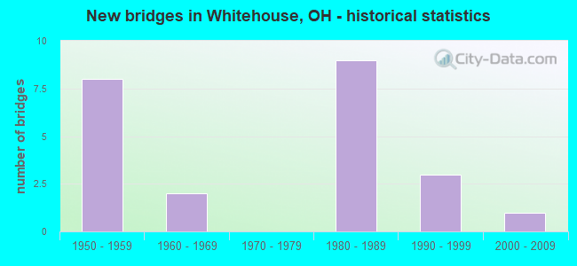
- New bridges - historical statistics
- 81950-1959
- 21960-1969
- 91980-1989
- 31990-1999
- 12000-2009
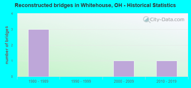
- Reconstructed bridges - Historical Statistics
- 31980-1989
- 01990-1999
- 12000-2009
- 12010-2019
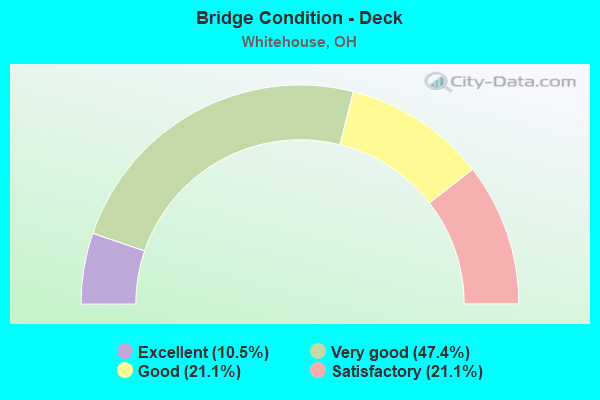
- Bridge Condition - Deck
- 10.5%Excellent
- 47.4%Very good
- 21.1%Good
- 21.1%Satisfactory
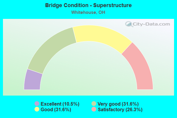
- Bridge Condition - Superstructure
- 10.5%Excellent
- 31.6%Very good
- 31.6%Good
- 26.3%Satisfactory
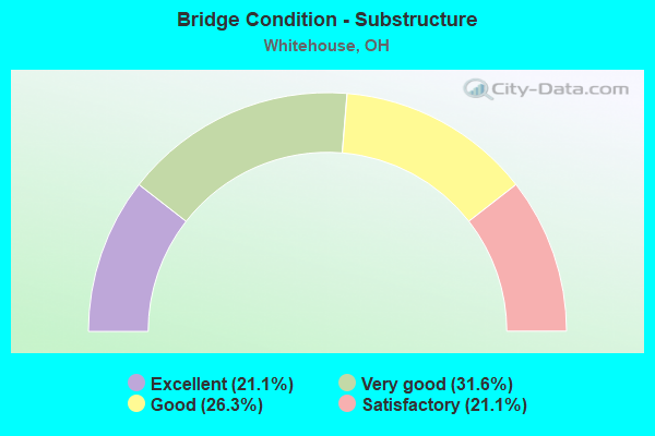
- Bridge Condition - Substructure
- 21.1%Excellent
- 31.6%Very good
- 26.3%Good
- 21.1%Satisfactory
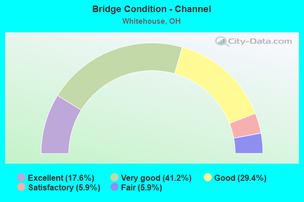
- Bridge Condition - Channel
- 17.6%Excellent
- 41.2%Very good
- 29.4%Good
- 5.9%Satisfactory
- 5.9%Fair
Find on map >> Show street view
Structure Number: 4802497, Location: 0.08 MI W FINZEL RD. (Lat: 41.516531, Lng: -83.783911), Route carried "on" structure: State highway 64, Year Built: 1954, Status: Open, Structure Length: 2.44m (8.01ft), Average Daily Traffic: 8,328 (year 2019), Truck Traffic: 5%, Average Future Daily Traffic: 10,431 (year 2039), Design Load: H 20, Features Intersected: BLUE CREEK
Minimum Vertical Clearance: 30+ m (98+ ft), Kilometerpoint: 6.341, Lanes on structure: 2, Owner: State Highway Agency, Approaching Roadway Width: 8.5m (27.9ft), Material/Design: Concrete continuous, Design/Construction: Slab, Number Of Spans In Main Unit: 3, Length of Maximum Span: 9.1m (29.9ft), Curb-To-Curb Width: 11.0m (36.1ft), Out-to-Out Width: 11.1m (36.4ft)
Condition: Deck: Satisfactory, Superstructure: Satisfactory, Substructure: Satisfactory, Channel: Good, Operating Rating: 25.9 metric tons, Method Used To Determine Operating Rating: Allowable Stress (AS) rating reported by rating factor (RF) method using MS18 loading, Inventory Rating: 19.4 metric tons, Method Used To Determine Inventory Rating: Allowable Stress (AS) rating reported by rating factor (RF) method using MS18 loading, Structural Evaluation: Meets minimum limits, Deck Geometry: Meets minimum limits, Waterway Adequacy: Equal to present desirable criteria, Approach Roadway Alignment: Equal to present desirable criteria, Designated Inspection Frequency: Every 12 months, Inspection Date: January 2022, Deck Structure Type: Concrete Cast-file-Place, Wearing Surface/Protective System: Wearing Surface: Bituminous
Find on map >> Show street view
Structure Number: 4806522, Location: 1.56 Mi. N. of USR 24 (Lat: 41.478739, Lng: -83.826319), Route carried "on" structure: State highway 295, Year Built: 1983, Status: Open, Structure Length: 0.73m (2.40ft), Average Daily Traffic: 2,066 (year 2019), Truck Traffic: 12%, Average Future Daily Traffic: 3,100 (year 2039), Design Load: HS 20+Mod, Features Intersected: HARRIS DITCH
Minimum Vertical Clearance: 30+ m (98+ ft), Kilometerpoint: 8.819, Lanes on structure: 2, Owner: State Highway Agency, Approaching Roadway Width: 7.9m (25.9ft), Skew: 1 degrees, Material/Design: Concrete, Design/Construction: Culvert, Number Of Spans In Main Unit: 2, Length of Maximum Span: 3.0m (9.8ft)
Condition: Channel: Fair, Culverts: Satisfactory, Operating Rating: 42.1 metric tons, Method Used To Determine Operating Rating: Load Factor (LF) rating reported by rating factor (RF) method using MS18 loading, Inventory Rating: 32.4 metric tons, Method Used To Determine Inventory Rating: Load Factor (LF) rating reported by rating factor (RF) method using MS18 loading, Structural Evaluation: Equal to present minimum criteria, Waterway Adequacy: Equal to present desirable criteria, Approach Roadway Alignment: Equal to present desirable criteria, Designated Inspection Frequency: Every 12 months, Inspection Date: January 2022
Find on map >> Show street view
Structure Number: 4806549, Location: 250 Ft. S. of Neapolis-Wa (Lat: 41.494719, Lng: -83.826661), Route carried "on" structure: State highway 295, Year Built: 1965, Year Reconstructed: 2017, Status: Open, Structure Length: 2.23m (7.32ft), Average Daily Traffic: 2,066 (year 2019), Truck Traffic: 12%, Average Future Daily Traffic: 3,100 (year 2039), Design Load: H 15, Features Intersected: BLUE CREEK
Minimum Vertical Clearance: 30+ m (98+ ft), Kilometerpoint: 10.606, Lanes on structure: 2, Owner: State Highway Agency, Approaching Roadway Width: 7.9m (25.9ft), Skew: 3 degrees, Material/Design: Concrete continuous, Design/Construction: Slab, Number Of Spans In Main Unit: 3, Length of Maximum Span: 8.5m (27.9ft), Curb-To-Curb Width: 11.0m (36.1ft), Out-to-Out Width: 11.0m (36.1ft)
Condition: Deck: Satisfactory, Superstructure: Satisfactory, Substructure: Good, Channel: Good, Operating Rating: 29.2 metric tons, Method Used To Determine Operating Rating: Load and Resistance Factor Rating (LRFR) rating reported by rating factor(RF) method using HL-93 loadings, Inventory Rating: 22.7 metric tons, Method Used To Determine Inventory Rating: Load and Resistance Factor Rating (LRFR) rating reported by rating factor(RF) method using HL-93 loadings, Structural Evaluation: Equal to present minimum criteria, Deck Geometry: Somewhat better than minimum adequacy, Waterway Adequacy: Equal to present desirable criteria, Approach Roadway Alignment: Equal to present desirable criteria, Designated Inspection Frequency: Every 12 months, Inspection Date: January 2022, Deck Structure Type: Concrete Cast-file-Place, Wearing Surface/Protective System: Wearing Surface: Integral Concrete, Membrane: Preformed Fabric
Find on map >> Show street view
Structure Number: 4806565, Location: 100 FT. SOUTH OF OBEE RD. (Lat: 41.537939, Lng: -83.824819), Route carried "on" structure: State highway 295, Year Built: 1995, Status: Open, Structure Length: 2.56m (8.40ft), Average Daily Traffic: 2,999 (year 2015), Truck Traffic: 4%, Average Future Daily Traffic: 4,163 (year 2035), Design Load: HS 20+Mod, Features Intersected: SWAN CREEK
Minimum Vertical Clearance: 30+ m (98+ ft), Kilometerpoint: 15.466, Lanes on structure: 2, Owner: State Highway Agency, Approaching Roadway Width: 7.3m (24.0ft), Skew: 1 degrees, Material/Design: Prestressed concrete, Design/Construction: Box Beam or Girders - Multiple, Number Of Spans In Main Unit: 1, Length of Maximum Span: 24.4m (80.1ft), Curb-To-Curb Width: 10.4m (34.1ft), Out-to-Out Width: 10.4m (34.1ft)
Condition: Deck: Very good, Superstructure: Very good, Substructure: Very good, Channel: Satisfactory, Operating Rating: 42.1 metric tons, Method Used To Determine Operating Rating: Load Factor (LF) rating reported by rating factor (RF) method using MS18 loading, Inventory Rating: 32.4 metric tons, Method Used To Determine Inventory Rating: Load Factor (LF) rating reported by rating factor (RF) method using MS18 loading, Structural Evaluation: Equal to present desirable criteria, Deck Geometry: Somewhat better than minimum adequacy, Waterway Adequacy: Equal to present desirable criteria, Approach Roadway Alignment: Equal to present desirable criteria, Designated Inspection Frequency: Every 24 months, Inspection Date: March 2021, Deck Structure Type: Concrete Cast-file-Place, Wearing Surface/Protective System: Wearing Surface: Bituminous, Membrane: Built-up, Deck Protection: Epoxy Coated Reinforcing
Find on map >> Show street view
Structure Number: 4829387, Location: 6.7MI WEST OF EXIT 59 (Lat: 41.598861, Lng: -83.797900), Route carried "on" structure: State highway 2, Year Built: 1954, Year Reconstructed: 1989, Status: Open, Structure Length: 7.86m (25.79ft), Average Daily Traffic: 17,540 (year 2015), Truck Traffic: 13%, Average Future Daily Traffic: 33,899 (year 2035), Design Load: HS 20+Mod, Features Intersected: I80 OHIO TPK
Minimum Vertical Clearance: 30+ m (98+ ft), Kilometerpoint: 7.451, Lanes on structure: 4, Lanes under structure: 4, Base Highway Network: Yes, Owner: State Toll Authority, Approaching Roadway Width: 18.6m (61.0ft), Skew: 4 degrees, Material/Design: Steel continuous, Design/Construction: Stringer/Multi-beam, Number Of Spans In Main Unit: 3, Number Of Approach Spans: 2, Length of Maximum Span: 25.9m (85.0ft), Curb-To-Curb Width: 18.2m (59.7ft), Out-to-Out Width: 19.2m (63.0ft)
Condition: Deck: Good, Superstructure: Good, Substructure: Satisfactory, Operating Rating: 71.3 metric tons, Method Used To Determine Operating Rating: Load Factor (LF) rating reported by rating factor (RF) method using MS18 loading, Inventory Rating: 42.1 metric tons, Method Used To Determine Inventory Rating: Load Factor (LF) rating reported by rating factor (RF) method using MS18 loading, Structural Evaluation: Equal to present minimum criteria, Deck Geometry: Somewhat better than minimum adequacy, Underclear: High priority of corrective action, Approach Roadway Alignment: Equal to present desirable criteria, Designated Inspection Frequency: Every 12 months, Inspection Date: March 2021, Deck Structure Type: Concrete Cast-file-Place, Wearing Surface/Protective System: Wearing Surface: Monolithic Concrete, Deck Protection: Epoxy Coated Reinforcing
Find on map >> Show street view
Structure Number: 4829425, Location: 6.1MI WEST OF EXIT 59 (Lat: 41.595781, Lng: -83.786461), Route carried "on" structure: County highway C0118, Year Built: 1954, Year Reconstructed: 1989, Status: Open, Structure Length: 6.04m (19.82ft), Average Daily Traffic: 157 (year 2015), Truck Traffic: 13%, Average Future Daily Traffic: 33,899 (year 2035), Design Load: HS 20, Features Intersected: I80 OHIO TPK, Facility Carried by Structure: EBER RD
Minimum Vertical Clearance: 30+ m (98+ ft), Kilometerpoint: 6.985, Lanes on structure: 2, Lanes under structure: 4, Owner: State Toll Authority, Approaching Roadway Width: 9.4m (30.8ft), Skew: 1 degrees, Material/Design: Steel continuous, Design/Construction: Stringer/Multi-beam, Number Of Spans In Main Unit: 2, Number Of Approach Spans: 2, Length of Maximum Span: 20.7m (67.9ft), Curb-To-Curb Width: 9.4m (30.8ft), Out-to-Out Width: 10.4m (34.1ft)
Condition: Deck: Good, Superstructure: Good, Substructure: Good, Operating Rating: 77.8 metric tons, Method Used To Determine Operating Rating: Load Factor (LF) rating reported by rating factor (RF) method using MS18 loading, Inventory Rating: 45.4 metric tons, Method Used To Determine Inventory Rating: Load Factor (LF) rating reported by rating factor (RF) method using MS18 loading, Structural Evaluation: Better than present minimum criteria, Deck Geometry: Equal to present minimum criteria, Underclear: High priority of corrective action, Approach Roadway Alignment: Equal to present desirable criteria, Designated Inspection Frequency: Every 24 months, Inspection Date: March 2021, Deck Structure Type: Concrete Cast-file-Place, Wearing Surface/Protective System: Wearing Surface: Monolithic Concrete, Deck Protection: Epoxy Coated Reinforcing
Find on map >> Show street view
Structure Number: 4829441, Location: 4.8MI WEST OF EXIT 59 (Lat: 41.592531, Lng: -83.761381), Route carried "on" structure: County highway C0065, Year Built: 1954, Year Reconstructed: 1989, Status: Open, Structure Length: 6.00m (19.69ft), Average Daily Traffic: 2,386 (year 2015), Truck Traffic: 5%, Average Future Daily Traffic: 33,899 (year 2035), Design Load: HS 20+Mod, Features Intersected: I80 OHIO TPK, Facility Carried by Structure: CRISSEY RD
Minimum Vertical Clearance: 30+ m (98+ ft), Kilometerpoint: 2.108, Lanes on structure: 2, Lanes under structure: 4, Owner: State Toll Authority, Approaching Roadway Width: 8.2m (26.9ft), Material/Design: Steel continuous, Design/Construction: Stringer/Multi-beam, Number Of Spans In Main Unit: 2, Number Of Approach Spans: 2, Length of Maximum Span: 20.4m (66.9ft), Curb-To-Curb Width: 8.2m (26.9ft), Out-to-Out Width: 9.1m (29.9ft)
Condition: Deck: Good, Superstructure: Good, Substructure: Satisfactory, Operating Rating: 74.5 metric tons, Method Used To Determine Operating Rating: Load Factor (LF) rating reported by rating factor (RF) method using MS18 loading, Inventory Rating: 45.4 metric tons, Method Used To Determine Inventory Rating: Load Factor (LF) rating reported by rating factor (RF) method using MS18 loading, Structural Evaluation: Equal to present minimum criteria, Deck Geometry: High priority of corrective action, Underclear: High priority of corrective action, Approach Roadway Alignment: Equal to present desirable criteria, Designated Inspection Frequency: Every 12 months, Inspection Date: May 2021, Deck Structure Type: Concrete Cast-file-Place, Wearing Surface/Protective System: Wearing Surface: Monolithic Concrete, Deck Protection: Epoxy Coated Reinforcing
Find on map >> Show street view
Structure Number: 4830318, Location: 0.2 MI. E. OF WECKERLY RD (Lat: 41.537311, Lng: -83.767600), Route carried "on" structure: County highway C0128, Year Built: 2008, Status: Open, Structure Length: 3.17m (10.40ft), Average Daily Traffic: 214 (year 2015), Truck Traffic: 71%, Average Future Daily Traffic: 297 (year 2035), Design Load: HS 25 or greater, Features Intersected: SWAN CREEK 0781, Facility Carried by Structure: STITT ROAD
Minimum Vertical Clearance: 30+ m (98+ ft), Kilometerpoint: 0.322, Lanes on structure: 2, Owner: County Highway Agency, Approaching Roadway Width: 12.2m (40.0ft), Skew: 2 degrees, Material/Design: Prestressed concrete, Design/Construction: Box Beam or Girders - Multiple, Number Of Spans In Main Unit: 1, Length of Maximum Span: 29.0m (95.1ft), Curb-To-Curb Width: 12.2m (40.0ft), Out-to-Out Width: 12.2m (40.0ft)
Condition: Deck: Excellent, Superstructure: Excellent, Substructure: Excellent, Channel: Excellent, Operating Rating: 42.1 metric tons, Method Used To Determine Operating Rating: Load Factor (LF) rating reported by rating factor (RF) method using MS18 loading, Inventory Rating: 32.4 metric tons, Method Used To Determine Inventory Rating: Load Factor (LF) rating reported by rating factor (RF) method using MS18 loading, Structural Evaluation: Equal to present desirable criteria, Deck Geometry: Superior to present desirable criteria, Waterway Adequacy: Superior to present desirable criteria, Approach Roadway Alignment: Equal to present desirable criteria, Designated Inspection Frequency: Every 24 months, Inspection Date: October 2021, Deck Structure Type: Concrete Cast-file-Place, Wearing Surface/Protective System: Wearing Surface: Monolithic Concrete, Deck Protection: Epoxy Coated Reinforcing
Find on map >> Show street view
Structure Number: 4831578, Location: 0.3 MI. N OF STITT RD. (Lat: 41.541239, Lng: -83.752581), Route carried "on" structure: County highway T0122, Year Built: 1961, Status: Open, Structure Length: 3.23m (10.60ft), Average Daily Traffic: 324 (year 2015), Truck Traffic: 7%, Average Future Daily Traffic: 450 (year 2035), Design Load: H 15, Features Intersected: SWAN CREEK 0728, Facility Carried by Structure: KEENER RD.
Minimum Vertical Clearance: 30+ m (98+ ft), Kilometerpoint: 0.499, Lanes on structure: 2, Owner: County Highway Agency, Approaching Roadway Width: 9.1m (29.9ft), Material/Design: Steel, Design/Construction: Stringer/Multi-beam, Number Of Spans In Main Unit: 1, Length of Maximum Span: 29.9m (98.1ft), Curb or Sidewalk Widths: Left: 0.6m (2.0ft), Right: 0.6m (2.0ft), Curb-To-Curb Width: 7.3m (24.0ft), Out-to-Out Width: 8.5m (27.9ft)
Condition: Deck: Satisfactory, Superstructure: Satisfactory, Substructure: Good, Channel: Good, Operating Rating: 42.1 metric tons, Method Used To Determine Operating Rating: Load Factor (LF) rating reported by rating factor (RF) method using MS18 loading, Inventory Rating: 32.4 metric tons, Method Used To Determine Inventory Rating: Load Factor (LF) rating reported by rating factor (RF) method using MS18 loading, Structural Evaluation: Equal to present minimum criteria, Deck Geometry: Somewhat better than minimum adequacy, Waterway Adequacy: Equal to present desirable criteria, Approach Roadway Alignment: Equal to present desirable criteria, Designated Inspection Frequency: Every 12 months, Inspection Date: October 2021, Deck Structure Type: Concrete Cast-file-Place, Wearing Surface/Protective System: Wearing Surface: Bituminous, Membrane: Built-up
Find on map >> Show street view
Structure Number: 4832027, Location: 0.17 MI. N. OF SALISBURY (Lat: 41.582381, Lng: -83.768789), Route carried "on" structure: County highway T0091, Year Built: 1981, Status: Open, Structure Length: 0.76m (2.49ft), Average Daily Traffic: 429 (year 2015), Truck Traffic: 5%, Average Future Daily Traffic: 595 (year 2035), Design Load: HS 20+Mod, Features Intersected: ZALESKI DITCH 0635, Facility Carried by Structure: WECKERLY RD.
Minimum Vertical Clearance: 30+ m (98+ ft), Kilometerpoint: 10.219, Lanes on structure: 2, Owner: County Highway Agency, Approaching Roadway Width: 9.8m (32.2ft), Skew: 2 degrees, Material/Design: Concrete, Design/Construction: Slab, Number Of Spans In Main Unit: 1, Length of Maximum Span: 6.7m (22.0ft), Curb-To-Curb Width: 9.8m (32.2ft), Out-to-Out Width: 10.2m (33.5ft)
Condition: Deck: Very good, Superstructure: Very good, Substructure: Good, Channel: Good, Operating Rating: 42.1 metric tons, Method Used To Determine Operating Rating: Load Factor (LF) rating reported by rating factor (RF) method using MS18 loading, Inventory Rating: 32.4 metric tons, Method Used To Determine Inventory Rating: Load Factor (LF) rating reported by rating factor (RF) method using MS18 loading, Structural Evaluation: Better than present minimum criteria, Deck Geometry: Equal to present minimum criteria, Waterway Adequacy: Equal to present desirable criteria, Approach Roadway Alignment: Better than present minimum criteria, Designated Inspection Frequency: Every 24 months, Inspection Date: October 2021, Deck Structure Type: Concrete Cast-file-Place, Wearing Surface/Protective System: Wearing Surface: Monolithic Concrete, Deck Protection: Epoxy Coated Reinforcing
Find on map >> Show street view
Structure Number: 4832051, Location: 0.4 MI. E. OF MIDWAY RD. (Lat: 41.480989, Lng: -83.819011), Route carried "on" structure: County highway T0142, Year Built: 1982, Status: Open, Structure Length: 1.49m (4.89ft), Average Daily Traffic: 797 (year 2015), Truck Traffic: 8%, Average Future Daily Traffic: 1,106 (year 2035), Design Load: HS 20+Mod, Features Intersected: HARRIS DITCH 0968, Facility Carried by Structure: DORAN RD.
Minimum Vertical Clearance: 30+ m (98+ ft), Kilometerpoint: 15.578, Lanes on structure: 2, Owner: County Highway Agency, Approaching Roadway Width: 7.9m (25.9ft), Skew: 5 degrees, Material/Design: Concrete, Design/Construction: Slab, Number Of Spans In Main Unit: 1, Length of Maximum Span: 13.7m (44.9ft), Curb-To-Curb Width: 8.5m (27.9ft), Out-to-Out Width: 9.0m (29.5ft)
Condition: Deck: Very good, Superstructure: Good, Substructure: Very good, Channel: Good, Operating Rating: 42.1 metric tons, Method Used To Determine Operating Rating: Load Factor (LF) rating reported by rating factor (RF) method using MS18 loading, Inventory Rating: 32.4 metric tons, Method Used To Determine Inventory Rating: Load Factor (LF) rating reported by rating factor (RF) method using MS18 loading, Structural Evaluation: Better than present minimum criteria, Deck Geometry: Somewhat better than minimum adequacy, Waterway Adequacy: Superior to present desirable criteria, Approach Roadway Alignment: Equal to present desirable criteria, Designated Inspection Frequency: Every 24 months, Inspection Date: October 2021, Deck Structure Type: Concrete Cast-file-Place, Wearing Surface/Protective System: Wearing Surface: Monolithic Concrete, Deck Protection: Epoxy Coated Reinforcing
Find on map >> Show street view
Structure Number: 4832108, Location: 0.35 MI. N. OF SALISBURY. (Lat: 41.586081, Lng: -83.761339), Route carried "on" structure: County highway C0065, Year Built: 1984, Status: Open, Structure Length: 0.67m (2.20ft), Average Daily Traffic: 2,386 (year 2015), Truck Traffic: 5%, Average Future Daily Traffic: 3,312 (year 2035), Design Load: HS 20+Mod, Features Intersected: ZALESKI DITCH 0511, Facility Carried by Structure: CRISSEY RD.
Minimum Vertical Clearance: 30+ m (98+ ft), Kilometerpoint: 8.224, Lanes on structure: 2, Owner: County Highway Agency, Approaching Roadway Width: 10.4m (34.1ft), Skew: 2 degrees, Material/Design: Concrete, Design/Construction: Frame, Number Of Spans In Main Unit: 2, Length of Maximum Span: 3.0m (9.8ft), Curb-To-Curb Width: 7.9m (25.9ft), Out-to-Out Width: 7.9m (25.9ft)
Condition: Deck: Very good, Superstructure: Very good, Substructure: Very good, Channel: Very good, Operating Rating: 42.1 metric tons, Method Used To Determine Operating Rating: Load Factor (LF) rating reported by rating factor (RF) method using MS18 loading, Inventory Rating: 32.4 metric tons, Method Used To Determine Inventory Rating: Load Factor (LF) rating reported by rating factor (RF) method using MS18 loading, Structural Evaluation: Equal to present desirable criteria, Deck Geometry: High priority of corrective action, Waterway Adequacy: Superior to present desirable criteria, Approach Roadway Alignment: Superior to present desirable criteria, Designated Inspection Frequency: Every 24 months, Inspection Date: October 2021, Deck Structure Type: Concrete Cast-file-Place, Wearing Surface/Protective System: Wearing Surface: Bituminous
Find on map >> Show street view
Structure Number: 4832213, Location: 0.02 MI. W. OF EBER RD. (Lat: 41.534881, Lng: -83.782950), Route carried "on" structure: County highway C0120, Year Built: 1983, Status: Open, Structure Length: 2.99m (9.81ft), Average Daily Traffic: 214 (year 2015), Truck Traffic: 5%, Average Future Daily Traffic: 297 (year 2035), Design Load: HS 20+Mod, Features Intersected: SWAN CREEK 0780, Facility Carried by Structure: WECKERLY RD.
Minimum Vertical Clearance: 30+ m (98+ ft), Kilometerpoint: 12.553, Lanes on structure: 3, Owner: County Highway Agency, Approaching Roadway Width: 14.6m (47.9ft), Material/Design: Concrete continuous, Design/Construction: Slab, Number Of Spans In Main Unit: 3, Length of Maximum Span: 11.0m (36.1ft), Curb-To-Curb Width: 15.9m (52.2ft), Out-to-Out Width: 16.2m (53.1ft)
Condition: Deck: Good, Superstructure: Good, Substructure: Satisfactory, Channel: Very good, Operating Rating: 42.1 metric tons, Method Used To Determine Operating Rating: Load Factor (LF) rating reported by rating factor (RF) method using MS18 loading, Inventory Rating: 32.4 metric tons, Method Used To Determine Inventory Rating: Load Factor (LF) rating reported by rating factor (RF) method using MS18 loading, Structural Evaluation: Equal to present minimum criteria, Deck Geometry: Better than present minimum criteria, Waterway Adequacy: Superior to present desirable criteria, Approach Roadway Alignment: Equal to present desirable criteria, Designated Inspection Frequency: Every 12 months, Inspection Date: October 2021, Deck Structure Type: Concrete Cast-file-Place, Wearing Surface/Protective System: Wearing Surface: Monolithic Concrete, Deck Protection: Epoxy Coated Reinforcing
Find on map >> Show street view
Structure Number: 4832221, Location: 0.1 MI N OF NEAP-WATRVIL (Lat: 41.497119, Lng: -83.797600), Route carried "on" structure: County highway C0152, Year Built: 1983, Status: Open, Structure Length: 2.01m (6.59ft), Average Daily Traffic: 309 (year 2015), Truck Traffic: 8%, Average Future Daily Traffic: 429 (year 2035), Design Load: HS 20+Mod, Features Intersected: BLUE CREEK 0789, Facility Carried by Structure: SCHADEL
Minimum Vertical Clearance: 30+ m (98+ ft), Kilometerpoint: 12.698, Lanes on structure: 2, Owner: County Highway Agency, Approaching Roadway Width: 9.1m (29.9ft), Skew: 1 degrees, Material/Design: Prestressed concrete, Design/Construction: Box Beam or Girders - Multiple, Number Of Spans In Main Unit: 1, Length of Maximum Span: 18.9m (62.0ft), Curb-To-Curb Width: 9.4m (30.8ft), Out-to-Out Width: 9.8m (32.2ft)
Condition: Deck: Very good, Superstructure: Good, Substructure: Very good, Channel: Very good, Operating Rating: 42.1 metric tons, Method Used To Determine Operating Rating: Load Factor (LF) rating reported by rating factor (RF) method using MS18 loading, Inventory Rating: 32.4 metric tons, Method Used To Determine Inventory Rating: Load Factor (LF) rating reported by rating factor (RF) method using MS18 loading, Structural Evaluation: Better than present minimum criteria, Deck Geometry: Equal to present minimum criteria, Waterway Adequacy: Superior to present desirable criteria, Approach Roadway Alignment: Equal to present desirable criteria, Designated Inspection Frequency: Every 24 months, Inspection Date: October 2021, Deck Structure Type: Concrete Cast-file-Place, Wearing Surface/Protective System: Wearing Surface: Monolithic Concrete, Deck Protection: Epoxy Coated Reinforcing
Find on map >> Show street view
Structure Number: 4832388, Location: 0.03 MI. N OF WECKERLY RD (Lat: 41.530911, Lng: -83.790650), Route carried "on" structure: County highway C0119, Year Built: 1988, Status: Open, Structure Length: 3.23m (10.60ft), Average Daily Traffic: 351 (year 2015), Truck Traffic: 7%, Average Future Daily Traffic: 487 (year 2035), Design Load: HS 20+Mod, Features Intersected: SWAN CREEK 0779, Facility Carried by Structure: DAVIS RD.
Minimum Vertical Clearance: 30+ m (98+ ft), Kilometerpoint: 12.537, Lanes on structure: 2, Owner: County Highway Agency, Approaching Roadway Width: 10.4m (34.1ft), Material/Design: Concrete continuous, Design/Construction: Slab, Number Of Spans In Main Unit: 3, Length of Maximum Span: 12.2m (40.0ft), Curb-To-Curb Width: 10.4m (34.1ft), Out-to-Out Width: 10.8m (35.4ft)
Condition: Deck: Very good, Superstructure: Very good, Substructure: Very good, Channel: Very good, Operating Rating: 42.1 metric tons, Method Used To Determine Operating Rating: Load Factor (LF) rating reported by rating factor (RF) method using MS18 loading, Inventory Rating: 32.4 metric tons, Method Used To Determine Inventory Rating: Load Factor (LF) rating reported by rating factor (RF) method using MS18 loading, Structural Evaluation: Equal to present desirable criteria, Deck Geometry: Better than present minimum criteria, Waterway Adequacy: Superior to present desirable criteria, Approach Roadway Alignment: Superior to present desirable criteria, Designated Inspection Frequency: Every 24 months, Inspection Date: October 2021, Deck Structure Type: Concrete Cast-file-Place, Wearing Surface/Protective System: Wearing Surface: Monolithic Concrete, Deck Protection: Epoxy Coated Reinforcing
Find on map >> Show street view
Structure Number: 4832396, Location: 0.1 MI S OF NEAP-WATRVILE (Lat: 41.494639, Lng: -83.807381), Route carried "on" structure: County highway C0151, Year Built: 1989, Status: Open, Structure Length: 1.92m (6.30ft), Average Daily Traffic: 371 (year 2015), Truck Traffic: 8%, Average Future Daily Traffic: 515 (year 2035), Design Load: HS 20+Mod, Features Intersected: BLUE CREEK 0866, Facility Carried by Structure: HELLER RD.
Minimum Vertical Clearance: 30+ m (98+ ft), Kilometerpoint: 13.937, Lanes on structure: 2, Owner: County Highway Agency, Approaching Roadway Width: 9.8m (32.2ft), Material/Design: Concrete continuous, Design/Construction: Slab, Number Of Spans In Main Unit: 3, Length of Maximum Span: 7.0m (23.0ft), Curb-To-Curb Width: 10.4m (34.1ft), Out-to-Out Width: 10.4m (34.1ft)
Condition: Deck: Very good, Superstructure: Very good, Substructure: Excellent, Channel: Excellent, Operating Rating: 42.1 metric tons, Method Used To Determine Operating Rating: Load Factor (LF) rating reported by rating factor (RF) method using MS18 loading, Inventory Rating: 32.4 metric tons, Method Used To Determine Inventory Rating: Load Factor (LF) rating reported by rating factor (RF) method using MS18 loading, Structural Evaluation: Equal to present desirable criteria, Deck Geometry: Better than present minimum criteria, Waterway Adequacy: Superior to present desirable criteria, Approach Roadway Alignment: Equal to present desirable criteria, Designated Inspection Frequency: Every 24 months, Inspection Date: October 2021, Deck Structure Type: Concrete Cast-file-Place, Wearing Surface/Protective System: Wearing Surface: Monolithic Concrete, Deck Protection: Epoxy Coated Reinforcing
Find on map >> Show street view
Structure Number: 4832418, Location: 0.6 MI. N. OF DORAN RD (Lat: 41.489369, Lng: -83.807250), Route carried "on" structure: County highway C0151, Year Built: 1989, Status: Open, Structure Length: 2.29m (7.51ft), Average Daily Traffic: 371 (year 2015), Truck Traffic: 8%, Average Future Daily Traffic: 515 (year 2035), Design Load: HS 20+Mod, Features Intersected: HARRIS DITCH 0867, Facility Carried by Structure: HELLER RD.
Minimum Vertical Clearance: 30+ m (98+ ft), Kilometerpoint: 13.953, Lanes on structure: 2, Owner: County Highway Agency, Approaching Roadway Width: 9.8m (32.2ft), Skew: 4 degrees, Material/Design: Concrete continuous, Design/Construction: Slab, Number Of Spans In Main Unit: 3, Length of Maximum Span: 8.2m (26.9ft), Curb-To-Curb Width: 10.4m (34.1ft), Out-to-Out Width: 10.4m (34.1ft)
Condition: Deck: Very good, Superstructure: Very good, Substructure: Very good, Channel: Very good, Operating Rating: 42.1 metric tons, Method Used To Determine Operating Rating: Load Factor (LF) rating reported by rating factor (RF) method using MS18 loading, Inventory Rating: 32.4 metric tons, Method Used To Determine Inventory Rating: Load Factor (LF) rating reported by rating factor (RF) method using MS18 loading, Structural Evaluation: Equal to present desirable criteria, Deck Geometry: Better than present minimum criteria, Waterway Adequacy: Superior to present desirable criteria, Approach Roadway Alignment: Equal to present desirable criteria, Designated Inspection Frequency: Every 24 months, Inspection Date: October 2021, Deck Structure Type: Concrete Cast-file-Place, Wearing Surface/Protective System: Wearing Surface: Monolithic Concrete, Deck Protection: Epoxy Coated Reinforcing
Find on map >> Show street view
Structure Number: 4832531, Location: 0.09 M. N. OF WINSLOW RD. (Lat: 41.533311, Lng: -83.805561), Route carried "on" structure: County highway C0117, Year Built: 1994, Status: Open, Structure Length: 3.32m (10.89ft), Average Daily Traffic: 214 (year 2015), Truck Traffic: 5%, Average Future Daily Traffic: 297 (year 2035), Design Load: HS 20+Mod, Features Intersected: SWAN CREEK 0777, Facility Carried by Structure: WHITEHOUSE-SPENCER
Minimum Vertical Clearance: 30+ m (98+ ft), Kilometerpoint: 12.505, Lanes on structure: 2, Owner: County Highway Agency, Approaching Roadway Width: 10.4m (34.1ft), Skew: 3 degrees, Material/Design: Prestressed concrete continuous, Design/Construction: Box Beam or Girders - Multiple, Number Of Spans In Main Unit: 3, Length of Maximum Span: 11.0m (36.1ft), Curb-To-Curb Width: 10.4m (34.1ft), Out-to-Out Width: 10.4m (34.1ft)
Condition: Deck: Very good, Superstructure: Satisfactory, Substructure: Excellent, Channel: Very good, Operating Rating: 38.9 metric tons, Method Used To Determine Operating Rating: Load Factor (LF) rating reported by rating factor (RF) method using MS18 loading, Inventory Rating: 22.7 metric tons, Method Used To Determine Inventory Rating: Load Factor (LF) rating reported by rating factor (RF) method using MS18 loading, Structural Evaluation: Equal to present minimum criteria, Deck Geometry: Better than present minimum criteria, Waterway Adequacy: Superior to present desirable criteria, Approach Roadway Alignment: Superior to present desirable criteria, Designated Inspection Frequency: Every 12 months, Inspection Date: October 2021, Deck Structure Type: Concrete Cast-file-Place, Wearing Surface/Protective System: Wearing Surface: Monolithic Concrete, Deck Protection: Epoxy Coated Reinforcing
Find on map >> Show street view
Structure Number: 483259, Location: 0.1 MI. W. OF SCHADEL RD. (Lat: 41.495689, Lng: -83.799631), Route carried "on" structure: County highway C0136, Year Built: 1998, Status: Open, Structure Length: 1.77m (5.81ft), Average Daily Traffic: 2,637 (year 2015), Truck Traffic: 8%, Average Future Daily Traffic: 3,660 (year 2035), Design Load: HS 20+Mod, Features Intersected: BLUE CREEK 0790, Facility Carried by Structure: NEAPOLIS-WATERVILL
Minimum Vertical Clearance: 30+ m (98+ ft), Kilometerpoint: 6.231, Lanes on structure: 2, Owner: County Highway Agency, Approaching Roadway Width: 12.2m (40.0ft), Material/Design: Prestressed concrete, Design/Construction: Box Beam or Girders - Multiple, Number Of Spans In Main Unit: 1, Length of Maximum Span: 16.8m (55.1ft), Curb-To-Curb Width: 12.2m (40.0ft), Out-to-Out Width: 12.2m (40.0ft)
Condition: Deck: Excellent, Superstructure: Excellent, Substructure: Excellent, Channel: Excellent, Operating Rating: 42.1 metric tons, Method Used To Determine Operating Rating: Load Factor (LF) rating reported by rating factor (RF) method using MS18 loading, Inventory Rating: 32.4 metric tons, Method Used To Determine Inventory Rating: Load Factor (LF) rating reported by rating factor (RF) method using MS18 loading, Structural Evaluation: Equal to present desirable criteria, Deck Geometry: Equal to present minimum criteria, Waterway Adequacy: Superior to present desirable criteria, Approach Roadway Alignment: Superior to present desirable criteria, Designated Inspection Frequency: Every 24 months, Inspection Date: October 2021, Deck Structure Type: Concrete Cast-file-Place, Wearing Surface/Protective System: Wearing Surface: Monolithic Concrete, Deck Protection: Epoxy Coated Reinforcing
Find on map >> Show street view
Structure Number: 4864077, Location: 0.40 M. N. OF DUTCH ROAD (Lat: 41.527081, Lng: -83.781011), Route carried "on" structure: City street M-FIN, Year Built: 1953, Year Reconstructed: 2013, Status: Posted for load, Structure Length: 1.59m (5.22ft), Average Daily Traffic: 4,094 (year 2019), Truck Traffic: 5%, Average Future Daily Traffic: 5,682 (year 2039), Design Load: HS 20+Mod, Features Intersected: BLUE CREEK 0787, Facility Carried by Structure: FINZEL ROAD
Minimum Vertical Clearance: 30+ m (98+ ft), Kilometerpoint: 12.666, Lanes on structure: 2, Owner: City or Municipal Highway Agency, Approaching Roadway Width: 9.8m (32.2ft), Material/Design: Concrete, Design/Construction: Frame, Number Of Spans In Main Unit: 1, Length of Maximum Span: 14.9m (48.9ft), Curb or Sidewalk Widths: Left: 0.6m (2.0ft), Right: 0.6m (2.0ft), Curb-To-Curb Width: 12.2m (40.0ft), Out-to-Out Width: 12.2m (40.0ft)
Condition: Deck: Satisfactory, Superstructure: Satisfactory, Substructure: Good, Channel: Very good, Operating Rating: 35.6 metric tons, Method Used To Determine Operating Rating: Load Factor (LF) rating reported by rating factor (RF) method using MS18 loading, Inventory Rating: 19.4 metric tons, Method Used To Determine Inventory Rating: Load Factor (LF) rating reported by rating factor (RF) method using MS18 loading, Structural Evaluation: Somewhat better than minimum adequacy, Deck Geometry: Equal to present minimum criteria, Waterway Adequacy: Equal to present desirable criteria, Approach Roadway Alignment: Better than present minimum criteria, Bridge Posting: Required (Relationship of Operating Rating to Maximum Legal Load: 20.0 - 29.9% below), Designated Inspection Frequency: Every 12 months, Inspection Date: July 2021, Deck Structure Type: Concrete Cast-file-Place, Wearing Surface/Protective System: Wearing Surface: Bituminous
Find on map >> Show street view
Structure Number: 4829387, Location: 6.7MI WEST OF EXIT 59 (Lat: 41.598861, Lng: -83.797900), Route carried "under" structure: Interstate 80K, Year Built: 1954, Structure Length: 0. m, Average Daily Traffic: 24,423 (year 2015), Truck Traffic: 43%, Features Intersected: SR 2, Facility Carried by Structure: I80 OH TPK
Minimum Vertical Clearance: 4.65m (15.26ft), Kilometerpoint: 7.178, Lanes on structure: 4, Lanes under structure: 4, Toll: On toll road, Material/Design: Steel continuous, Design/Construction: Stringer/Multi-beam, Length of Maximum Span: 25.9m (85.0ft)
Find on map >> Show street view
Structure Number: 4829425, Location: 6.1MI WEST OF EXIT 59 (Lat: 41.595781, Lng: -83.786461), Route carried "under" structure: Interstate 80K, Year Built: 1954, Structure Length: 0. m, Average Daily Traffic: 24,423 (year 2015), Truck Traffic: 43%, Features Intersected: EBER RD, Facility Carried by Structure: I80 OH TPK
Minimum Vertical Clearance: 4.52m (14.83ft), Kilometerpoint: 8.143, Lanes on structure: 2, Lanes under structure: 4, Toll: On toll road, Material/Design: Steel continuous, Design/Construction: Stringer/Multi-beam, Length of Maximum Span: 20.7m (67.9ft)
Find on map >> Show street view
Structure Number: 4829441, Location: 4.8MI WEST OF EXIT 59 (Lat: 41.592531, Lng: -83.761381), Route carried "under" structure: Interstate 80K, Year Built: 1954, Structure Length: 0. m, Average Daily Traffic: 24,423 (year 2015), Truck Traffic: 43%, Features Intersected: CRISSEY RD MP, Facility Carried by Structure: I80 OH TPK
Minimum Vertical Clearance: 4.47m (14.67ft), Kilometerpoint: 10.268, Lanes on structure: 2, Lanes under structure: 4, Toll: On toll road, Material/Design: Steel continuous, Design/Construction: Stringer/Multi-beam, Length of Maximum Span: 20.4m (66.9ft)