Bridge Statistics for Whitehouse, Texas (TX)
Condition, Traffic, Stress, Structural Evaluation, Project Costs
- National Bridge Inventory (NBI) Statistics
- 15Number of bridges
- 144ft / 44.1mTotal length
- $1,000Total costs
- 66,849Total average daily traffic
- 6,764Total average daily truck traffic
- National Bridge Inventory (NBI) Registered Bridges for Whitehouse
- No street view available for this location
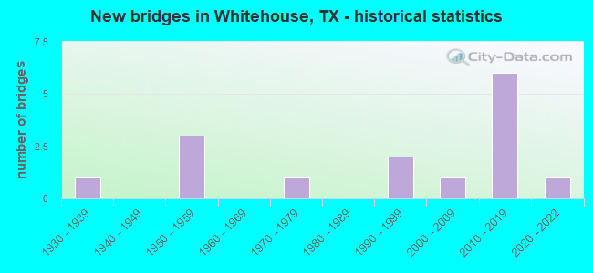
- New bridges - historical statistics
- 11930-1939
- 31950-1959
- 11970-1979
- 21990-1999
- 12000-2009
- 62010-2019
- 12020-2022
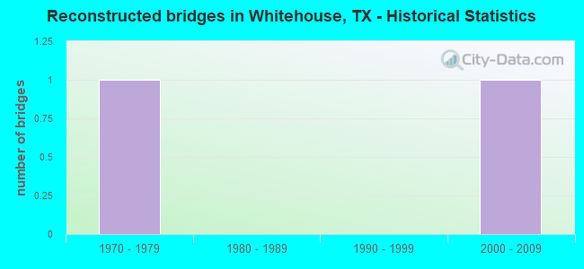
- Reconstructed bridges - Historical Statistics
- 11970-1979
- 01980-1989
- 01990-1999
- 12000-2009
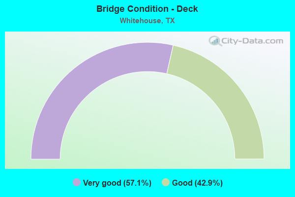
- Bridge Condition - Deck
- 57.1%Very good
- 42.9%Good
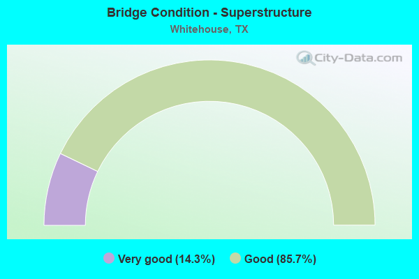
- Bridge Condition - Superstructure
- 14.3%Very good
- 85.7%Good
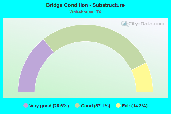
- Bridge Condition - Substructure
- 28.6%Very good
- 57.1%Good
- 14.3%Fair
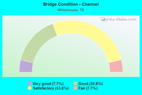
- Bridge Condition - Channel
- 7.7%Very good
- 30.8%Good
- 53.8%Satisfactory
- 7.7%Fair
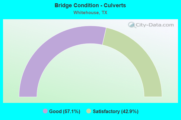
- Bridge Condition - Culverts
- 57.1%Good
- 42.9%Satisfactory
Find on map >> Show street view
Structure Number: 102120034501021, Location: 2.3 MI S OF FM 2964 (Lat: 32.267608, Lng: -95.240719), Route carried "on" structure: State highway 110, Year Built: 1959, Year Reconstructed: 2011, Status: Open, Structure Length: 0.67m (2.20ft), Average Daily Traffic: 15,974 (year 2018), Truck Traffic: 17%, Average Future Daily Traffic: 24,430 (year 2033), Features Intersected: HILL CREEK
Minimum Vertical Clearance: 30+ m (98+ ft), Kilometerpoint: 9.970, Lanes on structure: 5, Owner: State Highway Agency, Approaching Roadway Width: 25.6m (84.0ft), Skew: 9 degrees, Material/Design: Concrete, Design/Construction: Culvert, Number Of Spans In Main Unit: 2, Length of Maximum Span: 3.0m (9.8ft), Out-to-Out Width: 69.5m (228.0ft)
Condition: Channel: Satisfactory, Culverts: Satisfactory, Operating Rating: 39.9 metric tons, Method Used To Determine Operating Rating: Load Factor (LF), Inventory Rating: 23.6 metric tons, Method Used To Determine Inventory Rating: Load Factor (LF), Structural Evaluation: Somewhat better than minimum adequacy, Waterway Adequacy: Equal to present minimum criteria, Approach Roadway Alignment: Equal to present desirable criteria, Designated Inspection Frequency: Every 24 months, Inspection Date: March 2021
Find on map >> Show street view
Structure Number: 102120034501022, Location: 3.9 MI SE OF FM 2964 (Lat: 32.245822, Lng: -95.233425), Route carried "on" structure: State highway 110, Year Built: 1959, Year Reconstructed: 1981, Status: Open, Structure Length: 1.31m (4.30ft), Average Daily Traffic: 15,540 (year 2020), Truck Traffic: 17%, Average Future Daily Traffic: 27,730 (year 2033), Features Intersected: TRIB OF HILL CREEK
Minimum Vertical Clearance: 30+ m (98+ ft), Kilometerpoint: 12.495, Lanes on structure: 5, Owner: State Highway Agency, Approaching Roadway Width: 25.6m (84.0ft), Material/Design: Concrete, Design/Construction: Culvert, Number Of Spans In Main Unit: 4, Length of Maximum Span: 3.0m (9.8ft), Curb-To-Curb Width: 25.6m (84.0ft), Out-to-Out Width: 38.9m (127.6ft)
Condition: Channel: Satisfactory, Culverts: Good, Operating Rating: 39.9 metric tons, Method Used To Determine Operating Rating: Load Factor (LF), Inventory Rating: 23.6 metric tons, Method Used To Determine Inventory Rating: Load Factor (LF), Structural Evaluation: Somewhat better than minimum adequacy, Deck Geometry: Superior to present desirable criteria, Waterway Adequacy: Equal to present minimum criteria, Approach Roadway Alignment: Equal to present desirable criteria, Designated Inspection Frequency: Every 24 months, Inspection Date: March 2021, Deck Structure Type: Concrete Cast-file-Place, Wearing Surface/Protective System: Wearing Surface: Bituminous
Find on map >> Show street view
Structure Number: 102120034502023, Location: 1.3 MI SE OF FM 346 (Lat: 32.208986, Lng: -95.218356), Route carried "on" structure: State highway 110, Year Built: 1959, Status: Open, Structure Length: 1.01m (3.31ft), Average Daily Traffic: 7,705 (year 2020), Truck Traffic: 8%, Average Future Daily Traffic: 13,930 (year 2033), Features Intersected: BLACK HAWK CREEK
Minimum Vertical Clearance: 30+ m (98+ ft), Kilometerpoint: 16.868, Lanes on structure: 2, Owner: State Highway Agency, Approaching Roadway Width: 12.8m (42.0ft), Material/Design: Concrete, Design/Construction: Culvert, Number Of Spans In Main Unit: 3, Length of Maximum Span: 3.0m (9.8ft), Curb-To-Curb Width: 12.8m (42.0ft), Out-to-Out Width: 16.2m (53.1ft)
Condition: Channel: Satisfactory, Culverts: Satisfactory, Operating Rating: 39.9 metric tons, Method Used To Determine Operating Rating: Load Factor (LF), Inventory Rating: 23.6 metric tons, Method Used To Determine Inventory Rating: Load Factor (LF), Structural Evaluation: Somewhat better than minimum adequacy, Deck Geometry: Somewhat better than minimum adequacy, Waterway Adequacy: Equal to present minimum criteria, Approach Roadway Alignment: Equal to present desirable criteria, Designated Inspection Frequency: Every 24 months, Inspection Date: March 2021, Deck Structure Type: Concrete Cast-file-Place, Wearing Surface/Protective System: Wearing Surface: Bituminous
Find on map >> Show street view
Structure Number: 102120049205149, Location: 0.9 MI W OF FM 3341 (Lat: 32.204697, Lng: -95.173675), Route carried "on" structure: State highway 346, Year Built: 2020, Status: Open, Structure Length: 5.49m (18.01ft), Average Daily Traffic: 2,263 (year 2020), Truck Traffic: 3%, Average Future Daily Traffic: 1 (year 1900), Design Load: HL 93, Features Intersected: Prairie Cr
Minimum Vertical Clearance: 30+ m (98+ ft), Kilometerpoint: 23.142, Lanes on structure: 2, Owner: State Highway Agency, Approaching Roadway Width: 13.4m (44.0ft), Material/Design: Prestressed concrete, Design/Construction: Stringer/Multi-beam, Number Of Spans In Main Unit: 1, Number Of Approach Spans: 2, Length of Maximum Span: 24.4m (80.1ft), Curb-To-Curb Width: 13.1m (43.0ft), Out-to-Out Width: 14.0m (45.9ft)
Condition: Deck: Very good, Superstructure: Good, Substructure: Very good, Channel: Very good, Operating Rating: 54.4 metric tons, Method Used To Determine Operating Rating: Assigned ratings based on Load and Resistance Factor Design (LRFD) reported in metric tons, Inventory Rating: 32.7 metric tons, Method Used To Determine Inventory Rating: Assigned ratings based on Load and Resistance Factor Design (LRFD) reported in metric tons, Structural Evaluation: Better than present minimum criteria, Deck Geometry: Equal to present minimum criteria, Waterway Adequacy: Superior to present desirable criteria, Approach Roadway Alignment: Equal to present desirable criteria, Designated Inspection Frequency: Every 24 months, Inspection Date: March 2021, Deck Structure Type: Concrete Precast Panels, Wearing Surface/Protective System: Wearing Surface: Monolithic Concrete
Find on map >> Show street view
Structure Number: 102120092701003, Location: 0.5 MI E OF FM 756 (Lat: 32.177808, Lng: -95.247353), Route carried "on" structure: State highway 344, Year Built: 1937, Status: Open, Structure Length: 0.70m (2.30ft), Average Daily Traffic: 2,287 (year 2020), Truck Traffic: 2%, Average Future Daily Traffic: 2,770 (year 2033), Design Load: H 15, Features Intersected: BRIAR BRANCH
Minimum Vertical Clearance: 30+ m (98+ ft), Kilometerpoint: 25.780, Lanes on structure: 2, Owner: State Highway Agency, Approaching Roadway Width: 7.6m (24.9ft), Material/Design: Concrete, Design/Construction: Culvert, Number Of Spans In Main Unit: 2, Length of Maximum Span: 3.0m (9.8ft), Curb-To-Curb Width: 7.6m (24.9ft), Out-to-Out Width: 9.9m (32.5ft)
Condition: Channel: Satisfactory, Culverts: Satisfactory, Operating Rating: 32.7 metric tons, Method Used To Determine Operating Rating: Field evaluation and documented engineering judgment, Inventory Rating: 24.5 metric tons, Method Used To Determine Inventory Rating: Field evaluation and documented engineering judgment, Structural Evaluation: Equal to present minimum criteria, Deck Geometry: High priority of replacement, Waterway Adequacy: Equal to present minimum criteria, Approach Roadway Alignment: Equal to present desirable criteria, Length Of Structure Improvement: 0.70m (2.30ft), Designated Inspection Frequency: Every 24 months, Inspection Date: March 2021, Bridge Improvement Cost: $1,000, Total Project Cost: $1,000, Deck Structure Type: Concrete Cast-file-Place, Wearing Surface/Protective System: Wearing Surface: Bituminous
Find on map >> Show street view
Structure Number: 102120115101003, Location: 2.5 MI NE OF FM 346 (Lat: 32.256064, Lng: -95.200403), Route carried "on" structure: State highway 848, Year Built: 1991, Status: Open, Structure Length: 4.57m (14.99ft), Average Daily Traffic: 4,004 (year 2018), Truck Traffic: 6%, Average Future Daily Traffic: 4,910 (year 2033), Design Load: HS 20, Features Intersected: GILLEY CREEK
Minimum Vertical Clearance: 30+ m (98+ ft), Kilometerpoint: 7.966, Lanes on structure: 2, Owner: State Highway Agency, Approaching Roadway Width: 8.5m (27.9ft), Skew: 2 degrees, Material/Design: Prestressed concrete, Number Of Spans In Main Unit: 5, Length of Maximum Span: 9.1m (29.9ft), Curb-To-Curb Width: 13.4m (44.0ft), Out-to-Out Width: 14.1m (46.3ft)
Condition: Deck: Very good, Superstructure: Good, Substructure: Good, Channel: Satisfactory, Operating Rating: 54.4 metric tons, Method Used To Determine Operating Rating: Assigned rating based on Load Factor Design (LFD) reported in metric tons, Inventory Rating: 32.7 metric tons, Method Used To Determine Inventory Rating: Assigned rating based on Load Factor Design (LFD) reported in metric tons, Structural Evaluation: Better than present minimum criteria, Deck Geometry: Better than present minimum criteria, Waterway Adequacy: Superior to present desirable criteria, Approach Roadway Alignment: Equal to present desirable criteria, Designated Inspection Frequency: Every 24 months, Inspection Date: March 2021, Deck Structure Type: Concrete Precast Panels, Wearing Surface/Protective System: Wearing Surface: Bituminous
Find on map >> Show street view
Structure Number: 102120115101004, Location: 1.1 MI N OF FM 346 (Lat: 32.241406, Lng: -95.215658), Route carried "on" structure: State highway 848, Year Built: 1991, Status: Open, Structure Length: 3.90m (12.80ft), Average Daily Traffic: 4,004 (year 2018), Truck Traffic: 6%, Average Future Daily Traffic: 4,910 (year 2033), Design Load: HS 20, Features Intersected: HILL CREEK
Minimum Vertical Clearance: 30+ m (98+ ft), Kilometerpoint: 10.169, Lanes on structure: 2, Owner: State Highway Agency, Approaching Roadway Width: 8.5m (27.9ft), Skew: 2 degrees, Material/Design: Prestressed concrete, Number Of Spans In Main Unit: 4, Length of Maximum Span: 9.8m (32.2ft), Curb-To-Curb Width: 13.3m (43.6ft), Out-to-Out Width: 14.1m (46.3ft)
Condition: Deck: Very good, Superstructure: Good, Substructure: Good, Channel: Satisfactory, Operating Rating: 54.4 metric tons, Method Used To Determine Operating Rating: Assigned rating based on Load Factor Design (LFD) reported in metric tons, Inventory Rating: 32.7 metric tons, Method Used To Determine Inventory Rating: Assigned rating based on Load Factor Design (LFD) reported in metric tons, Structural Evaluation: Better than present minimum criteria, Deck Geometry: Equal to present minimum criteria, Waterway Adequacy: Superior to present desirable criteria, Approach Roadway Alignment: Equal to present minimum criteria, Designated Inspection Frequency: Every 24 months, Inspection Date: March 2021, Deck Structure Type: Concrete Precast Panels, Wearing Surface/Protective System: Wearing Surface: Bituminous
Find on map >> Show street view
Structure Number: 102120340201001, Location: 1.2 MI N OF FM 346 (Lat: 32.218228, Lng: -95.158944), Route carried "on" structure: State highway 3341, Year Built: 1979, Status: Open, Structure Length: 9.14m (29.99ft), Average Daily Traffic: 382 (year 2020), Truck Traffic: 11%, Average Future Daily Traffic: 520 (year 2033), Design Load: H 15, Features Intersected: LAKE TYLER CHANNEL
Minimum Vertical Clearance: 30+ m (98+ ft), Kilometerpoint: 13.364, Lanes on structure: 2, Owner: State Highway Agency, Approaching Roadway Width: 6.7m (22.0ft), Material/Design: Prestressed concrete, Design/Construction: Stringer/Multi-beam, Number Of Spans In Main Unit: 1, Number Of Approach Spans: 2, Length of Maximum Span: 39.6m (129.9ft), Curb-To-Curb Width: 8.1m (26.6ft), Out-to-Out Width: 8.6m (28.2ft)
Condition: Deck: Good, Superstructure: Good, Substructure: Fair, Channel: Fair, Operating Rating: 45.4 metric tons, Method Used To Determine Operating Rating: Load Factor (LF), Inventory Rating: 18.1 metric tons, Method Used To Determine Inventory Rating: Load Factor (LF), Structural Evaluation: Somewhat better than minimum adequacy, Deck Geometry: Somewhat better than minimum adequacy, Waterway Adequacy: Superior to present desirable criteria, Approach Roadway Alignment: Equal to present desirable criteria, Designated Inspection Frequency: Every 24 months, Inspection Date: March 2021, Deck Structure Type: Concrete Precast Panels, Wearing Surface/Protective System: Wearing Surface: Monolithic Concrete
Find on map >> Show street view
Structure Number: 102120348702015, Location: 0.80 MI W OF SH 110 (Lat: 32.260967, Lng: -95.252175), Route carried "on" structure: State highway 2964, Year Built: 2010, Status: Open, Structure Length: 10.36m (33.99ft), Average Daily Traffic: 4,806 (year 2018), Truck Traffic: 3%, Average Future Daily Traffic: 5,410 (year 2033), Design Load: HL 93, Features Intersected: TOLL 49
Minimum Vertical Clearance: 30+ m (98+ ft), Kilometerpoint: 3.993, Lanes on structure: 2, Lanes under structure: 3, Owner: State Highway Agency, Approaching Roadway Width: 13.3m (43.6ft), Skew: 1 degrees, Material/Design: Prestressed concrete, Design/Construction: Stringer/Multi-beam, Number Of Spans In Main Unit: 2, Number Of Approach Spans: 2, Length of Maximum Span: 30.5m (100.1ft), Curb-To-Curb Width: 13.3m (43.6ft), Out-to-Out Width: 14.0m (45.9ft)
Condition: Deck: Good, Superstructure: Good, Substructure: Good, Operating Rating: 54.4 metric tons, Method Used To Determine Operating Rating: Assigned ratings based on Load and Resistance Factor Design (LRFD) reported in metric tons, Inventory Rating: 32.7 metric tons, Method Used To Determine Inventory Rating: Assigned ratings based on Load and Resistance Factor Design (LRFD) reported in metric tons, Structural Evaluation: Better than present minimum criteria, Deck Geometry: Equal to present minimum criteria, Underclear: Better than present minimum criteria, Approach Roadway Alignment: Equal to present desirable criteria, Designated Inspection Frequency: Every 24 months, Inspection Date: March 2021, Deck Structure Type: Concrete Precast Panels, Wearing Surface/Protective System: Wearing Surface: Monolithic Concrete
Find on map >> Show street view
Structure Number: 102120AA2125201, Location: 0.03 MI E of SH 110 (Lat: 32.258592, Lng: -95.236700), Route carried "on" structure: County highway 2125, Year Built: 2015, Status: Open, Structure Length: 1.52m (4.99ft), Average Daily Traffic: 50 (year 2013), Average Future Daily Traffic: 100 (year 2033), Features Intersected: HILL CREEK
Minimum Vertical Clearance: 30+ m (98+ ft), Kilometerpoint: 0.048, Lanes on structure: 2, Owner: County Highway Agency, Approaching Roadway Width: 8.5m (27.9ft), Material/Design: Steel, Design/Construction: Stringer/Multi-beam, Number Of Spans In Main Unit: 1, Length of Maximum Span: 15.2m (49.9ft), Curb-To-Curb Width: 7.9m (25.9ft), Out-to-Out Width: 8.5m (27.9ft)
Condition: Deck: Very good, Superstructure: Good, Substructure: Very good, Channel: Satisfactory, Operating Rating: 32.7 metric tons, Method Used To Determine Operating Rating: Field evaluation and documented engineering judgment, Inventory Rating: 24.5 metric tons, Method Used To Determine Inventory Rating: Field evaluation and documented engineering judgment, Structural Evaluation: Equal to present minimum criteria, Deck Geometry: Equal to present minimum criteria, Waterway Adequacy: Equal to present minimum criteria, Approach Roadway Alignment: Equal to present desirable criteria, Designated Inspection Frequency: Every 24 months, Inspection Date: October 2021, Deck Structure Type: Concrete Cast-file-Place
Find on map >> Show street view
Structure Number: 102120AA2138001, Location: 1 MI. N. Of SH 110 (Lat: 32.182250, Lng: -95.177072), Route carried "on" structure: County highway 2138, Year Built: 2017, Status: Open, Structure Length: 2.29m (7.51ft), Average Daily Traffic: 370 (year 2007), Truck Traffic: 2%, Average Future Daily Traffic: 1 (year 1900), Design Load: HL 93, Features Intersected: BLACKHAWK CREEK
Minimum Vertical Clearance: 30+ m (98+ ft), Kilometerpoint: 0.185, Lanes on structure: 2, Owner: County Highway Agency, Approaching Roadway Width: 7.9m (25.9ft), Material/Design: Prestressed concrete, Design/Construction: Slab, Number Of Spans In Main Unit: 3, Length of Maximum Span: 7.6m (24.9ft), Curb-To-Curb Width: 7.3m (24.0ft), Out-to-Out Width: 7.9m (25.9ft)
Condition: Deck: Good, Superstructure: Very good, Substructure: Good, Channel: Good, Operating Rating: 54.4 metric tons, Method Used To Determine Operating Rating: Assigned ratings based on Load and Resistance Factor Design (LRFD) reported in metric tons, Inventory Rating: 32.7 metric tons, Method Used To Determine Inventory Rating: Assigned ratings based on Load and Resistance Factor Design (LRFD) reported in metric tons, Structural Evaluation: Better than present minimum criteria, Deck Geometry: Somewhat better than minimum adequacy, Waterway Adequacy: Equal to present minimum criteria, Approach Roadway Alignment: Equal to present desirable criteria, Designated Inspection Frequency: Every 24 months, Inspection Date: October 2021, Deck Structure Type: Concrete Cast-file-Place
Find on map >> Show street view
Structure Number: 102120AA2171001, Location: 0.75 MI S OF FM 346 (Lat: 32.215111, Lng: -95.228867), Route carried "on" structure: County highway 2171, Year Built: 2019, Status: Open, Structure Length: 0.98m (3.22ft), Average Daily Traffic: 2,210 (year 2009), Average Future Daily Traffic: 1 (year 1900), Design Load: HL 93, Features Intersected: BLACKHAWK CREEK
Minimum Vertical Clearance: 30+ m (98+ ft), Kilometerpoint: 1.287, Lanes on structure: 2, Owner: County Highway Agency, Approaching Roadway Width: 9.1m (29.9ft), Material/Design: Concrete, Design/Construction: Culvert, Number Of Spans In Main Unit: 3, Length of Maximum Span: 2.7m (8.9ft), Curb-To-Curb Width: 9.1m (29.9ft), Out-to-Out Width: 9.8m (32.2ft)
Condition: Channel: Good, Culverts: Good, Operating Rating: 54.4 metric tons, Method Used To Determine Operating Rating: Assigned ratings based on Load and Resistance Factor Design (LRFD) reported in metric tons, Inventory Rating: 32.7 metric tons, Method Used To Determine Inventory Rating: Assigned ratings based on Load and Resistance Factor Design (LRFD) reported in metric tons, Structural Evaluation: Better than present minimum criteria, Deck Geometry: Meets minimum limits, Waterway Adequacy: Superior to present desirable criteria, Approach Roadway Alignment: Equal to present desirable criteria, Designated Inspection Frequency: Every 24 months, Inspection Date: October 2021, Deck Structure Type: Concrete Cast-file-Place, Wearing Surface/Protective System: Wearing Surface: Bituminous
Find on map >> Show street view
Structure Number: 102120AA2177001, Location: 0.40 MI S OF US 69 (Lat: 32.174628, Lng: -95.195375), Route carried "on" structure: County highway 2177, Year Built: 2002, Status: Open, Structure Length: 1.01m (3.31ft), Average Daily Traffic: 1,404 (year 2018), Average Future Daily Traffic: 300 (year 2028), Design Load: HS 20, Features Intersected: BELL BRANCH
Minimum Vertical Clearance: 30+ m (98+ ft), Kilometerpoint: 0.644, Lanes on structure: 2, Owner: County Highway Agency, Approaching Roadway Width: 6.7m (22.0ft), Material/Design: Concrete, Design/Construction: Culvert, Number Of Spans In Main Unit: 3, Length of Maximum Span: 3.0m (9.8ft), Curb-To-Curb Width: 9.2m (30.2ft), Out-to-Out Width: 9.9m (32.5ft)
Condition: Channel: Good, Culverts: Good, Operating Rating: 54.4 metric tons, Method Used To Determine Operating Rating: Assigned rating based on Load Factor Design (LFD) reported in metric tons, Inventory Rating: 32.7 metric tons, Method Used To Determine Inventory Rating: Assigned rating based on Load Factor Design (LFD) reported in metric tons, Structural Evaluation: Better than present minimum criteria, Deck Geometry: Somewhat better than minimum adequacy, Waterway Adequacy: Better than present minimum criteria, Approach Roadway Alignment: Equal to present desirable criteria, Designated Inspection Frequency: Every 24 months, Inspection Date: October 2021, Deck Structure Type: Concrete Cast-file-Place, Wearing Surface/Protective System: Wearing Surface: Bituminous
Find on map >> Show street view
Structure Number: 102120TL0049021, Location: 0.10 MI W OF SH 110 (Lat: 32.268911, Lng: -95.243444), Route carried "on" structure: Other road 49, Year Built: 2011, Status: Open, Structure Length: 1.16m (3.81ft), Average Daily Traffic: 750 (year 2013), Truck Traffic: 1%, Average Future Daily Traffic: 1,500 (year 2033), Design Load: HS 20, Features Intersected: HILL CR
Minimum Vertical Clearance: 30+ m (98+ ft), Kilometerpoint: 24.993, Lanes on structure: 2, Owner: Local Toll Authority, Approaching Roadway Width: 11.3m (37.1ft), Skew: 3 degrees, Material/Design: Concrete, Design/Construction: Culvert, Number Of Spans In Main Unit: 3, Length of Maximum Span: 3.0m (9.8ft)
Condition: Channel: Good, Culverts: Good, Operating Rating: 54.4 metric tons, Method Used To Determine Operating Rating: No rating analysis performed, Inventory Rating: 32.7 metric tons, Method Used To Determine Inventory Rating: Assigned ratings based on Load and Resistance Factor Design (LRFD) reported in metric tons, Structural Evaluation: Better than present minimum criteria, Waterway Adequacy: Better than present minimum criteria, Approach Roadway Alignment: Equal to present desirable criteria, Designated Inspection Frequency: Every 24 months, Inspection Date: November 2021
Find on map >> Show street view
Structure Number: 102120348702015, Location: 0.80 MI W OF SH 110 (Lat: 32.260967, Lng: -95.252175), Route carried "under" structure: Other road 49, Year Built: 2010, Structure Length: 0. m, Average Daily Traffic: 5,100 (year 2011), Features Intersected: TOLL 49, Facility Carried by Structure: FM 2964
Minimum Vertical Clearance: 5.21m (17.09ft), Kilometerpoint: 26.223, Lanes on structure: 2, Lanes under structure: 3, Toll: On toll road, Material/Design: Prestressed concrete, Design/Construction: Stringer/Multi-beam, Length of Maximum Span: 30.5m (100.1ft)