Bridge Statistics for Willard, Kansas (KS)
Condition, Traffic, Stress, Structural Evaluation, Project Costs
- National Bridge Inventory (NBI) Statistics
- 15Number of bridges
- 358ft / 109mTotal length
- $797,000Total costs
- 75,823Total average daily traffic
- 11,660Total average daily truck traffic
- 107,228Total future (year 2039) average daily traffic
- National Bridge Inventory (NBI) Registered Bridges for Willard
- No street view available for this location
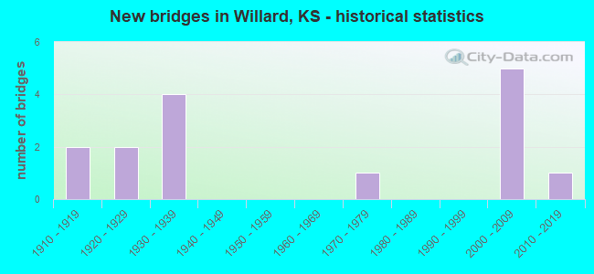
- New bridges - historical statistics
- 21910-1919
- 21920-1929
- 41930-1939
- 11970-1979
- 52000-2009
- 12010-2019
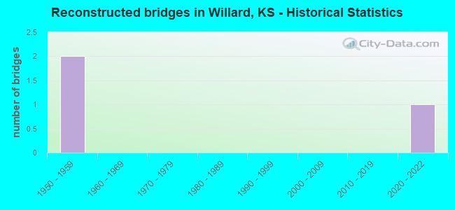
- Reconstructed bridges - Historical Statistics
- 21950-1959
- 01960-1969
- 01970-1979
- 01980-1989
- 01990-1999
- 02000-2009
- 02010-2019
- 12020-2022
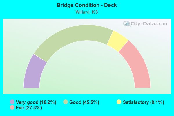
- Bridge Condition - Deck
- 18.2%Very good
- 45.5%Good
- 9.1%Satisfactory
- 27.3%Fair
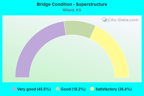
- Bridge Condition - Superstructure
- 45.5%Very good
- 18.2%Good
- 36.4%Satisfactory
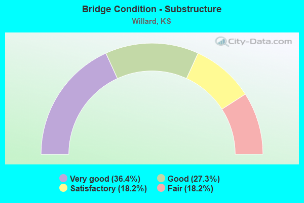
- Bridge Condition - Substructure
- 36.4%Very good
- 27.3%Good
- 18.2%Satisfactory
- 18.2%Fair
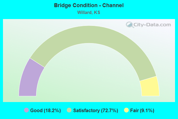
- Bridge Condition - Channel
- 18.2%Good
- 72.7%Satisfactory
- 9.1%Fair
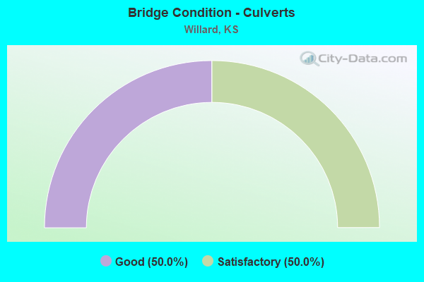
- Bridge Condition - Culverts
- 50.0%Good
- 50.0%Satisfactory
Find on map >> Show street view
Structure Number: 6006, Location: 6.0N OF PAWNEE STATION (Lat: 37.790700, Lng: -94.796667), Route carried "on" structure: County highway 50, Year Built: 1925, Status: Posted for load, Structure Length: 1.16m (3.81ft), Average Daily Traffic: 400 (year 2006), Truck Traffic: 10%, Average Future Daily Traffic: 400 (year 2039), Features Intersected: TRIB. MARMATON RIVER
Minimum Vertical Clearance: 30.47m (99.97ft), Kilometerpoint: 14.971, Lanes on structure: 2, Owner: County Highway Agency, Approaching Roadway Width: 7.8m (25.6ft), Material/Design: Concrete, Design/Construction: Tee Beam, Number Of Spans In Main Unit: 1, Length of Maximum Span: 11.0m (36.1ft), Curb-To-Curb Width: 6.2m (20.3ft), Out-to-Out Width: 7.0m (23.0ft)
Condition: Deck: Good, Superstructure: Good, Substructure: Good, Channel: Satisfactory, Operating Rating: 23.6 metric tons, Method Used To Determine Operating Rating: Field evaluation and documented engineering judgment, Inventory Rating: 23.6 metric tons, Method Used To Determine Inventory Rating: Field evaluation and documented engineering judgment, Structural Evaluation: Equal to present minimum criteria, Deck Geometry: Meets minimum limits, Waterway Adequacy: Equal to present minimum criteria, Approach Roadway Alignment: Equal to present desirable criteria, Bridge Posting: Required (Relationship of Operating Rating to Maximum Legal Load: > 39.9% below), Length Of Structure Improvement: 1.16m (3.81ft), Designated Inspection Frequency: Every 24 months, Inspection Date: March 2020, Other Special Inspection Date: June 2021, Bridge Improvement Cost: $39,000, Roadway Improvement Cost: $4,000, Total Project Cost: $59,000, Deck Structure Type: Concrete Cast-file-Place, Wearing Surface/Protective System: Wearing Surface: Bituminous
Find on map >> Show street view
Structure Number: 89012, Location: 1.0S OF WILLARD (Lat: 39.078861, Lng: -95.946622), Route carried "on" structure: County highway 315, Year Built: 2005, Status: Open, Structure Length: 3.76m (12.34ft), Average Daily Traffic: 2,375 (year 2020), Truck Traffic: 2%, Average Future Daily Traffic: 2,665 (year 2040), Design Load: HS 20, Features Intersected: POST CREEK
Minimum Vertical Clearance: 30.47m (99.97ft), Kilometerpoint: 0.000, Lanes on structure: 2, Owner: County Highway Agency, Approaching Roadway Width: 9.8m (32.2ft), Material/Design: Concrete continuous, Design/Construction: Slab, Number Of Spans In Main Unit: 3, Length of Maximum Span: 14.6m (47.9ft), Curb-To-Curb Width: 9.8m (32.2ft), Out-to-Out Width: 10.4m (34.1ft)
Condition: Deck: Good, Superstructure: Good, Substructure: Very good, Channel: Good, Operating Rating: 87.3 metric tons, Method Used To Determine Operating Rating: Load Factor (LF), Inventory Rating: 49.9 metric tons, Method Used To Determine Inventory Rating: Load Factor (LF), Structural Evaluation: Better than present minimum criteria, Deck Geometry: Meets minimum limits, Waterway Adequacy: Better than present minimum criteria, Approach Roadway Alignment: Equal to present desirable criteria, Designated Inspection Frequency: Every 24 months, Inspection Date: January 2022, Deck Structure Type: Concrete Cast-file-Place, Wearing Surface/Protective System: Wearing Surface: Monolithic Concrete, Deck Protection: Epoxy Coated Reinforcing
Find on map >> Show street view
Structure Number: 890131, Location: 0.2N OF WILLARD (Lat: 39.098700, Lng: -95.946586), Route carried "on" structure: County highway 315, Year Built: 2017, Status: Open, Structure Length: 70.11m (230.02ft), Average Daily Traffic: 2,375 (year 2020), Truck Traffic: 2%, Average Future Daily Traffic: 3,475 (year 2040), Design Load: HL 93, Features Intersected: KANSAS RIVER / CRI&P RR
Minimum Vertical Clearance: 30.47m (99.97ft), Kilometerpoint: 0.000, Lanes on structure: 2, Owner: County Highway Agency, Approaching Roadway Width: 7.3m (24.0ft), Material/Design: Steel continuous, Design/Construction: Stringer/Multi-beam, Number Of Spans In Main Unit: 12, Number Of Approach Spans: 4, Length of Maximum Span: 76.2m (250.0ft), Curb or Sidewalk Widths: Left: 0.0m, Right: 2.4m (7.9ft), Curb-To-Curb Width: 11.0m (36.1ft), Out-to-Out Width: 14.3m (46.9ft)
Condition: Deck: Very good, Superstructure: Very good, Substructure: Very good, Channel: Satisfactory, Operating Rating: 90.7 metric tons, Method Used To Determine Operating Rating: Load Factor (LF), Inventory Rating: 55.3 metric tons, Method Used To Determine Inventory Rating: Load Factor (LF), Structural Evaluation: Equal to present desirable criteria, Deck Geometry: Somewhat better than minimum adequacy, Waterway Adequacy: Equal to present desirable criteria, Approach Roadway Alignment: Equal to present desirable criteria, Designated Inspection Frequency: Every 24 months, Inspection Date: January 2022, Deck Structure Type: Concrete Cast-file-Place, Wearing Surface/Protective System: Wearing Surface: Monolithic Concrete, Deck Protection: Epoxy Coated Reinforcing
Find on map >> Show street view
Structure Number: 890969504247, Location: 0.1S OF WILLARD (Lat: 39.091531, Lng: -95.938836), Route carried "on" structure: County highway , Year Built: 1970, Status: Open, Structure Length: 1.78m (5.84ft), Average Daily Traffic: 200 (year 2022), Average Future Daily Traffic: 200 (year 2040), Features Intersected: POST CREEK, Facility Carried by Structure: DOUGLAS RD. 30
Minimum Vertical Clearance: 30.47m (99.97ft), Kilometerpoint: 0.000, Lanes on structure: 2, Owner: County Highway Agency, Approaching Roadway Width: 8.5m (27.9ft), Skew: 3 degrees, Material/Design: Steel, Design/Construction: Stringer/Multi-beam, Number Of Spans In Main Unit: 1, Length of Maximum Span: 16.2m (53.1ft), Curb-To-Curb Width: 8.0m (26.2ft), Out-to-Out Width: 8.5m (27.9ft)
Condition: Deck: Satisfactory, Superstructure: Satisfactory, Substructure: Satisfactory, Channel: Fair, Operating Rating: 89.1 metric tons, Method Used To Determine Operating Rating: Load Factor (LF), Inventory Rating: 53.5 metric tons, Method Used To Determine Inventory Rating: Load Factor (LF), Structural Evaluation: Equal to present minimum criteria, Deck Geometry: Somewhat better than minimum adequacy, Waterway Adequacy: Equal to present minimum criteria, Approach Roadway Alignment: Better than present minimum criteria, Designated Inspection Frequency: Every 24 months, Inspection Date: January 2022, Deck Structure Type: Concrete Cast-file-Place, Wearing Surface/Protective System: Wearing Surface: Monolithic Concrete
Find on map >> Show street view
Structure Number: 89096980432, Location: 3.5S 0.4E OF WILLARD (Lat: 39.044028, Lng: -95.931397), Route carried "on" structure: County highway , Year Built: 1921, Status: Posted for load, Structure Length: 1.31m (4.30ft), Average Daily Traffic: 50 (year 2022), Average Future Daily Traffic: 50 (year 2040), Features Intersected: VASSAR CREEK, Facility Carried by Structure: S.W. 13TH. ST. 36
Minimum Vertical Clearance: 30.47m (99.97ft), Kilometerpoint: 0.000, Lanes on structure: 2, Owner: County Highway Agency, Approaching Roadway Width: 6.7m (22.0ft), Material/Design: Concrete, Design/Construction: Stringer/Multi-beam, Number Of Spans In Main Unit: 1, Length of Maximum Span: 12.2m (40.0ft), Curb-To-Curb Width: 5.5m (18.0ft), Out-to-Out Width: 6.7m (22.0ft)
Condition: Deck: Fair, Superstructure: Satisfactory, Substructure: Fair, Channel: Satisfactory, Operating Rating: 11.7 metric tons, Method Used To Determine Operating Rating: Load Factor (LF), Inventory Rating: 7.2 metric tons, Method Used To Determine Inventory Rating: Load Factor (LF), Structural Evaluation: High priority of corrective action, Deck Geometry: Meets minimum limits, Waterway Adequacy: Equal to present minimum criteria, Approach Roadway Alignment: Equal to present desirable criteria, Bridge Posting: Required (Relationship of Operating Rating to Maximum Legal Load: > 39.9% below), Designated Inspection Frequency: Every 24 months, Inspection Date: January 2022, Deck Structure Type: Concrete Cast-file-Place, Wearing Surface/Protective System: Wearing Surface: Gravel
Find on map >> Show street view
Structure Number: 890971504303, Location: 2.5S 1.0E OF WILLARD (Lat: 39.053547, Lng: -95.918767), Route carried "on" structure: County highway , Year Built: 1933, Status: Posted for load, Structure Length: 1.07m (3.51ft), Average Daily Traffic: 200 (year 2022), Average Future Daily Traffic: 200 (year 2040), Features Intersected: VASSAR CREEK, Facility Carried by Structure: W. UNION RD. 44
Minimum Vertical Clearance: 30.47m (99.97ft), Kilometerpoint: 0.000, Lanes on structure: 2, Owner: County Highway Agency, Approaching Roadway Width: 6.7m (22.0ft), Material/Design: Steel, Design/Construction: Stringer/Multi-beam, Number Of Spans In Main Unit: 1, Length of Maximum Span: 10.1m (33.1ft), Curb-To-Curb Width: 6.1m (20.0ft), Out-to-Out Width: 6.7m (22.0ft)
Condition: Deck: Fair, Superstructure: Satisfactory, Substructure: Satisfactory, Channel: Satisfactory, Operating Rating: 23.0 metric tons, Method Used To Determine Operating Rating: Load Factor (LF), Inventory Rating: 13.6 metric tons, Method Used To Determine Inventory Rating: Load Factor (LF), Structural Evaluation: Meets minimum limits, Deck Geometry: Meets minimum limits, Waterway Adequacy: Equal to present minimum criteria, Approach Roadway Alignment: Better than present minimum criteria, Bridge Posting: Required (Relationship of Operating Rating to Maximum Legal Load: 10.0 - 19.9% below), Designated Inspection Frequency: Every 24 months, Inspection Date: January 2022, Deck Structure Type: Concrete Cast-file-Place, Wearing Surface/Protective System: Wearing Surface: Gravel
Find on map >> Show street view
Structure Number: 890973104269, Location: 1.5W 0.5S OF VALENCIA (Lat: 39.073069, Lng: -95.907939), Route carried "on" structure: County highway , Year Built: 1917, Status: Open, Structure Length: 1.43m (4.69ft), Average Daily Traffic: 100 (year 2022), Average Future Daily Traffic: 100 (year 2040), Features Intersected: VASSAR CREEK, Facility Carried by Structure: N.W. 13TH. ST. 50
Minimum Vertical Clearance: 30.47m (99.97ft), Kilometerpoint: 0.000, Lanes on structure: 2, Owner: County Highway Agency, Approaching Roadway Width: 5.4m (17.7ft), Material/Design: Concrete, Design/Construction: Culvert, Number Of Spans In Main Unit: 1, Length of Maximum Span: 14.3m (46.9ft), Curb-To-Curb Width: 4.9m (16.1ft), Out-to-Out Width: 5.5m (18.0ft)
Condition: Channel: Satisfactory, Culverts: Satisfactory, Operating Rating: 39.1 metric tons, Method Used To Determine Operating Rating: Load Factor (LF), Inventory Rating: 22.7 metric tons, Method Used To Determine Inventory Rating: Load Factor (LF), Structural Evaluation: Equal to present minimum criteria, Deck Geometry: High priority of corrective action, Waterway Adequacy: Equal to present minimum criteria, Approach Roadway Alignment: Meets minimum limits, Length Of Structure Improvement: 1.52m (4.99ft), Designated Inspection Frequency: Every 24 months, Inspection Date: January 2022, Bridge Improvement Cost: $85,000, Roadway Improvement Cost: $10,000, Total Project Cost: $118,000
Find on map >> Show street view
Structure Number: 890973104285, Location: 2.0S.W. OF VALENCIA (Lat: 39.065700, Lng: -95.907389), Route carried "on" structure: County highway , Year Built: 1916, Status: Open, Structure Length: 1.40m (4.59ft), Average Daily Traffic: 100 (year 2022), Average Future Daily Traffic: 100 (year 2040), Features Intersected: VASSAR CREEK, Facility Carried by Structure: N.W. 4TH. ST. 51
Minimum Vertical Clearance: 30.47m (99.97ft), Kilometerpoint: 0.000, Lanes on structure: 2, Owner: County Highway Agency, Approaching Roadway Width: 6.0m (19.7ft), Material/Design: Concrete, Design/Construction: Culvert, Number Of Spans In Main Unit: 1, Length of Maximum Span: 14.0m (45.9ft), Curb-To-Curb Width: 4.9m (16.1ft), Out-to-Out Width: 5.8m (19.0ft)
Condition: Channel: Satisfactory, Culverts: Satisfactory, Operating Rating: 39.1 metric tons, Method Used To Determine Operating Rating: Load Factor (LF), Inventory Rating: 22.7 metric tons, Method Used To Determine Inventory Rating: Load Factor (LF), Structural Evaluation: Equal to present minimum criteria, Deck Geometry: High priority of corrective action, Waterway Adequacy: Equal to present minimum criteria, Approach Roadway Alignment: Equal to present desirable criteria, Length Of Structure Improvement: 2.58m (8.46ft), Designated Inspection Frequency: Every 24 months, Inspection Date: January 2022, Bridge Improvement Cost: $200,000, Roadway Improvement Cost: $80,000, Total Project Cost: $350,000
Find on map >> Show street view
Structure Number: 990963904241, Location: 2.0E 1.0N OF MAPLE HILL (Lat: 39.100906, Lng: -95.985683), Route carried "on" structure: County highway 9918, Year Built: 1930, Status: Posted for load, Structure Length: 0.84m (2.76ft), Average Daily Traffic: 30 (year 2013), Average Future Daily Traffic: 36 (year 2041), Features Intersected: TRIB. MILL CREEK, Facility Carried by Structure: MINOR COL 26
Minimum Vertical Clearance: 30.47m (99.97ft), Kilometerpoint: 0.000, Lanes on structure: 2, Owner: County Highway Agency, Approaching Roadway Width: 4.8m (15.7ft), Material/Design: Concrete, Design/Construction: Tee Beam, Number Of Spans In Main Unit: 1, Length of Maximum Span: 8.2m (26.9ft), Curb-To-Curb Width: 5.2m (17.1ft), Out-to-Out Width: 6.2m (20.3ft)
Condition: Deck: Fair, Superstructure: Satisfactory, Substructure: Fair, Channel: Satisfactory, Operating Rating: 32.4 metric tons, Method Used To Determine Operating Rating: Allowable Stress (AS), Inventory Rating: 24.3 metric tons, Method Used To Determine Inventory Rating: Allowable Stress (AS), Structural Evaluation: Somewhat better than minimum adequacy, Deck Geometry: High priority of corrective action, Waterway Adequacy: Equal to present minimum criteria, Approach Roadway Alignment: Meets minimum limits, Length Of Structure Improvement: 1.82m (5.97ft), Designated Inspection Frequency: Every 24 months, Inspection Date: November 2021, Bridge Improvement Cost: $160,000, Roadway Improvement Cost: $100,000, Total Project Cost: $270,000 ( Estimate for 2015), Deck Structure Type: Concrete Cast-file-Place
Find on map >> Show street view
Structure Number: 999907000890051, Location: 2.06 MI E WB COLN (Lat: 39.058056, Lng: -95.908333), Route carried "on" structure: Interstate 70, Year Built: 1935, Year Reconstructed: 1956, Status: Open, Structure Length: 1.22m (4.00ft), Average Daily Traffic: 12,309 (year 2020), Truck Traffic: 16%, Average Future Daily Traffic: 17,586 (year 2041), Design Load: H 15, Features Intersected: VASSAR CREEK
Minimum Vertical Clearance: 30.47m (99.97ft), Kilometerpoint: 3.312, Lanes on structure: 4, Base Highway Network: Yes, Owner: State Highway Agency, Approaching Roadway Width: 24.4m (80.1ft), Skew: 20 degrees, Material/Design: Concrete, Design/Construction: Culvert, Number Of Spans In Main Unit: 1, Length of Maximum Span: 12.2m (40.0ft), Curb-To-Curb Width: 24.4m (80.1ft), Out-to-Out Width: 74.5m (244.4ft)
Condition: Channel: Satisfactory, Culverts: Good, Operating Rating: 39.9 metric tons, Method Used To Determine Operating Rating: Load Factor (LF), Inventory Rating: 23.6 metric tons, Method Used To Determine Inventory Rating: Load Factor (LF), Structural Evaluation: Somewhat better than minimum adequacy, Deck Geometry: Superior to present desirable criteria, Waterway Adequacy: Equal to present minimum criteria, Approach Roadway Alignment: Equal to present desirable criteria, Length Of Structure Improvement: 4.20m (13.78ft), Designated Inspection Frequency: Every 24 months, Inspection Date: April 2020, Deck Structure Type: Concrete Cast-file-Place, Wearing Surface/Protective System: Wearing Surface: Bituminous
Find on map >> Show street view
Structure Number: 999907000892731, Location: 0.0 MI E WABAUNSEE COLN (Lat: 39.058056, Lng: -95.946667), Route carried "on" structure: Interstate 70, Year Built: 2002, Status: Open, Structure Length: 6.12m (20.08ft), Average Daily Traffic: 11,022 (year 2020), Truck Traffic: 17%, Average Future Daily Traffic: 15,748 (year 2041), Design Load: HL 93, Features Intersected: ROSSVILLE ROAD
Minimum Vertical Clearance: 30.47m (99.97ft), Kilometerpoint: 0.000, Lanes on structure: 2, Lanes under structure: 2, Base Highway Network: Yes, Owner: State Highway Agency, Approaching Roadway Width: 12.2m (40.0ft), Material/Design: Steel continuous, Design/Construction: Stringer/Multi-beam, Number Of Spans In Main Unit: 3, Length of Maximum Span: 32.5m (106.6ft), Curb-To-Curb Width: 12.2m (40.0ft), Out-to-Out Width: 12.8m (42.0ft)
Condition: Deck: Good, Superstructure: Very good, Substructure: Good, Operating Rating: 58.0 metric tons, Method Used To Determine Operating Rating: Load and Resistance Factor Rating (LRFR) rating reported by rating factor(RF) method using HL-93 loadings, Inventory Rating: 44.7 metric tons, Method Used To Determine Inventory Rating: Load and Resistance Factor Rating (LRFR) rating reported by rating factor(RF) method using HL-93 loadings, Structural Evaluation: Better than present minimum criteria, Deck Geometry: Better than present minimum criteria, Underclear: Superior to present desirable criteria, Approach Roadway Alignment: Equal to present desirable criteria, Length Of Structure Improvement: 20.10m (65.94ft), Designated Inspection Frequency: Every 24 months, Inspection Date: April 2020, Wearing Surface/Protective System: Wearing Surface: Low Slump Concrete, Deck Protection: Epoxy Coated Reinforcing
Find on map >> Show street view
Structure Number: 999907000892741, Location: .01 MI E WABAUNSEE COLN (Lat: 39.058333, Lng: -95.946667), Route carried "on" structure: Interstate 70, Year Built: 2002, Status: Open, Structure Length: 6.12m (20.08ft), Average Daily Traffic: 11,022 (year 2020), Truck Traffic: 17%, Average Future Daily Traffic: 15,748 (year 2041), Design Load: HS 20, Features Intersected: ROSSVILLE ROAD
Minimum Vertical Clearance: 30.47m (99.97ft), Kilometerpoint: 0.000, Lanes on structure: 2, Lanes under structure: 2, Base Highway Network: Yes, Owner: State Highway Agency, Approaching Roadway Width: 12.2m (40.0ft), Material/Design: Steel continuous, Design/Construction: Stringer/Multi-beam, Number Of Spans In Main Unit: 3, Length of Maximum Span: 32.5m (106.6ft), Curb-To-Curb Width: 12.2m (40.0ft), Out-to-Out Width: 12.8m (42.0ft)
Condition: Deck: Good, Superstructure: Very good, Substructure: Good, Operating Rating: 84.4 metric tons, Method Used To Determine Operating Rating: Load Factor (LF), Inventory Rating: 50.8 metric tons, Method Used To Determine Inventory Rating: Load Factor (LF), Structural Evaluation: Better than present minimum criteria, Deck Geometry: Better than present minimum criteria, Underclear: Superior to present desirable criteria, Approach Roadway Alignment: Equal to present desirable criteria, Length Of Structure Improvement: 20.10m (65.94ft), Designated Inspection Frequency: Every 24 months, Inspection Date: April 2020, Wearing Surface/Protective System: Wearing Surface: Low Slump Concrete, Deck Protection: Epoxy Coated Reinforcing
Find on map >> Show street view
Structure Number: 999907000892751, Location: 1.49 MI E WABAUNSEE COLN (Lat: 39.058056, Lng: -95.918611), Route carried "on" structure: Interstate 70, Year Built: 2003, Year Reconstructed: 2020, Status: Open, Structure Length: 5.69m (18.67ft), Average Daily Traffic: 12,309 (year 2020), Truck Traffic: 16%, Average Future Daily Traffic: 17,586 (year 2041), Design Load: HL 93, Features Intersected: WEST UNION ROAD
Minimum Vertical Clearance: 30.47m (99.97ft), Kilometerpoint: 2.408, Lanes on structure: 2, Lanes under structure: 2, Base Highway Network: Yes, Owner: State Highway Agency, Approaching Roadway Width: 12.2m (40.0ft), Material/Design: Prestressed concrete continuous, Design/Construction: Slab, Number Of Spans In Main Unit: 3, Length of Maximum Span: 22.0m (72.2ft), Curb-To-Curb Width: 12.2m (40.0ft), Out-to-Out Width: 12.8m (42.0ft)
Condition: Deck: Very good, Superstructure: Very good, Substructure: Very good, Operating Rating: 68.7 metric tons, Method Used To Determine Operating Rating: Load and Resistance Factor Rating (LRFR) rating reported by rating factor(RF) method using HL-93 loadings, Inventory Rating: 44.4 metric tons, Method Used To Determine Inventory Rating: Load and Resistance Factor Rating (LRFR) rating reported by rating factor(RF) method using HL-93 loadings, Structural Evaluation: Equal to present desirable criteria, Deck Geometry: Better than present minimum criteria, Underclear: Superior to present desirable criteria, Approach Roadway Alignment: Equal to present desirable criteria, Length Of Structure Improvement: 18.67m (61.25ft), Designated Inspection Frequency: Every 24 months, Inspection Date: April 2020, Wearing Surface/Protective System: Wearing Surface: Epoxy Overlay, Deck Protection: Epoxy Coated Reinforcing
Find on map >> Show street view
Structure Number: 999907000892761, Location: 1.50 MI E WABAUNSEE COLN (Lat: 39.058333, Lng: -95.918611), Route carried "on" structure: Interstate 70, Year Built: 2003, Status: Open, Structure Length: 5.58m (18.31ft), Average Daily Traffic: 12,309 (year 2020), Truck Traffic: 16%, Average Future Daily Traffic: 17,586 (year 2041), Design Load: HL 93, Features Intersected: WEST UNION ROAD
Minimum Vertical Clearance: 30.47m (99.97ft), Kilometerpoint: 2.406, Lanes on structure: 3, Lanes under structure: 2, Base Highway Network: Yes, Owner: State Highway Agency, Approaching Roadway Width: 15.3m (50.2ft), Material/Design: Concrete continuous, Design/Construction: Slab, Number Of Spans In Main Unit: 3, Length of Maximum Span: 22.0m (72.2ft), Curb-To-Curb Width: 15.3m (50.2ft), Out-to-Out Width: 15.9m (52.2ft)
Condition: Deck: Good, Superstructure: Very good, Substructure: Very good, Operating Rating: 51.8 metric tons, Method Used To Determine Operating Rating: Load and Resistance Factor Rating (LRFR) rating reported by rating factor(RF) method using HL-93 loadings, Inventory Rating: 39.9 metric tons, Method Used To Determine Inventory Rating: Load and Resistance Factor Rating (LRFR) rating reported by rating factor(RF) method using HL-93 loadings, Structural Evaluation: Equal to present desirable criteria, Deck Geometry: Meets minimum limits, Underclear: Superior to present desirable criteria, Approach Roadway Alignment: Equal to present desirable criteria, Length Of Structure Improvement: 18.29m (60.01ft), Designated Inspection Frequency: Every 24 months, Inspection Date: April 2020, Wearing Surface/Protective System: Wearing Surface: Monolithic Concrete, Deck Protection: Epoxy Coated Reinforcing
Find on map >> Show street view
Structure Number: 999907000990351, Location: 4.39 MI E K30 (Lat: 39.058333, Lng: -95.957500), Route carried "on" structure: Interstate 70, Year Built: 1937, Year Reconstructed: 1957, Status: Open, Structure Length: 1.22m (4.00ft), Average Daily Traffic: 11,022 (year 2020), Truck Traffic: 17%, Average Future Daily Traffic: 15,748 (year 2041), Design Load: H 15, Features Intersected: POST CREEK
Minimum Vertical Clearance: 30.47m (99.97ft), Kilometerpoint: 37.750, Lanes on structure: 4, Base Highway Network: Yes, Owner: State Highway Agency, Approaching Roadway Width: 24.4m (80.1ft), Skew: 20 degrees, Material/Design: Concrete, Design/Construction: Culvert, Number Of Spans In Main Unit: 1, Length of Maximum Span: 12.2m (40.0ft), Curb-To-Curb Width: 24.4m (80.1ft), Out-to-Out Width: 50.9m (167.0ft)
Condition: Channel: Good, Culverts: Good, Operating Rating: 34.5 metric tons, Method Used To Determine Operating Rating: Load Factor (LF), Inventory Rating: 20.9 metric tons, Method Used To Determine Inventory Rating: Load Factor (LF), Structural Evaluation: Somewhat better than minimum adequacy, Deck Geometry: Superior to present desirable criteria, Waterway Adequacy: Better than present minimum criteria, Approach Roadway Alignment: Equal to present desirable criteria, Length Of Structure Improvement: 4.20m (13.78ft), Designated Inspection Frequency: Every 24 months, Inspection Date: April 2020, Deck Structure Type: Concrete Cast-file-Place, Wearing Surface/Protective System: Wearing Surface: Bituminous