Bridge Statistics for Williamsburg, New Mexico (NM)
Condition, Traffic, Stress, Structural Evaluation, Project Costs
- National Bridge Inventory (NBI) Statistics
- 10Number of bridges
- 52ft / 15.7mTotal length
- $1,794,000Total costs
- 47,787Total average daily traffic
- 12,115Total average daily truck traffic
- National Bridge Inventory (NBI) Registered Bridges for Williamsburg
- No street view available for this location
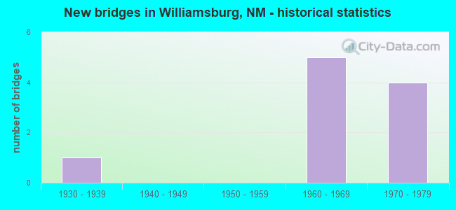
- New bridges - historical statistics
- 11930-1939
- 51960-1969
- 41970-1979


- Bridge Condition - Channel
- 75.0%Satisfactory
- 25.0%Fair
Find on map >> Show street view
Structure Number: 2068, Location: 11.1 MI N OF NM-152 (Lat: 33.102981, Lng: -107.297375), Route carried "on" structure: State highway 187, Year Built: 1933, Status: Open, Structure Length: 1.74m (5.71ft), Average Daily Traffic: 844 (year 2020), Truck Traffic: 21%, Average Future Daily Traffic: 725 (year 2040), Design Load: H 15, Features Intersected: CANADA HONDA
Minimum Vertical Clearance: 30+ m (98+ ft), Kilometerpoint: 57.099, Lanes on structure: 2, Owner: State Highway Agency, Approaching Roadway Width: 8.0m (26.2ft), Material/Design: Concrete continuous, Design/Construction: Culvert, Number Of Spans In Main Unit: 6, Length of Maximum Span: 2.7m (8.9ft)
Condition: Channel: Satisfactory, Culverts: Satisfactory, Operating Rating: 37.3 metric tons, Method Used To Determine Operating Rating: Load Factor (LF), Inventory Rating: 24.3 metric tons, Method Used To Determine Inventory Rating: Load Factor (LF), Structural Evaluation: Equal to present minimum criteria, Waterway Adequacy: Equal to present minimum criteria, Approach Roadway Alignment: Equal to present desirable criteria, Designated Inspection Frequency: Every 24 months, Inspection Date: December 2021
Find on map >> Show street view
Structure Number: 207, Location: 0.7 M N I-25/WILLIAMSBURG (Lat: 33.118758, Lng: -107.287103), Route carried "on" structure: State highway 11, Year Built: 1970, Status: Open, Structure Length: 0.94m (3.08ft), Average Daily Traffic: 8,136 (year 2020), Truck Traffic: 7%, Average Future Daily Traffic: 11,449 (year 2040), Design Load: HS 20, Features Intersected: UNNAMED WATERWAY
Minimum Vertical Clearance: 30+ m (98+ ft), Kilometerpoint: 0.000, Lanes on structure: 4, Base Highway Network: Yes, Owner: State Highway Agency, Approaching Roadway Width: 29.0m (95.1ft), Skew: 20 degrees, Material/Design: Concrete continuous, Design/Construction: Culvert, Number Of Spans In Main Unit: 3, Length of Maximum Span: 3.0m (9.8ft)
Condition: Channel: Fair, Culverts: Satisfactory, Operating Rating: 37.6 metric tons, Method Used To Determine Operating Rating: Load Factor (LF), Inventory Rating: 32.7 metric tons, Method Used To Determine Inventory Rating: Load Factor (LF), Structural Evaluation: Equal to present minimum criteria, Waterway Adequacy: Better than present minimum criteria, Approach Roadway Alignment: Equal to present desirable criteria, Designated Inspection Frequency: Every 24 months, Inspection Date: November 2021
Find on map >> Show street view
Structure Number: 6943, Location: Junction I-25/Loop-11 (Lat: 33.113689, Lng: -107.298628), Route carried "on" structure: City street 11, Year Built: 1968, Status: Open, Structure Length: 8.90m (29.20ft), Average Daily Traffic: 989 (year 2020), Truck Traffic: 7%, Average Future Daily Traffic: 1,391 (year 2040), Design Load: HS 20, Features Intersected: I-25 NB and SB
Minimum Vertical Clearance: 30+ m (98+ ft), Kilometerpoint: 0.282, Lanes on structure: 2, Lanes under structure: 4, Base Highway Network: Yes, Owner: State Highway Agency, Approaching Roadway Width: 9.6m (31.5ft), Skew: 3 degrees, Material/Design: Prestressed concrete, Design/Construction: Stringer/Multi-beam, Number Of Spans In Main Unit: 4, Length of Maximum Span: 25.6m (84.0ft), Curb-To-Curb Width: 9.6m (31.5ft), Out-to-Out Width: 10.4m (34.1ft)
Condition: Deck: Poor, Superstructure: Fair, Substructure: Poor, Operating Rating: 53.9 metric tons, Method Used To Determine Operating Rating: Load Factor (LF), Inventory Rating: 30.7 metric tons, Method Used To Determine Inventory Rating: Load Factor (LF), Structural Evaluation: Meets minimum limits, Deck Geometry: Equal to present minimum criteria, Underclear: Equal to present minimum criteria, Approach Roadway Alignment: Equal to present minimum criteria, Length Of Structure Improvement: 8.90m (29.20ft), Designated Inspection Frequency: Every 24 months, Inspection Date: Febuary 2021, Bridge Improvement Cost: $805,000, Roadway Improvement Cost: $80,000, Total Project Cost: $1,208,000 ( Estimate for 2020), Deck Structure Type: Concrete Cast-file-Place
Find on map >> Show street view
Structure Number: 6992, Location: 0.9 MI S WILLIAMSBURG EXT (Lat: 33.102047, Lng: -107.302781), Route carried "on" structure: Interstate 25, Year Built: 1968, Status: Open, Structure Length: 1.53m (5.02ft), Average Daily Traffic: 7,151 (year 2020), Truck Traffic: 37%, Average Future Daily Traffic: 12,241 (year 2040), Design Load: HS 20, Features Intersected: CANADA HONDA
Minimum Vertical Clearance: 30+ m (98+ ft), Kilometerpoint: 119.461, Lanes on structure: 4, Base Highway Network: Yes, Owner: State Highway Agency, Approaching Roadway Width: 24.5m (80.4ft), Skew: 20 degrees, Material/Design: Concrete continuous, Design/Construction: Culvert, Number Of Spans In Main Unit: 4, Length of Maximum Span: 3.7m (12.1ft)
Condition: Channel: Satisfactory, Culverts: Satisfactory, Operating Rating: 67.0 metric tons, Method Used To Determine Operating Rating: Load Factor (LF), Inventory Rating: 32.7 metric tons, Method Used To Determine Inventory Rating: Load Factor (LF), Structural Evaluation: Equal to present minimum criteria, Waterway Adequacy: Equal to present desirable criteria, Approach Roadway Alignment: Equal to present desirable criteria, Designated Inspection Frequency: Every 24 months, Inspection Date: March 2021
Find on map >> Show street view
Structure Number: 6994, Location: 0.6 MILES COUNTY RD B-79 (Lat: 33.096400, Lng: -107.305100), Route carried "on" structure: Interstate 25, Year Built: 1968, Status: Open, Structure Length: 0.77m (2.53ft), Average Daily Traffic: 7,151 (year 2020), Truck Traffic: 37%, Average Future Daily Traffic: 12,241 (year 2040), Design Load: HS 20, Features Intersected: COUNTY RD-B079
Minimum Vertical Clearance: 30+ m (98+ ft), Kilometerpoint: 118.786, Lanes on structure: 4, Lanes under structure: 2, Base Highway Network: Yes, Owner: State Highway Agency, Approaching Roadway Width: 24.7m (81.0ft), Skew: 20 degrees, Material/Design: Concrete, Design/Construction: Culvert, Number Of Spans In Main Unit: 1, Length of Maximum Span: 7.7m (25.3ft)
Condition: Culverts: Satisfactory, Operating Rating: 68.6 metric tons, Method Used To Determine Operating Rating: Load Factor (LF), Inventory Rating: 32.7 metric tons, Method Used To Determine Inventory Rating: Load Factor (LF), Structural Evaluation: Equal to present minimum criteria, Underclear: High priority of corrective action, Approach Roadway Alignment: Equal to present desirable criteria, Length Of Structure Improvement: 0.85m (2.79ft), Designated Inspection Frequency: Every 24 months, Inspection Date: July 2021, Bridge Improvement Cost: $206,000, Roadway Improvement Cost: $21,000, Total Project Cost: $309,000 ( Estimate for 2030)
Find on map >> Show street view
Structure Number: 7201, Location: 0.3 MI N WILLIAMSBURG (Lat: 33.118867, Lng: -107.297556), Route carried "on" structure: Interstate 25, Year Built: 1970, Status: Open, Structure Length: 0.77m (2.53ft), Average Daily Traffic: 7,269 (year 2020), Truck Traffic: 37%, Average Future Daily Traffic: 12,443 (year 2040), Design Load: HS 20, Features Intersected: LOCAL ROAD/1ST STREET
Minimum Vertical Clearance: 30+ m (98+ ft), Kilometerpoint: 121.393, Lanes on structure: 4, Lanes under structure: 2, Base Highway Network: Yes, Owner: State Highway Agency, Approaching Roadway Width: 24.7m (81.0ft), Skew: 20 degrees, Material/Design: Concrete, Design/Construction: Culvert, Number Of Spans In Main Unit: 1, Length of Maximum Span: 7.7m (25.3ft), Curb or Sidewalk Widths: Left: 0.5m (1.6ft), Right: 0.5m (1.6ft)
Condition: Culverts: Satisfactory, Operating Rating: 65.3 metric tons, Method Used To Determine Operating Rating: Load Factor (LF), Inventory Rating: 32.7 metric tons, Method Used To Determine Inventory Rating: Load Factor (LF), Structural Evaluation: Equal to present minimum criteria, Underclear: High priority of corrective action, Approach Roadway Alignment: Equal to present minimum criteria, Length Of Structure Improvement: 0.85m (2.79ft), Designated Inspection Frequency: Every 24 months, Inspection Date: July 2021, Bridge Improvement Cost: $185,000, Roadway Improvement Cost: $18,000, Total Project Cost: $277,000 ( Estimate for 2030)
Find on map >> Show street view
Structure Number: 721, Location: 0.5 M N I-25/WILLIAMSBURG (Lat: 33.117025, Lng: -107.291003), Route carried "on" structure: State highway 11, Year Built: 1970, Status: Open, Structure Length: 1.02m (3.35ft), Average Daily Traffic: 8,136 (year 2020), Truck Traffic: 7%, Average Future Daily Traffic: 11,449 (year 2040), Design Load: HS 20, Features Intersected: UNNAMED WATERWAY
Minimum Vertical Clearance: 30+ m (98+ ft), Kilometerpoint: 1.078, Lanes on structure: 4, Base Highway Network: Yes, Owner: State Highway Agency, Approaching Roadway Width: 28.3m (92.8ft), Skew: 20 degrees, Material/Design: Concrete continuous, Design/Construction: Culvert, Number Of Spans In Main Unit: 4, Length of Maximum Span: 2.4m (7.9ft)
Condition: Channel: Satisfactory, Culverts: Satisfactory, Operating Rating: 37.6 metric tons, Method Used To Determine Operating Rating: Load Factor (LF), Inventory Rating: 32.7 metric tons, Method Used To Determine Inventory Rating: Load Factor (LF), Structural Evaluation: Equal to present minimum criteria, Waterway Adequacy: Equal to present desirable criteria, Approach Roadway Alignment: Equal to present desirable criteria, Designated Inspection Frequency: Every 24 months, Inspection Date: November 2021
Find on map >> Show street view
Structure Number: 6943, Location: Junction I-25/Loop-11 (Lat: 33.113689, Lng: -107.298628), Route carried "under" structure: Interstate 25, Year Built: 1968, Structure Length: 0. m, Average Daily Traffic: 7,269 (year 2020), Truck Traffic: 37%, Features Intersected: I-25 NB and SB, Facility Carried by Structure: L-00011
Minimum Vertical Clearance: 5.09m (16.70ft), Kilometerpoint: 120.813, Lanes on structure: 2, Lanes under structure: 4, Material/Design: Prestressed concrete, Design/Construction: Stringer/Multi-beam, Length of Maximum Span: 25.6m (84.0ft)
Find on map >> Show street view
Structure Number: 6994, Location: 0.6 MILES COUNTY RD B-79 (Lat: 33.096400, Lng: -107.305100), Route carried "under" structure: County highway 51074, Year Built: 1968, Structure Length: 0. m, Average Daily Traffic: 61 (year 2020), Truck Traffic: 16%, Features Intersected: COUNTY RD-B079, Facility Carried by Structure: I-25 NBL/SBL
Minimum Vertical Clearance: 4.24m (13.91ft), Kilometerpoint: 0.000, Lanes on structure: 4, Lanes under structure: 2, Material/Design: Concrete, Design/Construction: Culvert, Length of Maximum Span: 7.7m (25.3ft)
Find on map >> Show street view
Structure Number: 7201, Location: 0.3 MI N WILLIAMSBURG (Lat: 33.118867, Lng: -107.297556), Route carried "under" structure: State highway 51004, Year Built: 1970, Structure Length: 0. m, Average Daily Traffic: 781 (year 2020), Truck Traffic: 7%, Features Intersected: LOCAL ROAD/1ST STREET, Facility Carried by Structure: I-25 NBL/SBL
Minimum Vertical Clearance: 4.22m (13.85ft), Kilometerpoint: 0.000, Lanes on structure: 4, Lanes under structure: 2, Material/Design: Concrete, Design/Construction: Culvert, Length of Maximum Span: 7.7m (25.3ft)