Bridge Statistics for Williamston, Michigan (MI)
Condition, Traffic, Stress, Structural Evaluation, Project Costs
- National Bridge Inventory (NBI) Statistics
- 24Number of bridges
- 154ft / 47.2mTotal length
- $1,506,000Total costs
- 265,607Total average daily traffic
- 26,752Total average daily truck traffic
- National Bridge Inventory (NBI) Registered Bridges for Williamston
- No street view available for this location
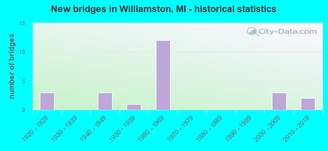
- New bridges - historical statistics
- 31920-1929
- 31940-1949
- 11950-1959
- 121960-1969
- 32000-2009
- 22010-2019
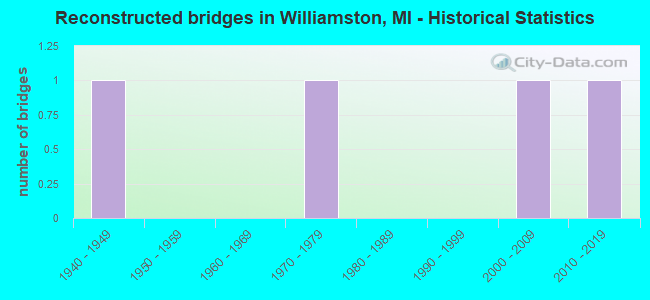
- Reconstructed bridges - Historical Statistics
- 11940-1949
- 01950-1959
- 01960-1969
- 11970-1979
- 01980-1989
- 01990-1999
- 12000-2009
- 12010-2019
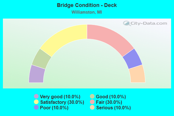
- Bridge Condition - Deck
- 10.0%Very good
- 10.0%Good
- 30.0%Satisfactory
- 30.0%Fair
- 10.0%Poor
- 10.0%Serious
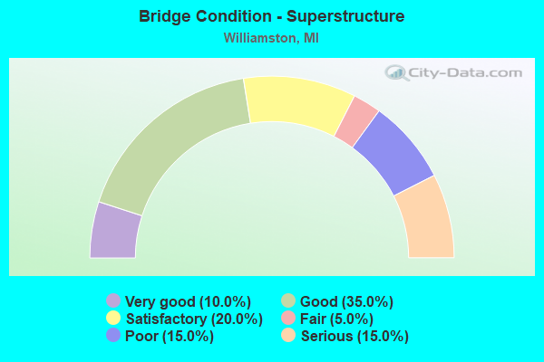
- Bridge Condition - Superstructure
- 10.0%Very good
- 35.0%Good
- 20.0%Satisfactory
- 5.0%Fair
- 15.0%Poor
- 15.0%Serious
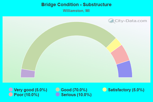
- Bridge Condition - Substructure
- 5.0%Very good
- 70.0%Good
- 5.0%Satisfactory
- 10.0%Poor
- 10.0%Serious
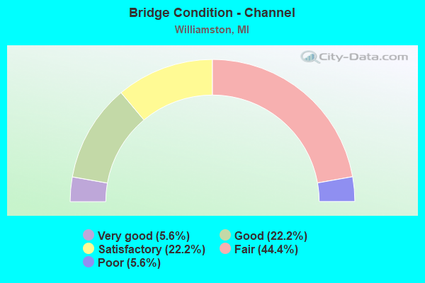
- Bridge Condition - Channel
- 5.6%Very good
- 22.2%Good
- 22.2%Satisfactory
- 44.4%Fair
- 5.6%Poor
Find on map >> Show street view
Structure Number: 3798, Location: IN WILLIAMSTON (Lat: 42.687839, Lng: -84.290225), Route carried "on" structure: State highway 43, Year Built: 2001, Status: Open, Structure Length: 1.04m (3.41ft), Average Daily Traffic: 12,042 (year 2007), Truck Traffic: 3%, Average Future Daily Traffic: 11,693 (year 2018), Design Load: HS 25 or greater, Features Intersected: DEER CREEK
Minimum Vertical Clearance: 30.48m (100.00ft), Kilometerpoint: 23.394, Lanes on structure: 4, Base Highway Network: Yes (Inventory Route: 33, Subroute: 1), Owner: State Highway Agency, Approaching Roadway Width: 14.3m (46.9ft), Material/Design: Prestressed concrete, Design/Construction: Box Beam or Girders - Single/Spread, Number Of Spans In Main Unit: 1, Length of Maximum Span: 10.4m (34.1ft), Curb-To-Curb Width: 19.2m (63.0ft), Out-to-Out Width: 19.8m (65.0ft)
Condition: Deck: Satisfactory, Superstructure: Satisfactory, Substructure: Good, Channel: Good, Operating Rating: 97.6 metric tons, Method Used To Determine Operating Rating: Load Factor (LF), Inventory Rating: 70.2 metric tons, Method Used To Determine Inventory Rating: Load Factor (LF), Structural Evaluation: Equal to present minimum criteria, Deck Geometry: Equal to present minimum criteria, Waterway Adequacy: Equal to present desirable criteria, Approach Roadway Alignment: Equal to present desirable criteria, Designated Inspection Frequency: Every 24 months, Inspection Date: August 2020, Deck Structure Type: Concrete Cast-file-Place, Wearing Surface/Protective System: Wearing Surface: Monolithic Concrete, Deck Protection: Epoxy Coated Reinforcing
Find on map >> Show street view
Structure Number: 3799, Location: 2.2 MI E OF WILLIAMSTON (Lat: 42.680650, Lng: -84.241186), Route carried "on" structure: State highway 43, Year Built: 2000, Status: Open, Structure Length: 1.92m (6.30ft), Average Daily Traffic: 5,289 (year 2007), Truck Traffic: 6%, Average Future Daily Traffic: 6,375 (year 2018), Design Load: HS 25 or greater, Features Intersected: DOAN CREEK
Minimum Vertical Clearance: 30.48m (100.00ft), Kilometerpoint: 27.563, Lanes on structure: 2, Base Highway Network: Yes (Inventory Route: 33, Subroute: 1), Owner: State Highway Agency, Approaching Roadway Width: 14.0m (45.9ft), Material/Design: Prestressed concrete, Design/Construction: Box Beam or Girders - Multiple, Number Of Spans In Main Unit: 1, Length of Maximum Span: 18.4m (60.4ft), Curb-To-Curb Width: 13.4m (44.0ft), Out-to-Out Width: 14.6m (47.9ft)
Condition: Deck: Fair, Superstructure: Good, Substructure: Good, Channel: Satisfactory, Operating Rating: 82.7 metric tons, Method Used To Determine Operating Rating: Load Factor (LF), Inventory Rating: 50.2 metric tons, Method Used To Determine Inventory Rating: Load Factor (LF), Structural Evaluation: Better than present minimum criteria, Deck Geometry: Equal to present minimum criteria, Waterway Adequacy: Equal to present desirable criteria, Approach Roadway Alignment: Better than present minimum criteria, Designated Inspection Frequency: Every 24 months, Inspection Date: August 2020, Deck Structure Type: Concrete Cast-file-Place, Wearing Surface/Protective System: Wearing Surface: Monolithic Concrete, Deck Protection: Epoxy Coated Reinforcing
Find on map >> Show street view
Structure Number: 3812, Location: 0.4 MI W / WILLIAMSTON RD (Lat: 42.665378, Lng: -84.289583), Route carried "on" structure: Interstate 96, Year Built: 1962, Status: Open, Structure Length: 1.37m (4.49ft), Average Daily Traffic: 23,287 (year 2007), Truck Traffic: 11%, Average Future Daily Traffic: 31,680 (year 2018), Design Load: HS 20+Mod, Features Intersected: DEER CREEK
Minimum Vertical Clearance: 30.48m (100.00ft), Kilometerpoint: 26.393, Lanes on structure: 2, Base Highway Network: Yes (Inventory Route: 33, Subroute: 4), Owner: State Highway Agency, Approaching Roadway Width: 13.1m (43.0ft), Skew: 2 degrees, Material/Design: Prestressed concrete, Design/Construction: Stringer/Multi-beam, Number Of Spans In Main Unit: 1, Length of Maximum Span: 13.0m (42.7ft), Curb-To-Curb Width: 11.7m (38.4ft), Out-to-Out Width: 13.3m (43.6ft)
Condition: Deck: Poor, Superstructure: Good, Substructure: Good, Channel: Fair, Operating Rating: 75.3 metric tons, Method Used To Determine Operating Rating: Load Factor (LF), Inventory Rating: 45.1 metric tons, Method Used To Determine Inventory Rating: Load Factor (LF), Structural Evaluation: Better than present minimum criteria, Deck Geometry: Equal to present minimum criteria, Waterway Adequacy: Equal to present desirable criteria, Approach Roadway Alignment: Equal to present desirable criteria, Designated Inspection Frequency: Every 12 months, Inspection Date: May 2021, Deck Structure Type: Concrete Cast-file-Place, Wearing Surface/Protective System: Wearing Surface: Epoxy Overlay
Find on map >> Show street view
Structure Number: 3813, Location: 0.4 MI W / WILLIAMSTON RD (Lat: 42.665917, Lng: -84.289839), Route carried "on" structure: Interstate 96, Year Built: 1962, Status: Open, Structure Length: 1.37m (4.49ft), Average Daily Traffic: 23,287 (year 2007), Truck Traffic: 11%, Average Future Daily Traffic: 31,680 (year 2018), Design Load: HS 20+Mod, Features Intersected: DEER CREEK
Minimum Vertical Clearance: 30.48m (100.00ft), Kilometerpoint: 26.393, Lanes on structure: 2, Base Highway Network: Yes (Inventory Route: 33, Subroute: 10), Owner: State Highway Agency, Approaching Roadway Width: 13.1m (43.0ft), Skew: 2 degrees, Material/Design: Prestressed concrete, Design/Construction: Stringer/Multi-beam, Number Of Spans In Main Unit: 1, Length of Maximum Span: 13.0m (42.7ft), Curb-To-Curb Width: 11.7m (38.4ft), Out-to-Out Width: 13.3m (43.6ft)
Condition: Deck: Fair, Superstructure: Good, Substructure: Good, Channel: Fair, Operating Rating: 74.9 metric tons, Method Used To Determine Operating Rating: Load Factor (LF), Inventory Rating: 44.9 metric tons, Method Used To Determine Inventory Rating: Load Factor (LF), Structural Evaluation: Better than present minimum criteria, Deck Geometry: Equal to present minimum criteria, Waterway Adequacy: Equal to present desirable criteria, Approach Roadway Alignment: Equal to present desirable criteria, Designated Inspection Frequency: Every 16 months, Inspection Date: May 2021, Deck Structure Type: Concrete Cast-file-Place, Wearing Surface/Protective System: Wearing Surface: Epoxy Overlay
Find on map >> Show street view
Structure Number: 3814, Location: 1 MI W OF DIETZ ROAD (Lat: 42.666067, Lng: -84.245894), Route carried "on" structure: Interstate 96, Year Built: 1961, Status: Open, Structure Length: 1.83m (6.00ft), Average Daily Traffic: 21,800 (year 2007), Truck Traffic: 11%, Average Future Daily Traffic: 30,803 (year 2018), Design Load: HS 20+Mod, Features Intersected: DOAN CREEK
Minimum Vertical Clearance: 30.48m (100.00ft), Kilometerpoint: 29.975, Lanes on structure: 2, Base Highway Network: Yes (Inventory Route: 33, Subroute: 4), Owner: State Highway Agency, Approaching Roadway Width: 13.1m (43.0ft), Material/Design: Prestressed concrete, Design/Construction: Stringer/Multi-beam, Number Of Spans In Main Unit: 1, Length of Maximum Span: 17.6m (57.7ft), Curb-To-Curb Width: 11.7m (38.4ft), Out-to-Out Width: 13.3m (43.6ft)
Condition: Deck: Fair, Superstructure: Good, Substructure: Good, Channel: Satisfactory, Operating Rating: 84.0 metric tons, Method Used To Determine Operating Rating: Load Factor (LF), Inventory Rating: 50.3 metric tons, Method Used To Determine Inventory Rating: Load Factor (LF), Structural Evaluation: Better than present minimum criteria, Deck Geometry: Equal to present minimum criteria, Waterway Adequacy: Equal to present desirable criteria, Approach Roadway Alignment: Equal to present desirable criteria, Designated Inspection Frequency: Every 24 months, Inspection Date: September 2020, Deck Structure Type: Concrete Cast-file-Place, Wearing Surface/Protective System: Wearing Surface: Epoxy Overlay
Find on map >> Show street view
Structure Number: 3815, Location: 1 MI W OF DIETZ ROAD (Lat: 42.666528, Lng: -84.245903), Route carried "on" structure: Interstate 96, Year Built: 1961, Status: Open, Structure Length: 1.83m (6.00ft), Average Daily Traffic: 21,800 (year 2007), Truck Traffic: 11%, Average Future Daily Traffic: 30,803 (year 2018), Design Load: HS 20+Mod, Features Intersected: DOAN CREEK
Minimum Vertical Clearance: 30.48m (100.00ft), Kilometerpoint: 29.998, Lanes on structure: 2, Base Highway Network: Yes (Inventory Route: 33, Subroute: 10), Owner: State Highway Agency, Approaching Roadway Width: 13.1m (43.0ft), Material/Design: Prestressed concrete, Design/Construction: Stringer/Multi-beam, Number Of Spans In Main Unit: 1, Length of Maximum Span: 17.6m (57.7ft), Curb-To-Curb Width: 11.7m (38.4ft), Out-to-Out Width: 13.3m (43.6ft)
Condition: Deck: Fair, Superstructure: Good, Substructure: Good, Channel: Satisfactory, Operating Rating: 73.6 metric tons, Method Used To Determine Operating Rating: Load Factor (LF), Inventory Rating: 44.1 metric tons, Method Used To Determine Inventory Rating: Load Factor (LF), Structural Evaluation: Better than present minimum criteria, Deck Geometry: Equal to present minimum criteria, Waterway Adequacy: Equal to present desirable criteria, Approach Roadway Alignment: Equal to present desirable criteria, Designated Inspection Frequency: Every 24 months, Inspection Date: September 2020, Deck Structure Type: Concrete Cast-file-Place, Wearing Surface/Protective System: Wearing Surface: Epoxy Overlay
Find on map >> Show street view
Structure Number: 383, Location: 6.5 MI W OF M-43 & M-52 (Lat: 42.665656, Lng: -84.311694), Route carried "on" structure: County highway , Year Built: 1962, Status: Open, Structure Length: 4.09m (13.42ft), Average Daily Traffic: 3,225 (year 2018), Truck Traffic: 1%, Average Future Daily Traffic: 3,709 (year 2038), Design Load: H 15, Features Intersected: I-96 EB, Facility Carried by Structure: ZIMMER RD
Minimum Vertical Clearance: 30.48m (100.00ft), Kilometerpoint: 5.916, Lanes on structure: 2, Lanes under structure: 2, Owner: State Highway Agency, Approaching Roadway Width: 10.6m (34.8ft), Material/Design: Prestressed concrete, Design/Construction: Stringer/Multi-beam, Number Of Spans In Main Unit: 3, Length of Maximum Span: 17.4m (57.1ft), Curb-To-Curb Width: 8.5m (27.9ft), Out-to-Out Width: 9.4m (30.8ft)
Condition: Deck: Satisfactory, Superstructure: Satisfactory, Substructure: Good, Operating Rating: 66.4 metric tons, Method Used To Determine Operating Rating: Load Factor (LF) rating reported by rating factor (RF) method using MS18 loading, Inventory Rating: 39.9 metric tons, Method Used To Determine Inventory Rating: Load Factor (LF) rating reported by rating factor (RF) method using MS18 loading, Structural Evaluation: Equal to present minimum criteria, Deck Geometry: Meets minimum limits, Underclear: High priority of corrective action, Approach Roadway Alignment: Equal to present desirable criteria, Designated Inspection Frequency: Every 24 months, Inspection Date: September 2020, Deck Structure Type: Concrete Cast-file-Place, Wearing Surface/Protective System: Wearing Surface: Epoxy Overlay
Find on map >> Show street view
Structure Number: 3831, Location: 6.5 MI W OF M-43 & M-52 (Lat: 42.666214, Lng: -84.311722), Route carried "on" structure: County highway , Year Built: 1962, Status: Open, Structure Length: 4.05m (13.29ft), Average Daily Traffic: 3,225 (year 2018), Truck Traffic: 1%, Average Future Daily Traffic: 3,709 (year 2038), Design Load: H 15, Features Intersected: I-96 WB, Facility Carried by Structure: ZIMMER RD
Minimum Vertical Clearance: 30.48m (100.00ft), Kilometerpoint: 5.977, Lanes on structure: 2, Lanes under structure: 2, Owner: State Highway Agency, Approaching Roadway Width: 10.6m (34.8ft), Material/Design: Prestressed concrete, Design/Construction: Stringer/Multi-beam, Number Of Spans In Main Unit: 3, Length of Maximum Span: 17.4m (57.1ft), Curb-To-Curb Width: 8.5m (27.9ft), Out-to-Out Width: 9.4m (30.8ft)
Condition: Deck: Satisfactory, Superstructure: Satisfactory, Substructure: Good, Operating Rating: 66.7 metric tons, Method Used To Determine Operating Rating: Load Factor (LF) rating reported by rating factor (RF) method using MS18 loading, Inventory Rating: 39.9 metric tons, Method Used To Determine Inventory Rating: Load Factor (LF) rating reported by rating factor (RF) method using MS18 loading, Structural Evaluation: Equal to present minimum criteria, Deck Geometry: Meets minimum limits, Underclear: Meets minimum limits, Approach Roadway Alignment: Equal to present desirable criteria, Designated Inspection Frequency: Every 24 months, Inspection Date: September 2020, Deck Structure Type: Concrete Cast-file-Place, Wearing Surface/Protective System: Wearing Surface: Epoxy Overlay
Find on map >> Show street view
Structure Number: 3832, Location: 4.4 MI W OF M-43 & M-52 (Lat: 42.665264, Lng: -84.282108), Route carried "on" structure: County highway 3357, Year Built: 1962, Status: Open, Structure Length: 10.38m (34.06ft), Average Daily Traffic: 3,375 (year 2018), Truck Traffic: 1%, Average Future Daily Traffic: 3,881 (year 2038), Design Load: H 15, Features Intersected: I-96, Facility Carried by Structure: WILLIAMSTON RD
Minimum Vertical Clearance: 30.48m (100.00ft), Kilometerpoint: 7.133, Lanes on structure: 2, Lanes under structure: 6, Owner: State Highway Agency, Approaching Roadway Width: 11.8m (38.7ft), Material/Design: Prestressed concrete, Design/Construction: Stringer/Multi-beam, Number Of Spans In Main Unit: 6, Length of Maximum Span: 20.5m (67.3ft), Curb-To-Curb Width: 9.8m (32.2ft), Out-to-Out Width: 10.6m (34.8ft)
Condition: Deck: Satisfactory, Superstructure: Satisfactory, Substructure: Good, Operating Rating: 56.1 metric tons, Method Used To Determine Operating Rating: Load Factor (LF) rating reported by rating factor (RF) method using MS18 loading, Inventory Rating: 33.4 metric tons, Method Used To Determine Inventory Rating: Load Factor (LF) rating reported by rating factor (RF) method using MS18 loading, Structural Evaluation: Equal to present minimum criteria, Deck Geometry: Meets minimum limits, Underclear: Somewhat better than minimum adequacy, Approach Roadway Alignment: Equal to present desirable criteria, Length Of Structure Improvement: 10.40m (34.12ft), Designated Inspection Frequency: Every 9 months, Inspection Date: December 2021, Bridge Improvement Cost: $44,000, Roadway Improvement Cost: $4,000, Total Project Cost: $51,000, Deck Structure Type: Concrete Cast-file-Place, Wearing Surface/Protective System: Wearing Surface: Latex Concrete, Deck Protection: Epoxy Coated Reinforcing
Find on map >> Show street view
Structure Number: 3868, Location: 3 MILES S OF WILLIAMSTON (Lat: 42.644381, Lng: -84.294664), Route carried "on" structure: County highway , Year Built: 1920, Year Reconstructed: 2013, Status: Open, Structure Length: 0.85m (2.79ft), Average Daily Traffic: 1,192 (year 2013), Average Future Daily Traffic: 1,455 (year 2033), Design Load: H 20, Features Intersected: DEER CREEK, Facility Carried by Structure: HOLT ROAD
Minimum Vertical Clearance: 30.48m (100.00ft), Kilometerpoint: 5.670, Lanes on structure: 2, Owner: County Highway Agency, Approaching Roadway Width: 7.9m (25.9ft), Material/Design: Steel, Design/Construction: Stringer/Multi-beam, Number Of Spans In Main Unit: 1, Length of Maximum Span: 8.0m (26.2ft), Curb-To-Curb Width: 9.8m (32.2ft), Out-to-Out Width: 10.4m (34.1ft)
Condition: Deck: Very good, Superstructure: Very good, Substructure: Good, Channel: Fair, Operating Rating: 97.2 metric tons, Method Used To Determine Operating Rating: Load Factor (LF) rating reported by rating factor (RF) method using MS18 loading, Inventory Rating: 74.5 metric tons, Method Used To Determine Inventory Rating: Load Factor (LF) rating reported by rating factor (RF) method using MS18 loading, Structural Evaluation: Better than present minimum criteria, Deck Geometry: Somewhat better than minimum adequacy, Waterway Adequacy: Equal to present desirable criteria, Approach Roadway Alignment: Equal to present desirable criteria, Designated Inspection Frequency: Every 24 months, Inspection Date: October 2021, Deck Structure Type: Concrete Cast-file-Place, Wearing Surface/Protective System: Wearing Surface: Monolithic Concrete, Deck Protection: Epoxy Coated Reinforcing
Find on map >> Show street view
Structure Number: 3869, Location: 4.6 MILES SE OF WILLIAMST (Lat: 42.644631, Lng: -84.251964), Route carried "on" structure: County highway , Year Built: 1957, Status: Posted for load, Structure Length: 1.40m (4.59ft), Average Daily Traffic: 1,050 (year 2019), Average Future Daily Traffic: 1,250 (year 2039), Design Load: HS 20, Features Intersected: DOAN CREEK, Facility Carried by Structure: HOLT ROAD
Minimum Vertical Clearance: 30.48m (100.00ft), Kilometerpoint: 9.170, Lanes on structure: 2, Owner: County Highway Agency, Approaching Roadway Width: 11.0m (36.1ft), Material/Design: Prestressed concrete, Design/Construction: Box Beam or Girders - Multiple, Number Of Spans In Main Unit: 1, Length of Maximum Span: 14.0m (45.9ft), Curb or Sidewalk Widths: Left: 0.4m (1.3ft), Right: 0.4m (1.3ft), Curb-To-Curb Width: 7.3m (24.0ft), Out-to-Out Width: 9.4m (30.8ft)
Condition: Deck: Fair, Superstructure: Poor, Substructure: Good, Channel: Fair, Operating Rating: 36.0 metric tons, Method Used To Determine Operating Rating: Load Factor (LF) rating reported by rating factor (RF) method using MS18 loading, Inventory Rating: 21.4 metric tons, Method Used To Determine Inventory Rating: Load Factor (LF) rating reported by rating factor (RF) method using MS18 loading, Structural Evaluation: Meets minimum limits, Deck Geometry: Meets minimum limits, Waterway Adequacy: Equal to present desirable criteria, Approach Roadway Alignment: Equal to present desirable criteria, Bridge Posting: Required (Relationship of Operating Rating to Maximum Legal Load: 20.0 - 29.9% below), Length Of Structure Improvement: 1.40m (4.59ft), Designated Inspection Frequency: Every 12 months, Inspection Date: June 2021, Bridge Improvement Cost: $68,000, Roadway Improvement Cost: $24,000, Total Project Cost: $92,000, Deck Structure Type: Concrete Precast Panels, Wearing Surface/Protective System: Wearing Surface: Bituminous
Find on map >> Show street view
Structure Number: 3887, Location: 1.5 MI SW OF WILLIAMSTON (Lat: 42.673211, Lng: -84.291817), Route carried "on" structure: County highway , Year Built: 1968, Status: Posted for load, Structure Length: 1.64m (5.38ft), Average Daily Traffic: 2,465 (year 2019), Average Future Daily Traffic: 3,010 (year 2039), Design Load: H 20, Features Intersected: DEER CREEK, Facility Carried by Structure: LINN ROAD
Minimum Vertical Clearance: 30.48m (100.00ft), Kilometerpoint: 5.884, Lanes on structure: 2, Owner: County Highway Agency, Approaching Roadway Width: 9.8m (32.2ft), Material/Design: Prestressed concrete, Design/Construction: Box Beam or Girders - Multiple, Number Of Spans In Main Unit: 1, Length of Maximum Span: 16.4m (53.8ft), Curb or Sidewalk Widths: Left: 0.2m (0.7ft), Right: 0.2m (0.7ft), Curb-To-Curb Width: 9.1m (29.9ft), Out-to-Out Width: 10.3m (33.8ft)
Condition: Deck: Serious, Superstructure: Serious, Substructure: Good, Channel: Satisfactory, Operating Rating: 42.4 metric tons, Method Used To Determine Operating Rating: Load Factor (LF) rating reported by rating factor (RF) method using MS18 loading, Inventory Rating: 25.6 metric tons, Method Used To Determine Inventory Rating: Load Factor (LF) rating reported by rating factor (RF) method using MS18 loading, Structural Evaluation: High priority of corrective action, Deck Geometry: Meets minimum limits, Waterway Adequacy: Equal to present desirable criteria, Approach Roadway Alignment: Equal to present desirable criteria, Bridge Posting: Required (Relationship of Operating Rating to Maximum Legal Load: 10.0 - 19.9% below), Length Of Structure Improvement: 1.65m (5.41ft), Designated Inspection Frequency: Every 12 months, Inspection Date: June 2021, Bridge Improvement Cost: $120,000, Roadway Improvement Cost: $24,000, Total Project Cost: $144,000, Deck Structure Type: Concrete Precast Panels, Wearing Surface/Protective System: Wearing Surface: Bituminous
Find on map >> Show street view
Structure Number: 3899, Location: 2.9 MI SE OF WILLIAMSTON (Lat: 42.659428, Lng: -84.245011), Route carried "on" structure: County highway , Year Built: 2014, Status: Open, Structure Length: 1.04m (3.41ft), Average Daily Traffic: 535 (year 2013), Truck Traffic: 1%, Average Future Daily Traffic: 1,000 (year 2033), Design Load: Greater than HL93, Features Intersected: DOAN CREEK, Facility Carried by Structure: NOBLE ROAD
Minimum Vertical Clearance: 30.48m (100.00ft), Kilometerpoint: 9.732, Lanes on structure: 2, Owner: County Highway Agency, Approaching Roadway Width: 9.1m (29.9ft), Material/Design: Concrete, Design/Construction: Culvert, Number Of Spans In Main Unit: 1, Length of Maximum Span: 9.8m (32.2ft), Curb-To-Curb Width: 9.1m (29.9ft), Out-to-Out Width: 20.1m (65.9ft)
Condition: Channel: Good, Culverts: Very good, Operating Rating: 63.2 metric tons, Method Used To Determine Operating Rating: Load and Resistance Factor Rating (LRFR) rating reported by rating factor(RF) method using HL-93 loadings, Inventory Rating: 48.9 metric tons, Method Used To Determine Inventory Rating: Load and Resistance Factor Rating (LRFR) rating reported by rating factor(RF) method using HL-93 loadings, Structural Evaluation: Equal to present desirable criteria, Deck Geometry: Equal to present minimum criteria, Waterway Adequacy: Equal to present minimum criteria, Approach Roadway Alignment: Equal to present desirable criteria, Designated Inspection Frequency: Every 24 months, Inspection Date: July 2020
Find on map >> Show street view
Structure Number: 39, Location: 2.3 MI SE OF WILLIAMSTON (Lat: 42.674097, Lng: -84.244017), Route carried "on" structure: County highway , Year Built: 1964, Status: Open, Structure Length: 0.82m (2.69ft), Average Daily Traffic: 300 (year 2019), Average Future Daily Traffic: 370 (year 2039), Design Load: H 20, Features Intersected: DOAN CREEK, Facility Carried by Structure: LINN ROAD
Minimum Vertical Clearance: 30.48m (100.00ft), Kilometerpoint: 1.532, Lanes on structure: 2, Owner: County Highway Agency, Approaching Roadway Width: 7.0m (23.0ft), Material/Design: Steel, Design/Construction: Stringer/Multi-beam, Number Of Spans In Main Unit: 1, Length of Maximum Span: 8.2m (26.9ft), Curb-To-Curb Width: 5.2m (17.1ft), Out-to-Out Width: 5.7m (18.7ft)
Condition: Deck: Satisfactory, Superstructure: Poor, Substructure: Poor, Channel: Fair, Operating Rating: 39.2 metric tons, Method Used To Determine Operating Rating: Load Factor (LF) rating reported by rating factor (RF) method using MS18 loading, Inventory Rating: 23.7 metric tons, Method Used To Determine Inventory Rating: Load Factor (LF) rating reported by rating factor (RF) method using MS18 loading, Structural Evaluation: Meets minimum limits, Deck Geometry: High priority of replacement, Waterway Adequacy: Equal to present minimum criteria, Approach Roadway Alignment: Equal to present desirable criteria, Length Of Structure Improvement: 0.82m (2.69ft), Designated Inspection Frequency: Every 12 months, Inspection Date: June 2021, Bridge Improvement Cost: $30,000, Roadway Improvement Cost: $21,000, Total Project Cost: $51,000, Deck Structure Type: Concrete Cast-file-Place, Wearing Surface/Protective System: Wearing Surface: Bituminous
Find on map >> Show street view
Structure Number: 3901, Location: 4.2 MI SE OF WILLIAMSTON (Lat: 42.631394, Lng: -84.260842), Route carried "on" structure: County highway , Year Built: 1945, Year Reconstructed: 2015, Status: Open, Structure Length: 1.22m (4.00ft), Average Daily Traffic: 330 (year 2014), Average Future Daily Traffic: 403 (year 2034), Design Load: H 20, Features Intersected: DOAN CREEK, Facility Carried by Structure: MEECH ROAD
Minimum Vertical Clearance: 30.48m (100.00ft), Kilometerpoint: 9.370, Lanes on structure: 2, Owner: County Highway Agency, Approaching Roadway Width: 9.1m (29.9ft), Material/Design: Steel, Design/Construction: Stringer/Multi-beam, Number Of Spans In Main Unit: 1, Length of Maximum Span: 11.8m (38.7ft), Curb-To-Curb Width: 8.8m (28.9ft), Out-to-Out Width: 9.6m (31.5ft)
Condition: Deck: Good, Superstructure: Good, Substructure: Good, Channel: Good, Operating Rating: 97.2 metric tons, Method Used To Determine Operating Rating: Load Factor (LF) rating reported by rating factor (RF) method using MS18 loading, Inventory Rating: 67.4 metric tons, Method Used To Determine Inventory Rating: Load Factor (LF) rating reported by rating factor (RF) method using MS18 loading, Structural Evaluation: Better than present minimum criteria, Deck Geometry: Equal to present minimum criteria, Waterway Adequacy: Better than present minimum criteria, Approach Roadway Alignment: Equal to present desirable criteria, Designated Inspection Frequency: Every 24 months, Inspection Date: October 2021, Deck Structure Type: Concrete Cast-file-Place, Wearing Surface/Protective System: Wearing Surface: Monolithic Concrete, Deck Protection: Epoxy Coated Reinforcing
Find on map >> Show street view
Structure Number: 3919, Location: 5 MI S OF WILLIAMSTON (Lat: 42.615464, Lng: -84.269786), Route carried "on" structure: County highway , Year Built: 1945, Status: Posted for load, Structure Length: 1.22m (4.00ft), Average Daily Traffic: 230 (year 2019), Average Future Daily Traffic: 290 (year 2039), Design Load: H 20, Features Intersected: DOAN CREEK, Facility Carried by Structure: DENNIS ROAD
Minimum Vertical Clearance: 30.48m (100.00ft), Kilometerpoint: 2.435, Lanes on structure: 2, Owner: County Highway Agency, Approaching Roadway Width: 8.5m (27.9ft), Material/Design: Steel, Design/Construction: Stringer/Multi-beam, Number Of Spans In Main Unit: 1, Length of Maximum Span: 12.2m (40.0ft), Curb or Sidewalk Widths: Left: 0.4m (1.3ft), Right: 0.4m (1.3ft), Curb-To-Curb Width: 7.9m (25.9ft), Out-to-Out Width: 9.3m (30.5ft)
Condition: Deck: Serious, Superstructure: Serious, Substructure: Satisfactory, Channel: Fair, Operating Rating: 22.4 metric tons, Method Used To Determine Operating Rating: Load Factor (LF) rating reported by rating factor (RF) method using MS18 loading, Inventory Rating: 13.3 metric tons, Method Used To Determine Inventory Rating: Load Factor (LF) rating reported by rating factor (RF) method using MS18 loading, Structural Evaluation: High priority of corrective action, Deck Geometry: Somewhat better than minimum adequacy, Waterway Adequacy: Meets minimum limits, Approach Roadway Alignment: Equal to present desirable criteria, Bridge Posting: Required (Relationship of Operating Rating to Maximum Legal Load: > 39.9% below), Length Of Structure Improvement: 1.22m (4.00ft), Designated Inspection Frequency: Every 12 months, Inspection Date: June 2021, Bridge Improvement Cost: $110,000, Roadway Improvement Cost: $79,000, Total Project Cost: $189,000, Deck Structure Type: Concrete Cast-file-Place, Wearing Surface/Protective System: Wearing Surface: Bituminous
Find on map >> Show street view
Structure Number: 392, Location: 4.1 MI SW OF WILLIAMSTON (Lat: 42.629867, Lng: -84.292650), Route carried "on" structure: County highway , Year Built: 1921, Year Reconstructed: 1947, Status: Posted for load, Structure Length: 0.91m (2.99ft), Average Daily Traffic: 100 (year 2019), Average Future Daily Traffic: 130 (year 2039), Design Load: H 15, Features Intersected: DEER CREEK, Facility Carried by Structure: FROST ROAD
Minimum Vertical Clearance: 30.48m (100.00ft), Kilometerpoint: 5.842, Lanes on structure: 2, Owner: County Highway Agency, Approaching Roadway Width: 8.5m (27.9ft), Material/Design: Steel, Design/Construction: Stringer/Multi-beam, Number Of Spans In Main Unit: 1, Length of Maximum Span: 9.1m (29.9ft), Curb-To-Curb Width: 5.5m (18.0ft), Out-to-Out Width: 6.0m (19.7ft)
Condition: Deck: Fair, Superstructure: Fair, Substructure: Serious, Channel: Poor, Operating Rating: 30.1 metric tons, Method Used To Determine Operating Rating: Load Factor (LF) rating reported by rating factor (RF) method using MS18 loading, Inventory Rating: 18.1 metric tons, Method Used To Determine Inventory Rating: Load Factor (LF) rating reported by rating factor (RF) method using MS18 loading, Structural Evaluation: High priority of corrective action, Deck Geometry: Meets minimum limits, Waterway Adequacy: Equal to present minimum criteria, Approach Roadway Alignment: Equal to present desirable criteria, Bridge Posting: Required (Relationship of Operating Rating to Maximum Legal Load: 30.0 - 39.9% below), Length Of Structure Improvement: 0.91m (2.99ft), Designated Inspection Frequency: Every 12 months, Inspection Date: June 2021, Bridge Improvement Cost: $102,000, Roadway Improvement Cost: $19,000, Total Project Cost: $121,000, Deck Structure Type: Concrete Cast-file-Place, Wearing Surface/Protective System: Wearing Surface: Bituminous
Find on map >> Show street view
Structure Number: 3921, Location: 2.1 MI SW OF WILLIAMSTON (Lat: 42.658858, Lng: -84.288503), Route carried "on" structure: County highway , Year Built: 1925, Year Reconstructed: 1984, Status: Posted for load, Structure Length: 0.91m (2.99ft), Average Daily Traffic: 490 (year 2019), Average Future Daily Traffic: 600 (year 2039), Design Load: H 20, Features Intersected: DEER CREEK, Facility Carried by Structure: NOBLE ROAD
Minimum Vertical Clearance: 30.48m (100.00ft), Kilometerpoint: 6.161, Lanes on structure: 2, Owner: County Highway Agency, Approaching Roadway Width: 9.1m (29.9ft), Material/Design: Steel, Design/Construction: Stringer/Multi-beam, Number Of Spans In Main Unit: 1, Length of Maximum Span: 8.5m (27.9ft), Curb-To-Curb Width: 7.3m (24.0ft), Out-to-Out Width: 7.3m (24.0ft)
Condition: Deck: Poor, Superstructure: Serious, Substructure: Serious, Channel: Fair, Operating Rating: 22.0 metric tons, Method Used To Determine Operating Rating: Load Factor (LF) rating reported by rating factor (RF) method using MS18 loading, Inventory Rating: 13.0 metric tons, Method Used To Determine Inventory Rating: Load Factor (LF) rating reported by rating factor (RF) method using MS18 loading, Structural Evaluation: High priority of corrective action, Deck Geometry: Meets minimum limits, Waterway Adequacy: Better than present minimum criteria, Approach Roadway Alignment: Equal to present desirable criteria, Bridge Posting: Required (Relationship of Operating Rating to Maximum Legal Load: > 39.9% below), Length Of Structure Improvement: 1.68m (5.51ft), Designated Inspection Frequency: Every 12 months, Inspection Date: June 2021, Bridge Improvement Cost: $460,000, Roadway Improvement Cost: $116,000, Total Project Cost: $576,000, Deck Structure Type: Concrete Cast-file-Place, Wearing Surface/Protective System: Wearing Surface: Bituminous, Deck Protection: Epoxy Coated Reinforcing
Find on map >> Show street view
Structure Number: 3924, Location: 2 MI NW OF WILLIAMSTON (Lat: 42.706464, Lng: -84.314244), Route carried "on" structure: County highway , Year Built: 2013, Status: Open, Structure Length: 5.23m (17.16ft), Average Daily Traffic: 1,950 (year 2013), Truck Traffic: 1%, Average Future Daily Traffic: 3,200 (year 2033), Design Load: Greater than HL93, Features Intersected: RED CEDAR RIVER, Facility Carried by Structure: ZIMMER ROAD
Minimum Vertical Clearance: 30.48m (100.00ft), Kilometerpoint: 10.495, Lanes on structure: 2, Owner: County Highway Agency, Approaching Roadway Width: 11.0m (36.1ft), Skew: 3 degrees, Material/Design: Prestressed concrete, Design/Construction: Box Beam or Girders - Single/Spread, Number Of Spans In Main Unit: 3, Length of Maximum Span: 19.7m (64.6ft), Curb-To-Curb Width: 11.0m (36.1ft), Out-to-Out Width: 11.7m (38.4ft)
Condition: Deck: Very good, Superstructure: Very good, Substructure: Very good, Channel: Good, Operating Rating: 68.0 metric tons, Method Used To Determine Operating Rating: Load and Resistance Factor Rating (LRFR) rating reported by rating factor(RF) method using HL-93 loadings, Inventory Rating: 52.5 metric tons, Method Used To Determine Inventory Rating: Load and Resistance Factor Rating (LRFR) rating reported by rating factor(RF) method using HL-93 loadings, Structural Evaluation: Equal to present desirable criteria, Deck Geometry: Equal to present minimum criteria, Waterway Adequacy: Better than present minimum criteria, Approach Roadway Alignment: Equal to present desirable criteria, Designated Inspection Frequency: Every 24 months, Inspection Date: July 2020, Deck Structure Type: Concrete Cast-file-Place, Wearing Surface/Protective System: Deck Protection: Epoxy Coated Reinforcing
Find on map >> Show street view
Structure Number: 3962, Location: IN WILLIAMSTON (Lat: 42.691403, Lng: -84.283347), Route carried "on" structure: City street 3357, Year Built: 2005, Status: Open, Structure Length: 3.11m (10.20ft), Average Daily Traffic: 8,000 (year 2007), Truck Traffic: 3%, Average Future Daily Traffic: 9,800 (year 2027), Design Load: HS 20+Mod, Features Intersected: RED CEDAR RIVER, Facility Carried by Structure: PUTNAM STREET
Minimum Vertical Clearance: 30.48m (100.00ft), Kilometerpoint: 10.067, Lanes on structure: 2, Owner: City or Municipal Highway Agency, Approaching Roadway Width: 12.2m (40.0ft), Skew: 3 degrees, Material/Design: Prestressed concrete, Design/Construction: Box Beam or Girders - Multiple, Number Of Spans In Main Unit: 1, Length of Maximum Span: 29.6m (97.1ft), Curb or Sidewalk Widths: Left: 1.8m (5.9ft), Right: 1.8m (5.9ft), Curb-To-Curb Width: 12.2m (40.0ft), Out-to-Out Width: 16.9m (55.4ft)
Condition: Deck: Good, Superstructure: Good, Substructure: Good, Channel: Very good, Operating Rating: 60.9 metric tons, Method Used To Determine Operating Rating: Load Factor (LF) rating reported by rating factor (RF) method using MS18 loading, Inventory Rating: 21.7 metric tons, Method Used To Determine Inventory Rating: Load Factor (LF) rating reported by rating factor (RF) method using MS18 loading, Structural Evaluation: Somewhat better than minimum adequacy, Deck Geometry: Somewhat better than minimum adequacy, Waterway Adequacy: Equal to present desirable criteria, Approach Roadway Alignment: Equal to present desirable criteria, Designated Inspection Frequency: Every 24 months, Inspection Date: September 2021, Deck Structure Type: Concrete Cast-file-Place, Wearing Surface/Protective System: Wearing Surface: Monolithic Concrete, Deck Protection: Epoxy Coated Reinforcing
Find on map >> Show street view
Structure Number: 3963, Location: IN CITY OF WILLIAMSTON (Lat: 42.682617, Lng: -84.289989), Route carried "on" structure: City street , Year Built: 1945, Status: Posted for load, Structure Length: 0.94m (3.08ft), Average Daily Traffic: 10 (year 2007), Average Future Daily Traffic: 20 (year 2027), Design Load: HS 15, Features Intersected: DEER CREEK, Facility Carried by Structure: W WALLACE STREET
Minimum Vertical Clearance: 30.48m (100.00ft), Kilometerpoint: 0.229, Lanes on structure: 1, Owner: City or Municipal Highway Agency, Approaching Roadway Width: 6.1m (20.0ft), Skew: 1 degrees, Material/Design: Steel, Design/Construction: Stringer/Multi-beam, Number Of Spans In Main Unit: 1, Length of Maximum Span: 9.4m (30.8ft), Curb-To-Curb Width: 5.2m (17.1ft), Out-to-Out Width: 5.3m (17.4ft)
Condition: Deck: Satisfactory, Superstructure: Poor, Substructure: Poor, Channel: Fair, Operating Rating: 41.1 metric tons, Method Used To Determine Operating Rating: Load Factor (LF) rating reported by rating factor (RF) method using MS18 loading, Inventory Rating: 24.6 metric tons, Method Used To Determine Inventory Rating: Load Factor (LF) rating reported by rating factor (RF) method using MS18 loading, Structural Evaluation: Meets minimum limits, Deck Geometry: High priority of corrective action, Waterway Adequacy: Equal to present minimum criteria, Approach Roadway Alignment: Equal to present minimum criteria, Bridge Posting: Required (Relationship of Operating Rating to Maximum Legal Load: > 39.9% below), Length Of Structure Improvement: 0.98m (3.22ft), Designated Inspection Frequency: Every 24 months, Inspection Date: September 2021, Bridge Improvement Cost: $174,000, Roadway Improvement Cost: $108,000, Total Project Cost: $282,000 ( Estimate for 2017), Deck Structure Type: Concrete Cast-file-Place, Wearing Surface/Protective System: Wearing Surface: Low Slump Concrete
Find on map >> Show street view
Structure Number: 383, Location: 6.5 MI W OF M-43 & M-52 (Lat: 42.665656, Lng: -84.311694), Route carried "under" structure: Interstate 96, Year Built: 1962, Structure Length: 0. m, Average Daily Traffic: 43,875 (year 2018), Truck Traffic: 12%, Features Intersected: I-96 EB, Facility Carried by Structure: ZIMMER RD
Minimum Vertical Clearance: 5.13m (16.83ft), Kilometerpoint: 24.579, Lanes on structure: 2, Lanes under structure: 2, Material/Design: Prestressed concrete, Design/Construction: Stringer/Multi-beam, Length of Maximum Span: 17.4m (57.1ft)
Find on map >> Show street view
Structure Number: 3831, Location: 6.5 MI W OF M-43 & M-52 (Lat: 42.666214, Lng: -84.311722), Route carried "under" structure: Interstate 96, Year Built: 1962, Structure Length: 0. m, Average Daily Traffic: 43,875 (year 2018), Truck Traffic: 12%, Features Intersected: I-96 WB, Facility Carried by Structure: ZIMMER RD
Minimum Vertical Clearance: 5.05m (16.57ft), Kilometerpoint: 24.600, Lanes on structure: 2, Lanes under structure: 2, Material/Design: Prestressed concrete, Design/Construction: Stringer/Multi-beam, Length of Maximum Span: 17.4m (57.1ft)
Find on map >> Show street view
Structure Number: 3832, Location: 4.4 MI W OF M-43 & M-52 (Lat: 42.665264, Lng: -84.282108), Route carried "under" structure: Interstate 96, Year Built: 1962, Structure Length: 0. m, Average Daily Traffic: 43,875 (year 2018), Truck Traffic: 12%, Features Intersected: I-96, Facility Carried by Structure: WILLIAMSTON RD
Minimum Vertical Clearance: 5.03m (16.50ft), Kilometerpoint: 27.004, Lanes on structure: 2, Lanes under structure: 6, Material/Design: Prestressed concrete, Design/Construction: Stringer/Multi-beam, Length of Maximum Span: 20.5m (67.3ft)