Bridge Statistics for Wingate, North Carolina (NC)
Condition, Traffic, Stress, Structural Evaluation, Project Costs
- National Bridge Inventory (NBI) Statistics
- 30Number of bridges
- 262ft / 79.6mTotal length
- 245,980Total average daily traffic
- 30,365Total average daily truck traffic
- National Bridge Inventory (NBI) Registered Bridges for Wingate
- No street view available for this location
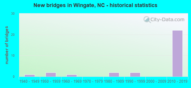
- New bridges - historical statistics
- 11940-1949
- 21950-1959
- 11960-1969
- 21980-1989
- 21990-1999
- 222010-2019
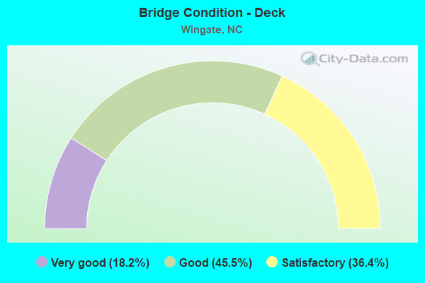
- Bridge Condition - Deck
- 18.2%Very good
- 45.5%Good
- 36.4%Satisfactory
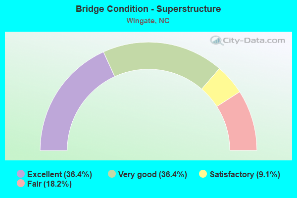
- Bridge Condition - Superstructure
- 36.4%Excellent
- 36.4%Very good
- 9.1%Satisfactory
- 18.2%Fair
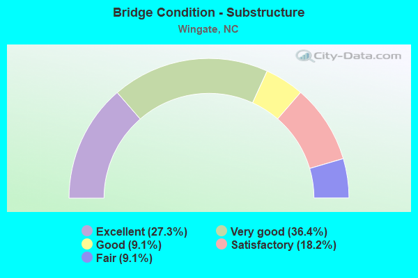
- Bridge Condition - Substructure
- 27.3%Excellent
- 36.4%Very good
- 9.1%Good
- 18.2%Satisfactory
- 9.1%Fair
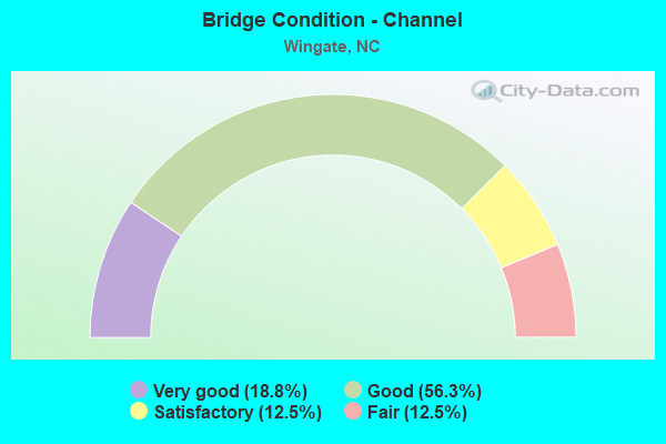
- Bridge Condition - Channel
- 18.8%Very good
- 56.3%Good
- 12.5%Satisfactory
- 12.5%Fair
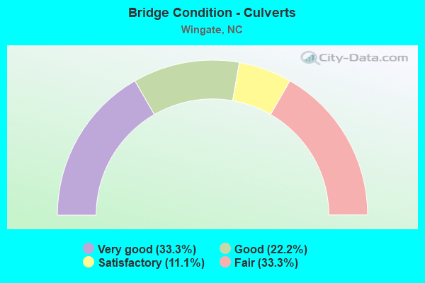
- Bridge Condition - Culverts
- 33.3%Very good
- 22.2%Good
- 11.1%Satisfactory
- 33.3%Fair
Find on map >> Show street view
Structure Number: 1790066, Location: 0.3 MI. W. JCT. SR1755 (Lat: 34.988875, Lng: -80.437033), Route carried "on" structure: State highway 1002, Year Built: 1958, Year Reconstructed: 1975, Status: Posted for load, Structure Length: 0.94m (3.08ft), Average Daily Traffic: 3,900 (year 2012), Truck Traffic: 7%, Average Future Daily Traffic: 7,800 (year 2040), Features Intersected: BRANCH OF MEADOW CREEK
Minimum Vertical Clearance: 30+ m (98+ ft), Kilometerpoint: 0.000, Lanes on structure: 2, Owner: State Highway Agency, Approaching Roadway Width: 7.0m (23.0ft), Material/Design: Steel, Design/Construction: Stringer/Multi-beam, Number Of Spans In Main Unit: 1, Length of Maximum Span: 8.8m (28.9ft), Curb or Sidewalk Widths: Left: 0.1m (0.3ft), Right: 0.1m (0.3ft), Curb-To-Curb Width: 7.2m (23.6ft), Out-to-Out Width: 7.2m (23.6ft)
Condition: Deck: Satisfactory, Superstructure: Fair, Substructure: Satisfactory, Channel: Satisfactory, Operating Rating: 33.5 metric tons, Method Used To Determine Operating Rating: Load Factor (LF), Inventory Rating: 19.9 metric tons, Method Used To Determine Inventory Rating: Load Factor (LF), Structural Evaluation: Somewhat better than minimum adequacy, Deck Geometry: High priority of replacement, Waterway Adequacy: Better than present minimum criteria, Approach Roadway Alignment: Equal to present desirable criteria, Bridge Posting: Required (Relationship of Operating Rating to Maximum Legal Load: 10.0 - 19.9% below), Designated Inspection Frequency: Every 24 months, Inspection Date: November 2020, Deck Structure Type: Corrugated Steel, Wearing Surface/Protective System: Wearing Surface: Bituminous
Find on map >> Show street view
Structure Number: 1790069, Location: 0.4 MI. W. JCT. SR1747 (Lat: 35.036386, Lng: -80.399339), Route carried "on" structure: State highway 1632, Year Built: 2014, Status: Open, Structure Length: 0.88m (2.89ft), Average Daily Traffic: 900 (year 2012), Truck Traffic: 6%, Average Future Daily Traffic: 1,800 (year 2040), Design Load: HL 93, Features Intersected: JACK'S BRANCH
Minimum Vertical Clearance: 30+ m (98+ ft), Kilometerpoint: 0.000, Lanes on structure: 2, Owner: State Highway Agency, Approaching Roadway Width: 6.0m (19.7ft), Skew: 1 degrees, Material/Design: Concrete, Design/Construction: Culvert, Number Of Spans In Main Unit: 1, Length of Maximum Span: 8.5m (27.9ft)
Condition: Channel: Good, Culverts: Good, Operating Rating: 89.8 metric tons, Method Used To Determine Operating Rating: Load and Resistance Factor (LRFR), Inventory Rating: 70.7 metric tons, Method Used To Determine Inventory Rating: Load and Resistance Factor (LRFR), Structural Evaluation: Better than present minimum criteria, Waterway Adequacy: Better than present minimum criteria, Approach Roadway Alignment: Equal to present desirable criteria, Designated Inspection Frequency: Every 24 months, Inspection Date: November 2020
Find on map >> Show street view
Structure Number: 1790074, Location: 0.3 MI. W. JCT. SR1631 (Lat: 35.005581, Lng: -80.446911), Route carried "on" structure: State highway 1751, Year Built: 1963, Year Reconstructed: 1977, Status: Posted for load, Structure Length: 0.70m (2.30ft), Average Daily Traffic: 3,500 (year 2018), Truck Traffic: 7%, Average Future Daily Traffic: 7,000 (year 2040), Features Intersected: MEADOW BRANCH
Minimum Vertical Clearance: 30+ m (98+ ft), Kilometerpoint: 0.000, Lanes on structure: 2, Owner: State Highway Agency, Maintenance Responsibility: State Toll Authority, Approaching Roadway Width: 7.6m (24.9ft), Material/Design: Steel, Design/Construction: Stringer/Multi-beam, Number Of Spans In Main Unit: 1, Length of Maximum Span: 6.7m (22.0ft), Curb-To-Curb Width: 8.3m (27.2ft), Out-to-Out Width: 8.5m (27.9ft)
Condition: Deck: Good, Superstructure: Fair, Substructure: Fair, Channel: Fair, Operating Rating: 33.5 metric tons, Method Used To Determine Operating Rating: Load Factor (LF), Inventory Rating: 19.9 metric tons, Method Used To Determine Inventory Rating: Load Factor (LF), Structural Evaluation: Somewhat better than minimum adequacy, Deck Geometry: High priority of corrective action, Waterway Adequacy: Equal to present minimum criteria, Approach Roadway Alignment: Equal to present desirable criteria, Bridge Posting: Required (Relationship of Operating Rating to Maximum Legal Load: 20.0 - 29.9% below), Designated Inspection Frequency: Every 24 months, Inspection Date: January 2021, Deck Structure Type: Corrugated Steel, Wearing Surface/Protective System: Wearing Surface: Bituminous
Find on map >> Show street view
Structure Number: 1790082, Location: 0.1 MI. N. JCT. SR1962 (Lat: 34.972178, Lng: -80.450153), Route carried "on" structure: State highway 1758, Year Built: 1959, Year Reconstructed: 1981, Status: Open, Structure Length: 1.34m (4.40ft), Average Daily Traffic: 3,100 (year 2019), Truck Traffic: 6%, Average Future Daily Traffic: 6,200 (year 2040), Features Intersected: RAYS FORK
Minimum Vertical Clearance: 30+ m (98+ ft), Kilometerpoint: 0.000, Lanes on structure: 2, Owner: State Highway Agency, Approaching Roadway Width: 7.0m (23.0ft), Material/Design: Steel, Design/Construction: Stringer/Multi-beam, Number Of Spans In Main Unit: 1, Length of Maximum Span: 12.4m (40.7ft), Curb-To-Curb Width: 7.3m (24.0ft), Out-to-Out Width: 7.6m (24.9ft)
Condition: Deck: Satisfactory, Superstructure: Satisfactory, Substructure: Satisfactory, Channel: Good, Operating Rating: 63.5 metric tons, Method Used To Determine Operating Rating: Load Factor (LF), Inventory Rating: 38.1 metric tons, Method Used To Determine Inventory Rating: Load Factor (LF), Structural Evaluation: Equal to present minimum criteria, Deck Geometry: High priority of replacement, Waterway Adequacy: Somewhat better than minimum adequacy, Approach Roadway Alignment: Equal to present desirable criteria, Designated Inspection Frequency: Every 24 months, Inspection Date: June 2021, Deck Structure Type: Corrugated Steel, Wearing Surface/Protective System: Wearing Surface: Bituminous
Find on map >> Show street view
Structure Number: 1790083, Location: 0.4 MI. W. JCT. SR1969 (Lat: 34.965050, Lng: -80.470558), Route carried "on" structure: State highway 1962, Year Built: 1983, Status: Open, Structure Length: 0.76m (2.49ft), Average Daily Traffic: 780 (year 2015), Truck Traffic: 6%, Average Future Daily Traffic: 1,560 (year 2040), Design Load: HS 20+Mod, Features Intersected: MIDDLE FORK RAYS FORK
Minimum Vertical Clearance: 30+ m (98+ ft), Kilometerpoint: 0.000, Lanes on structure: 2, Owner: State Highway Agency, Approaching Roadway Width: 5.1m (16.7ft), Material/Design: Steel, Design/Construction: Culvert, Number Of Spans In Main Unit: 2, Length of Maximum Span: 3.3m (10.8ft)
Condition: Channel: Good, Culverts: Fair, Operating Rating: 89.8 metric tons, Method Used To Determine Operating Rating: Load and Resistance Factor (LRFR), Inventory Rating: 89.8 metric tons, Method Used To Determine Inventory Rating: Load and Resistance Factor (LRFR), Structural Evaluation: Somewhat better than minimum adequacy, Waterway Adequacy: Better than present minimum criteria, Approach Roadway Alignment: Equal to present desirable criteria, Designated Inspection Frequency: Every 24 months, Inspection Date: December 2020
Find on map >> Show street view
Structure Number: 1790087, Location: 0.4 MI. E. JCT. SR1958 (Lat: 34.955028, Lng: -80.440775), Route carried "on" structure: State highway 1957, Year Built: 2013, Status: Open, Structure Length: 1.43m (4.69ft), Average Daily Traffic: 350 (year 2016), Truck Traffic: 6%, Average Future Daily Traffic: 700 (year 2040), Design Load: HL 93, Features Intersected: RAYS FORK CREEK
Minimum Vertical Clearance: 30+ m (98+ ft), Kilometerpoint: 0.000, Lanes on structure: 2, Owner: State Highway Agency, Approaching Roadway Width: 5.4m (17.7ft), Material/Design: Prestressed concrete, Design/Construction: Slab, Number Of Spans In Main Unit: 1, Length of Maximum Span: 13.4m (44.0ft), Curb-To-Curb Width: 8.2m (26.9ft), Out-to-Out Width: 9.1m (29.9ft)
Condition: Deck: Very good, Superstructure: Very good, Substructure: Very good, Channel: Satisfactory, Operating Rating: 75.2 metric tons, Method Used To Determine Operating Rating: Load and Resistance Factor (LRFR), Inventory Rating: 58.0 metric tons, Method Used To Determine Inventory Rating: Load and Resistance Factor (LRFR), Structural Evaluation: Equal to present desirable criteria, Deck Geometry: Somewhat better than minimum adequacy, Waterway Adequacy: Better than present minimum criteria, Approach Roadway Alignment: Equal to present desirable criteria, Designated Inspection Frequency: Every 24 months, Inspection Date: December 2021, Deck Structure Type: Concrete Precast Panels, Wearing Surface/Protective System: Wearing Surface: Bituminous
Find on map >> Show street view
Structure Number: 1790105, Location: 0.25 MI. E. JCT. SR1963 (Lat: 34.981250, Lng: -80.471489), Route carried "on" structure: US 74, Year Built: 1941, Year Reconstructed: 1970, Status: Open, Structure Length: 1.21m (3.97ft), Average Daily Traffic: 28,000 (year 2015), Truck Traffic: 12%, Average Future Daily Traffic: 56,000 (year 2025), Design Load: HS 20+Mod, Features Intersected: RAYS FORK BRANCH
Minimum Vertical Clearance: 30+ m (98+ ft), Kilometerpoint: 0.000, Lanes on structure: 4, Base Highway Network: Yes (Inventory Route: 2, Subroute: 74), Owner: State Highway Agency, Approaching Roadway Width: 18.5m (60.7ft), Skew: 24 degrees, Material/Design: Concrete, Design/Construction: Culvert, Number Of Spans In Main Unit: 1, Length of Maximum Span: 8.5m (27.9ft)
Condition: Channel: Good, Culverts: Fair, Operating Rating: 89.8 metric tons, Method Used To Determine Operating Rating: Load Factor (LF), Inventory Rating: 89.8 metric tons, Method Used To Determine Inventory Rating: Load Factor (LF), Structural Evaluation: Somewhat better than minimum adequacy, Waterway Adequacy: Better than present minimum criteria, Approach Roadway Alignment: Equal to present desirable criteria, Designated Inspection Frequency: Every 24 months, Inspection Date: January 2022
Find on map >> Show street view
Structure Number: 1790361, Location: 0.4 MI. E. JCT. US74 (Lat: 34.979342, Lng: -80.470661), Route carried "on" structure: State highway 1963, Year Built: 1998, Status: Open, Structure Length: 1.03m (3.38ft), Average Daily Traffic: 1,900 (year 2017), Truck Traffic: 7%, Average Future Daily Traffic: 3,800 (year 2040), Design Load: HS 20+Mod, Features Intersected: RAY'S FORK CREEK
Minimum Vertical Clearance: 30+ m (98+ ft), Kilometerpoint: 0.000, Lanes on structure: 2, Owner: State Highway Agency, Approaching Roadway Width: 7.0m (23.0ft), Material/Design: Concrete continuous, Design/Construction: Culvert, Number Of Spans In Main Unit: 3, Length of Maximum Span: 3.3m (10.8ft)
Condition: Channel: Good, Culverts: Satisfactory, Operating Rating: 68.9 metric tons, Method Used To Determine Operating Rating: Load and Resistance Factor (LRFR), Inventory Rating: 53.5 metric tons, Method Used To Determine Inventory Rating: Load and Resistance Factor (LRFR), Structural Evaluation: Equal to present minimum criteria, Waterway Adequacy: Better than present minimum criteria, Approach Roadway Alignment: Equal to present desirable criteria, Designated Inspection Frequency: Every 24 months, Inspection Date: June 2021
Find on map >> Show street view
Structure Number: 179042, Location: 0.8 MI. W. JCT. SR1937 (Lat: 34.932219, Lng: -80.411286), Route carried "on" structure: State highway 1934, Year Built: 1982, Status: Open, Structure Length: 0.88m (2.89ft), Average Daily Traffic: 360 (year 2015), Truck Traffic: 6%, Average Future Daily Traffic: 720 (year 2040), Design Load: HS 20+Mod, Features Intersected: UT TO BEAVERDAM CK
Minimum Vertical Clearance: 30+ m (98+ ft), Kilometerpoint: 0.000, Lanes on structure: 2, Owner: State Highway Agency, Approaching Roadway Width: 5.7m (18.7ft), Skew: 1 degrees, Material/Design: Steel, Design/Construction: Culvert, Number Of Spans In Main Unit: 3, Length of Maximum Span: 2.4m (7.9ft)
Condition: Channel: Fair, Culverts: Fair, Operating Rating: 89.8 metric tons, Method Used To Determine Operating Rating: Load and Resistance Factor (LRFR), Inventory Rating: 87.9 metric tons, Method Used To Determine Inventory Rating: Load and Resistance Factor (LRFR), Structural Evaluation: Somewhat better than minimum adequacy, Waterway Adequacy: Better than present minimum criteria, Approach Roadway Alignment: Equal to present desirable criteria, Designated Inspection Frequency: Every 24 months, Inspection Date: October 2020
Find on map >> Show street view
Structure Number: 1790429, Location: 0.5 MI. S. JCT. SR1751 (Lat: 34.999189, Lng: -80.444000), Route carried "on" structure: State highway 1631, Year Built: 1997, Status: Open, Structure Length: 1.06m (3.48ft), Average Daily Traffic: 1,700 (year 2017), Truck Traffic: 7%, Average Future Daily Traffic: 3,400 (year 2040), Design Load: HS 20+Mod, Features Intersected: MEADOW BRANCH
Minimum Vertical Clearance: 30+ m (98+ ft), Kilometerpoint: 0.000, Lanes on structure: 2, Owner: State Highway Agency, Approaching Roadway Width: 5.4m (17.7ft), Skew: 4 degrees, Material/Design: Concrete continuous, Design/Construction: Culvert, Number Of Spans In Main Unit: 2, Length of Maximum Span: 3.6m (11.8ft)
Condition: Channel: Good, Culverts: Good, Operating Rating: 39.9 metric tons, Method Used To Determine Operating Rating: Load and Resistance Factor (LRFR), Inventory Rating: 30.8 metric tons, Method Used To Determine Inventory Rating: Load and Resistance Factor (LRFR), Structural Evaluation: Better than present minimum criteria, Waterway Adequacy: Better than present minimum criteria, Approach Roadway Alignment: Equal to present desirable criteria, Designated Inspection Frequency: Every 24 months, Inspection Date: December 2020
Find on map >> Show street view
Structure Number: 1790501, Location: 0.1 MI. W. JCT. SR1751 (Lat: 35.000128, Lng: -80.476017), Route carried "on" structure: Bypass US 74, Year Built: 2018, Status: Open, Structure Length: 10.08m (33.07ft), Average Daily Traffic: 20,000 (year 2017), Truck Traffic: 14%, Average Future Daily Traffic: 40,000 (year 2040), Design Load: HL 93, Features Intersected: E. FORK STEWARTS CRK
Minimum Vertical Clearance: 30+ m (98+ ft), Kilometerpoint: 0.000, Lanes on structure: 2, Toll: On toll road, Owner: State Highway Agency, Approaching Roadway Width: 13.4m (44.0ft), Skew: 11 degrees, Material/Design: Prestressed concrete, Design/Construction: Stringer/Multi-beam, Number Of Spans In Main Unit: 3, Length of Maximum Span: 34.4m (112.9ft), Curb-To-Curb Width: 11.9m (39.0ft), Out-to-Out Width: 13.1m (43.0ft)
Condition: Deck: Good, Superstructure: Excellent, Substructure: Excellent, Channel: Very good, Operating Rating: 71.6 metric tons, Method Used To Determine Operating Rating: Load and Resistance Factor (LRFR), Inventory Rating: 48.0 metric tons, Method Used To Determine Inventory Rating: Load and Resistance Factor (LRFR), Structural Evaluation: Superior to present desirable criteria, Deck Geometry: Better than present minimum criteria, Waterway Adequacy: Equal to present desirable criteria, Approach Roadway Alignment: Equal to present desirable criteria, Designated Inspection Frequency: Every 24 months, Inspection Date: June 2020, Deck Structure Type: Concrete Cast-file-Place, Wearing Surface/Protective System: Wearing Surface: Monolithic Concrete
Find on map >> Show street view
Structure Number: 1790503, Location: 1.5 MI W JCT AUSTINCHANEY (Lat: 34.999531, Lng: -80.474006), Route carried "on" structure: Bypass US 74, Year Built: 2018, Status: Open, Structure Length: 2.28m (7.48ft), Average Daily Traffic: 10,000 (year 2017), Truck Traffic: 12%, Average Future Daily Traffic: 20,000 (year 2040), Design Load: HL 93, Features Intersected: MONROE ANSONVILLE(SR1751
Minimum Vertical Clearance: 30+ m (98+ ft), Kilometerpoint: 0.000, Lanes on structure: 2, Lanes under structure: 2, Owner: State Highway Agency, Approaching Roadway Width: 13.1m (43.0ft), Skew: 3 degrees, Material/Design: Prestressed concrete, Design/Construction: Stringer/Multi-beam, Number Of Spans In Main Unit: 1, Length of Maximum Span: 21.3m (69.9ft), Curb-To-Curb Width: 11.9m (39.0ft), Out-to-Out Width: 13.2m (43.3ft)
Condition: Deck: Good, Superstructure: Excellent, Substructure: Very good, Operating Rating: 54.4 metric tons, Method Used To Determine Operating Rating: Load and Resistance Factor (LRFR), Inventory Rating: 42.6 metric tons, Method Used To Determine Inventory Rating: Load and Resistance Factor (LRFR), Structural Evaluation: Equal to present desirable criteria, Deck Geometry: Somewhat better than minimum adequacy, Underclear: Somewhat better than minimum adequacy, Approach Roadway Alignment: Equal to present desirable criteria, Designated Inspection Frequency: Every 24 months, Inspection Date: June 2020, Deck Structure Type: Concrete Cast-file-Place
Find on map >> Show street view
Structure Number: 1790504, Location: 1.5MI W JCT.AUSTIN CHANEY (Lat: 34.999361, Lng: -80.474261), Route carried "on" structure: Bypass US 74, Year Built: 2018, Status: Open, Structure Length: 2.28m (7.48ft), Average Daily Traffic: 10,000 (year 2017), Truck Traffic: 12%, Average Future Daily Traffic: 20,000 (year 2040), Design Load: HL 93, Features Intersected: MONROE ANSONVILLE (SR175
Minimum Vertical Clearance: 30+ m (98+ ft), Kilometerpoint: 0.000, Lanes on structure: 2, Lanes under structure: 2, Owner: State Highway Agency, Approaching Roadway Width: 13.1m (43.0ft), Skew: 3 degrees, Material/Design: Prestressed concrete, Design/Construction: Stringer/Multi-beam, Number Of Spans In Main Unit: 1, Length of Maximum Span: 21.3m (69.9ft), Curb-To-Curb Width: 11.9m (39.0ft), Out-to-Out Width: 13.2m (43.3ft)
Condition: Deck: Good, Superstructure: Very good, Substructure: Very good, Operating Rating: 71.6 metric tons, Method Used To Determine Operating Rating: Load and Resistance Factor (LRFR), Inventory Rating: 42.6 metric tons, Method Used To Determine Inventory Rating: Load and Resistance Factor (LRFR), Structural Evaluation: Equal to present desirable criteria, Deck Geometry: Better than present minimum criteria, Underclear: Somewhat better than minimum adequacy, Approach Roadway Alignment: Equal to present desirable criteria, Designated Inspection Frequency: Every 24 months, Inspection Date: June 2020, Deck Structure Type: Concrete Cast-file-Place
Find on map >> Show street view
Structure Number: 1790506, Location: .2 MI N. SR 1631 (Lat: 34.997686, Lng: -80.448817), Route carried "on" structure: State highway 1758, Year Built: 2016, Status: Open, Structure Length: 5.18m (16.99ft), Average Daily Traffic: 3,500 (year 2018), Truck Traffic: 6%, Average Future Daily Traffic: 7,000 (year 2040), Design Load: HL 93, Features Intersected: US74 BYP
Minimum Vertical Clearance: 30+ m (98+ ft), Kilometerpoint: 0.000, Lanes on structure: 2, Lanes under structure: 6, Owner: State Highway Agency, Approaching Roadway Width: 11.2m (36.7ft), Skew: 3 degrees, Material/Design: Prestressed concrete continuous, Design/Construction: Stringer/Multi-beam, Length of Maximum Span: 24.9m (81.7ft), Curb-To-Curb Width: 11.3m (37.1ft), Out-to-Out Width: 12.8m (42.0ft)
Condition: Deck: Good, Superstructure: Excellent, Substructure: Excellent, Operating Rating: 81.6 metric tons, Method Used To Determine Operating Rating: Load and Resistance Factor (LRFR), Inventory Rating: 55.3 metric tons, Method Used To Determine Inventory Rating: Load and Resistance Factor (LRFR), Structural Evaluation: Superior to present desirable criteria, Deck Geometry: Somewhat better than minimum adequacy, Underclear: Meets minimum limits, Approach Roadway Alignment: Equal to present desirable criteria, Designated Inspection Frequency: Every 24 months, Inspection Date: June 2021, Deck Structure Type: Concrete Cast-file-Place, Wearing Surface/Protective System: Wearing Surface: Monolithic Concrete
Find on map >> Show street view
Structure Number: 1790507, Location: 1.3 MI E JCT AUSTINCHANEY (Lat: 34.997692, Lng: -80.443281), Route carried "on" structure: US 74, Year Built: 2018, Status: Open, Structure Length: 21.45m (70.37ft), Average Daily Traffic: 10,000 (year 2017), Truck Traffic: 14%, Average Future Daily Traffic: 20,000 (year 2040), Design Load: HL 93, Features Intersected: MCINTYRE & MEADOW BRANCH
Minimum Vertical Clearance: 30+ m (98+ ft), Kilometerpoint: 82.540, Lanes on structure: 2, Lanes under structure: 2, Owner: State Highway Agency, Approaching Roadway Width: 17.3m (56.8ft), Skew: 1 degrees, Material/Design: Prestressed concrete, Design/Construction: Stringer/Multi-beam, Number Of Spans In Main Unit: 6, Length of Maximum Span: 36.8m (120.7ft), Curb-To-Curb Width: 11.9m (39.0ft), Out-to-Out Width: 13.1m (43.0ft)
Condition: Deck: Satisfactory, Superstructure: Very good, Substructure: Good, Channel: Very good, Operating Rating: 54.4 metric tons, Method Used To Determine Operating Rating: Load and Resistance Factor (LRFR), Inventory Rating: 42.6 metric tons, Method Used To Determine Inventory Rating: Load and Resistance Factor (LRFR), Structural Evaluation: Better than present minimum criteria, Deck Geometry: Better than present minimum criteria, Underclear: Superior to present desirable criteria, Waterway Adequacy: Equal to present desirable criteria, Approach Roadway Alignment: Equal to present desirable criteria, Designated Inspection Frequency: Every 24 months, Inspection Date: June 2020, Deck Structure Type: Concrete Cast-file-Place, Wearing Surface/Protective System: Wearing Surface: Monolithic Concrete
Find on map >> Show street view
Structure Number: 1790508, Location: 1.3MI E JCT AUSTIN CHANEY (Lat: 34.997433, Lng: -80.443469), Route carried "on" structure: US 74, Year Built: 2018, Status: Open, Structure Length: 21.88m (71.78ft), Average Daily Traffic: 10,000 (year 2017), Truck Traffic: 14%, Average Future Daily Traffic: 20,000 (year 2040), Design Load: HL 93, Features Intersected: MCINTYRE & MEADOW BRANCH
Minimum Vertical Clearance: 30+ m (98+ ft), Kilometerpoint: 0.000, Lanes on structure: 2, Lanes under structure: 2, Owner: State Highway Agency, Approaching Roadway Width: 14.6m (47.9ft), Skew: 1 degrees, Material/Design: Prestressed concrete, Design/Construction: Stringer/Multi-beam, Number Of Spans In Main Unit: 6, Length of Maximum Span: 36.8m (120.7ft), Curb-To-Curb Width: 11.9m (39.0ft), Out-to-Out Width: 13.1m (43.0ft)
Condition: Deck: Satisfactory, Superstructure: Very good, Substructure: Very good, Channel: Very good, Operating Rating: 54.4 metric tons, Method Used To Determine Operating Rating: Load and Resistance Factor (LRFR), Inventory Rating: 42.6 metric tons, Method Used To Determine Inventory Rating: Load and Resistance Factor (LRFR), Structural Evaluation: Equal to present desirable criteria, Deck Geometry: Better than present minimum criteria, Underclear: Better than present minimum criteria, Waterway Adequacy: Equal to present desirable criteria, Approach Roadway Alignment: Equal to present desirable criteria, Designated Inspection Frequency: Every 24 months, Inspection Date: June 2020, Deck Structure Type: Concrete Cast-file-Place, Wearing Surface/Protective System: Wearing Surface: Monolithic Concrete
Find on map >> Show street view
Structure Number: 1790509, Location: .36 MI N. SR 1753 (Lat: 34.997342, Lng: -80.431739), Route carried "on" structure: State highway 1002, Year Built: 2016, Status: Open, Structure Length: 4.08m (13.39ft), Average Daily Traffic: 1,400 (year 2018), Truck Traffic: 7%, Average Future Daily Traffic: 2,800 (year 2040), Design Load: HL 93, Features Intersected: US 74 BYPASS
Minimum Vertical Clearance: 30+ m (98+ ft), Kilometerpoint: 0.000, Lanes on structure: 2, Lanes under structure: 4, Owner: State Highway Agency, Approaching Roadway Width: 9.1m (29.9ft), Material/Design: Prestressed concrete continuous, Design/Construction: Stringer/Multi-beam, Length of Maximum Span: 19.5m (64.0ft), Curb-To-Curb Width: 8.5m (27.9ft), Out-to-Out Width: 10.1m (33.1ft)
Condition: Deck: Very good, Superstructure: Excellent, Substructure: Excellent, Operating Rating: 89.8 metric tons, Method Used To Determine Operating Rating: Load and Resistance Factor (LRFR), Inventory Rating: 61.6 metric tons, Method Used To Determine Inventory Rating: Load and Resistance Factor (LRFR), Structural Evaluation: Superior to present desirable criteria, Deck Geometry: Somewhat better than minimum adequacy, Underclear: Somewhat better than minimum adequacy, Approach Roadway Alignment: Equal to present desirable criteria, Designated Inspection Frequency: Every 24 months, Inspection Date: June 2021, Deck Structure Type: Concrete Cast-file-Place, Wearing Surface/Protective System: Wearing Surface: Monolithic Concrete
Find on map >> Show street view
Structure Number: 1790571, Location: 1.18 MI.W.JCT.SR1758 (Lat: 34.998333, Lng: -80.470000), Route carried "on" structure: Bypass US 74, Year Built: 2018, Status: Open, Structure Length: 0.73m (2.40ft), Average Daily Traffic: 24,650 (year 2013), Truck Traffic: 14%, Average Future Daily Traffic: 493,000 (year 2040), Design Load: HL 93, Features Intersected: UT TO RAYS FORK CREEK
Minimum Vertical Clearance: 30+ m (98+ ft), Kilometerpoint: 81.687, Lanes on structure: 4, Base Highway Network: Yes (Inventory Route: 2, Subroute: 74), Owner: State Highway Agency, Approaching Roadway Width: 25.2m (82.7ft), Skew: 6 degrees, Material/Design: Concrete continuous, Design/Construction: Culvert, Number Of Spans In Main Unit: 2, Length of Maximum Span: 2.7m (8.9ft)
Condition: Channel: Good, Culverts: Very good, Operating Rating: 72.5 metric tons, Method Used To Determine Operating Rating: Load and Resistance Factor (LRFR), Inventory Rating: 55.3 metric tons, Method Used To Determine Inventory Rating: Load and Resistance Factor (LRFR), Structural Evaluation: Equal to present desirable criteria, Waterway Adequacy: Better than present minimum criteria, Approach Roadway Alignment: Equal to present desirable criteria, Designated Inspection Frequency: Every 24 months, Inspection Date: October 2020
Find on map >> Show street view
Structure Number: 1790572, Location: 150 FT.E.JCT. SR1758 (Lat: 34.997500, Lng: -80.448056), Route carried "on" structure: Bypass State lands road 74, Year Built: 2018, Status: Open, Structure Length: 0.73m (2.40ft), Average Daily Traffic: 24,650 (year 2013), Truck Traffic: 14%, Average Future Daily Traffic: 49,300 (year 2040), Design Load: HL 93, Features Intersected: SPRING BRANCH
Minimum Vertical Clearance: 30+ m (98+ ft), Kilometerpoint: 82.388, Lanes on structure: 4, Base Highway Network: Yes (Inventory Route: 2, Subroute: 74), Toll: On toll road, Owner: State Highway Agency, Approaching Roadway Width: 35.3m (115.8ft), Skew: 13 degrees, Material/Design: Concrete continuous, Design/Construction: Culvert, Number Of Spans In Main Unit: 2, Length of Maximum Span: 3.0m (9.8ft)
Condition: Channel: Good, Culverts: Very good, Operating Rating: 55.3 metric tons, Method Used To Determine Operating Rating: Load and Resistance Factor (LRFR), Inventory Rating: 42.6 metric tons, Method Used To Determine Inventory Rating: Load and Resistance Factor (LRFR), Structural Evaluation: Equal to present desirable criteria, Waterway Adequacy: Better than present minimum criteria, Approach Roadway Alignment: Equal to present desirable criteria, Designated Inspection Frequency: Every 24 months, Inspection Date: October 2020
Find on map >> Show street view
Structure Number: 1790573, Location: 150 FT.W. SR1758 (Lat: 34.995833, Lng: -80.449167), Route carried "on" structure: Ramp US 74, Year Built: 2018, Status: Open, Structure Length: 0.70m (2.30ft), Average Daily Traffic: 4,590 (year 2013), Truck Traffic: 14%, Average Future Daily Traffic: 9,180 (year 2040), Design Load: HL 93, Features Intersected: SPRING BRANCH
Minimum Vertical Clearance: 30+ m (98+ ft), Kilometerpoint: 0.000, Lanes on structure: 2, Base Highway Network: Yes (Inventory Route: 2, Subroute: 74), Toll: On toll road, Owner: State Highway Agency, Approaching Roadway Width: 18.5m (60.7ft), Skew: 12 degrees, Material/Design: Concrete continuous, Design/Construction: Culvert, Number Of Spans In Main Unit: 2, Length of Maximum Span: 3.0m (9.8ft)
Condition: Channel: Good, Culverts: Very good, Operating Rating: 89.8 metric tons, Method Used To Determine Operating Rating: Load and Resistance Factor (LRFR), Inventory Rating: 61.6 metric tons, Method Used To Determine Inventory Rating: Load and Resistance Factor (LRFR), Structural Evaluation: Equal to present desirable criteria, Waterway Adequacy: Better than present minimum criteria, Approach Roadway Alignment: Equal to present desirable criteria, Designated Inspection Frequency: Every 24 months, Inspection Date: October 2020
Find on map >> Show street view
Structure Number: 1790503, Location: 1.5 MI W JCT AUSTINCHANEY (Lat: 34.999531, Lng: -80.474006), Route carried "under" structure: State highway 1751, Year Built: 2018, Structure Length: 0. m, Average Daily Traffic: 4,500 (year 2016), Truck Traffic: 7%, Features Intersected: US74 BYP. WBL
Minimum Vertical Clearance: 5.46m (17.91ft), Kilometerpoint: 0.000, Lanes on structure: 2, Lanes under structure: 2, Material/Design: Prestressed concrete, Design/Construction: Stringer/Multi-beam, Length of Maximum Span: 21.3m (69.9ft)
Find on map >> Show street view
Structure Number: 1790504, Location: 1.5MI W JCT.AUSTIN CHANEY (Lat: 34.999361, Lng: -80.474261), Route carried "under" structure: State highway 1751, Year Built: 2018, Structure Length: 0. m, Average Daily Traffic: 4,800 (year 2018), Truck Traffic: 7%, Features Intersected: US74 BYP EBL
Minimum Vertical Clearance: 6.80m (22.31ft), Kilometerpoint: 0.000, Lanes on structure: 2, Lanes under structure: 2, Material/Design: Prestressed concrete, Design/Construction: Stringer/Multi-beam, Length of Maximum Span: 21.3m (69.9ft)
Find on map >> Show street view
Structure Number: 1790506, Location: .2 MI N. SR 1631 (Lat: 34.997686, Lng: -80.448817), Route carried "under" structure: Bypass US 74, Year Built: 2016, Structure Length: 0. m, Average Daily Traffic: 15,000 (year 2019), Truck Traffic: 14%, Features Intersected: SR 1758
Minimum Vertical Clearance: 5.48m (17.98ft), Kilometerpoint: 82.449, Lanes on structure: 2, Lanes under structure: 3, Material/Design: Prestressed concrete continuous, Design/Construction: Stringer/Multi-beam, Length of Maximum Span: 24.9m (81.7ft)
Find on map >> Show street view
Structure Number: 1790506, Location: .2 MI N. SR 1631 (Lat: 34.997686, Lng: -80.448817), Route carried "under" structure: Bypass US 74, Year Built: 2016, Structure Length: 0. m, Average Daily Traffic: 15,000 (year 2019), Truck Traffic: 14%, Features Intersected: SR 1758
Minimum Vertical Clearance: 5.81m (19.06ft), Kilometerpoint: 82.449, Lanes on structure: 2, Lanes under structure: 3, Material/Design: Prestressed concrete continuous, Design/Construction: Stringer/Multi-beam, Length of Maximum Span: 24.9m (81.7ft)
Find on map >> Show street view
Structure Number: 1790507, Location: 1.3 MI E JCT AUSTINCHANEY (Lat: 34.997692, Lng: -80.443281), Route carried "under" structure: State highway 1631, Year Built: 2018, Structure Length: 0. m, Average Daily Traffic: 1,700 (year 2017), Truck Traffic: 6%, Features Intersected: US74 BYP WBL
Minimum Vertical Clearance: 6.03m (19.78ft), Kilometerpoint: 0.000, Lanes on structure: 2, Lanes under structure: 2, Material/Design: Prestressed concrete, Design/Construction: Stringer/Multi-beam, Length of Maximum Span: 36.8m (120.7ft)
Find on map >> Show street view
Structure Number: 1790508, Location: 1.3MI E JCT AUSTIN CHANEY (Lat: 34.997433, Lng: -80.443469), Route carried "under" structure: State highway 1631, Year Built: 2018, Structure Length: 0. m, Average Daily Traffic: 1,700 (year 2017), Truck Traffic: 6%, Features Intersected: US74 BYP EBL
Minimum Vertical Clearance: 4.80m (15.75ft), Kilometerpoint: 0.000, Lanes on structure: 2, Lanes under structure: 2, Material/Design: Prestressed concrete, Design/Construction: Stringer/Multi-beam, Length of Maximum Span: 36.8m (120.7ft)
Find on map >> Show street view
Structure Number: 1790509, Location: .36 MI N. SR 1753 (Lat: 34.997342, Lng: -80.431739), Route carried "under" structure: Bypass US 74, Year Built: 2016, Structure Length: 0. m, Average Daily Traffic: 15,000 (year 2019), Truck Traffic: 12%, Features Intersected: SR 1002
Minimum Vertical Clearance: 5.48m (17.98ft), Kilometerpoint: 82.754, Lanes on structure: 2, Lanes under structure: 2, Material/Design: Prestressed concrete continuous, Design/Construction: Stringer/Multi-beam, Length of Maximum Span: 19.5m (64.0ft)
Find on map >> Show street view
Structure Number: 1790509, Location: .36 MI N. SR 1753 (Lat: 34.997342, Lng: -80.431739), Route carried "under" structure: Bypass US 74, Year Built: 2016, Structure Length: 0. m, Average Daily Traffic: 15,000 (year 2019), Truck Traffic: 12%, Features Intersected: SR 1002
Minimum Vertical Clearance: 5.58m (18.31ft), Kilometerpoint: 82.754, Lanes on structure: 2, Lanes under structure: 2, Material/Design: Prestressed concrete continuous, Design/Construction: Stringer/Multi-beam, Length of Maximum Span: 19.5m (64.0ft)
Find on map >> Show street view
Structure Number: 179051, Location: 0.1 MI.N.JCT SR1753 (Lat: 34.992733, Lng: -80.416225), Route carried "under" structure: Bypass US 74, Year Built: 2018, Structure Length: 0. m, Average Daily Traffic: 5,000 (year 2015), Truck Traffic: 14%, Features Intersected: SR1754
Minimum Vertical Clearance: 5.51m (18.08ft), Kilometerpoint: 83.028, Lanes on structure: 2, Lanes under structure: 2, Material/Design: Prestressed concrete continuous, Design/Construction: Stringer/Multi-beam, Length of Maximum Span: 19.8m (65.0ft)
Find on map >> Show street view
Structure Number: 179051, Location: 0.1 MI.N.JCT SR1753 (Lat: 34.992733, Lng: -80.416225), Route carried "under" structure: Bypass US 74, Year Built: 2018, Structure Length: 0. m, Average Daily Traffic: 5,000 (year 2015), Truck Traffic: 14%, Features Intersected: SR1754
Minimum Vertical Clearance: 6.09m (19.98ft), Kilometerpoint: 83.028, Lanes on structure: 2, Lanes under structure: 2, Material/Design: Prestressed concrete continuous, Design/Construction: Stringer/Multi-beam, Length of Maximum Span: 19.8m (65.0ft)