Bridge Statistics for Woodbridge, Connecticut (CT)
Condition, Traffic, Stress, Structural Evaluation, Project Costs
- National Bridge Inventory (NBI) Statistics
- 11Number of bridges
- 105ft / 31.7mTotal length
- 224,687Total average daily traffic
- 9,413Total average daily truck traffic
- National Bridge Inventory (NBI) Registered Bridges for Woodbridge
- No street view available for this location
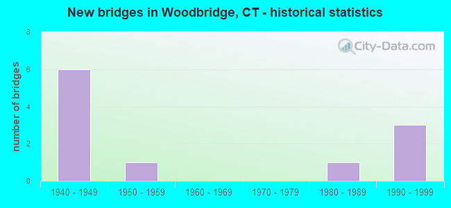
- New bridges - historical statistics
- 61940-1949
- 11950-1959
- 11980-1989
- 31990-1999
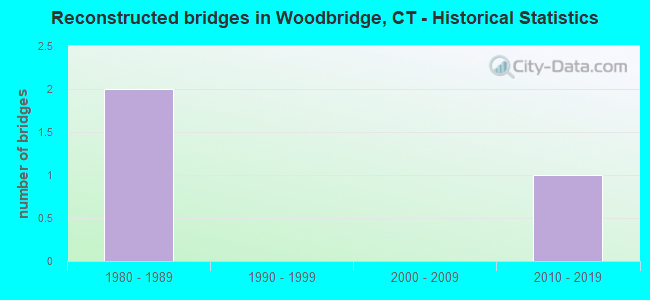
- Reconstructed bridges - Historical Statistics
- 21980-1989
- 01990-1999
- 02000-2009
- 12010-2019
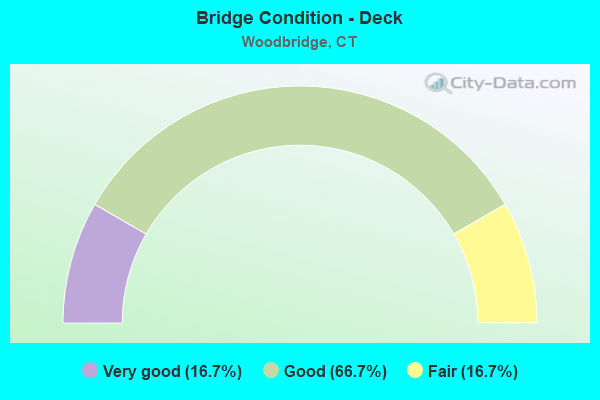
- Bridge Condition - Deck
- 16.7%Very good
- 66.7%Good
- 16.7%Fair
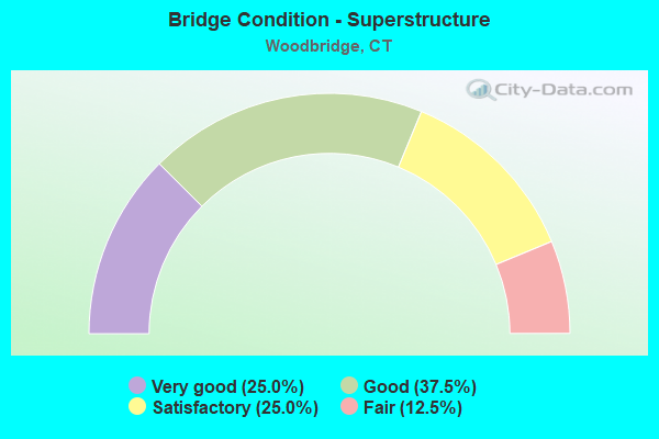
- Bridge Condition - Superstructure
- 25.0%Very good
- 37.5%Good
- 25.0%Satisfactory
- 12.5%Fair
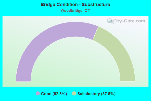
- Bridge Condition - Substructure
- 62.5%Good
- 37.5%Satisfactory
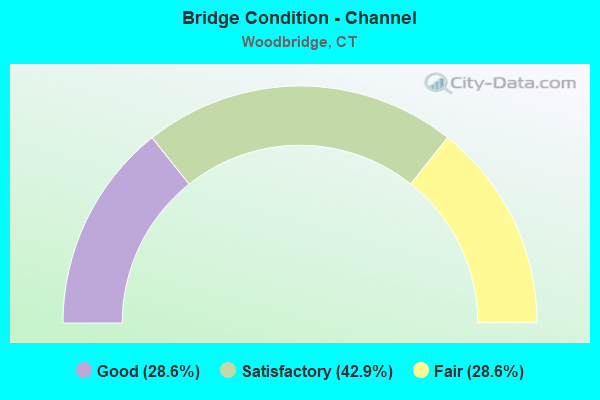
- Bridge Condition - Channel
- 28.6%Good
- 42.9%Satisfactory
- 28.6%Fair
Find on map >> Show street view
Structure Number: 286, Location: 0.2 MILE NORTH OF RTE 12 (Lat: 41.589564, Lng: -71.986689), Route carried "on" structure: Interstate 395, Year Built: 1958, Year Reconstructed: 1986, Status: Open, Structure Length: 18.23m (59.81ft), Average Daily Traffic: 39,800 (year 2017), Truck Traffic: 16%, Average Future Daily Traffic: 59,139 (year 2037), Design Load: H 20, Features Intersected: QUINEBAUG RV & P&W RR
Minimum Vertical Clearance: 30+ m (98+ ft), Kilometerpoint: 34.343, Lanes on structure: 5, Base Highway Network: Yes, Owner: State Highway Agency, Approaching Roadway Width: 24.1m (79.1ft), Skew: 22 degrees, Material/Design: Steel, Design/Construction: Stringer/Multi-beam, Number Of Spans In Main Unit: 8, Length of Maximum Span: 24.2m (79.4ft), Curb-To-Curb Width: 24.1m (79.1ft), Out-to-Out Width: 32.5m (106.6ft)
Condition: Deck: Fair, Superstructure: Fair, Substructure: Satisfactory, Channel: Satisfactory, Operating Rating: 86.7 metric tons, Method Used To Determine Operating Rating: Load Factor (LF), Inventory Rating: 52.0 metric tons, Method Used To Determine Inventory Rating: Load Factor (LF), Structural Evaluation: Somewhat better than minimum adequacy, Deck Geometry: Equal to present minimum criteria, Underclear: Meets minimum limits, Waterway Adequacy: Equal to present desirable criteria, Approach Roadway Alignment: Equal to present desirable criteria, Designated Inspection Frequency: Every 24 months, Underwater Inspection Frequency: Every 24 months, Inspection Date: November 2019, Underwater Inspection Date: July 2021, Deck Structure Type: Concrete Cast-file-Place, Wearing Surface/Protective System: Wearing Surface: Bituminous, Membrane: Preformed Fabric, Deck Protection: Epoxy Coated Reinforcing
Find on map >> Show street view
Structure Number: 492, Location: 0.3 MI EAST CHAPLIN T.L. (Lat: 41.769247, Lng: -72.090444), Route carried "on" structure: US 6, Year Built: 1948, Year Reconstructed: 1991, Status: Open, Structure Length: 1.89m (6.20ft), Average Daily Traffic: 8,900 (year 2019), Truck Traffic: 3%, Average Future Daily Traffic: 13,225 (year 2039), Design Load: HS 20, Features Intersected: MERRICK BROOK AND TRAIL
Minimum Vertical Clearance: 30+ m (98+ ft), Kilometerpoint: 159.776, Lanes on structure: 2, Base Highway Network: Yes, Owner: State Highway Agency, Approaching Roadway Width: 12.2m (40.0ft), Skew: 3 degrees, Material/Design: Steel, Design/Construction: Stringer/Multi-beam, Number Of Spans In Main Unit: 1, Length of Maximum Span: 17.1m (56.1ft), Curb or Sidewalk Widths: Left: 0.8m (2.6ft), Right: 0.8m (2.6ft), Curb-To-Curb Width: 11.8m (38.7ft), Out-to-Out Width: 13.4m (44.0ft)
Condition: Deck: Good, Superstructure: Good, Substructure: Good, Channel: Good, Inventory Rating: 67.7 metric tons, Method Used To Determine Inventory Rating: Load Factor (LF), Structural Evaluation: Better than present minimum criteria, Deck Geometry: Somewhat better than minimum adequacy, Waterway Adequacy: Equal to present minimum criteria, Approach Roadway Alignment: Equal to present desirable criteria, Designated Inspection Frequency: Every 24 months, Inspection Date: December 2021, Deck Structure Type: Concrete Cast-file-Place, Wearing Surface/Protective System: Wearing Surface: Bituminous, Membrane: Preformed Fabric, Deck Protection: Epoxy Coated Reinforcing
Find on map >> Show street view
Structure Number: 768, Location: 0.9 MI N OF ROUTE 34 (Lat: 41.313644, Lng: -73.021492), Route carried "on" structure: State highway 114, Year Built: 1949, Status: Open, Structure Length: 2.65m (8.69ft), Average Daily Traffic: 8,800 (year 2016), Truck Traffic: 5%, Average Future Daily Traffic: 13,076 (year 2036), Features Intersected: ROUTE 15
Minimum Vertical Clearance: 30+ m (98+ ft), Kilometerpoint: 5.407, Lanes on structure: 2, Lanes under structure: 4, Owner: State Highway Agency, Approaching Roadway Width: 14.6m (47.9ft), Material/Design: Concrete, Design/Construction: Frame, Number Of Spans In Main Unit: 2, Length of Maximum Span: 11.3m (37.1ft), Curb or Sidewalk Widths: Left: 0.4m (1.3ft), Right: 0.4m (1.3ft), Curb-To-Curb Width: 12.8m (42.0ft), Out-to-Out Width: 14.4m (47.2ft)
Condition: Superstructure: Satisfactory, Substructure: Satisfactory, Operating Rating: 52.6 metric tons, Method Used To Determine Operating Rating: Field evaluation and documented engineering judgment, Inventory Rating: 30.8 metric tons, Method Used To Determine Inventory Rating: Field evaluation and documented engineering judgment, Structural Evaluation: Equal to present minimum criteria, Deck Geometry: Somewhat better than minimum adequacy, Underclear: High priority of corrective action, Approach Roadway Alignment: Equal to present desirable criteria, Designated Inspection Frequency: Every 24 months, Inspection Date: December 2020
Find on map >> Show street view
Structure Number: 769, Location: 1.1 MI N OF ROUTE 114 (Lat: 41.319342, Lng: -73.001389), Route carried "on" structure: City street , Year Built: 1949, Status: Open, Structure Length: 2.99m (9.81ft), Average Daily Traffic: 1,842 (year 2020), Truck Traffic: 2%, Average Future Daily Traffic: 2,737 (year 2040), Features Intersected: ROUTE 15, Facility Carried by Structure: JOHNSON ROAD
Minimum Vertical Clearance: 30+ m (98+ ft), Kilometerpoint: 0.740, Lanes on structure: 2, Lanes under structure: 4, Owner: State Highway Agency, Approaching Roadway Width: 7.3m (24.0ft), Skew: 2 degrees, Material/Design: Concrete, Design/Construction: Arch - Deck, Number Of Spans In Main Unit: 2, Length of Maximum Span: 13.7m (44.9ft), Curb-To-Curb Width: 11.0m (36.1ft), Out-to-Out Width: 12.9m (42.3ft)
Condition: Superstructure: Satisfactory, Substructure: Satisfactory, Operating Rating: 52.6 metric tons, Method Used To Determine Operating Rating: Field evaluation and documented engineering judgment, Inventory Rating: 30.8 metric tons, Method Used To Determine Inventory Rating: Field evaluation and documented engineering judgment, Structural Evaluation: Equal to present minimum criteria, Deck Geometry: Equal to present minimum criteria, Underclear: High priority of corrective action, Approach Roadway Alignment: Equal to present desirable criteria, Designated Inspection Frequency: Every 24 months, Inspection Date: December 2020
Find on map >> Show street view
Structure Number: 2638, Location: 1.1 MI N OF ROUTE 243 (Lat: 41.344017, Lng: -73.026728), Route carried "on" structure: State highway 114, Year Built: 1996, Status: Open, Structure Length: 0.73m (2.40ft), Average Daily Traffic: 7,200 (year 2015), Truck Traffic: 3%, Average Future Daily Traffic: 10,698 (year 2035), Features Intersected: WEPAWAUG RIVER
Minimum Vertical Clearance: 30+ m (98+ ft), Kilometerpoint: 8.835, Lanes on structure: 2, Owner: State Highway Agency, Approaching Roadway Width: 10.4m (34.1ft), Skew: 4 degrees, Material/Design: Concrete, Design/Construction: Frame, Number Of Spans In Main Unit: 1, Length of Maximum Span: 7.3m (24.0ft), Curb-To-Curb Width: 10.4m (34.1ft), Out-to-Out Width: 11.3m (37.1ft)
Condition: Deck: Good, Superstructure: Good, Substructure: Good, Channel: Satisfactory, Operating Rating: 52.6 metric tons, Method Used To Determine Operating Rating: Field evaluation and documented engineering judgment, Inventory Rating: 30.8 metric tons, Method Used To Determine Inventory Rating: Field evaluation and documented engineering judgment, Structural Evaluation: Better than present minimum criteria, Deck Geometry: Meets minimum limits, Waterway Adequacy: Equal to present minimum criteria, Approach Roadway Alignment: Equal to present desirable criteria, Designated Inspection Frequency: Every 24 months, Inspection Date: May 2021, Deck Structure Type: Other, Wearing Surface/Protective System: Wearing Surface: Bituminous, Membrane: Built-up, Deck Protection: Epoxy Coated Reinforcing
Find on map >> Show street view
Structure Number: 286, Location: 0.6 MILE WEST ROUTE 313 (Lat: 41.331350, Lng: -73.006222), Route carried "on" structure: State highway 243, Year Built: 1996, Status: Open, Structure Length: 0.79m (2.59ft), Average Daily Traffic: 3,700 (year 2015), Truck Traffic: 3%, Average Future Daily Traffic: 5,498 (year 2035), Design Load: HL 93, Features Intersected: RACE BROOK
Minimum Vertical Clearance: 30+ m (98+ ft), Kilometerpoint: 6.743, Lanes on structure: 2, Owner: State Highway Agency, Approaching Roadway Width: 8.5m (27.9ft), Skew: 3 degrees, Material/Design: Concrete, Design/Construction: Culvert, Number Of Spans In Main Unit: 1, Length of Maximum Span: 7.3m (24.0ft), Curb-To-Curb Width: 8.5m (27.9ft), Out-to-Out Width: 9.7m (31.8ft)
Condition: Channel: Fair, Culverts: Satisfactory, Operating Rating: 52.2 metric tons, Method Used To Determine Operating Rating: Load and Resistance Factor Rating (LRFR) rating reported by rating factor(RF) method using HL-93 loadings, Inventory Rating: 40.2 metric tons, Method Used To Determine Inventory Rating: Load and Resistance Factor Rating (LRFR) rating reported by rating factor(RF) method using HL-93 loadings, Structural Evaluation: Equal to present minimum criteria, Deck Geometry: Meets minimum limits, Waterway Adequacy: Equal to present desirable criteria, Approach Roadway Alignment: Equal to present desirable criteria, Designated Inspection Frequency: Every 24 months, Inspection Date: August 2021, Deck Structure Type: Other, Wearing Surface/Protective System: Wearing Surface: Bituminous, Membrane: Preformed Fabric, Deck Protection: Epoxy Coated Reinforcing
Find on map >> Show street view
Structure Number: 492, Location: 100 FT E OF ROUTE 69 (Lat: 41.341103, Lng: -72.977214), Route carried "on" structure: City street , Year Built: 1940, Year Reconstructed: 2015, Status: Open, Structure Length: 1.71m (5.61ft), Average Daily Traffic: 1,208 (year 2010), Truck Traffic: 2%, Average Future Daily Traffic: 1,795 (year 2030), Design Load: HL 93, Features Intersected: WEST RIVER, Facility Carried by Structure: MERRITT AVENUE
Minimum Vertical Clearance: 30+ m (98+ ft), Kilometerpoint: 0.048, Lanes on structure: 2, Owner: Town or Township Highway Agency, Approaching Roadway Width: 7.3m (24.0ft), Skew: 2 degrees, Material/Design: Prestressed concrete, Design/Construction: Box Beam or Girders - Multiple, Number Of Spans In Main Unit: 1, Length of Maximum Span: 15.9m (52.2ft), Curb or Sidewalk Widths: Left: 0.0m, Right: 1.5m (4.9ft), Curb-To-Curb Width: 7.3m (24.0ft), Out-to-Out Width: 11.3m (37.1ft)
Condition: Deck: Very good, Superstructure: Very good, Substructure: Good, Channel: Good, Operating Rating: 53.8 metric tons, Method Used To Determine Operating Rating: Load and Resistance Factor Rating (LRFR) rating reported by rating factor(RF) method using HL-93 loadings, Inventory Rating: 40.8 metric tons, Method Used To Determine Inventory Rating: Load and Resistance Factor Rating (LRFR) rating reported by rating factor(RF) method using HL-93 loadings, Structural Evaluation: Better than present minimum criteria, Deck Geometry: Meets minimum limits, Waterway Adequacy: Better than present minimum criteria, Approach Roadway Alignment: Equal to present desirable criteria, Designated Inspection Frequency: Every 24 months, Inspection Date: May 2021, Deck Structure Type: Concrete Cast-file-Place, Wearing Surface/Protective System: Wearing Surface: Bituminous, Membrane: Preformed Fabric, Deck Protection: Epoxy Coated Reinforcing
Find on map >> Show street view
Structure Number: 4921, Location: 100 FT E OF ROUTE 69 (Lat: 41.344444, Lng: -72.978922), Route carried "on" structure: City street , Year Built: 1999, Status: Open, Structure Length: 1.46m (4.79ft), Average Daily Traffic: 3,537 (year 2010), Truck Traffic: 7%, Average Future Daily Traffic: 5,256 (year 2030), Design Load: HS 20, Features Intersected: WEST RIVER, Facility Carried by Structure: BRADLEY ROAD
Minimum Vertical Clearance: 30+ m (98+ ft), Kilometerpoint: 0.370, Lanes on structure: 2, Owner: Town or Township Highway Agency, Approaching Roadway Width: 9.1m (29.9ft), Material/Design: Prestressed concrete, Design/Construction: Slab, Number Of Spans In Main Unit: 1, Length of Maximum Span: 13.4m (44.0ft), Curb or Sidewalk Widths: Left: 0.2m (0.7ft), Right: 1.7m (5.6ft), Curb-To-Curb Width: 9.1m (29.9ft), Out-to-Out Width: 11.7m (38.4ft)
Condition: Deck: Good, Superstructure: Very good, Substructure: Good, Channel: Fair, Operating Rating: 67.3 metric tons, Method Used To Determine Operating Rating: Load Factor (LF), Inventory Rating: 37.3 metric tons, Method Used To Determine Inventory Rating: Load Factor (LF), Structural Evaluation: Better than present minimum criteria, Deck Geometry: Meets minimum limits, Waterway Adequacy: Better than present minimum criteria, Approach Roadway Alignment: Equal to present desirable criteria, Designated Inspection Frequency: Every 24 months, Inspection Date: May 2021, Deck Structure Type: Other, Wearing Surface/Protective System: Wearing Surface: Bituminous, Membrane: Built-up, Deck Protection: Epoxy Coated Reinforcing
Find on map >> Show street view
Structure Number: 5699, Location: 2.8 MI N OF ROUTE 15 (Lat: 41.377103, Lng: -72.976800), Route carried "on" structure: State highway 69, Year Built: 1988, Status: Open, Structure Length: 1.25m (4.10ft), Average Daily Traffic: 6,900 (year 2018), Truck Traffic: 4%, Average Future Daily Traffic: 10,253 (year 2038), Design Load: HS 20, Features Intersected: SARGENT RIVER
Minimum Vertical Clearance: 30+ m (98+ ft), Kilometerpoint: 4.957, Lanes on structure: 2, Base Highway Network: Yes, Owner: State Highway Agency, Approaching Roadway Width: 10.1m (33.1ft), Material/Design: Prestressed concrete, Design/Construction: Slab, Number Of Spans In Main Unit: 1, Length of Maximum Span: 11.0m (36.1ft), Curb-To-Curb Width: 12.4m (40.7ft), Out-to-Out Width: 13.6m (44.6ft)
Condition: Deck: Good, Superstructure: Good, Substructure: Good, Channel: Satisfactory, Operating Rating: 39.5 metric tons, Method Used To Determine Operating Rating: Load and Resistance Factor Rating (LRFR) rating reported by rating factor(RF) method using HL-93 loadings, Inventory Rating: 30.5 metric tons, Method Used To Determine Inventory Rating: Load and Resistance Factor Rating (LRFR) rating reported by rating factor(RF) method using HL-93 loadings, Structural Evaluation: Better than present minimum criteria, Deck Geometry: Somewhat better than minimum adequacy, Waterway Adequacy: Equal to present desirable criteria, Approach Roadway Alignment: Equal to present desirable criteria, Designated Inspection Frequency: Every 24 months, Inspection Date: October 2021, Deck Structure Type: Other, Wearing Surface/Protective System: Wearing Surface: Bituminous, Membrane: Built-up
Find on map >> Show street view
Structure Number: 768, Location: 0.9 MI N OF ROUTE 34 (Lat: 41.313644, Lng: -73.021492), Route carried "under" structure: State highway 15, Year Built: 1949, Structure Length: 0. m, Average Daily Traffic: 71,400 (year 2015), Truck Traffic: 1%, Features Intersected: ROUTE 15, Facility Carried by Structure: ROUTE 114
Minimum Vertical Clearance: 4.32m (14.17ft), Kilometerpoint: 70.344, Lanes on structure: 2, Lanes under structure: 4, Material/Design: Concrete, Design/Construction: Frame, Length of Maximum Span: 11.3m (37.1ft)
Find on map >> Show street view
Structure Number: 769, Location: 1.1 MI N OF ROUTE 114 (Lat: 41.319342, Lng: -73.001389), Route carried "under" structure: State highway 15, Year Built: 1949, Structure Length: 0. m, Average Daily Traffic: 71,400 (year 2015), Truck Traffic: 1%, Features Intersected: ROUTE 15, Facility Carried by Structure: JOHNSON ROAD
Minimum Vertical Clearance: 4.90m (16.08ft), Kilometerpoint: 72.147, Lanes on structure: 2, Lanes under structure: 4, Material/Design: Concrete, Design/Construction: Arch - Deck, Length of Maximum Span: 13.7m (44.9ft)