Bridge Statistics for Woodstock, Minnesota (MN)
Condition, Traffic, Stress, Structural Evaluation, Project Costs
- National Bridge Inventory (NBI) Statistics
- 14Number of bridges
- 59ft / 17.5mTotal length
- 3,014Total average daily traffic
- 3,310Total future (year 2025) average daily traffic
- National Bridge Inventory (NBI) Registered Bridges for Woodstock
- No street view available for this location
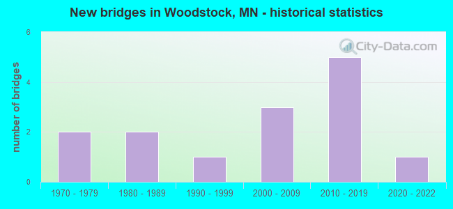
- New bridges - historical statistics
- 21970-1979
- 21980-1989
- 11990-1999
- 32000-2009
- 52010-2019
- 12020-2022
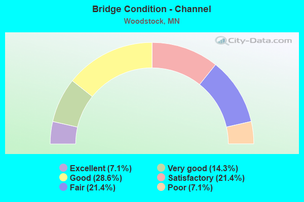
- Bridge Condition - Channel
- 7.1%Excellent
- 14.3%Very good
- 28.6%Good
- 21.4%Satisfactory
- 21.4%Fair
- 7.1%Poor
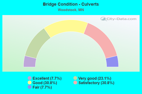
- Bridge Condition - Culverts
- 7.7%Excellent
- 23.1%Very good
- 30.8%Good
- 30.8%Satisfactory
- 7.7%Fair
Find on map >> Show street view
Structure Number: 51J52, Location: 0.2 MI E OF JCT 10TH AVE (Lat: 43.964417, Lng: -96.040489), Route carried "on" structure: County highway 231, Year Built: 2017, Status: Open, Structure Length: 0.91m (2.99ft), Average Daily Traffic: 33 (year 2017), Average Future Daily Traffic: 40 (year 2037), Design Load: HL 93, Features Intersected: CHANARAMBIE CREEK
Minimum Vertical Clearance: 30+ m (98+ ft), Kilometerpoint: 0.000, Lanes on structure: 2, Owner: Town or Township Highway Agency, Approaching Roadway Width: 7.3m (24.0ft), Material/Design: Concrete, Design/Construction: Culvert, Number Of Spans In Main Unit: 2, Length of Maximum Span: 4.3m (14.1ft)
Condition: Channel: Very good, Culverts: Very good, Operating Rating: 42.1 metric tons, Method Used To Determine Operating Rating: Assigned ratings based on Load and Resistance Factor Design (LRFD) reported by rating factor (RF) using HL93 loadings, Inventory Rating: 32.4 metric tons, Method Used To Determine Inventory Rating: Assigned ratings based on Load and Resistance Factor Design (LRFD) reported by rating factor (RF) using HL93 loadings, Structural Evaluation: Equal to present desirable criteria, Waterway Adequacy: Equal to present desirable criteria, Approach Roadway Alignment: Equal to present desirable criteria, Designated Inspection Frequency: Every 48 months, Inspection Date: October 2018
Find on map >> Show street view
Structure Number: 59527, Location: 1.1 MI W JCT TWP 266 (Lat: 44.022892, Lng: -96.147597), Route carried "on" structure: County highway 33, Year Built: 2007, Status: Open, Structure Length: 3.21m (10.53ft), Average Daily Traffic: 24 (year 2006), Average Future Daily Traffic: 24 (year 2029), Design Load: HL 93, Features Intersected: E BR ROCK RIVER
Minimum Vertical Clearance: 30+ m (98+ ft), Kilometerpoint: 0.000, Lanes on structure: 2, Owner: Town or Township Highway Agency, Approaching Roadway Width: 8.8m (28.9ft), Skew: 2 degrees, Material/Design: Concrete continuous, Design/Construction: Slab, Number Of Spans In Main Unit: 3, Length of Maximum Span: 12.2m (40.0ft), Curb-To-Curb Width: 8.5m (27.9ft), Out-to-Out Width: 9.5m (31.2ft)
Condition: Deck: Good, Superstructure: Good, Substructure: Good, Channel: Satisfactory, Operating Rating: 71.2 metric tons, Method Used To Determine Operating Rating: Load Factor (LF), Inventory Rating: 42.6 metric tons, Method Used To Determine Inventory Rating: Load Factor (LF), Structural Evaluation: Better than present minimum criteria, Deck Geometry: Better than present minimum criteria, Waterway Adequacy: Superior to present desirable criteria, Approach Roadway Alignment: Better than present minimum criteria, Designated Inspection Frequency: Every 24 months, Inspection Date: May 2020, Deck Structure Type: Concrete Cast-file-Place, Wearing Surface/Protective System: Wearing Surface: Monolithic Concrete, Deck Protection: Epoxy Coated Reinforcing
Find on map >> Show street view
Structure Number: 59J24, Location: 0.9 MI W OF JCT CSAH 18 (Lat: 44.037369, Lng: -96.122086), Route carried "on" structure: County highway 6, Year Built: 2003, Status: Open, Structure Length: 1.25m (4.10ft), Average Daily Traffic: 205 (year 2016), Average Future Daily Traffic: 205 (year 2039), Design Load: HS 25 or greater, Features Intersected: E BR ROCK RIVER
Minimum Vertical Clearance: 30+ m (98+ ft), Kilometerpoint: 0.000, Lanes on structure: 2, Owner: County Highway Agency, Approaching Roadway Width: 9.8m (32.2ft), Material/Design: Concrete, Design/Construction: Culvert, Number Of Spans In Main Unit: 3, Length of Maximum Span: 3.7m (12.1ft)
Condition: Channel: Satisfactory, Culverts: Satisfactory, Operating Rating: 58.8 metric tons, Method Used To Determine Operating Rating: Assigned rating based on Load Factor Design (LFD) reported in metric tons, Inventory Rating: 39.2 metric tons, Method Used To Determine Inventory Rating: Assigned rating based on Load Factor Design (LFD) reported in metric tons, Structural Evaluation: Equal to present minimum criteria, Waterway Adequacy: Equal to present minimum criteria, Approach Roadway Alignment: Equal to present desirable criteria, Designated Inspection Frequency: Every 48 months, Inspection Date: August 2021
Find on map >> Show street view
Structure Number: 59J42, Location: 0.2 MI W OF JCT CSAH 18 (Lat: 44.051881, Lng: -96.108947), Route carried "on" structure: County highway 44, Year Built: 2006, Status: Open, Structure Length: 0.91m (2.99ft), Average Daily Traffic: 30 (year 2005), Average Future Daily Traffic: 36 (year 2025), Design Load: HS 25 or greater, Features Intersected: E BR ROCK RIVER
Minimum Vertical Clearance: 30+ m (98+ ft), Kilometerpoint: 0.000, Lanes on structure: 2, Owner: Town or Township Highway Agency, Approaching Roadway Width: 7.3m (24.0ft), Material/Design: Concrete, Design/Construction: Culvert, Number Of Spans In Main Unit: 2, Length of Maximum Span: 4.3m (14.1ft)
Condition: Channel: Good, Culverts: Good, Operating Rating: 58.8 metric tons, Method Used To Determine Operating Rating: Assigned rating based on Load Factor Design (LFD) reported in metric tons, Inventory Rating: 39.2 metric tons, Method Used To Determine Inventory Rating: Assigned rating based on Load Factor Design (LFD) reported in metric tons, Structural Evaluation: Better than present minimum criteria, Waterway Adequacy: Better than present minimum criteria, Approach Roadway Alignment: Equal to present desirable criteria, Designated Inspection Frequency: Every 48 months, Inspection Date: August 2020
Find on map >> Show street view
Structure Number: 59J6, Location: 0.9 MI W OF JCT CSAH 18 (Lat: 43.964694, Lng: -96.121361), Route carried "on" structure: County highway 265, Year Built: 2012, Status: Open, Structure Length: 1.39m (4.56ft), Average Daily Traffic: 63 (year 2011), Average Future Daily Traffic: 76 (year 2031), Design Load: HS 25 or greater, Features Intersected: TRIB ROCK RIVER
Minimum Vertical Clearance: 30+ m (98+ ft), Kilometerpoint: 0.000, Lanes on structure: 2, Owner: Town or Township Highway Agency, Approaching Roadway Width: 8.5m (27.9ft), Material/Design: Concrete, Design/Construction: Culvert, Number Of Spans In Main Unit: 3, Length of Maximum Span: 4.3m (14.1ft)
Condition: Channel: Poor, Culverts: Satisfactory, Operating Rating: 58.8 metric tons, Method Used To Determine Operating Rating: Assigned ratings based on Load and Resistance Factor Design (LRFD) reported in metric tons, Inventory Rating: 39.2 metric tons, Method Used To Determine Inventory Rating: Assigned ratings based on Load and Resistance Factor Design (LRFD) reported in metric tons, Structural Evaluation: Equal to present minimum criteria, Waterway Adequacy: Equal to present desirable criteria, Approach Roadway Alignment: Equal to present desirable criteria, Designated Inspection Frequency: Every 24 months, Inspection Date: July 2020
Find on map >> Show street view
Structure Number: 59J91, Location: 0.1 MI E OF JCT TWP 284 (Lat: 44.037411, Lng: -96.143433), Route carried "on" structure: County highway 6, Year Built: 2014, Status: Open, Structure Length: 1.77m (5.81ft), Average Daily Traffic: 205 (year 2016), Average Future Daily Traffic: 205 (year 2039), Design Load: HL 93, Features Intersected: E BR ROCK RIVER
Minimum Vertical Clearance: 30+ m (98+ ft), Kilometerpoint: 0.000, Lanes on structure: 2, Owner: County Highway Agency, Approaching Roadway Width: 10.4m (34.1ft), Material/Design: Concrete, Design/Construction: Culvert, Number Of Spans In Main Unit: 3, Length of Maximum Span: 5.5m (18.0ft)
Condition: Channel: Very good, Culverts: Good, Operating Rating: 42.1 metric tons, Method Used To Determine Operating Rating: Assigned ratings based on Load and Resistance Factor Design (LRFD) reported by rating factor (RF) using HL93 loadings, Inventory Rating: 32.4 metric tons, Method Used To Determine Inventory Rating: Assigned ratings based on Load and Resistance Factor Design (LRFD) reported by rating factor (RF) using HL93 loadings, Structural Evaluation: Better than present minimum criteria, Waterway Adequacy: Equal to present desirable criteria, Approach Roadway Alignment: Equal to present desirable criteria, Designated Inspection Frequency: Every 48 months, Inspection Date: September 2020
Find on map >> Show street view
Structure Number: 59J93, Location: 0.5 MI W OF JCT CSAH 18 (Lat: 44.037350, Lng: -96.116050), Route carried "on" structure: County highway 6, Year Built: 2014, Status: Open, Structure Length: 1.77m (5.81ft), Average Daily Traffic: 205 (year 2016), Average Future Daily Traffic: 205 (year 2039), Design Load: HL 93, Features Intersected: E BR ROCK RIVER
Minimum Vertical Clearance: 30+ m (98+ ft), Kilometerpoint: 0.000, Lanes on structure: 2, Owner: County Highway Agency, Approaching Roadway Width: 10.4m (34.1ft), Material/Design: Concrete, Design/Construction: Culvert, Number Of Spans In Main Unit: 3, Length of Maximum Span: 5.5m (18.0ft)
Condition: Channel: Good, Culverts: Good, Operating Rating: 42.1 metric tons, Method Used To Determine Operating Rating: Assigned ratings based on Load and Resistance Factor Design (LRFD) reported by rating factor (RF) using HL93 loadings, Inventory Rating: 32.4 metric tons, Method Used To Determine Inventory Rating: Assigned ratings based on Load and Resistance Factor Design (LRFD) reported by rating factor (RF) using HL93 loadings, Structural Evaluation: Better than present minimum criteria, Waterway Adequacy: Equal to present desirable criteria, Approach Roadway Alignment: Equal to present desirable criteria, Designated Inspection Frequency: Every 48 months, Inspection Date: August 2020
Find on map >> Show street view
Structure Number: 59J96, Location: 1.1 MI E OF JCT CSAH 18 (Lat: 43.950078, Lng: -96.082561), Route carried "on" structure: County highway 3, Year Built: 2019, Status: Open, Structure Length: 0.84m (2.76ft), Average Daily Traffic: 156 (year 2019), Average Future Daily Traffic: 203 (year 2039), Features Intersected: TRIB ROCK RIVER
Minimum Vertical Clearance: 30+ m (98+ ft), Kilometerpoint: 0.000, Lanes on structure: 2, Owner: County Highway Agency, Approaching Roadway Width: 10.4m (34.1ft), Material/Design: Concrete, Design/Construction: Culvert, Number Of Spans In Main Unit: 2, Length of Maximum Span: 3.9m (12.8ft)
Condition: Channel: Good, Culverts: Very good, Operating Rating: 53.9 metric tons, Method Used To Determine Operating Rating: Assigned ratings based on Allowable Stress Design (ASD) reported in metric tons, Inventory Rating: 35.9 metric tons, Method Used To Determine Inventory Rating: Assigned ratings based on Allowable Stress Design (ASD) reported in metric tons, Structural Evaluation: Equal to present desirable criteria, Waterway Adequacy: Superior to present desirable criteria, Approach Roadway Alignment: Equal to present minimum criteria, Designated Inspection Frequency: Every 48 months, Inspection Date: September 2020
Find on map >> Show street view
Structure Number: 59K18, Location: 0.5 MI N OF JCT TWP 265 (Lat: 43.971708, Lng: -96.104089), Route carried "on" structure: County highway 18, Year Built: 2020, Status: Open, Structure Length: 1.18m (3.87ft), Average Daily Traffic: 742 (year 2019), Average Future Daily Traffic: 965 (year 2039), Design Load: HS 20, Features Intersected: TRIB TO ROCK RIVER
Minimum Vertical Clearance: 30+ m (98+ ft), Kilometerpoint: 0.000, Lanes on structure: 2, Owner: County Highway Agency, Approaching Roadway Width: 13.4m (44.0ft), Material/Design: Concrete, Design/Construction: Culvert, Number Of Spans In Main Unit: 3, Length of Maximum Span: 3.5m (11.5ft)
Condition: Channel: Excellent, Culverts: Excellent, Operating Rating: 53.9 metric tons, Method Used To Determine Operating Rating: Assigned ratings based on Allowable Stress Design (ASD) reported in metric tons, Inventory Rating: 35.9 metric tons, Method Used To Determine Inventory Rating: Assigned ratings based on Allowable Stress Design (ASD) reported in metric tons, Structural Evaluation: Superior to present desirable criteria, Waterway Adequacy: Equal to present desirable criteria, Approach Roadway Alignment: Equal to present desirable criteria, Designated Inspection Frequency: Every 48 months, Inspection Date: October 2020
Find on map >> Show street view
Structure Number: 91759, Location: 0.5 MI S OF JCT CSAH 6 (Lat: 44.029708, Lng: -96.104622), Route carried "on" structure: County highway 18, Year Built: 1979, Status: Open, Structure Length: 1.02m (3.35ft), Average Daily Traffic: 630 (year 2016), Average Future Daily Traffic: 630 (year 2039), Design Load: HS 20, Features Intersected: TRIB E BR ROCK RIVER
Minimum Vertical Clearance: 30+ m (98+ ft), Kilometerpoint: 0.000, Lanes on structure: 2, Owner: County Highway Agency, Approaching Roadway Width: 12.2m (40.0ft), Material/Design: Concrete, Design/Construction: Culvert, Number Of Spans In Main Unit: 2, Length of Maximum Span: 3.9m (12.8ft)
Condition: Channel: Satisfactory, Culverts: Fair, Operating Rating: 39.2 metric tons, Method Used To Determine Operating Rating: Assigned ratings based on Allowable Stress Design (ASD) reported in metric tons, Inventory Rating: 29.4 metric tons, Method Used To Determine Inventory Rating: Assigned ratings based on Allowable Stress Design (ASD) reported in metric tons, Structural Evaluation: Somewhat better than minimum adequacy, Waterway Adequacy: Equal to present desirable criteria, Approach Roadway Alignment: Equal to present desirable criteria, Designated Inspection Frequency: Every 24 months, Inspection Date: July 2020
Find on map >> Show street view
Structure Number: 9176, Location: 0.6 MI S OF JCT CSAH 7 (Lat: 44.058369, Lng: -96.104447), Route carried "on" structure: County highway 18, Year Built: 1979, Status: Open, Structure Length: 0.72m (2.36ft), Average Daily Traffic: 630 (year 2016), Average Future Daily Traffic: 630 (year 2039), Design Load: HS 20, Features Intersected: TRIB E BR ROCK RIVER
Minimum Vertical Clearance: 30+ m (98+ ft), Kilometerpoint: 0.000, Lanes on structure: 2, Owner: County Highway Agency, Approaching Roadway Width: 12.2m (40.0ft), Material/Design: Concrete, Design/Construction: Culvert, Number Of Spans In Main Unit: 2, Length of Maximum Span: 2.9m (9.5ft)
Condition: Channel: Fair, Culverts: Satisfactory, Operating Rating: 39.2 metric tons, Method Used To Determine Operating Rating: Assigned ratings based on Allowable Stress Design (ASD) reported in metric tons, Inventory Rating: 29.4 metric tons, Method Used To Determine Inventory Rating: Assigned ratings based on Allowable Stress Design (ASD) reported in metric tons, Structural Evaluation: Equal to present minimum criteria, Waterway Adequacy: Equal to present desirable criteria, Approach Roadway Alignment: Better than present minimum criteria, Designated Inspection Frequency: Every 24 months, Inspection Date: May 2020
Find on map >> Show street view
Structure Number: 95556, Location: 0.2 MI E OF JCT CSAH 18 (Lat: 43.979164, Lng: -96.100617), Route carried "on" structure: County highway 29, Year Built: 1981, Status: Open, Structure Length: 0.96m (3.15ft), Average Daily Traffic: 22 (year 1986), Average Future Daily Traffic: 22 (year 2029), Design Load: HS 20, Features Intersected: TRIB ROCK RIVER
Minimum Vertical Clearance: 30+ m (98+ ft), Kilometerpoint: 0.000, Lanes on structure: 2, Owner: Town or Township Highway Agency, Approaching Roadway Width: 7.3m (24.0ft), Skew: 1 degrees, Material/Design: Concrete, Design/Construction: Culvert, Number Of Spans In Main Unit: 2, Length of Maximum Span: 3.6m (11.8ft)
Condition: Channel: Fair, Culverts: Satisfactory, Operating Rating: 39.2 metric tons, Method Used To Determine Operating Rating: Assigned ratings based on Allowable Stress Design (ASD) reported in metric tons, Inventory Rating: 29.4 metric tons, Method Used To Determine Inventory Rating: Assigned ratings based on Allowable Stress Design (ASD) reported in metric tons, Structural Evaluation: Equal to present minimum criteria, Waterway Adequacy: Equal to present desirable criteria, Approach Roadway Alignment: Equal to present desirable criteria, Designated Inspection Frequency: Every 24 months, Inspection Date: May 2020
Find on map >> Show street view
Structure Number: 96606, Location: 0.2 MI S OF JCT CSAH 3 (Lat: 43.947269, Lng: -96.084053), Route carried "on" structure: County highway 51, Year Built: 1992, Status: Open, Structure Length: 0.66m (2.17ft), Average Daily Traffic: 33 (year 1992), Average Future Daily Traffic: 33 (year 2029), Design Load: HS 25 or greater, Features Intersected: TRIB ROCK RIVER
Minimum Vertical Clearance: 30+ m (98+ ft), Kilometerpoint: 0.000, Lanes on structure: 2, Owner: Town or Township Highway Agency, Approaching Roadway Width: 7.3m (24.0ft), Material/Design: Concrete, Design/Construction: Culvert, Number Of Spans In Main Unit: 2, Length of Maximum Span: 2.4m (7.9ft)
Condition: Channel: Fair, Culverts: Good, Operating Rating: 58.8 metric tons, Method Used To Determine Operating Rating: Assigned rating based on Load Factor Design (LFD) reported in metric tons, Inventory Rating: 39.2 metric tons, Method Used To Determine Inventory Rating: Assigned rating based on Load Factor Design (LFD) reported in metric tons, Structural Evaluation: Better than present minimum criteria, Waterway Adequacy: Better than present minimum criteria, Approach Roadway Alignment: Better than present minimum criteria, Designated Inspection Frequency: Every 24 months, Inspection Date: September 2020
Find on map >> Show street view
Structure Number: L9937, Location: 1.8 MI S OF JCT TH30 (Lat: 43.967164, Lng: -96.043861), Route carried "on" structure: County highway 116, Year Built: 1980, Status: Open, Structure Length: 0.91m (2.99ft), Average Daily Traffic: 36 (year 1990), Average Future Daily Traffic: 36 (year 2029), Design Load: HS 20, Features Intersected: CHANARAMBIE CREEK
Minimum Vertical Clearance: 30+ m (98+ ft), Kilometerpoint: 0.000, Lanes on structure: 2, Owner: Town or Township Highway Agency, Approaching Roadway Width: 7.3m (24.0ft), Skew: 1 degrees, Material/Design: Concrete, Design/Construction: Culvert, Number Of Spans In Main Unit: 2, Length of Maximum Span: 3.5m (11.5ft)
Condition: Channel: Good, Culverts: Very good, Operating Rating: 53.9 metric tons, Method Used To Determine Operating Rating: Assigned ratings based on Allowable Stress Design (ASD) reported in metric tons, Inventory Rating: 35.9 metric tons, Method Used To Determine Inventory Rating: Assigned ratings based on Allowable Stress Design (ASD) reported in metric tons, Structural Evaluation: Equal to present desirable criteria, Waterway Adequacy: Equal to present desirable criteria, Approach Roadway Alignment: Equal to present desirable criteria, Designated Inspection Frequency: Every 48 months, Inspection Date: October 2018