Bridge Statistics for Worcester, New York (NY)
Condition, Traffic, Stress, Structural Evaluation, Project Costs
- National Bridge Inventory (NBI) Statistics
- 29Number of bridges
- 262ft / 80.0mTotal length
- $43,172,000Total costs
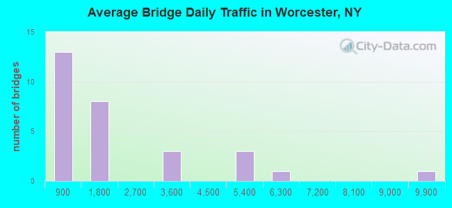
- 52,839Total average daily traffic
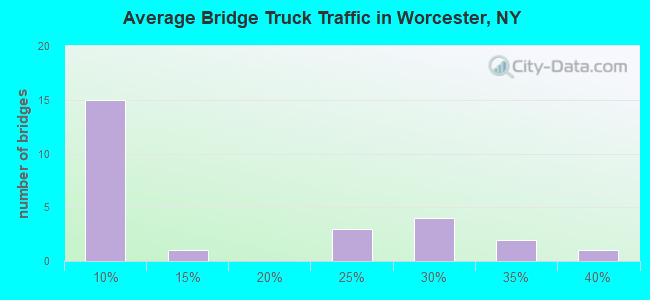
- 11,588Total average daily truck traffic
- National Bridge Inventory (NBI) Registered Bridges for Worcester
- No street view available for this location
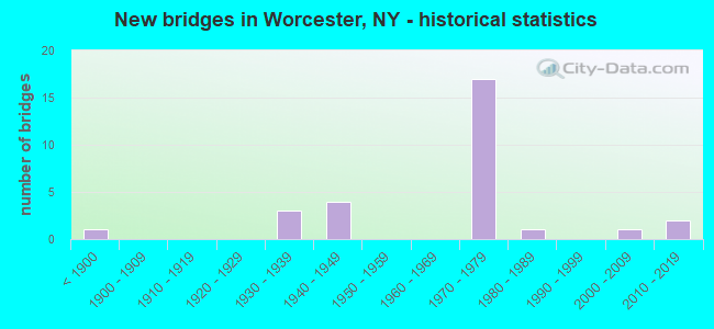
- New bridges - historical statistics
- 1Before 1900
- 31930-1939
- 41940-1949
- 171970-1979
- 11980-1989
- 12000-2009
- 22010-2019
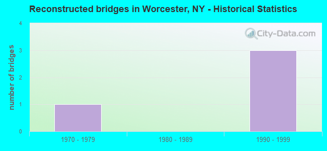
- Reconstructed bridges - Historical Statistics
- 11970-1979
- 01980-1989
- 31990-1999
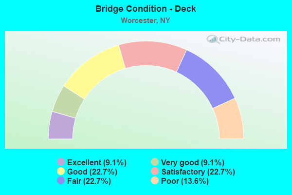
- Bridge Condition - Deck
- 9.1%Excellent
- 9.1%Very good
- 22.7%Good
- 22.7%Satisfactory
- 22.7%Fair
- 13.6%Poor
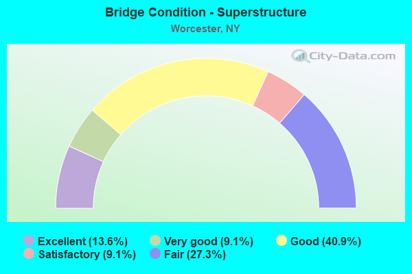
- Bridge Condition - Superstructure
- 13.6%Excellent
- 9.1%Very good
- 40.9%Good
- 9.1%Satisfactory
- 27.3%Fair
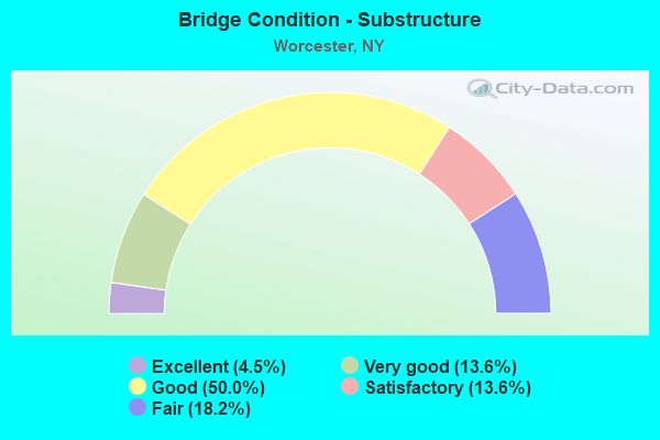
- Bridge Condition - Substructure
- 4.5%Excellent
- 13.6%Very good
- 50.0%Good
- 13.6%Satisfactory
- 18.2%Fair
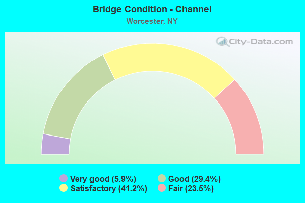
- Bridge Condition - Channel
- 5.9%Very good
- 29.4%Good
- 41.2%Satisfactory
- 23.5%Fair
Find on map >> Show street view
Structure Number: 100401, Location: AT WORCESTER (Lat: 42.591303, Lng: -74.753833), Route carried "on" structure: State highway 7, Year Built: 1937, Status: Open, Structure Length: 1.25m (4.10ft), Average Daily Traffic: 1,328 (year 2020), Truck Traffic: 8%, Average Future Daily Traffic: 1,385 (year 2040), Features Intersected: Decatur Creek
Minimum Vertical Clearance: 30+ m (98+ ft), Kilometerpoint: 70.056, Lanes on structure: 2, Base Highway Network: Yes, Owner: State Highway Agency, Approaching Roadway Width: 9.1m (29.9ft), Material/Design: Steel, Design/Construction: Stringer/Multi-beam, Number Of Spans In Main Unit: 1, Length of Maximum Span: 12.2m (40.0ft), Curb or Sidewalk Widths: Left: 1.5m (4.9ft), Right: 1.5m (4.9ft), Curb-To-Curb Width: 9.1m (29.9ft), Out-to-Out Width: 12.9m (42.3ft)
Condition: Deck: Fair, Superstructure: Fair, Substructure: Satisfactory, Channel: Good, Operating Rating: 59.9 metric tons, Method Used To Determine Operating Rating: Load Factor (LF), Inventory Rating: 35.4 metric tons, Method Used To Determine Inventory Rating: Load Factor (LF), Structural Evaluation: Somewhat better than minimum adequacy, Deck Geometry: Somewhat better than minimum adequacy, Waterway Adequacy: Somewhat better than minimum adequacy, Approach Roadway Alignment: Equal to present minimum criteria, Length Of Structure Improvement: 1.24m (4.07ft), Designated Inspection Frequency: Every 24 months, Inspection Date: September 2021, Bridge Improvement Cost: $566,000, Roadway Improvement Cost: $332,000, Total Project Cost: $898,000 ( Estimate for 2021), Deck Structure Type: Concrete Cast-file-Place, Wearing Surface/Protective System: Wearing Surface: Bituminous
Find on map >> Show street view
Structure Number: 100402, Location: 1 MI W OF EAST WORCESTER (Lat: 42.612197, Lng: -74.687333), Route carried "on" structure: State highway 7, Year Built: 1940, Status: Open, Structure Length: 0.82m (2.69ft), Average Daily Traffic: 1,100 (year 2020), Truck Traffic: 9%, Average Future Daily Traffic: 1,147 (year 2040), Design Load: H 20, Features Intersected: W HILL ROAD CREEK
Minimum Vertical Clearance: 30+ m (98+ ft), Kilometerpoint: 76.202, Lanes on structure: 2, Base Highway Network: Yes, Owner: State Highway Agency, Approaching Roadway Width: 8.5m (27.9ft), Skew: 1 degrees, Material/Design: Concrete, Design/Construction: Slab, Number Of Spans In Main Unit: 1, Length of Maximum Span: 7.3m (24.0ft), Curb-To-Curb Width: 10.7m (35.1ft), Out-to-Out Width: 11.6m (38.1ft)
Condition: Deck: Satisfactory, Superstructure: Satisfactory, Substructure: Satisfactory, Channel: Satisfactory, Operating Rating: 30.1 metric tons, Method Used To Determine Operating Rating: Load and Resistance Factor Rating (LRFR) rating reported by rating factor(RF) method using HL-93 loadings, Inventory Rating: 23.3 metric tons, Method Used To Determine Inventory Rating: Load and Resistance Factor Rating (LRFR) rating reported by rating factor(RF) method using HL-93 loadings, Structural Evaluation: Equal to present minimum criteria, Deck Geometry: Equal to present minimum criteria, Waterway Adequacy: Meets minimum limits, Approach Roadway Alignment: Equal to present minimum criteria, Length Of Structure Improvement: 0.82m (2.69ft), Designated Inspection Frequency: Every 24 months, Inspection Date: June 2021, Bridge Improvement Cost: $352,000, Roadway Improvement Cost: $206,000, Total Project Cost: $559,000 ( Estimate for 2021), Wearing Surface/Protective System: Wearing Surface: Bituminous
Find on map >> Show street view
Structure Number: 100403, Location: AT EAST WORCESTER (Lat: 42.621650, Lng: -74.674664), Route carried "on" structure: State highway 7, Year Built: 1940, Status: Open, Structure Length: 1.58m (5.18ft), Average Daily Traffic: 1,100 (year 2020), Truck Traffic: 9%, Average Future Daily Traffic: 1,147 (year 2040), Features Intersected: OAK CREEK
Minimum Vertical Clearance: 30+ m (98+ ft), Kilometerpoint: 77.683, Lanes on structure: 2, Base Highway Network: Yes, Owner: State Highway Agency, Approaching Roadway Width: 8.5m (27.9ft), Skew: 4 degrees, Material/Design: Steel, Design/Construction: Stringer/Multi-beam, Number Of Spans In Main Unit: 1, Length of Maximum Span: 15.5m (50.9ft), Curb or Sidewalk Widths: Left: 1.5m (4.9ft), Right: 1.5m (4.9ft), Curb-To-Curb Width: 7.9m (25.9ft), Out-to-Out Width: 11.8m (38.7ft)
Condition: Deck: Fair, Superstructure: Fair, Substructure: Fair, Channel: Satisfactory, Operating Rating: 52.6 metric tons, Method Used To Determine Operating Rating: Load Factor (LF), Inventory Rating: 31.8 metric tons, Method Used To Determine Inventory Rating: Load Factor (LF), Structural Evaluation: Somewhat better than minimum adequacy, Deck Geometry: Meets minimum limits, Waterway Adequacy: Meets minimum limits, Approach Roadway Alignment: Equal to present desirable criteria, Length Of Structure Improvement: 1.58m (5.18ft), Designated Inspection Frequency: Every 24 months, Inspection Date: July 2021, Bridge Improvement Cost: $648,000, Roadway Improvement Cost: $380,000, Total Project Cost: $1,028,000 ( Estimate for 2021), Deck Structure Type: Concrete Cast-file-Place, Wearing Surface/Protective System: Wearing Surface: Bituminous, Membrane: Preformed Fabric
Find on map >> Show street view
Structure Number: 100405, Location: .6 MI W OF SCHOHARIE C LN (Lat: 42.645144, Lng: -74.647081), Route carried "on" structure: State highway 7, Year Built: 2017, Status: Open, Structure Length: 6.58m (21.59ft), Average Daily Traffic: 916 (year 2020), Truck Traffic: 11%, Average Future Daily Traffic: 955 (year 2040), Design Load: HL 93, Features Intersected: NORFOLK SOUTHERN
Minimum Vertical Clearance: 30+ m (98+ ft), Kilometerpoint: 81.142, Lanes on structure: 2, Base Highway Network: Yes, Owner: State Highway Agency, Approaching Roadway Width: 9.8m (32.2ft), Skew: 3 degrees, Material/Design: Steel, Design/Construction: Stringer/Multi-beam, Number Of Spans In Main Unit: 1, Length of Maximum Span: 64.0m (210.0ft), Curb-To-Curb Width: 9.8m (32.2ft), Out-to-Out Width: 10.7m (35.1ft)
Condition: Deck: Excellent, Superstructure: Excellent, Substructure: Very good, Operating Rating: 68.9 metric tons, Method Used To Determine Operating Rating: Load Factor (LF), Inventory Rating: 41.7 metric tons, Method Used To Determine Inventory Rating: Load Factor (LF), Structural Evaluation: Equal to present desirable criteria, Deck Geometry: Equal to present minimum criteria, Underclear: Superior to present desirable criteria, Approach Roadway Alignment: Better than present minimum criteria, Length Of Structure Improvement: 6.58m (21.59ft), Designated Inspection Frequency: Every 24 months, Inspection Date: November 2021, Bridge Improvement Cost: $2,384,000, Roadway Improvement Cost: $1,396,000, Total Project Cost: $3,780,000 ( Estimate for 2021), Deck Structure Type: Concrete Cast-file-Place, Wearing Surface/Protective System: Wearing Surface: Integral Concrete, Deck Protection: Epoxy Coated Reinforcing
Find on map >> Show street view
Structure Number: 10544, Location: 1.6 MI E OF WORCESTER (Lat: 42.595906, Lng: -74.719344), Route carried "on" structure: State highway 7, Year Built: 1940, Status: Open, Structure Length: 1.16m (3.81ft), Average Daily Traffic: 1,100 (year 2020), Truck Traffic: 9%, Average Future Daily Traffic: 1,147 (year 2040), Design Load: HS 20+Mod, Features Intersected: SMALL CREEK
Minimum Vertical Clearance: 30+ m (98+ ft), Kilometerpoint: 72.984, Lanes on structure: 2, Base Highway Network: Yes, Owner: State Highway Agency, Approaching Roadway Width: 10.1m (33.1ft), Skew: 6 degrees, Material/Design: Concrete, Design/Construction: Culvert, Number Of Spans In Main Unit: 1, Length of Maximum Span: 9.1m (29.9ft)
Condition: Channel: Fair, Culverts: Satisfactory, Operating Rating: 97.2 metric tons, Method Used To Determine Operating Rating: Load and Resistance Factor Rating (LRFR) rating reported by rating factor(RF) method using HL-93 loadings, Inventory Rating: 94.9 metric tons, Method Used To Determine Inventory Rating: Load and Resistance Factor Rating (LRFR) rating reported by rating factor(RF) method using HL-93 loadings, Structural Evaluation: Equal to present minimum criteria, Waterway Adequacy: Meets minimum limits, Approach Roadway Alignment: Equal to present desirable criteria, Length Of Structure Improvement: 1.15m (3.77ft), Designated Inspection Frequency: Every 24 months, Inspection Date: May 2021, Bridge Improvement Cost: $206,000, Roadway Improvement Cost: $121,000, Total Project Cost: $327,000 ( Estimate for 2021), Wearing Surface/Protective System: Wearing Surface: Integral Concrete
Find on map >> Show street view
Structure Number: 1069871, Location: .3 MI SOUTH OF WORCESTER (Lat: 42.586514, Lng: -74.749917), Route carried "on" structure: Interstate 88, Year Built: 1979, Status: Open, Structure Length: 3.66m (12.01ft), Average Daily Traffic: 4,836 (year 2011), Truck Traffic: 28%, Design Load: HS 20+Mod, Features Intersected: SO HILL ROAD/CR39
Minimum Vertical Clearance: 30+ m (98+ ft), Kilometerpoint: 46.613, Lanes on structure: 2, Lanes under structure: 2, Base Highway Network: Yes, Owner: State Highway Agency, Approaching Roadway Width: 12.5m (41.0ft), Skew: 2 degrees, Material/Design: Steel, Design/Construction: Stringer/Multi-beam, Number Of Spans In Main Unit: 1, Length of Maximum Span: 35.3m (115.8ft), Curb-To-Curb Width: 12.5m (41.0ft), Out-to-Out Width: 13.4m (44.0ft)
Condition: Deck: Good, Superstructure: Good, Substructure: Good, Operating Rating: 59.6 metric tons, Method Used To Determine Operating Rating: Load and Resistance Factor Rating (LRFR) rating reported by rating factor(RF) method using HL-93 loadings, Inventory Rating: 46.0 metric tons, Method Used To Determine Inventory Rating: Load and Resistance Factor Rating (LRFR) rating reported by rating factor(RF) method using HL-93 loadings, Structural Evaluation: Better than present minimum criteria, Deck Geometry: Better than present minimum criteria, Underclear: Meets minimum limits, Approach Roadway Alignment: Equal to present desirable criteria, Length Of Structure Improvement: 3.65m (11.98ft), Designated Inspection Frequency: Every 24 months, Inspection Date: March 2021, Bridge Improvement Cost: $1,265,000, Roadway Improvement Cost: $741,000, Total Project Cost: $2,005,000 ( Estimate for 2021), Deck Structure Type: Concrete Cast-file-Place, Wearing Surface/Protective System: Wearing Surface: Epoxy Overlay, Deck Protection: Epoxy Coated Reinforcing
Find on map >> Show street view
Structure Number: 1069872, Location: .3 MI SOUTH OF WORCHESTER (Lat: 42.586139, Lng: -74.750117), Route carried "on" structure: Interstate 88, Year Built: 1979, Status: Open, Structure Length: 4.21m (13.81ft), Average Daily Traffic: 3,306 (year 2020), Truck Traffic: 37%, Average Future Daily Traffic: 3,937 (year 2040), Design Load: HS 20+Mod, Features Intersected: SO HILL ROAD CR39
Minimum Vertical Clearance: 30+ m (98+ ft), Kilometerpoint: 46.629, Lanes on structure: 2, Lanes under structure: 2, Base Highway Network: Yes, Owner: State Highway Agency, Approaching Roadway Width: 12.5m (41.0ft), Skew: 3 degrees, Material/Design: Steel, Design/Construction: Stringer/Multi-beam, Number Of Spans In Main Unit: 1, Length of Maximum Span: 40.5m (132.9ft), Curb-To-Curb Width: 12.5m (41.0ft), Out-to-Out Width: 13.4m (44.0ft)
Condition: Deck: Good, Superstructure: Good, Substructure: Good, Operating Rating: 53.1 metric tons, Method Used To Determine Operating Rating: Load and Resistance Factor Rating (LRFR) rating reported by rating factor(RF) method using HL-93 loadings, Inventory Rating: 40.8 metric tons, Method Used To Determine Inventory Rating: Load and Resistance Factor Rating (LRFR) rating reported by rating factor(RF) method using HL-93 loadings, Structural Evaluation: Better than present minimum criteria, Deck Geometry: Better than present minimum criteria, Underclear: Meets minimum limits, Approach Roadway Alignment: Equal to present desirable criteria, Length Of Structure Improvement: 4.20m (13.78ft), Designated Inspection Frequency: Every 24 months, Inspection Date: March 2021, Bridge Improvement Cost: $1,463,000, Roadway Improvement Cost: $857,000, Total Project Cost: $2,319,000 ( Estimate for 2021), Deck Structure Type: Concrete Cast-file-Place, Wearing Surface/Protective System: Wearing Surface: Epoxy Overlay, Deck Protection: Epoxy Coated Reinforcing
Find on map >> Show street view
Structure Number: 106988, Location: 0.6 MI E OF WORCHESTER (Lat: 42.593158, Lng: -74.728208), Route carried "on" structure: Ramp Interstate 88, Year Built: 1979, Status: Open, Structure Length: 4.69m (15.39ft), Average Daily Traffic: 209 (year 2015), Truck Traffic: 31%, Average Future Daily Traffic: 248 (year 2040), Design Load: HS 20+Mod, Features Intersected: SCHENEVUS CREEK
Minimum Vertical Clearance: 30+ m (98+ ft), Kilometerpoint: 0.515, Lanes on structure: 1, Owner: State Highway Agency, Approaching Roadway Width: 7.6m (24.9ft), Skew: 1 degrees, Material/Design: Steel, Design/Construction: Stringer/Multi-beam, Number Of Spans In Main Unit: 1, Length of Maximum Span: 45.7m (149.9ft), Curb-To-Curb Width: 7.6m (24.9ft), Out-to-Out Width: 8.2m (26.9ft)
Condition: Deck: Good, Superstructure: Good, Substructure: Good, Channel: Good, Operating Rating: 56.7 metric tons, Method Used To Determine Operating Rating: Load and Resistance Factor Rating (LRFR) rating reported by rating factor(RF) method using HL-93 loadings, Inventory Rating: 43.7 metric tons, Method Used To Determine Inventory Rating: Load and Resistance Factor Rating (LRFR) rating reported by rating factor(RF) method using HL-93 loadings, Structural Evaluation: Better than present minimum criteria, Deck Geometry: Better than present minimum criteria, Waterway Adequacy: Equal to present minimum criteria, Approach Roadway Alignment: Equal to present desirable criteria, Length Of Structure Improvement: 4.69m (15.39ft), Designated Inspection Frequency: Every 24 months, Inspection Date: June 2021, Bridge Improvement Cost: $964,000, Roadway Improvement Cost: $564,000, Total Project Cost: $1,528,000 ( Estimate for 2021), Deck Structure Type: Concrete Cast-file-Place, Wearing Surface/Protective System: Wearing Surface: Integral Concrete, Deck Protection: Epoxy Coated Reinforcing
Find on map >> Show street view
Structure Number: 106989, Location: 0.8 MI E OF WORCHESTER (Lat: 42.592611, Lng: -74.725633), Route carried "on" structure: Interstate 992A, Year Built: 1979, Status: Open, Structure Length: 2.80m (9.19ft), Average Daily Traffic: 237 (year 2015), Truck Traffic: 31%, Average Future Daily Traffic: 282 (year 2040), Design Load: HS 20+Mod, Features Intersected: SCHENEVUS CREEK
Minimum Vertical Clearance: 30+ m (98+ ft), Kilometerpoint: 0.161, Lanes on structure: 1, Owner: State Highway Agency, Approaching Roadway Width: 7.6m (24.9ft), Skew: 1 degrees, Material/Design: Prestressed concrete, Design/Construction: Box Beam or Girders - Multiple, Number Of Spans In Main Unit: 1, Length of Maximum Span: 26.8m (87.9ft), Curb-To-Curb Width: 7.6m (24.9ft), Out-to-Out Width: 8.5m (27.9ft)
Condition: Deck: Fair, Superstructure: Fair, Substructure: Good, Channel: Good, Operating Rating: 69.9 metric tons, Method Used To Determine Operating Rating: Load Factor (LF), Inventory Rating: 29.0 metric tons, Method Used To Determine Inventory Rating: Load Factor (LF), Structural Evaluation: Somewhat better than minimum adequacy, Deck Geometry: Somewhat better than minimum adequacy, Waterway Adequacy: Equal to present desirable criteria, Approach Roadway Alignment: Equal to present desirable criteria, Length Of Structure Improvement: 2.80m (9.19ft), Designated Inspection Frequency: Every 24 months, Inspection Date: March 2020, Bridge Improvement Cost: $583,000, Roadway Improvement Cost: $341,000, Total Project Cost: $924,000 ( Estimate for 2021), Wearing Surface/Protective System: Wearing Surface: Monolithic Concrete
Find on map >> Show street view
Structure Number: 107025, Location: 2.0 MI E OF WORCESTER (Lat: 42.593964, Lng: -74.711958), Route carried "on" structure: Interstate 88, Year Built: 1979, Status: Open, Structure Length: 8.53m (27.99ft), Average Daily Traffic: 6,191 (year 2018), Truck Traffic: 27%, Average Future Daily Traffic: 7,373 (year 2040), Design Load: HS 20, Features Intersected: SCHENEVUS CREEK
Minimum Vertical Clearance: 30+ m (98+ ft), Kilometerpoint: 49.911, Lanes on structure: 2, Base Highway Network: Yes, Owner: State Highway Agency, Approaching Roadway Width: 12.8m (42.0ft), Skew: 2 degrees, Material/Design: Steel continuous, Design/Construction: Stringer/Multi-beam, Number Of Spans In Main Unit: 3, Length of Maximum Span: 38.1m (125.0ft), Curb-To-Curb Width: 12.8m (42.0ft), Out-to-Out Width: 13.4m (44.0ft)
Condition: Deck: Satisfactory, Superstructure: Good, Substructure: Good, Channel: Satisfactory, Operating Rating: 36.6 metric tons, Method Used To Determine Operating Rating: Load and Resistance Factor Rating (LRFR) rating reported by rating factor(RF) method using HL-93 loadings, Inventory Rating: 28.2 metric tons, Method Used To Determine Inventory Rating: Load and Resistance Factor Rating (LRFR) rating reported by rating factor(RF) method using HL-93 loadings, Structural Evaluation: Better than present minimum criteria, Deck Geometry: Equal to present desirable criteria, Waterway Adequacy: Equal to present minimum criteria, Approach Roadway Alignment: Equal to present desirable criteria, Length Of Structure Improvement: 8.53m (27.99ft), Designated Inspection Frequency: Every 24 months, Inspection Date: May 2021, Bridge Improvement Cost: $2,650,000, Roadway Improvement Cost: $1,552,000, Total Project Cost: $4,203,000 ( Estimate for 2021), Deck Structure Type: Concrete Cast-file-Place, Wearing Surface/Protective System: Wearing Surface: Epoxy Overlay, Deck Protection: Epoxy Coated Reinforcing
Find on map >> Show street view
Structure Number: 1070711, Location: .7 MI NE OF E WORCESTER (Lat: 42.628689, Lng: -74.660589), Route carried "on" structure: Interstate 88, Year Built: 1979, Status: Open, Structure Length: 3.38m (11.09ft), Average Daily Traffic: 4,836 (year 2011), Truck Traffic: 24%, Design Load: HS 20, Features Intersected: Brooker Hollow Rd
Minimum Vertical Clearance: 30+ m (98+ ft), Kilometerpoint: 55.993, Lanes on structure: 2, Lanes under structure: 2, Base Highway Network: Yes, Owner: State Highway Agency, Approaching Roadway Width: 12.5m (41.0ft), Skew: 2 degrees, Material/Design: Steel, Design/Construction: Stringer/Multi-beam, Number Of Spans In Main Unit: 1, Length of Maximum Span: 32.6m (107.0ft), Curb-To-Curb Width: 12.5m (41.0ft), Out-to-Out Width: 13.4m (44.0ft)
Condition: Deck: Good, Superstructure: Good, Substructure: Very good, Operating Rating: 88.0 metric tons, Method Used To Determine Operating Rating: Load Factor (LF), Inventory Rating: 52.6 metric tons, Method Used To Determine Inventory Rating: Load Factor (LF), Structural Evaluation: Better than present minimum criteria, Deck Geometry: Better than present minimum criteria, Underclear: Somewhat better than minimum adequacy, Approach Roadway Alignment: Equal to present desirable criteria, Length Of Structure Improvement: 3.38m (11.09ft), Designated Inspection Frequency: Every 24 months, Inspection Date: November 2021, Bridge Improvement Cost: $1,266,000, Roadway Improvement Cost: $742,000, Total Project Cost: $2,008,000 ( Estimate for 2021), Deck Structure Type: Concrete Cast-file-Place, Wearing Surface/Protective System: Wearing Surface: Integral Concrete, Deck Protection: Epoxy Coated Reinforcing
Find on map >> Show street view
Structure Number: 1070712, Location: .7 MI NE OF E WORCESTER (Lat: 42.628719, Lng: -74.660222), Route carried "on" structure: Interstate 88, Year Built: 1979, Status: Open, Structure Length: 3.38m (11.09ft), Average Daily Traffic: 3,096 (year 2018), Truck Traffic: 27%, Average Future Daily Traffic: 3,686 (year 2040), Design Load: HS 20, Features Intersected: Brooker Hollow Rd
Minimum Vertical Clearance: 30+ m (98+ ft), Kilometerpoint: 55.993, Lanes on structure: 2, Lanes under structure: 2, Base Highway Network: Yes, Owner: State Highway Agency, Approaching Roadway Width: 12.5m (41.0ft), Skew: 2 degrees, Material/Design: Steel, Design/Construction: Stringer/Multi-beam, Number Of Spans In Main Unit: 1, Length of Maximum Span: 32.6m (107.0ft), Curb-To-Curb Width: 12.5m (41.0ft), Out-to-Out Width: 13.4m (44.0ft)
Condition: Deck: Fair, Superstructure: Good, Substructure: Good, Operating Rating: 88.9 metric tons, Method Used To Determine Operating Rating: Load Factor (LF), Inventory Rating: 52.6 metric tons, Method Used To Determine Inventory Rating: Load Factor (LF), Structural Evaluation: Better than present minimum criteria, Deck Geometry: Better than present minimum criteria, Underclear: Somewhat better than minimum adequacy, Approach Roadway Alignment: Equal to present desirable criteria, Length Of Structure Improvement: 3.38m (11.09ft), Designated Inspection Frequency: Every 24 months, Inspection Date: November 2021, Bridge Improvement Cost: $1,214,000, Roadway Improvement Cost: $711,000, Total Project Cost: $1,924,000 ( Estimate for 2021), Deck Structure Type: Concrete Cast-file-Place, Wearing Surface/Protective System: Wearing Surface: Integral Concrete, Deck Protection: Epoxy Coated Reinforcing
Find on map >> Show street view
Structure Number: 107072, Location: 1.7 MI SW OF E WORCESTER (Lat: 42.604478, Lng: -74.697978), Route carried "on" structure: Interstate 88, Year Built: 1979, Status: Open, Structure Length: 4.02m (13.19ft), Average Daily Traffic: 9,672 (year 2011), Truck Traffic: 24%, Average Future Daily Traffic: 13,541 (year 2031), Design Load: HS 20, Features Intersected: SCHENEVUS CREEK
Minimum Vertical Clearance: 30+ m (98+ ft), Kilometerpoint: 51.665, Lanes on structure: 2, Base Highway Network: Yes, Owner: State Highway Agency, Approaching Roadway Width: 12.8m (42.0ft), Skew: 3 degrees, Material/Design: Steel, Design/Construction: Stringer/Multi-beam, Number Of Spans In Main Unit: 1, Length of Maximum Span: 38.7m (127.0ft), Curb-To-Curb Width: 12.8m (42.0ft), Out-to-Out Width: 13.4m (44.0ft)
Condition: Deck: Excellent, Superstructure: Excellent, Substructure: Excellent, Channel: Very good, Operating Rating: 92.5 metric tons, Method Used To Determine Operating Rating: Load Factor (LF), Inventory Rating: 55.3 metric tons, Method Used To Determine Inventory Rating: Load Factor (LF), Structural Evaluation: Superior to present desirable criteria, Deck Geometry: Equal to present desirable criteria, Waterway Adequacy: High priority of replacement, Approach Roadway Alignment: Equal to present desirable criteria, Length Of Structure Improvement: 4.02m (13.19ft), Designated Inspection Frequency: Every 24 months, Inspection Date: December 2021, Bridge Improvement Cost: $1,418,000, Roadway Improvement Cost: $831,000, Total Project Cost: $2,249,000 ( Estimate for 2021), Deck Structure Type: Concrete Cast-file-Place, Wearing Surface/Protective System: Wearing Surface: Integral Concrete, Deck Protection: Epoxy Coated Reinforcing
Find on map >> Show street view
Structure Number: 107083, Location: 0.6 MI E OF WORCHESTER (Lat: 42.592117, Lng: -74.728372), Route carried "on" structure: Spur State highway 992A, Year Built: 1979, Status: Open, Structure Length: 7.04m (23.10ft), Average Daily Traffic: 1,615 (year 2017), Truck Traffic: 7%, Average Future Daily Traffic: 1,684 (year 2040), Design Load: HS 20+Mod, Features Intersected: 88I 88I94063189WB, RTE I
Minimum Vertical Clearance: 30+ m (98+ ft), Kilometerpoint: 0.080, Lanes on structure: 2, Lanes under structure: 4, Base Highway Network: Yes, Owner: State Highway Agency, Approaching Roadway Width: 15.8m (51.8ft), Skew: 21 degrees, Material/Design: Steel continuous, Design/Construction: Stringer/Multi-beam, Number Of Spans In Main Unit: 2, Length of Maximum Span: 34.4m (112.9ft), Curb-To-Curb Width: 15.5m (50.9ft), Out-to-Out Width: 16.5m (54.1ft)
Condition: Deck: Satisfactory, Superstructure: Satisfactory, Substructure: Good, Operating Rating: 43.4 metric tons, Method Used To Determine Operating Rating: Load and Resistance Factor Rating (LRFR) rating reported by rating factor(RF) method using HL-93 loadings, Inventory Rating: 33.4 metric tons, Method Used To Determine Inventory Rating: Load and Resistance Factor Rating (LRFR) rating reported by rating factor(RF) method using HL-93 loadings, Structural Evaluation: Equal to present minimum criteria, Deck Geometry: Superior to present desirable criteria, Underclear: Meets minimum limits, Approach Roadway Alignment: Equal to present desirable criteria, Length Of Structure Improvement: 7.04m (23.10ft), Designated Inspection Frequency: Every 24 months, Inspection Date: March 2021, Bridge Improvement Cost: $2,923,000, Roadway Improvement Cost: $1,712,000, Total Project Cost: $4,634,000 ( Estimate for 2021), Deck Structure Type: Concrete Cast-file-Place, Wearing Surface/Protective System: Wearing Surface: Integral Concrete, Deck Protection: Epoxy Coated Reinforcing
Find on map >> Show street view
Structure Number: 1070841, Location: .7 MI E OF WORCHESTER (Lat: 42.592792, Lng: -74.727558), Route carried "on" structure: Interstate 88, Year Built: 1979, Year Reconstructed: 2003, Status: Open, Structure Length: 2.83m (9.28ft), Average Daily Traffic: 4,836 (year 2011), Truck Traffic: 24%, Design Load: HL 93, Features Intersected: SCHENEVUS CREEK
Minimum Vertical Clearance: 30+ m (98+ ft), Kilometerpoint: 48.688, Lanes on structure: 3, Base Highway Network: Yes, Owner: State Highway Agency, Approaching Roadway Width: 12.2m (40.0ft), Skew: 3 degrees, Material/Design: Prestressed concrete, Design/Construction: Box Beam or Girders - Multiple, Number Of Spans In Main Unit: 1, Length of Maximum Span: 26.2m (86.0ft), Curb-To-Curb Width: 12.8m (42.0ft), Out-to-Out Width: 13.7m (44.9ft)
Condition: Deck: Satisfactory, Superstructure: Good, Substructure: Good, Channel: Satisfactory, Operating Rating: 94.3 metric tons, Method Used To Determine Operating Rating: Load Factor (LF), Inventory Rating: 36.3 metric tons, Method Used To Determine Inventory Rating: Load Factor (LF), Structural Evaluation: Better than present minimum criteria, Deck Geometry: High priority of replacement, Waterway Adequacy: Equal to present minimum criteria, Approach Roadway Alignment: Equal to present desirable criteria, Length Of Structure Improvement: 2.83m (9.28ft), Designated Inspection Frequency: Every 24 months, Inspection Date: May 2021, Bridge Improvement Cost: $1,200,000, Roadway Improvement Cost: $703,000, Total Project Cost: $1,902,000 ( Estimate for 2021), Deck Structure Type: Concrete Cast-file-Place, Wearing Surface/Protective System: Wearing Surface: Monolithic Concrete, Deck Protection: Galvanized Reinforcing
Find on map >> Show street view
Structure Number: 1070842, Location: 0.7 MI E OF WORCHESTER (Lat: 42.592706, Lng: -74.727019), Route carried "on" structure: Interstate 88, Year Built: 1979, Year Reconstructed: 2003, Status: Open, Structure Length: 3.38m (11.09ft), Average Daily Traffic: 3,096 (year 2018), Truck Traffic: 27%, Average Future Daily Traffic: 3,686 (year 2040), Design Load: HL 93, Features Intersected: SCHENEVUS CREEK
Minimum Vertical Clearance: 30+ m (98+ ft), Kilometerpoint: 48.672, Lanes on structure: 2, Base Highway Network: Yes, Owner: State Highway Agency, Approaching Roadway Width: 12.2m (40.0ft), Skew: 5 degrees, Material/Design: Prestressed concrete, Design/Construction: Box Beam or Girders - Multiple, Number Of Spans In Main Unit: 1, Length of Maximum Span: 31.3m (102.7ft), Curb-To-Curb Width: 12.8m (42.0ft), Out-to-Out Width: 13.7m (44.9ft)
Condition: Deck: Fair, Superstructure: Good, Substructure: Good, Channel: Fair, Operating Rating: 62.9 metric tons, Method Used To Determine Operating Rating: Load and Resistance Factor Rating (LRFR) rating reported by rating factor(RF) method using HL-93 loadings, Inventory Rating: 48.3 metric tons, Method Used To Determine Inventory Rating: Load and Resistance Factor Rating (LRFR) rating reported by rating factor(RF) method using HL-93 loadings, Structural Evaluation: Better than present minimum criteria, Deck Geometry: Equal to present desirable criteria, Waterway Adequacy: Meets minimum limits, Approach Roadway Alignment: Equal to present desirable criteria, Length Of Structure Improvement: 3.38m (11.09ft), Designated Inspection Frequency: Every 24 months, Inspection Date: May 2021, Bridge Improvement Cost: $1,397,000, Roadway Improvement Cost: $818,000, Total Project Cost: $2,214,000 ( Estimate for 2021), Deck Structure Type: Concrete Cast-file-Place, Wearing Surface/Protective System: Wearing Surface: Monolithic Concrete, Deck Protection: Galvanized Reinforcing
Find on map >> Show street view
Structure Number: 107085, Location: 0.5 MI E OF WORCHESTER (Lat: 42.593903, Lng: -74.730339), Route carried "on" structure: State highway 992A, Year Built: 1979, Status: Open, Structure Length: 12.07m (39.60ft), Average Daily Traffic: 1,615 (year 2017), Truck Traffic: 7%, Average Future Daily Traffic: 1,684 (year 2040), Design Load: HS 20+Mod, Features Intersected: D&H RR, SCHENEVUS CREEK
Minimum Vertical Clearance: 30+ m (98+ ft), Kilometerpoint: 0.257, Lanes on structure: 2, Base Highway Network: Yes, Owner: State Highway Agency, Approaching Roadway Width: 14.6m (47.9ft), Material/Design: Steel continuous, Design/Construction: Stringer/Multi-beam, Number Of Spans In Main Unit: 3, Length of Maximum Span: 39.9m (130.9ft), Curb-To-Curb Width: 14.3m (46.9ft), Out-to-Out Width: 15.2m (49.9ft)
Condition: Deck: Satisfactory, Superstructure: Very good, Substructure: Good, Channel: Good, Operating Rating: 52.2 metric tons, Method Used To Determine Operating Rating: Load and Resistance Factor Rating (LRFR) rating reported by rating factor(RF) method using HL-93 loadings, Inventory Rating: 40.2 metric tons, Method Used To Determine Inventory Rating: Load and Resistance Factor Rating (LRFR) rating reported by rating factor(RF) method using HL-93 loadings, Structural Evaluation: Better than present minimum criteria, Deck Geometry: Superior to present desirable criteria, Underclear: Equal to present desirable criteria, Waterway Adequacy: Equal to present minimum criteria, Approach Roadway Alignment: Equal to present desirable criteria, Length Of Structure Improvement: 12.07m (39.60ft), Designated Inspection Frequency: Every 24 months, Inspection Date: August 2021, Bridge Improvement Cost: $4,047,000, Roadway Improvement Cost: $2,370,000, Total Project Cost: $6,416,000 ( Estimate for 2021), Deck Structure Type: Concrete Cast-file-Place, Wearing Surface/Protective System: Wearing Surface: Integral Concrete, Deck Protection: Epoxy Coated Reinforcing
Find on map >> Show street view
Structure Number: 222829, Location: 1.2MI.N.OF WORCESTER (Lat: 42.605644, Lng: -74.752150), Route carried "on" structure: Other road , Year Built: 1989, Status: Open, Structure Length: 1.07m (3.51ft), Average Daily Traffic: 21 (year 2019), Truck Traffic: 5%, Average Future Daily Traffic: 29 (year 2039), Features Intersected: PARKER CREEK, Facility Carried by Structure: MOWERS ROAD
Minimum Vertical Clearance: 30+ m (98+ ft), Kilometerpoint: 0.080, Lanes on structure: 2, Owner: Town or Township Highway Agency, Approaching Roadway Width: 7.6m (24.9ft), Skew: 4 degrees, Material/Design: Steel, Design/Construction: Culvert, Number Of Spans In Main Unit: 1, Length of Maximum Span: 7.3m (24.0ft)
Condition: Channel: Satisfactory, Culverts: Satisfactory, Operating Rating: 77.7 metric tons, Method Used To Determine Operating Rating: Field evaluation and documented engineering judgment, Inventory Rating: 32.7 metric tons, Method Used To Determine Inventory Rating: Field evaluation and documented engineering judgment, Structural Evaluation: Equal to present minimum criteria, Waterway Adequacy: Meets minimum limits, Approach Roadway Alignment: High priority of corrective action, Length Of Structure Improvement: 1.06m (3.48ft), Designated Inspection Frequency: Every 24 months, Inspection Date: July 2021, Bridge Improvement Cost: $144,000, Roadway Improvement Cost: $84,000, Total Project Cost: $228,000 ( Estimate for 2021)
Find on map >> Show street view
Structure Number: 222832, Location: .7 MILE NE OF E WORCESTER (Lat: 42.628569, Lng: -74.662758), Route carried "on" structure: Other road , Year Built: 2011, Status: Open, Structure Length: 1.77m (5.81ft), Average Daily Traffic: 295 (year 2017), Truck Traffic: 5%, Average Future Daily Traffic: 413 (year 2037), Design Load: HS 25 or greater, Features Intersected: DELAWARE & HUDSON RAILRO, Facility Carried by Structure: BROOKER HOLLOW ROA
Minimum Vertical Clearance: 30+ m (98+ ft), Kilometerpoint: 0.257, Lanes on structure: 2, Owner: Town or Township Highway Agency, Approaching Roadway Width: 7.3m (24.0ft), Skew: 3 degrees, Material/Design: Prestressed concrete, Design/Construction: Box Beam or Girders - Multiple, Number Of Spans In Main Unit: 1, Length of Maximum Span: 16.8m (55.1ft), Curb-To-Curb Width: 7.5m (24.6ft), Out-to-Out Width: 8.8m (28.9ft)
Condition: Deck: Very good, Superstructure: Excellent, Substructure: Good, Operating Rating: 86.2 metric tons, Method Used To Determine Operating Rating: Load Factor (LF), Inventory Rating: 50.8 metric tons, Method Used To Determine Inventory Rating: Load Factor (LF), Structural Evaluation: Better than present minimum criteria, Deck Geometry: Somewhat better than minimum adequacy, Underclear: Equal to present minimum criteria, Approach Roadway Alignment: Equal to present desirable criteria, Length Of Structure Improvement: 1.76m (5.77ft), Designated Inspection Frequency: Every 24 months, Inspection Date: July 2021, Bridge Improvement Cost: $934,000, Roadway Improvement Cost: $547,000, Total Project Cost: $1,480,000 ( Estimate for 2021), Wearing Surface/Protective System: Wearing Surface: Bituminous, Membrane: Other
Find on map >> Show street view
Structure Number: 222834, Location: 1 MI N OF EAST WORCESTER (Lat: 42.632967, Lng: -74.676531), Route carried "on" structure: Other road , Year Built: 1890, Year Reconstructed: 1983, Status: Open, Structure Length: 0.98m (3.22ft), Average Daily Traffic: 33 (year 2019), Truck Traffic: 5%, Average Future Daily Traffic: 46 (year 2039), Features Intersected: OAK CREEK, Facility Carried by Structure: FACTORY HILL ROAD
Minimum Vertical Clearance: 30+ m (98+ ft), Kilometerpoint: 0.032, Lanes on structure: 1, Owner: Town or Township Highway Agency, Approaching Roadway Width: 4.9m (16.1ft), Skew: 1 degrees, Material/Design: Steel, Design/Construction: Stringer/Multi-beam, Number Of Spans In Main Unit: 1, Length of Maximum Span: 9.1m (29.9ft), Curb-To-Curb Width: 4.8m (15.7ft), Out-to-Out Width: 5.2m (17.1ft)
Condition: Deck: Poor, Superstructure: Fair, Substructure: Fair, Channel: Satisfactory, Operating Rating: 47.2 metric tons, Method Used To Determine Operating Rating: Load Factor (LF), Inventory Rating: 28.1 metric tons, Method Used To Determine Inventory Rating: Load Factor (LF), Structural Evaluation: Somewhat better than minimum adequacy, Deck Geometry: Equal to present desirable criteria, Waterway Adequacy: Somewhat better than minimum adequacy, Approach Roadway Alignment: Meets minimum limits, Length Of Structure Improvement: 0.97m (3.18ft), Designated Inspection Frequency: Every 12 months, Inspection Date: June 2020, Bridge Improvement Cost: $193,000, Roadway Improvement Cost: $113,000, Total Project Cost: $307,000 ( Estimate for 2021), Deck Structure Type: Wood or Timber, Wearing Surface/Protective System: Wearing Surface: Bituminous
Find on map >> Show street view
Structure Number: 335441, Location: 0.1 MI S OF WORCESTER (Lat: 42.588569, Lng: -74.749958), Route carried "on" structure: County highway , Year Built: 2007, Status: Open, Structure Length: 1.55m (5.09ft), Average Daily Traffic: 453 (year 2017), Truck Traffic: 8%, Average Future Daily Traffic: 634 (year 2037), Features Intersected: SCHENEVUS CREEK, Facility Carried by Structure: COUNTY ROAD 39
Minimum Vertical Clearance: 30+ m (98+ ft), Kilometerpoint: 9.461, Lanes on structure: 2, Owner: County Highway Agency, Approaching Roadway Width: 7.3m (24.0ft), Skew: 1 degrees, Material/Design: Prestressed concrete, Design/Construction: Box Beam or Girders - Multiple, Number Of Spans In Main Unit: 1, Length of Maximum Span: 14.0m (45.9ft), Curb-To-Curb Width: 8.4m (27.6ft), Out-to-Out Width: 9.4m (30.8ft)
Condition: Deck: Very good, Superstructure: Very good, Substructure: Very good, Channel: Satisfactory, Operating Rating: 75.3 metric tons, Method Used To Determine Operating Rating: Allowable Stress (AS), Inventory Rating: 44.5 metric tons, Method Used To Determine Inventory Rating: Allowable Stress (AS), Structural Evaluation: Equal to present desirable criteria, Deck Geometry: Somewhat better than minimum adequacy, Waterway Adequacy: Somewhat better than minimum adequacy, Approach Roadway Alignment: Equal to present desirable criteria, Length Of Structure Improvement: 1.55m (5.09ft), Designated Inspection Frequency: Every 24 months, Inspection Date: September 2021, Bridge Improvement Cost: $280,000, Roadway Improvement Cost: $164,000, Total Project Cost: $444,000 ( Estimate for 2021), Wearing Surface/Protective System: Wearing Surface: Bituminous
Find on map >> Show street view
Structure Number: 335442, Location: 0.2 MI N OF WORCESTER (Lat: 42.594544, Lng: -74.752128), Route carried "on" structure: County highway , Year Built: 1940, Year Reconstructed: 1999, Status: Open, Structure Length: 1.52m (4.99ft), Average Daily Traffic: 731 (year 2018), Truck Traffic: 5%, Average Future Daily Traffic: 1,023 (year 2038), Design Load: HS 25 or greater, Features Intersected: PARKER CREEK, Facility Carried by Structure: COUNTY RD 39
Minimum Vertical Clearance: 30+ m (98+ ft), Kilometerpoint: 0.354, Lanes on structure: 2, Owner: County Highway Agency, Approaching Roadway Width: 9.1m (29.9ft), Skew: 2 degrees, Material/Design: Prestressed concrete, Design/Construction: Box Beam or Girders - Multiple, Number Of Spans In Main Unit: 1, Length of Maximum Span: 14.6m (47.9ft), Curb-To-Curb Width: 8.8m (28.9ft), Out-to-Out Width: 9.8m (32.2ft)
Condition: Deck: Good, Superstructure: Good, Substructure: Fair, Channel: Fair, Operating Rating: 62.6 metric tons, Method Used To Determine Operating Rating: Load Factor (LF), Inventory Rating: 37.2 metric tons, Method Used To Determine Inventory Rating: Load Factor (LF), Structural Evaluation: Somewhat better than minimum adequacy, Deck Geometry: Somewhat better than minimum adequacy, Waterway Adequacy: Meets minimum limits, Approach Roadway Alignment: Equal to present minimum criteria, Length Of Structure Improvement: 1.52m (4.99ft), Designated Inspection Frequency: Every 24 months, Inspection Date: June 2021, Bridge Improvement Cost: $583,000, Roadway Improvement Cost: $342,000, Total Project Cost: $925,000 ( Estimate for 2021), Wearing Surface/Protective System: Wearing Surface: Bituminous, Membrane: Other
Find on map >> Show street view
Structure Number: 335443, Location: HAMLET OF S WORCESTER (Lat: 42.516753, Lng: -74.744331), Route carried "on" structure: County highway , Year Built: 1932, Status: Open, Structure Length: 0.70m (2.30ft), Average Daily Traffic: 250 (year 2017), Truck Traffic: 8%, Average Future Daily Traffic: 350 (year 2037), Features Intersected: TRB CHARLOTTE CRK, Facility Carried by Structure: COUNTY ROAD 40
Minimum Vertical Clearance: 30+ m (98+ ft), Kilometerpoint: 3.266, Lanes on structure: 2, Owner: County Highway Agency, Approaching Roadway Width: 6.1m (20.0ft), Skew: 1 degrees, Material/Design: Steel, Design/Construction: Stringer/Multi-beam, Number Of Spans In Main Unit: 1, Length of Maximum Span: 6.4m (21.0ft), Curb-To-Curb Width: 7.4m (24.3ft), Out-to-Out Width: 8.2m (26.9ft)
Condition: Deck: Poor, Superstructure: Fair, Substructure: Satisfactory, Channel: Good, Operating Rating: 83.5 metric tons, Method Used To Determine Operating Rating: Load Factor (LF), Inventory Rating: 49.9 metric tons, Method Used To Determine Inventory Rating: Load Factor (LF), Structural Evaluation: Somewhat better than minimum adequacy, Deck Geometry: Somewhat better than minimum adequacy, Waterway Adequacy: Somewhat better than minimum adequacy, Approach Roadway Alignment: Meets minimum limits, Length Of Structure Improvement: 0.70m (2.30ft), Designated Inspection Frequency: Every 24 months, Inspection Date: June 2021, Bridge Improvement Cost: $274,000, Roadway Improvement Cost: $161,000, Total Project Cost: $435,000 ( Estimate for 2021), Deck Structure Type: Concrete Cast-file-Place, Wearing Surface/Protective System: Wearing Surface: Bituminous
Find on map >> Show street view
Structure Number: 335444, Location: 2 MI EAST OF S WORCESTER (Lat: 42.522703, Lng: -74.708003), Route carried "on" structure: County highway , Year Built: 1934, Status: Open, Structure Length: 1.04m (3.41ft), Average Daily Traffic: 239 (year 2019), Truck Traffic: 8%, Average Future Daily Traffic: 335 (year 2039), Features Intersected: TRB CHARLOTTE CRK, Facility Carried by Structure: COUNTY ROAD 40
Minimum Vertical Clearance: 30+ m (98+ ft), Kilometerpoint: 6.484, Lanes on structure: 2, Owner: County Highway Agency, Approaching Roadway Width: 5.5m (18.0ft), Skew: 1 degrees, Material/Design: Steel, Design/Construction: Stringer/Multi-beam, Number Of Spans In Main Unit: 1, Length of Maximum Span: 9.4m (30.8ft), Curb-To-Curb Width: 7.6m (24.9ft), Out-to-Out Width: 8.4m (27.6ft)
Condition: Deck: Poor, Superstructure: Fair, Substructure: Fair, Channel: Fair, Operating Rating: 80.7 metric tons, Method Used To Determine Operating Rating: Load Factor (LF), Inventory Rating: 48.1 metric tons, Method Used To Determine Inventory Rating: Load Factor (LF), Structural Evaluation: Somewhat better than minimum adequacy, Deck Geometry: Somewhat better than minimum adequacy, Waterway Adequacy: Meets minimum limits, Approach Roadway Alignment: Meets minimum limits, Length Of Structure Improvement: 1.03m (3.38ft), Designated Inspection Frequency: Every 24 months, Inspection Date: March 2021, Bridge Improvement Cost: $275,000, Roadway Improvement Cost: $161,000, Total Project Cost: $435,000 ( Estimate for 2021), Deck Structure Type: Concrete Cast-file-Place, Wearing Surface/Protective System: Wearing Surface: Bituminous
Find on map >> Show street view
Structure Number: 1069871, Location: .3 MI SOUTH OF WORCESTER (Lat: 42.586514, Lng: -74.749917), Route carried "under" structure: County highway , Year Built: 1979, Structure Length: 0. m, Average Daily Traffic: 227 (year 2017), Truck Traffic: 8%, Features Intersected: SO HILL ROAD/CR39, Facility Carried by Structure: RTE I88
Minimum Vertical Clearance: 4.52m (14.83ft), Kilometerpoint: 9.236, Lanes on structure: 2, Lanes under structure: 2, Material/Design: Steel, Design/Construction: Stringer/Multi-beam, Length of Maximum Span: 35.3m (115.8ft)
Find on map >> Show street view
Structure Number: 1069872, Location: .3 MI SOUTH OF WORCHESTER (Lat: 42.586139, Lng: -74.750117), Route carried "under" structure: County highway , Year Built: 1979, Structure Length: 0. m, Average Daily Traffic: 227 (year 2017), Truck Traffic: 8%, Features Intersected: SO HILL ROAD CR39, Facility Carried by Structure: RTE I88
Minimum Vertical Clearance: 4.60m (15.09ft), Kilometerpoint: 9.187, Lanes on structure: 2, Lanes under structure: 2, Material/Design: Steel, Design/Construction: Stringer/Multi-beam, Length of Maximum Span: 40.5m (132.9ft)
Find on map >> Show street view
Structure Number: 1070711, Location: .7 MI NE OF E WORCESTER (Lat: 42.628689, Lng: -74.660589), Route carried "under" structure: Other road , Year Built: 1979, Structure Length: 0. m, Average Daily Traffic: 112 (year 1980), Features Intersected: Brooker Hollow Rd, Facility Carried by Structure: RTE I88
Minimum Vertical Clearance: 4.85m (15.91ft), Kilometerpoint: 0.000, Lanes on structure: 2, Lanes under structure: 2, Material/Design: Steel, Design/Construction: Stringer/Multi-beam, Length of Maximum Span: 32.6m (107.0ft)
Find on map >> Show street view
Structure Number: 1070712, Location: .7 MI NE OF E WORCESTER (Lat: 42.628719, Lng: -74.660222), Route carried "under" structure: Other road , Year Built: 1979, Structure Length: 0. m, Average Daily Traffic: 112 (year 1980), Features Intersected: Brooker Hollow Rd, Facility Carried by Structure: RTE I88
Minimum Vertical Clearance: 4.83m (15.85ft), Kilometerpoint: 0.000, Lanes on structure: 2, Lanes under structure: 2, Material/Design: Steel, Design/Construction: Stringer/Multi-beam, Length of Maximum Span: 32.6m (107.0ft)
Find on map >> Show street view
Structure Number: 107083, Location: 0.6 MI E OF WORCHESTER (Lat: 42.592117, Lng: -74.728372), Route carried "under" structure: Interstate 88, Year Built: 1979, Structure Length: 0. m, Average Daily Traffic: 1,050 (year 1979), Features Intersected: 88I 88I94063189WB, RTE I, Facility Carried by Structure: RTE 992A
Minimum Vertical Clearance: 5.13m (16.83ft), Kilometerpoint: 30.458, Lanes on structure: 2, Lanes under structure: 2, Material/Design: Steel continuous, Design/Construction: Stringer/Multi-beam, Length of Maximum Span: 34.4m (112.9ft)