Bridge Statistics for York, Arizona (AZ)
Condition, Traffic, Stress, Structural Evaluation, Project Costs
- National Bridge Inventory (NBI) Statistics
- 15Number of bridges
- 157ft / 48.5mTotal length
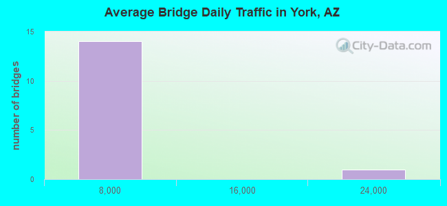
- 45,884Total average daily traffic
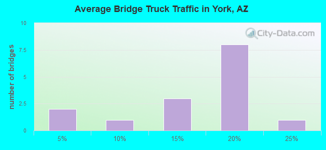
- 6,676Total average daily truck traffic
- 46,398Total future (year 2035) average daily traffic
- National Bridge Inventory (NBI) Registered Bridges for York
- No street view available for this location
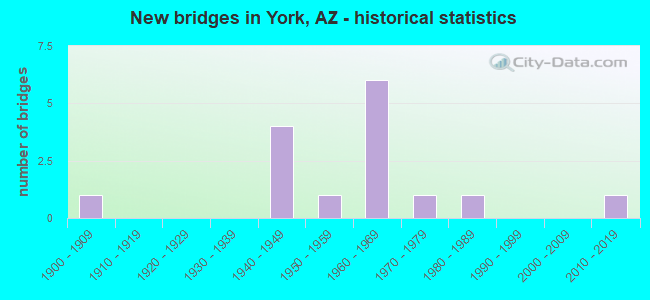
- New bridges - historical statistics
- 11900-1909
- 41940-1949
- 11950-1959
- 61960-1969
- 11970-1979
- 11980-1989
- 12010-2019
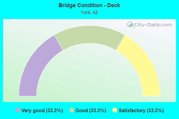
- Bridge Condition - Deck
- 33.3%Very good
- 33.3%Good
- 33.3%Satisfactory
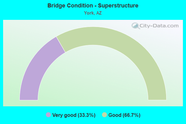
- Bridge Condition - Superstructure
- 33.3%Very good
- 66.7%Good
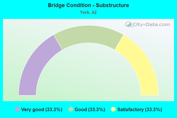
- Bridge Condition - Substructure
- 33.3%Very good
- 33.3%Good
- 33.3%Satisfactory
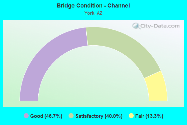
- Bridge Condition - Channel
- 46.7%Good
- 40.0%Satisfactory
- 13.3%Fair
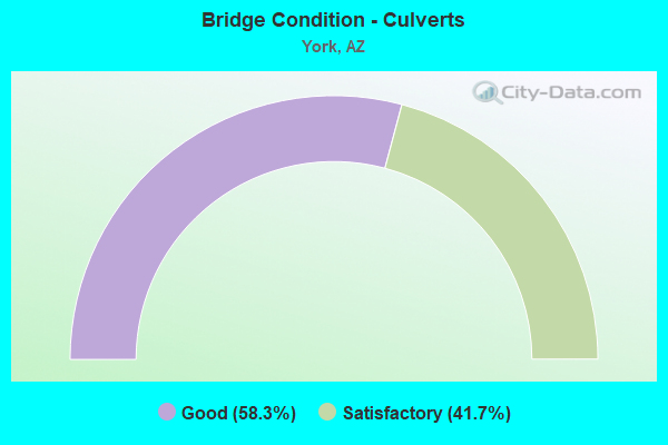
- Bridge Condition - Culverts
- 58.3%Good
- 41.7%Satisfactory
Find on map >> Show street view
Structure Number: 983, Location: 6.7 mi S Jct US 191 (Lat: 32.867869, Lng: -109.188592), Route carried "on" structure: State highway 75, Year Built: 1967, Status: Open, Structure Length: 6.96m (22.83ft), Average Daily Traffic: 1,789 (year 2019), Truck Traffic: 15%, Average Future Daily Traffic: 1,799 (year 2039), Design Load: HS 20, Features Intersected: Apache Creek
Minimum Vertical Clearance: 30+ m (98+ ft), Kilometerpoint: 630.477, Lanes on structure: 2, Owner: State Highway Agency, Approaching Roadway Width: 10.4m (34.1ft), Skew: 2 degrees, Material/Design: Concrete continuous, Design/Construction: Slab, Number Of Spans In Main Unit: 6, Length of Maximum Span: 12.2m (40.0ft), Curb-To-Curb Width: 10.4m (34.1ft), Out-to-Out Width: 11.2m (36.7ft)
Condition: Deck: Good, Superstructure: Good, Substructure: Good, Channel: Satisfactory, Operating Rating: 52.6 metric tons, Method Used To Determine Operating Rating: Load Factor (LF), Inventory Rating: 30.8 metric tons, Method Used To Determine Inventory Rating: Load Factor (LF), Structural Evaluation: Better than present minimum criteria, Deck Geometry: Equal to present minimum criteria, Waterway Adequacy: Equal to present desirable criteria, Approach Roadway Alignment: Equal to present desirable criteria, Designated Inspection Frequency: Every 24 months, Inspection Date: August 2021, Deck Structure Type: Concrete Cast-file-Place, Wearing Surface/Protective System: Wearing Surface: Bituminous
Find on map >> Show street view
Structure Number: 1884, Location: 0.4 mi N Jct SR 75 (Lat: 32.953822, Lng: -109.229228), Route carried "on" structure: US 191, Year Built: 1982, Status: Open, Structure Length: 12.62m (41.40ft), Average Daily Traffic: 2,625 (year 2019), Truck Traffic: 14%, Average Future Daily Traffic: 2,635 (year 2041), Design Load: HS 20, Features Intersected: Cold Creek
Minimum Vertical Clearance: 30+ m (98+ ft), Kilometerpoint: 249.287, Lanes on structure: 2, Owner: State Highway Agency, Approaching Roadway Width: 11.6m (38.1ft), Material/Design: Prestressed concrete continuous, Design/Construction: Stringer/Multi-beam, Number Of Spans In Main Unit: 5, Length of Maximum Span: 25.0m (82.0ft), Curb-To-Curb Width: 12.8m (42.0ft), Out-to-Out Width: 13.8m (45.3ft)
Condition: Deck: Satisfactory, Superstructure: Good, Substructure: Satisfactory, Channel: Good, Operating Rating: 89.8 metric tons, Method Used To Determine Operating Rating: Load Factor (LF), Inventory Rating: 49.9 metric tons, Method Used To Determine Inventory Rating: Load Factor (LF), Structural Evaluation: Equal to present minimum criteria, Deck Geometry: Equal to present desirable criteria, Waterway Adequacy: Equal to present desirable criteria, Approach Roadway Alignment: Equal to present minimum criteria, Designated Inspection Frequency: Every 24 months, Inspection Date: August 2021, Deck Structure Type: Concrete Cast-file-Place, Wearing Surface/Protective System: Wearing Surface: Monolithic Concrete
Find on map >> Show street view
Structure Number: 436, Location: 7.7 mi South Jct US 191 (Lat: 32.852600, Lng: -109.182000), Route carried "on" structure: State highway 75, Year Built: 1967, Status: Open, Structure Length: 0.70m (2.30ft), Average Daily Traffic: 1,562 (year 2015), Truck Traffic: 17%, Average Future Daily Traffic: 1,572 (year 2035), Design Load: HS 20, Features Intersected: Wash
Minimum Vertical Clearance: 30+ m (98+ ft), Kilometerpoint: 629.030, Lanes on structure: 2, Owner: State Highway Agency, Approaching Roadway Width: 10.4m (34.1ft), Material/Design: Concrete continuous, Design/Construction: Culvert, Number Of Spans In Main Unit: 2, Length of Maximum Span: 3.0m (9.8ft)
Condition: Channel: Satisfactory, Culverts: Good, Operating Rating: 89.8 metric tons, Method Used To Determine Operating Rating: Load Factor (LF), Inventory Rating: 89.8 metric tons, Method Used To Determine Inventory Rating: Load Factor (LF), Structural Evaluation: Better than present minimum criteria, Waterway Adequacy: Better than present minimum criteria, Approach Roadway Alignment: Equal to present desirable criteria, Designated Inspection Frequency: Every 48 months, Inspection Date: August 2021
Find on map >> Show street view
Structure Number: 4361, Location: 7.5 mi South Jct US 191 (Lat: 32.856300, Lng: -109.182700), Route carried "on" structure: State highway 75, Year Built: 1967, Status: Open, Structure Length: 1.68m (5.51ft), Average Daily Traffic: 984 (year 2019), Truck Traffic: 23%, Average Future Daily Traffic: 1,358 (year 2040), Design Load: HS 20, Features Intersected: Stove Wash
Minimum Vertical Clearance: 30+ m (98+ ft), Kilometerpoint: 629.330, Lanes on structure: 2, Owner: State Highway Agency, Approaching Roadway Width: 10.4m (34.1ft), Material/Design: Concrete continuous, Design/Construction: Culvert, Number Of Spans In Main Unit: 5, Length of Maximum Span: 3.0m (9.8ft)
Condition: Channel: Fair, Culverts: Good, Operating Rating: 89.8 metric tons, Method Used To Determine Operating Rating: Load Factor (LF), Inventory Rating: 89.8 metric tons, Method Used To Determine Inventory Rating: Load Factor (LF), Structural Evaluation: Better than present minimum criteria, Waterway Adequacy: Better than present minimum criteria, Approach Roadway Alignment: Equal to present desirable criteria, Designated Inspection Frequency: Every 48 months, Inspection Date: August 2021
Find on map >> Show street view
Structure Number: 4362, Location: 7.1 mi South Jct US 191 (Lat: 32.862200, Lng: -109.185600), Route carried "on" structure: State highway 75, Year Built: 1940, Year Reconstructed: 1967, Status: Open, Structure Length: 1.68m (5.51ft), Average Daily Traffic: 1,562 (year 2015), Truck Traffic: 17%, Average Future Daily Traffic: 1,572 (year 2035), Design Load: HS 20, Features Intersected: Kaywood Wash
Minimum Vertical Clearance: 30+ m (98+ ft), Kilometerpoint: 630.030, Lanes on structure: 2, Owner: State Highway Agency, Approaching Roadway Width: 10.7m (35.1ft), Material/Design: Concrete continuous, Design/Construction: Culvert, Number Of Spans In Main Unit: 5, Length of Maximum Span: 3.0m (9.8ft)
Condition: Channel: Satisfactory, Culverts: Satisfactory, Operating Rating: 89.8 metric tons, Method Used To Determine Operating Rating: Load Factor (LF), Inventory Rating: 89.8 metric tons, Method Used To Determine Inventory Rating: Load Factor (LF), Structural Evaluation: Equal to present minimum criteria, Waterway Adequacy: Equal to present minimum criteria, Approach Roadway Alignment: Equal to present desirable criteria, Designated Inspection Frequency: Every 48 months, Inspection Date: August 2021
Find on map >> Show street view
Structure Number: 4363, Location: 5.0 mi South Jct US 191 (Lat: 32.891300, Lng: -109.197600), Route carried "on" structure: State highway 75, Year Built: 1967, Status: Open, Structure Length: 1.68m (5.51ft), Average Daily Traffic: 2,154 (year 2015), Truck Traffic: 15%, Average Future Daily Traffic: 2,164 (year 2035), Design Load: HS 20, Features Intersected: Rocky John Canyon
Minimum Vertical Clearance: 30+ m (98+ ft), Kilometerpoint: 633.360, Lanes on structure: 2, Owner: State Highway Agency, Approaching Roadway Width: 10.4m (34.1ft), Material/Design: Concrete continuous, Design/Construction: Culvert, Number Of Spans In Main Unit: 5, Length of Maximum Span: 3.0m (9.8ft)
Condition: Channel: Good, Culverts: Satisfactory, Operating Rating: 89.8 metric tons, Method Used To Determine Operating Rating: Load Factor (LF), Inventory Rating: 89.8 metric tons, Method Used To Determine Inventory Rating: Load Factor (LF), Structural Evaluation: Equal to present minimum criteria, Waterway Adequacy: Equal to present desirable criteria, Approach Roadway Alignment: Equal to present desirable criteria, Designated Inspection Frequency: Every 48 months, Inspection Date: August 2021
Find on map >> Show street view
Structure Number: 4364, Location: 4.0 mi South Jct US 191 (Lat: 32.904700, Lng: -109.197000), Route carried "on" structure: State highway 75, Year Built: 1940, Year Reconstructed: 1967, Status: Open, Structure Length: 0.64m (2.10ft), Average Daily Traffic: 2,154 (year 2015), Truck Traffic: 15%, Average Future Daily Traffic: 2,164 (year 2035), Design Load: HS 20, Features Intersected: Wash
Minimum Vertical Clearance: 30+ m (98+ ft), Kilometerpoint: 634.980, Lanes on structure: 2, Owner: State Highway Agency, Approaching Roadway Width: 10.4m (34.1ft), Material/Design: Concrete continuous, Design/Construction: Culvert, Number Of Spans In Main Unit: 2, Length of Maximum Span: 3.0m (9.8ft)
Condition: Channel: Good, Culverts: Good, Operating Rating: 89.8 metric tons, Method Used To Determine Operating Rating: Load Factor (LF), Inventory Rating: 89.8 metric tons, Method Used To Determine Inventory Rating: Load Factor (LF), Structural Evaluation: Better than present minimum criteria, Waterway Adequacy: Equal to present desirable criteria, Approach Roadway Alignment: Equal to present desirable criteria, Designated Inspection Frequency: Every 48 months, Inspection Date: August 2021
Find on map >> Show street view
Structure Number: 4365, Location: 3.4 mi South Jct US 191 (Lat: 32.913000, Lng: -109.197300), Route carried "on" structure: State highway 75, Year Built: 1940, Year Reconstructed: 1967, Status: Open, Structure Length: 2.26m (7.41ft), Average Daily Traffic: 2,154 (year 2015), Truck Traffic: 15%, Average Future Daily Traffic: 2,164 (year 2035), Design Load: HS 20, Features Intersected: Greaser Wash
Minimum Vertical Clearance: 30+ m (98+ ft), Kilometerpoint: 635.920, Lanes on structure: 2, Owner: State Highway Agency, Approaching Roadway Width: 10.4m (34.1ft), Skew: 3 degrees, Material/Design: Concrete continuous, Design/Construction: Culvert, Number Of Spans In Main Unit: 6, Length of Maximum Span: 3.0m (9.8ft)
Condition: Channel: Satisfactory, Culverts: Satisfactory, Operating Rating: 89.8 metric tons, Method Used To Determine Operating Rating: Load Factor (LF), Inventory Rating: 89.8 metric tons, Method Used To Determine Inventory Rating: Load Factor (LF), Structural Evaluation: Equal to present minimum criteria, Waterway Adequacy: Equal to present desirable criteria, Approach Roadway Alignment: Equal to present desirable criteria, Designated Inspection Frequency: Every 48 months, Inspection Date: August 2021
Find on map >> Show street view
Structure Number: 4366, Location: 0.9 mi South Jct US 191 (Lat: 32.939700, Lng: -109.220400), Route carried "on" structure: State highway 75, Year Built: 1967, Status: Open, Structure Length: 1.95m (6.40ft), Average Daily Traffic: 2,154 (year 2015), Truck Traffic: 15%, Average Future Daily Traffic: 2,164 (year 2035), Design Load: HS 20, Features Intersected: Wash
Minimum Vertical Clearance: 30+ m (98+ ft), Kilometerpoint: 639.940, Lanes on structure: 2, Owner: State Highway Agency, Approaching Roadway Width: 10.4m (34.1ft), Material/Design: Concrete continuous, Design/Construction: Culvert, Number Of Spans In Main Unit: 6, Length of Maximum Span: 3.0m (9.8ft)
Condition: Channel: Satisfactory, Culverts: Good, Operating Rating: 89.8 metric tons, Method Used To Determine Operating Rating: Load Factor (LF), Inventory Rating: 89.8 metric tons, Method Used To Determine Inventory Rating: Load Factor (LF), Structural Evaluation: Better than present minimum criteria, Waterway Adequacy: Equal to present desirable criteria, Approach Roadway Alignment: Equal to present desirable criteria, Designated Inspection Frequency: Every 48 months, Inspection Date: August 2021
Find on map >> Show street view
Structure Number: 6524, Location: 1.0 mi S Jct SR 80 (Lat: 31.336500, Lng: -109.559900), Route carried "on" structure: Business US 191, Year Built: 1965, Status: Open, Structure Length: 0.98m (3.22ft), Average Daily Traffic: 2,823 (year 2017), Truck Traffic: 10%, Average Future Daily Traffic: 2,833 (year 2037), Design Load: HS 20, Features Intersected: Wash
Minimum Vertical Clearance: 30+ m (98+ ft), Kilometerpoint: 0.230, Lanes on structure: 5, Owner: State Highway Agency, Approaching Roadway Width: 20.7m (67.9ft), Material/Design: Concrete continuous, Design/Construction: Culvert, Number Of Spans In Main Unit: 3, Length of Maximum Span: 3.0m (9.8ft), Curb or Sidewalk Widths: Left: 1.2m (3.9ft), Right: 1.2m (3.9ft), Curb-To-Curb Width: 20.8m (68.2ft), Out-to-Out Width: 27.5m (90.2ft)
Condition: Channel: Good, Culverts: Good, Operating Rating: 53.5 metric tons, Method Used To Determine Operating Rating: Load Factor (LF), Inventory Rating: 32.7 metric tons, Method Used To Determine Inventory Rating: Load Factor (LF), Structural Evaluation: Better than present minimum criteria, Deck Geometry: Somewhat better than minimum adequacy, Waterway Adequacy: Equal to present desirable criteria, Approach Roadway Alignment: Equal to present desirable criteria, Designated Inspection Frequency: Every 48 months, Inspection Date: June 2018, Deck Structure Type: Concrete Cast-file-Place, Wearing Surface/Protective System: Wearing Surface: Bituminous
Find on map >> Show street view
Structure Number: 6525, Location: 24.4 mi W Jct SR 77 (Lat: 34.460542, Lng: -110.486103), Route carried "on" structure: State highway 277, Year Built: 1951, Status: Open, Structure Length: 0.76m (2.49ft), Average Daily Traffic: 1,180 (year 2019), Truck Traffic: 9%, Average Future Daily Traffic: 1,190 (year 2039), Design Load: HS 20, Features Intersected: Pearce Wash
Minimum Vertical Clearance: 30+ m (98+ ft), Kilometerpoint: 502.196, Lanes on structure: 2, Owner: State Highway Agency, Approaching Roadway Width: 8.5m (27.9ft), Material/Design: Concrete continuous, Design/Construction: Culvert, Number Of Spans In Main Unit: 2, Length of Maximum Span: 3.7m (12.1ft)
Condition: Channel: Satisfactory, Culverts: Good, Operating Rating: 68.9 metric tons, Method Used To Determine Operating Rating: Load Factor (LF), Inventory Rating: 41.7 metric tons, Method Used To Determine Inventory Rating: Load Factor (LF), Structural Evaluation: Better than present minimum criteria, Waterway Adequacy: Better than present minimum criteria, Approach Roadway Alignment: Equal to present minimum criteria, Designated Inspection Frequency: Every 48 months, Inspection Date: October 2020
Find on map >> Show street view
Structure Number: 6615, Location: 29.4 mi N Jct SR 289 (Lat: 31.825000, Lng: -111.013889), Route carried "on" structure: Interstate 19, Year Built: 1976, Status: Open, Structure Length: 0.64m (2.10ft), Average Daily Traffic: 20,000 (year 2015), Truck Traffic: 15%, Average Future Daily Traffic: 20,010 (year 2038), Design Load: HS 20, Features Intersected: Wash
Minimum Vertical Clearance: 30+ m (98+ ft), Kilometerpoint: 59.143, Lanes on structure: 4, Owner: State Highway Agency, Approaching Roadway Width: 19.5m (64.0ft), Skew: 20 degrees, Material/Design: Concrete continuous, Design/Construction: Culvert, Number Of Spans In Main Unit: 2, Length of Maximum Span: 3.0m (9.8ft)
Condition: Channel: Good, Culverts: Good, Operating Rating: 89.8 metric tons, Method Used To Determine Operating Rating: Load Factor (LF), Inventory Rating: 89.8 metric tons, Method Used To Determine Inventory Rating: Load Factor (LF), Structural Evaluation: Better than present minimum criteria, Waterway Adequacy: Equal to present desirable criteria, Approach Roadway Alignment: Equal to present desirable criteria, Designated Inspection Frequency: Every 48 months, Inspection Date: April 2021
Find on map >> Show street view
Structure Number: 8147, Location: 1.0 mi S Jct SR 75 (Lat: 32.891489, Lng: -109.203039), Route carried "on" structure: County highway , Year Built: 1900, Status: Open, Structure Length: 1.65m (5.41ft), Average Daily Traffic: 42 (year 2018), Truck Traffic: 1%, Average Future Daily Traffic: 52 (year 2038), Design Load: H 15, Features Intersected: Rocky John Canyon, Facility Carried by Structure: Cosper Loop
Minimum Vertical Clearance: 30+ m (98+ ft), Kilometerpoint: 0.000, Lanes on structure: 2, Owner: County Highway Agency, Approaching Roadway Width: 7.0m (23.0ft), Material/Design: Concrete continuous, Design/Construction: Culvert, Number Of Spans In Main Unit: 5, Length of Maximum Span: 3.0m (9.8ft)
Condition: Channel: Fair, Culverts: Satisfactory, Operating Rating: 89.8 metric tons, Method Used To Determine Operating Rating: Load Factor (LF), Inventory Rating: 89.8 metric tons, Method Used To Determine Inventory Rating: Load Factor (LF), Structural Evaluation: Equal to present minimum criteria, Waterway Adequacy: Equal to present desirable criteria, Approach Roadway Alignment: Equal to present minimum criteria, Designated Inspection Frequency: Every 24 months, Inspection Date: August 2021
Find on map >> Show street view
Structure Number: 8148, Location: 0.3 mi S Jct SR 75 (Lat: 32.939311, Lng: -109.222150), Route carried "on" structure: County highway , Year Built: 1941, Status: Open, Structure Length: 1.98m (6.50ft), Average Daily Traffic: 45 (year 2018), Truck Traffic: 1%, Average Future Daily Traffic: 55 (year 2038), Design Load: HS 20, Features Intersected: Willow Creek, Facility Carried by Structure: Carrell Loop
Minimum Vertical Clearance: 30+ m (98+ ft), Kilometerpoint: 0.000, Lanes on structure: 2, Owner: County Highway Agency, Approaching Roadway Width: 7.3m (24.0ft), Material/Design: Concrete continuous, Design/Construction: Culvert, Number Of Spans In Main Unit: 6, Length of Maximum Span: 3.0m (9.8ft)
Condition: Channel: Good, Culverts: Satisfactory, Operating Rating: 44.5 metric tons, Method Used To Determine Operating Rating: Allowable Stress (AS), Inventory Rating: 32.7 metric tons, Method Used To Determine Inventory Rating: Allowable Stress (AS), Structural Evaluation: Equal to present minimum criteria, Waterway Adequacy: Equal to present desirable criteria, Approach Roadway Alignment: Equal to present desirable criteria, Designated Inspection Frequency: Every 48 months, Inspection Date: August 2019
Find on map >> Show street view
Structure Number: 20036, Location: 0.4 mi N Jct SR 75 (Lat: 32.953786, Lng: -109.229436), Route carried "on" structure: US 191, Year Built: 2013, Status: Open, Structure Length: 12.28m (40.29ft), Average Daily Traffic: 4,656 (year 2020), Truck Traffic: 13%, Average Future Daily Traffic: 4,666 (year 2040), Design Load: HL 93, Features Intersected: Cold Creek
Minimum Vertical Clearance: 30+ m (98+ ft), Kilometerpoint: 249.287, Lanes on structure: 2, Owner: State Highway Agency, Approaching Roadway Width: 11.6m (38.1ft), Material/Design: Prestressed concrete continuous, Design/Construction: Stringer/Multi-beam, Number Of Spans In Main Unit: 5, Length of Maximum Span: 24.4m (80.1ft), Curb-To-Curb Width: 12.8m (42.0ft), Out-to-Out Width: 13.7m (44.9ft)
Condition: Deck: Very good, Superstructure: Very good, Substructure: Very good, Channel: Good, Operating Rating: 72.6 metric tons, Method Used To Determine Operating Rating: Load Factor (LF), Inventory Rating: 44.5 metric tons, Method Used To Determine Inventory Rating: Load Factor (LF), Structural Evaluation: Equal to present desirable criteria, Deck Geometry: Equal to present desirable criteria, Waterway Adequacy: Equal to present desirable criteria, Approach Roadway Alignment: Equal to present desirable criteria, Designated Inspection Frequency: Every 24 months, Inspection Date: September 2021, Deck Structure Type: Concrete Cast-file-Place, Wearing Surface/Protective System: Wearing Surface: Monolithic Concrete