Bridge Statistics for York, New York (NY)
Condition, Traffic, Stress, Structural Evaluation, Project Costs
- National Bridge Inventory (NBI) Statistics
- 17Number of bridges
- 115ft / 34.9mTotal length
- $16,287,000Total costs
- 33,675Total average daily traffic
- 4,496Total average daily truck traffic
- National Bridge Inventory (NBI) Registered Bridges for York
- No street view available for this location
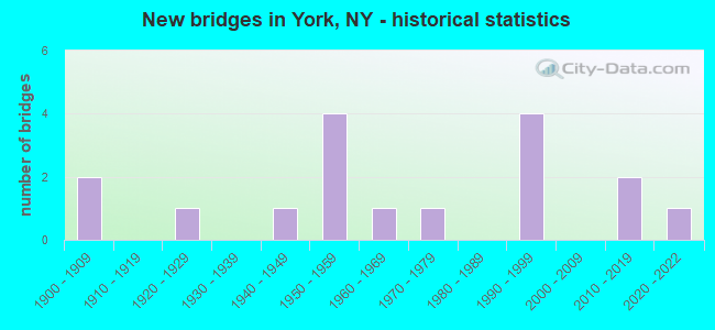
- New bridges - historical statistics
- 21900-1909
- 11920-1929
- 11940-1949
- 41950-1959
- 11960-1969
- 11970-1979
- 41990-1999
- 22010-2019
- 12020-2022
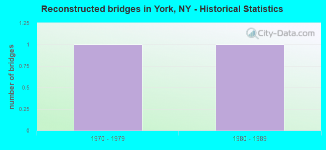
- Reconstructed bridges - Historical Statistics
- 11970-1979
- 11980-1989
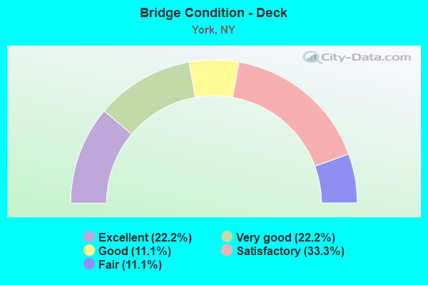
- Bridge Condition - Deck
- 22.2%Excellent
- 22.2%Very good
- 11.1%Good
- 33.3%Satisfactory
- 11.1%Fair
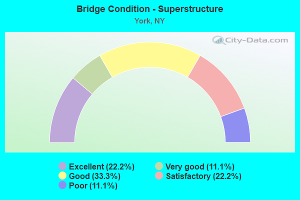
- Bridge Condition - Superstructure
- 22.2%Excellent
- 11.1%Very good
- 33.3%Good
- 22.2%Satisfactory
- 11.1%Poor
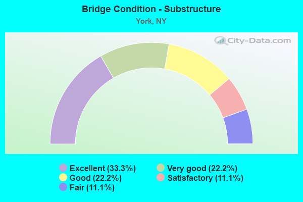
- Bridge Condition - Substructure
- 33.3%Excellent
- 22.2%Very good
- 22.2%Good
- 11.1%Satisfactory
- 11.1%Fair
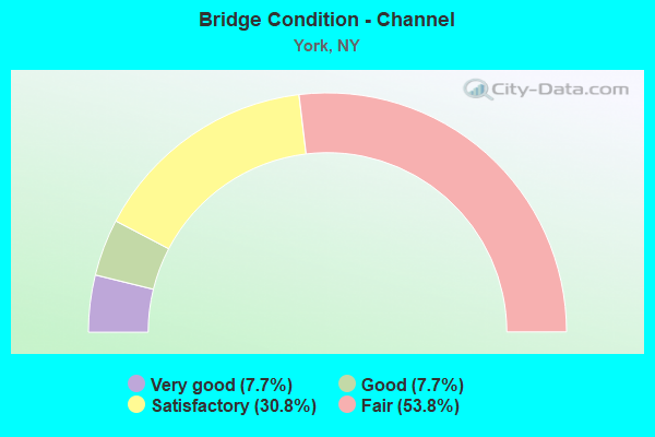
- Bridge Condition - Channel
- 7.7%Very good
- 7.7%Good
- 30.8%Satisfactory
- 53.8%Fair
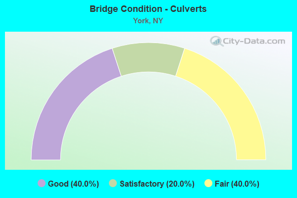
- Bridge Condition - Culverts
- 40.0%Good
- 20.0%Satisfactory
- 40.0%Fair
Find on map >> Show street view
Structure Number: 101571, Location: 0.2MI W JCT RTS 20 + 36 (Lat: 42.913733, Lng: -77.885447), Route carried "on" structure: US 20, Year Built: 2011, Status: Open, Structure Length: 1.19m (3.90ft), Average Daily Traffic: 2,212 (year 2018), Truck Traffic: 14%, Average Future Daily Traffic: 2,233 (year 2040), Design Load: HS 25 or greater, Features Intersected: Fowler Creek
Minimum Vertical Clearance: 30+ m (98+ ft), Kilometerpoint: 4.039, Lanes on structure: 2, Base Highway Network: Yes, Owner: State Highway Agency, Approaching Roadway Width: 10.8m (35.4ft), Skew: 2 degrees, Material/Design: Concrete, Design/Construction: Frame, Number Of Spans In Main Unit: 1, Length of Maximum Span: 11.3m (37.1ft), Curb-To-Curb Width: 10.8m (35.4ft), Out-to-Out Width: 11.8m (38.7ft)
Condition: Deck: Very good, Superstructure: Very good, Substructure: Excellent, Channel: Satisfactory, Operating Rating: 80.6 metric tons, Method Used To Determine Operating Rating: Field evaluation and documented engineering judgment, Inventory Rating: 40.8 metric tons, Method Used To Determine Inventory Rating: Field evaluation and documented engineering judgment, Structural Evaluation: Equal to present desirable criteria, Deck Geometry: Somewhat better than minimum adequacy, Waterway Adequacy: Equal to present minimum criteria, Approach Roadway Alignment: Equal to present desirable criteria, Length Of Structure Improvement: 1.18m (3.87ft), Designated Inspection Frequency: Every 24 months, Inspection Date: August 2021, Bridge Improvement Cost: $550,000, Roadway Improvement Cost: $322,000, Total Project Cost: $873,000 ( Estimate for 2021), Wearing Surface/Protective System: Wearing Surface: Bituminous
Find on map >> Show street view
Structure Number: 102372, Location: 0.2MI N JCT RTS 36 + 63 (Lat: 42.833744, Lng: -77.895886), Route carried "on" structure: State highway 36, Year Built: 1948, Year Reconstructed: 1977, Status: Open, Structure Length: 1.16m (3.81ft), Average Daily Traffic: 3,244 (year 2017), Truck Traffic: 9%, Average Future Daily Traffic: 3,264 (year 2040), Design Load: HS 20, Features Intersected: BIDWELLS CREEK
Minimum Vertical Clearance: 30+ m (98+ ft), Kilometerpoint: 40.273, Lanes on structure: 2, Base Highway Network: Yes, Owner: State Highway Agency, Approaching Roadway Width: 9.4m (30.8ft), Skew: 2 degrees, Material/Design: Steel, Design/Construction: Stringer/Multi-beam, Number Of Spans In Main Unit: 1, Length of Maximum Span: 10.4m (34.1ft), Curb-To-Curb Width: 9.7m (31.8ft), Out-to-Out Width: 10.3m (33.8ft)
Condition: Deck: Fair, Superstructure: Good, Substructure: Very good, Channel: Satisfactory, Operating Rating: 92.5 metric tons, Method Used To Determine Operating Rating: Load Factor (LF), Inventory Rating: 55.3 metric tons, Method Used To Determine Inventory Rating: Load Factor (LF), Structural Evaluation: Better than present minimum criteria, Deck Geometry: Meets minimum limits, Waterway Adequacy: Equal to present minimum criteria, Approach Roadway Alignment: Equal to present minimum criteria, Length Of Structure Improvement: 1.15m (3.77ft), Designated Inspection Frequency: Every 24 months, Inspection Date: November 2021, Bridge Improvement Cost: $668,000, Roadway Improvement Cost: $391,000, Total Project Cost: $1,059,000 ( Estimate for 2021), Deck Structure Type: Concrete Cast-file-Place, Wearing Surface/Protective System: Wearing Surface: Bituminous, Deck Protection: Epoxy Coated Reinforcing
Find on map >> Show street view
Structure Number: 10287, Location: JCT RTE 63 + GENESEE R (Lat: 42.804594, Lng: -77.827372), Route carried "on" structure: State highway 63, Year Built: 2020, Status: Open, Structure Length: 10.15m (33.30ft), Average Daily Traffic: 5,493 (year 2017), Truck Traffic: 27%, Average Future Daily Traffic: 5,545 (year 2040), Design Load: HL 93, Features Intersected: GENESEE RIVER
Minimum Vertical Clearance: 32.69m (107.25ft), Kilometerpoint: 34.787, Lanes on structure: 2, Base Highway Network: Yes, Owner: State Highway Agency, Approaching Roadway Width: 12.2m (40.0ft), Skew: 1 degrees, Material/Design: Steel, Design/Construction: Stringer/Multi-beam, Number Of Spans In Main Unit: 2, Length of Maximum Span: 52.7m (172.9ft), Curb-To-Curb Width: 12.2m (40.0ft), Out-to-Out Width: 13.2m (43.3ft)
Condition: Deck: Excellent, Superstructure: Excellent, Substructure: Excellent, Channel: Very good, Operating Rating: 62.6 metric tons, Method Used To Determine Operating Rating: Load Factor (LF), Inventory Rating: 37.2 metric tons, Method Used To Determine Inventory Rating: Load Factor (LF), Structural Evaluation: Superior to present desirable criteria, Deck Geometry: Somewhat better than minimum adequacy, Waterway Adequacy: Somewhat better than minimum adequacy, Approach Roadway Alignment: Equal to present desirable criteria, Length Of Structure Improvement: 10.14m (33.27ft), Designated Inspection Frequency: Every 24 months, Underwater Inspection Frequency: Every 60 months, Inspection Date: October 2020, Underwater Inspection Date: August 2020, Bridge Improvement Cost: $3,286,000, Roadway Improvement Cost: $1,924,000, Total Project Cost: $5,211,000 ( Estimate for 2021), Deck Structure Type: Concrete Cast-file-Place, Wearing Surface/Protective System: Wearing Surface: Monolithic Concrete, Deck Protection: Epoxy Coated Reinforcing
Find on map >> Show street view
Structure Number: 102871, Location: .2 MI W JCT SH 63 & SH 36 (Lat: 42.830650, Lng: -77.887239), Route carried "on" structure: State highway 63, Year Built: 1991, Status: Open, Structure Length: 4.91m (16.11ft), Average Daily Traffic: 5,493 (year 2017), Truck Traffic: 27%, Average Future Daily Traffic: 5,545 (year 2040), Design Load: HS 20, Features Intersected: GENESEE&WYOMING
Minimum Vertical Clearance: 30+ m (98+ ft), Kilometerpoint: 41.367, Lanes on structure: 2, Base Highway Network: Yes, Owner: State Highway Agency, Approaching Roadway Width: 13.4m (44.0ft), Skew: 1 degrees, Material/Design: Prestressed concrete, Design/Construction: Box Beam or Girders - Multiple, Number Of Spans In Main Unit: 3, Length of Maximum Span: 17.9m (58.7ft), Curb-To-Curb Width: 13.2m (43.3ft), Out-to-Out Width: 14.2m (46.6ft)
Condition: Deck: Very good, Superstructure: Good, Substructure: Very good, Operating Rating: 89.8 metric tons, Method Used To Determine Operating Rating: Load Factor (LF), Inventory Rating: 40.8 metric tons, Method Used To Determine Inventory Rating: Load Factor (LF), Structural Evaluation: Better than present minimum criteria, Deck Geometry: Somewhat better than minimum adequacy, Underclear: Equal to present minimum criteria, Approach Roadway Alignment: Equal to present desirable criteria, Length Of Structure Improvement: 4.90m (16.08ft), Designated Inspection Frequency: Every 24 months, Inspection Date: November 2020, Bridge Improvement Cost: $1,322,000, Roadway Improvement Cost: $774,000, Total Project Cost: $2,096,000 ( Estimate for 2021), Deck Structure Type: Concrete Cast-file-Place, Wearing Surface/Protective System: Wearing Surface: Bituminous, Membrane: Other, Deck Protection: Epoxy Coated Reinforcing
Find on map >> Show street view
Structure Number: 107923, Location: 0.1 M S RT20 (Lat: 42.912567, Lng: -77.880817), Route carried "on" structure: State highway 36, Year Built: 1958, Status: Open, Structure Length: 0.70m (2.30ft), Average Daily Traffic: 2,806 (year 2017), Truck Traffic: 13%, Average Future Daily Traffic: 2,823 (year 2040), Features Intersected: FOWLER CREEK
Minimum Vertical Clearance: 30+ m (98+ ft), Kilometerpoint: 49.235, Lanes on structure: 2, Base Highway Network: Yes, Owner: State Highway Agency, Approaching Roadway Width: 14.3m (46.9ft), Material/Design: Concrete, Design/Construction: Culvert, Number Of Spans In Main Unit: 1, Length of Maximum Span: 6.1m (20.0ft)
Condition: Channel: Fair, Culverts: Fair, Operating Rating: 91.7 metric tons, Method Used To Determine Operating Rating: Load and Resistance Factor Rating (LRFR) rating reported by rating factor(RF) method using HL-93 loadings, Inventory Rating: 70.6 metric tons, Method Used To Determine Inventory Rating: Load and Resistance Factor Rating (LRFR) rating reported by rating factor(RF) method using HL-93 loadings, Structural Evaluation: Somewhat better than minimum adequacy, Waterway Adequacy: Equal to present minimum criteria, Approach Roadway Alignment: Equal to present desirable criteria, Length Of Structure Improvement: 0.70m (2.30ft), Designated Inspection Frequency: Every 24 months, Inspection Date: July 2021, Bridge Improvement Cost: $306,000, Roadway Improvement Cost: $179,000, Total Project Cost: $485,000 ( Estimate for 2021)
Find on map >> Show street view
Structure Number: 108043, Location: 36 36 42021282_CREEK (Lat: 42.875611, Lng: -77.883244), Route carried "on" structure: State highway 36, Year Built: 1956, Status: Open, Structure Length: 0.67m (2.20ft), Average Daily Traffic: 2,806 (year 2017), Truck Traffic: 13%, Average Future Daily Traffic: 2,823 (year 2040), Design Load: HS 20, Features Intersected: Brown's Creek
Minimum Vertical Clearance: 32.69m (107.25ft), Kilometerpoint: 45.084, Lanes on structure: 2, Owner: State Highway Agency, Approaching Roadway Width: 14.3m (46.9ft), Material/Design: Concrete, Design/Construction: Culvert, Number Of Spans In Main Unit: 1, Length of Maximum Span: 6.1m (20.0ft)
Condition: Channel: Fair, Culverts: Fair, Inventory Rating: 77.1 metric tons, Method Used To Determine Inventory Rating: Load Factor (LF), Structural Evaluation: Somewhat better than minimum adequacy, Waterway Adequacy: Superior to present desirable criteria, Approach Roadway Alignment: Equal to present desirable criteria, Length Of Structure Improvement: 0.67m (2.20ft), Designated Inspection Frequency: Every 24 months, Inspection Date: April 2020, Bridge Improvement Cost: $172,000, Roadway Improvement Cost: $101,000, Total Project Cost: $273,000 ( Estimate for 2021), Wearing Surface/Protective System: Wearing Surface: Bituminous
Find on map >> Show street view
Structure Number: 221102, Location: 1.9 MI.E.OF YORK (Lat: 42.875475, Lng: -77.849444), Route carried "on" structure: Other road , Year Built: 1978, Status: Open, Structure Length: 0.76m (2.49ft), Average Daily Traffic: 786 (year 2017), Truck Traffic: 3%, Average Future Daily Traffic: 1,100 (year 2037), Features Intersected: BROWNS CREEK, Facility Carried by Structure: RIVER ROAD
Minimum Vertical Clearance: 30+ m (98+ ft), Kilometerpoint: 7.611, Lanes on structure: 2, Owner: Town or Township Highway Agency, Approaching Roadway Width: 6.1m (20.0ft), Material/Design: Aluminum, Iron, Design/Construction: Culvert, Number Of Spans In Main Unit: 1, Length of Maximum Span: 6.0m (19.7ft)
Condition: Channel: Fair, Culverts: Good, Operating Rating: 76.9 metric tons, Method Used To Determine Operating Rating: Field evaluation and documented engineering judgment, Inventory Rating: 32.7 metric tons, Method Used To Determine Inventory Rating: Field evaluation and documented engineering judgment, Structural Evaluation: Better than present minimum criteria, Waterway Adequacy: Better than present minimum criteria, Approach Roadway Alignment: Meets minimum limits, Length Of Structure Improvement: 0.76m (2.49ft), Designated Inspection Frequency: Every 24 months, Inspection Date: May 2021, Bridge Improvement Cost: $83,000, Roadway Improvement Cost: $49,000, Total Project Cost: $132,000 ( Estimate for 2021)
Find on map >> Show street view
Structure Number: 225803, Location: 2.7 MI NE OF YORK (Lat: 42.893439, Lng: -77.842697), Route carried "on" structure: Other road , Year Built: 1997, Status: Open, Structure Length: 0.85m (2.79ft), Average Daily Traffic: 326 (year 2020), Truck Traffic: 5%, Average Future Daily Traffic: 456 (year 2040), Design Load: HS 25 or greater, Features Intersected: FOWLER CREEK, Facility Carried by Structure: CASEY ROAD
Minimum Vertical Clearance: 30+ m (98+ ft), Kilometerpoint: 0.113, Lanes on structure: 2, Owner: Town or Township Highway Agency, Approaching Roadway Width: 7.3m (24.0ft), Skew: 1 degrees, Material/Design: Concrete, Design/Construction: Frame, Number Of Spans In Main Unit: 1, Length of Maximum Span: 7.9m (25.9ft), Curb-To-Curb Width: 8.6m (28.2ft), Out-to-Out Width: 9.2m (30.2ft)
Condition: Deck: Satisfactory, Superstructure: Satisfactory, Substructure: Good, Channel: Fair, Operating Rating: 78.2 metric tons, Method Used To Determine Operating Rating: Field evaluation and documented engineering judgment, Inventory Rating: 40.8 metric tons, Method Used To Determine Inventory Rating: Field evaluation and documented engineering judgment, Structural Evaluation: Equal to present minimum criteria, Deck Geometry: Equal to present minimum criteria, Waterway Adequacy: Better than present minimum criteria, Approach Roadway Alignment: Equal to present desirable criteria, Length Of Structure Improvement: 0.85m (2.79ft), Designated Inspection Frequency: Every 24 months, Inspection Date: September 2021, Bridge Improvement Cost: $310,000, Roadway Improvement Cost: $182,000, Total Project Cost: $492,000 ( Estimate for 2021), Wearing Surface/Protective System: Wearing Surface: Bituminous, Membrane: Preformed Fabric
Find on map >> Show street view
Structure Number: 331623, Location: 4 MI SOUTH OF CALEDONIA (Lat: 42.903897, Lng: -77.874806), Route carried "on" structure: Other road , Year Built: 2012, Status: Open, Structure Length: 1.43m (4.69ft), Average Daily Traffic: 87 (year 2017), Truck Traffic: 5%, Average Future Daily Traffic: 122 (year 2037), Design Load: HS 25 or greater, Features Intersected: FOWLER CREEK, Facility Carried by Structure: SIMPSON ROAD
Minimum Vertical Clearance: 30+ m (98+ ft), Kilometerpoint: 0.483, Lanes on structure: 2, Owner: County Highway Agency, Approaching Roadway Width: 7.3m (24.0ft), Material/Design: Wood or Timber, Design/Construction: Stringer/Multi-beam, Number Of Spans In Main Unit: 1, Length of Maximum Span: 14.0m (45.9ft), Curb-To-Curb Width: 7.9m (25.9ft), Out-to-Out Width: 8.5m (27.9ft)
Condition: Deck: Excellent, Superstructure: Excellent, Substructure: Excellent, Channel: Satisfactory, Operating Rating: 64.4 metric tons, Method Used To Determine Operating Rating: Allowable Stress (AS), Inventory Rating: 46.3 metric tons, Method Used To Determine Inventory Rating: Allowable Stress (AS), Structural Evaluation: Superior to present desirable criteria, Deck Geometry: Equal to present minimum criteria, Waterway Adequacy: Equal to present desirable criteria, Approach Roadway Alignment: Equal to present desirable criteria, Length Of Structure Improvement: 1.43m (4.69ft), Designated Inspection Frequency: Every 24 months, Inspection Date: June 2020, Bridge Improvement Cost: $713,000, Roadway Improvement Cost: $418,000, Total Project Cost: $1,131,000 ( Estimate for 2021), Deck Structure Type: Wood or Timber, Wearing Surface/Protective System: Wearing Surface: Bituminous, Membrane: Other
Find on map >> Show street view
Structure Number: 331624, Location: 3.3 MI NE OF YORK (Lat: 42.891825, Lng: -77.821428), Route carried "on" structure: County highway , Year Built: 1950, Status: Open, Structure Length: 9.27m (30.41ft), Average Daily Traffic: 1,294 (year 2018), Truck Traffic: 7%, Average Future Daily Traffic: 1,812 (year 2038), Design Load: HS 20, Features Intersected: GENESEE RIVER, Facility Carried by Structure: FOWLERVILLE ROAD
Minimum Vertical Clearance: 30+ m (98+ ft), Kilometerpoint: 4.843, Lanes on structure: 2, Owner: County Highway Agency, Approaching Roadway Width: 6.1m (20.0ft), Material/Design: Steel, Design/Construction: Stringer/Multi-beam, Number Of Spans In Main Unit: 3, Length of Maximum Span: 36.6m (120.1ft), Curb-To-Curb Width: 7.8m (25.6ft), Out-to-Out Width: 9.4m (30.8ft)
Condition: Deck: Satisfactory, Superstructure: Satisfactory, Substructure: Satisfactory, Channel: Good, Operating Rating: 65.3 metric tons, Method Used To Determine Operating Rating: Load Factor (LF), Inventory Rating: 38.1 metric tons, Method Used To Determine Inventory Rating: Load Factor (LF), Structural Evaluation: Equal to present minimum criteria, Deck Geometry: Meets minimum limits, Waterway Adequacy: Superior to present desirable criteria, Approach Roadway Alignment: Somewhat better than minimum adequacy, Length Of Structure Improvement: 9.26m (30.38ft), Designated Inspection Frequency: Every 24 months, Inspection Date: November 2020, Bridge Improvement Cost: $1,994,000, Roadway Improvement Cost: $1,168,000, Total Project Cost: $3,162,000 ( Estimate for 2021), Deck Structure Type: Concrete Cast-file-Place, Wearing Surface/Protective System: Wearing Surface: Bituminous
Find on map >> Show street view
Structure Number: 331625, Location: 1.8 MI N OF PIFFARD (Lat: 42.852989, Lng: -77.855367), Route carried "on" structure: Other road , Year Built: 1965, Status: Open, Structure Length: 0.67m (2.20ft), Average Daily Traffic: 791 (year 2018), Truck Traffic: 4%, Average Future Daily Traffic: 1,107 (year 2038), Features Intersected: SALT CREEK, Facility Carried by Structure: RIVER ROAD
Minimum Vertical Clearance: 30+ m (98+ ft), Kilometerpoint: 4.795, Lanes on structure: 2, Owner: County Highway Agency, Approaching Roadway Width: 6.4m (21.0ft), Material/Design: Steel, Design/Construction: Culvert, Number Of Spans In Main Unit: 1, Length of Maximum Span: 6.4m (21.0ft)
Condition: Channel: Fair, Culverts: Satisfactory, Operating Rating: 77.1 metric tons, Method Used To Determine Operating Rating: Field evaluation and documented engineering judgment, Inventory Rating: 32.7 metric tons, Method Used To Determine Inventory Rating: Field evaluation and documented engineering judgment, Structural Evaluation: Equal to present minimum criteria, Waterway Adequacy: Better than present minimum criteria, Approach Roadway Alignment: Meets minimum limits, Length Of Structure Improvement: 0.67m (2.20ft), Designated Inspection Frequency: Every 24 months, Inspection Date: August 2021, Bridge Improvement Cost: $77,000, Roadway Improvement Cost: $45,000, Total Project Cost: $122,000 ( Estimate for 2021)
Find on map >> Show street view
Structure Number: 331626, Location: 2.4 MI NE JCT RT63 & RT36 (Lat: 42.861247, Lng: -77.922231), Route carried "on" structure: County highway , Year Built: 1991, Status: Open, Structure Length: 0.79m (2.59ft), Average Daily Traffic: 215 (year 2020), Truck Traffic: 5%, Average Future Daily Traffic: 301 (year 2040), Design Load: HS 20, Features Intersected: BIDWELLS CREEK, Facility Carried by Structure: FEDERAL ROAD
Minimum Vertical Clearance: 30+ m (98+ ft), Kilometerpoint: 3.894, Lanes on structure: 2, Owner: County Highway Agency, Approaching Roadway Width: 7.9m (25.9ft), Skew: 3 degrees, Material/Design: Concrete, Design/Construction: Culvert, Number Of Spans In Main Unit: 1, Length of Maximum Span: 7.0m (23.0ft), Curb-To-Curb Width: 7.9m (25.9ft), Out-to-Out Width: 8.5m (27.9ft)
Condition: Channel: Fair, Culverts: Good, Operating Rating: 57.2 metric tons, Method Used To Determine Operating Rating: Load Factor (LF), Inventory Rating: 32.7 metric tons, Method Used To Determine Inventory Rating: Load Factor (LF), Structural Evaluation: Better than present minimum criteria, Deck Geometry: Somewhat better than minimum adequacy, Waterway Adequacy: Better than present minimum criteria, Approach Roadway Alignment: Equal to present desirable criteria, Length Of Structure Improvement: 0.79m (2.59ft), Designated Inspection Frequency: Every 24 months, Inspection Date: May 2021, Bridge Improvement Cost: $229,000, Roadway Improvement Cost: $134,000, Total Project Cost: $363,000 ( Estimate for 2021), Wearing Surface/Protective System: Wearing Surface: Bituminous
Find on map >> Show street view
Structure Number: 331627, Location: 2.8 MI NW OF RESTOF (Lat: 42.845697, Lng: -77.903783), Route carried "on" structure: Other road , Year Built: 1925, Year Reconstructed: 1993, Status: Posted for load, Structure Length: 1.13m (3.71ft), Average Daily Traffic: 140 (year 2017), Truck Traffic: 3%, Average Future Daily Traffic: 196 (year 2037), Features Intersected: BIDWELLS CREEK, Facility Carried by Structure: DOW ROAD
Minimum Vertical Clearance: 30+ m (98+ ft), Kilometerpoint: 0.965, Lanes on structure: 2, Owner: County Highway Agency, Approaching Roadway Width: 4.9m (16.1ft), Skew: 2 degrees, Material/Design: Steel, Design/Construction: Girder and Floorbeam System, Number Of Spans In Main Unit: 1, Length of Maximum Span: 10.3m (33.8ft), Curb-To-Curb Width: 6.1m (20.0ft), Out-to-Out Width: 6.6m (21.7ft)
Condition: Deck: Satisfactory, Superstructure: Poor, Substructure: Fair, Channel: Satisfactory, Operating Rating: 25.6 metric tons, Method Used To Determine Operating Rating: Load and Resistance Factor Rating (LRFR) rating reported by rating factor(RF) method using HL-93 loadings, Inventory Rating: 19.8 metric tons, Method Used To Determine Inventory Rating: Load and Resistance Factor Rating (LRFR) rating reported by rating factor(RF) method using HL-93 loadings, Structural Evaluation: Meets minimum limits, Deck Geometry: Meets minimum limits, Waterway Adequacy: Better than present minimum criteria, Approach Roadway Alignment: Somewhat better than minimum adequacy, Bridge Posting: Required (Relationship of Operating Rating to Maximum Legal Load: > 39.9% below), Length Of Structure Improvement: 1.12m (3.67ft), Designated Inspection Frequency: Every 12 months, Critical Feature Inspection Frequency: Every 12 months, Inspection Date: July 2021, Critical Feature Inspection Date: July 2021, Bridge Improvement Cost: $301,000, Roadway Improvement Cost: $176,000, Total Project Cost: $478,000 ( Estimate for 2021), Deck Structure Type: Wood or Timber, Wearing Surface/Protective System: Wearing Surface: Bituminous
Find on map >> Show street view
Structure Number: 331628, Location: .5 MI NORTH OF RETSOF (Lat: 42.838606, Lng: -77.880953), Route carried "on" structure: Other road , Year Built: 1999, Status: Open, Structure Length: 1.22m (4.00ft), Average Daily Traffic: 1,038 (year 2018), Truck Traffic: 2%, Average Future Daily Traffic: 1,453 (year 2038), Design Load: HS 20, Features Intersected: BIDWELLS CREEK, Facility Carried by Structure: RETSOF ROAD
Minimum Vertical Clearance: 30+ m (98+ ft), Kilometerpoint: 3.073, Lanes on structure: 2, Owner: County Highway Agency, Approaching Roadway Width: 7.3m (24.0ft), Skew: 1 degrees, Material/Design: Wood or Timber, Design/Construction: Slab, Number Of Spans In Main Unit: 1, Length of Maximum Span: 11.9m (39.0ft), Curb-To-Curb Width: 8.5m (27.9ft), Out-to-Out Width: 9.1m (29.9ft)
Condition: Deck: Good, Superstructure: Good, Substructure: Good, Channel: Fair, Operating Rating: 77.1 metric tons, Method Used To Determine Operating Rating: Allowable Stress (AS), Inventory Rating: 54.4 metric tons, Method Used To Determine Inventory Rating: Allowable Stress (AS), Structural Evaluation: Better than present minimum criteria, Deck Geometry: Somewhat better than minimum adequacy, Waterway Adequacy: Better than present minimum criteria, Approach Roadway Alignment: Equal to present desirable criteria, Length Of Structure Improvement: 1.21m (3.97ft), Designated Inspection Frequency: Every 24 months, Inspection Date: August 2021, Bridge Improvement Cost: $259,000, Roadway Improvement Cost: $152,000, Total Project Cost: $410,000 ( Estimate for 2021), Wearing Surface/Protective System: Wearing Surface: Bituminous, Membrane: Other
Find on map >> Show street view
Structure Number: 702872, Location: .2 MI W JCT SH 63 & SH 36 (Lat: 42.830869, Lng: -77.900981), Route carried "under" structure: Alternate State highway 63, Year Built: 1950, Structure Length: 0. m, Average Daily Traffic: 6,804 (year 1998), Features Intersected: RTE 63, Facility Carried by Structure: GEN. & WYOM. RR A
Minimum Vertical Clearance: 4.31m (14.14ft), Kilometerpoint: 42.639, Lanes under structure: 2, Material/Design: Steel, Design/Construction: Girder and Floorbeam System, Length of Maximum Span: 16.7m (54.8ft)
Find on map >> Show street view
Structure Number: 7211031, Location: 1.5 MILES NW OF RETSOF (Lat: 42.845706, Lng: -77.904106), Route carried "under" structure: Other road , Year Built: 1901, Structure Length: 0. m, Average Daily Traffic: 70 (year 2017), Truck Traffic: 3%, Features Intersected: DOW ROAD, Facility Carried by Structure: Abandoned
Minimum Vertical Clearance: 4.29m (14.07ft), Kilometerpoint: 0.660, Lanes under structure: 2, Material/Design: Steel, Design/Construction: Stringer/Multi-beam, Length of Maximum Span: 9.1m (29.9ft)
Find on map >> Show street view
Structure Number: 7211032, Location: 1.5 MILES NW OF RETSOF (Lat: 42.845706, Lng: -77.904039), Route carried "under" structure: Other road , Year Built: 1901, Structure Length: 0. m, Average Daily Traffic: 70 (year 2017), Truck Traffic: 3%, Features Intersected: DOW ROAD, Facility Carried by Structure: DEC Trial/Pathway
Minimum Vertical Clearance: 4.50m (14.76ft), Kilometerpoint: 0.885, Lanes under structure: 2, Material/Design: Steel, Design/Construction: Girder and Floorbeam System, Length of Maximum Span: 9.1m (29.9ft)