Bridge Statistics for York Springs, Pennsylvania (PA)
Condition, Traffic, Stress, Structural Evaluation, Project Costs
- National Bridge Inventory (NBI) Statistics
- 11Number of bridges
- 26ft / 8.2mTotal length
- $1,643,000Total costs
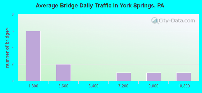
- 31,237Total average daily traffic
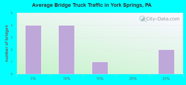
- 5,072Total average daily truck traffic
- National Bridge Inventory (NBI) Registered Bridges for York Springs
- No street view available for this location
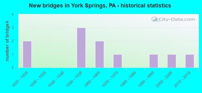
- New bridges - historical statistics
- 21920-1929
- 31950-1959
- 21960-1969
- 11970-1979
- 11990-1999
- 12000-2009
- 12010-2019
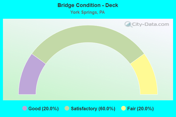
- Bridge Condition - Deck
- 20.0%Good
- 60.0%Satisfactory
- 20.0%Fair
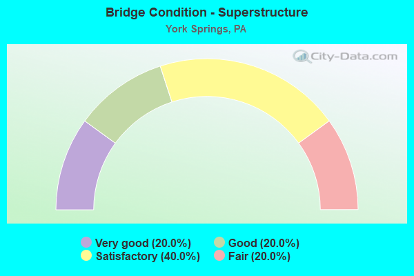
- Bridge Condition - Superstructure
- 20.0%Very good
- 20.0%Good
- 40.0%Satisfactory
- 20.0%Fair
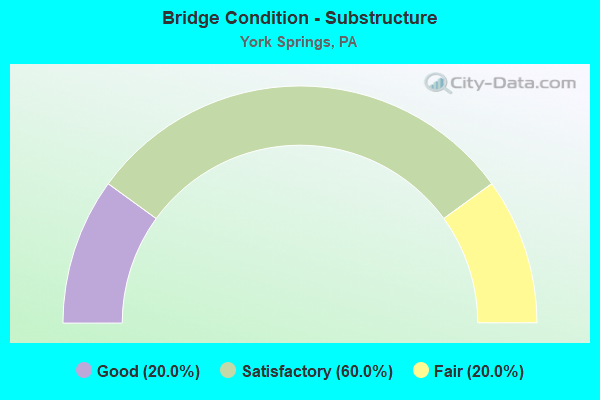
- Bridge Condition - Substructure
- 20.0%Good
- 60.0%Satisfactory
- 20.0%Fair
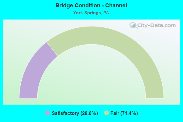
- Bridge Condition - Channel
- 28.6%Satisfactory
- 71.4%Fair
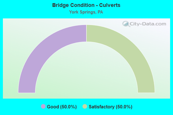
- Bridge Condition - Culverts
- 50.0%Good
- 50.0%Satisfactory
Find on map >> Show street view
Structure Number: 8, Location: .5 MI SE OF YORK SPRINGS (Lat: 39.995089, Lng: -77.094292), Route carried "on" structure: State highway 94, Year Built: 1927, Year Reconstructed: 2010, Status: Open, Structure Length: 2.50m (8.20ft), Average Daily Traffic: 6,609 (year 2020), Truck Traffic: 13%, Average Future Daily Traffic: 10,930 (year 2032), Design Load: H 15, Features Intersected: BERMUDIAN CREEK
Minimum Vertical Clearance: 30+ m (98+ ft), Kilometerpoint: 20.360, Lanes on structure: 2, Base Highway Network: Yes, Owner: State Highway Agency, Approaching Roadway Width: 9.1m (29.9ft), Material/Design: Prestressed concrete, Design/Construction: Box Beam or Girders - Single/Spread, Number Of Spans In Main Unit: 2, Length of Maximum Span: 12.2m (40.0ft), Curb or Sidewalk Widths: Left: 0.4m (1.3ft), Right: 0.4m (1.3ft), Curb-To-Curb Width: 11.6m (38.1ft), Out-to-Out Width: 12.3m (40.4ft)
Condition: Deck: Satisfactory, Superstructure: Very good, Substructure: Satisfactory, Channel: Satisfactory, Inventory Rating: 24.5 metric tons, Method Used To Determine Inventory Rating: Load Factor (LF), Structural Evaluation: Equal to present minimum criteria, Deck Geometry: Somewhat better than minimum adequacy, Waterway Adequacy: Superior to present desirable criteria, Approach Roadway Alignment: Better than present minimum criteria, Length Of Structure Improvement: 3.30m (10.83ft), Designated Inspection Frequency: Every 24 months, Inspection Date: June 2021, Bridge Improvement Cost: $112,000, Roadway Improvement Cost: $331,000, Total Project Cost: $1,517,000, Deck Structure Type: Concrete Cast-file-Place, Wearing Surface/Protective System: Wearing Surface: Monolithic Concrete, Deck Protection: Epoxy Coated Reinforcing
Find on map >> Show street view
Structure Number: 176, Location: 1 MI N OF LATIMORE (Lat: 40.059064, Lng: -77.114306), Route carried "on" structure: State highway , Year Built: 1950, Status: Open, Structure Length: 0.88m (2.89ft), Average Daily Traffic: 427 (year 2021), Truck Traffic: 5%, Average Future Daily Traffic: 1,086 (year 2032), Design Load: H 20, Features Intersected: LATIMORE CREEK, Facility Carried by Structure: SR 1005
Minimum Vertical Clearance: 30+ m (98+ ft), Kilometerpoint: 20.662, Lanes on structure: 2, Owner: State Highway Agency, Approaching Roadway Width: 5.5m (18.0ft), Skew: 1 degrees, Material/Design: Steel, Design/Construction: Stringer/Multi-beam, Number Of Spans In Main Unit: 1, Length of Maximum Span: 7.9m (25.9ft), Curb or Sidewalk Widths: Left: 0.2m (0.7ft), Right: 0.2m (0.7ft), Curb-To-Curb Width: 7.3m (24.0ft), Out-to-Out Width: 7.9m (25.9ft)
Condition: Deck: Fair, Superstructure: Fair, Substructure: Fair, Channel: Fair, Operating Rating: 59.0 metric tons, Method Used To Determine Operating Rating: Load Factor (LF), Inventory Rating: 35.4 metric tons, Method Used To Determine Inventory Rating: Load Factor (LF), Structural Evaluation: Somewhat better than minimum adequacy, Deck Geometry: Meets minimum limits, Waterway Adequacy: Better than present minimum criteria, Approach Roadway Alignment: Equal to present desirable criteria, Length Of Structure Improvement: 1.60m (5.25ft), Designated Inspection Frequency: Every 24 months, Inspection Date: June 2021, Bridge Improvement Cost: $9,000, Roadway Improvement Cost: $28,000, Total Project Cost: $126,000, Deck Structure Type: Closed Grating, Wearing Surface/Protective System: Wearing Surface: Bituminous
Find on map >> Show street view
Structure Number: 441, Location: 2 NE YORK SPRG/LATIMOR CR (Lat: 40.024244, Lng: -77.084222), Route carried "on" structure: City street , Year Built: 1920, Status: Open, Structure Length: 2.01m (6.59ft), Average Daily Traffic: 375 (year 2009), Truck Traffic: 7%, Average Future Daily Traffic: 525 (year 2030), Features Intersected: LATIMORE CREEK, Facility Carried by Structure: OLD RT. 15; T-602
Minimum Vertical Clearance: 30+ m (98+ ft), Kilometerpoint: 0.000, Lanes on structure: 2, Owner: County Highway Agency, Approaching Roadway Width: 6.1m (20.0ft), Material/Design: Concrete, Design/Construction: Tee Beam, Number Of Spans In Main Unit: 2, Length of Maximum Span: 9.8m (32.2ft), Curb or Sidewalk Widths: Left: 0.1m (0.3ft), Right: 0.1m (0.3ft), Curb-To-Curb Width: 7.1m (23.3ft), Out-to-Out Width: 8.0m (26.2ft)
Condition: Deck: Satisfactory, Superstructure: Satisfactory, Substructure: Satisfactory, Channel: Fair, Operating Rating: 54.4 metric tons, Method Used To Determine Operating Rating: Field evaluation and documented engineering judgment, Inventory Rating: 32.7 metric tons, Method Used To Determine Inventory Rating: Field evaluation and documented engineering judgment, Structural Evaluation: Equal to present minimum criteria, Deck Geometry: Meets minimum limits, Waterway Adequacy: Better than present minimum criteria, Approach Roadway Alignment: Equal to present desirable criteria, Length Of Structure Improvement: 2.00m (6.56ft), Designated Inspection Frequency: Every 24 months, Inspection Date: July 2021, Deck Structure Type: Concrete Cast-file-Place, Wearing Surface/Protective System: Wearing Surface: Bituminous
Find on map >> Show street view
Structure Number: 448, Location: 2.6 N YRKSPRG/LATIMORE CR (Lat: 40.048772, Lng: -77.100189), Route carried "on" structure: City street , Year Built: 1975, Status: Open, Structure Length: 0.73m (2.40ft), Average Daily Traffic: 50 (year 2005), Truck Traffic: 2%, Average Future Daily Traffic: 70 (year 2025), Features Intersected: LATIMORE CREEK, Facility Carried by Structure: BROUGH ROAD
Minimum Vertical Clearance: 30+ m (98+ ft), Kilometerpoint: 0.000, Lanes on structure: 2, Owner: Town or Township Highway Agency, Approaching Roadway Width: 3.7m (12.1ft), Material/Design: Concrete, Design/Construction: Slab, Number Of Spans In Main Unit: 1, Length of Maximum Span: 7.0m (23.0ft), Curb-To-Curb Width: 5.5m (18.0ft), Out-to-Out Width: 6.6m (21.7ft)
Condition: Deck: Good, Superstructure: Good, Substructure: Satisfactory, Channel: Fair, Operating Rating: 84.4 metric tons, Method Used To Determine Operating Rating: Field evaluation and documented engineering judgment, Inventory Rating: 49.9 metric tons, Method Used To Determine Inventory Rating: Field evaluation and documented engineering judgment, Structural Evaluation: Equal to present minimum criteria, Deck Geometry: Meets minimum limits, Waterway Adequacy: Better than present minimum criteria, Approach Roadway Alignment: Equal to present desirable criteria, Length Of Structure Improvement: 0.70m (2.30ft), Designated Inspection Frequency: Every 24 months, Inspection Date: July 2021, Wearing Surface/Protective System: Wearing Surface: Monolithic Concrete
Find on map >> Show street view
Structure Number: 41401, Location: 1.0 MI E. OF LATIMORE (Lat: 40.043236, Lng: -77.096475), Route carried "on" structure: City street , Year Built: 1999, Status: Open, Structure Length: 0.67m (2.20ft), Average Daily Traffic: 50 (year 2009), Truck Traffic: 2%, Average Future Daily Traffic: 70 (year 2030), Design Load: HS 20, Features Intersected: LATIMORE CREEK, Facility Carried by Structure: BUSHEY SCHOOL RD
Minimum Vertical Clearance: 30+ m (98+ ft), Kilometerpoint: 0.000, Lanes on structure: 2, Owner: Town or Township Highway Agency, Approaching Roadway Width: 5.2m (17.1ft), Material/Design: Concrete, Design/Construction: Culvert, Number Of Spans In Main Unit: 1, Length of Maximum Span: 6.7m (22.0ft), Curb-To-Curb Width: 7.5m (24.6ft), Out-to-Out Width: 8.4m (27.6ft)
Condition: Channel: Fair, Culverts: Satisfactory, Operating Rating: 72.6 metric tons, Method Used To Determine Operating Rating: Load Factor (LF), Inventory Rating: 43.5 metric tons, Method Used To Determine Inventory Rating: Load Factor (LF), Structural Evaluation: Equal to present minimum criteria, Deck Geometry: Equal to present minimum criteria, Waterway Adequacy: Somewhat better than minimum adequacy, Approach Roadway Alignment: Equal to present desirable criteria, Length Of Structure Improvement: 1.30m (4.27ft), Designated Inspection Frequency: Every 24 months, Inspection Date: July 2021, Deck Structure Type: Concrete Cast-file-Place, Wearing Surface/Protective System: Wearing Surface: Monolithic Concrete
Find on map >> Show street view
Structure Number: 42127, Location: 1.2 MILE S.E. LATIMORE (Lat: 40.032108, Lng: -77.104253), Route carried "on" structure: City street , Year Built: 2001, Status: Open, Structure Length: 0.73m (2.40ft), Average Daily Traffic: 50 (year 2009), Truck Traffic: 2%, Average Future Daily Traffic: 70 (year 2030), Design Load: HS 20, Features Intersected: TRIB. TO LATIMORE CREEK, Facility Carried by Structure: BONNERS HILL ROAD
Minimum Vertical Clearance: 30+ m (98+ ft), Kilometerpoint: 0.000, Lanes on structure: 2, Owner: Town or Township Highway Agency, Approaching Roadway Width: 6.4m (21.0ft), Material/Design: Wood or Timber, Design/Construction: Stringer/Multi-beam, Number Of Spans In Main Unit: 1, Length of Maximum Span: 7.0m (23.0ft), Curb-To-Curb Width: 7.0m (23.0ft), Out-to-Out Width: 7.9m (25.9ft)
Condition: Deck: Satisfactory, Superstructure: Satisfactory, Substructure: Good, Channel: Fair, Operating Rating: 49.9 metric tons, Method Used To Determine Operating Rating: Allowable Stress (AS), Inventory Rating: 37.2 metric tons, Method Used To Determine Inventory Rating: Allowable Stress (AS), Structural Evaluation: Equal to present minimum criteria, Deck Geometry: Somewhat better than minimum adequacy, Waterway Adequacy: Equal to present minimum criteria, Approach Roadway Alignment: Equal to present desirable criteria, Length Of Structure Improvement: 1.40m (4.59ft), Designated Inspection Frequency: Every 24 months, Inspection Date: July 2021, Deck Structure Type: Wood or Timber, Wearing Surface/Protective System: Wearing Surface: Wood or Timber
Find on map >> Show street view
Structure Number: 45993, Location: 2.5 Mi west of Latimore (Lat: 40.041617, Lng: -77.156856), Route carried "on" structure: State highway , Year Built: 2010, Status: Open, Structure Length: 0.70m (2.30ft), Average Daily Traffic: 498 (year 2021), Truck Traffic: 4%, Average Future Daily Traffic: 735 (year 2032), Design Load: HL 93, Features Intersected: Trib Latimore Creek, Facility Carried by Structure: 1004/ Goodyear Rd
Minimum Vertical Clearance: 30+ m (98+ ft), Kilometerpoint: 1.408, Lanes on structure: 2, Owner: State Highway Agency, Approaching Roadway Width: 7.6m (24.9ft), Skew: 4 degrees, Material/Design: Concrete, Design/Construction: Culvert, Number Of Spans In Main Unit: 1, Length of Maximum Span: 6.4m (21.0ft), Curb or Sidewalk Widths: Left: 0.6m (2.0ft), Right: 0.6m (2.0ft), Curb-To-Curb Width: 7.6m (24.9ft), Out-to-Out Width: 14.9m (48.9ft)
Condition: Channel: Satisfactory, Culverts: Good, Operating Rating: 68.9 metric tons, Method Used To Determine Operating Rating: Load and Resistance Factor (LRFR), Inventory Rating: 53.5 metric tons, Method Used To Determine Inventory Rating: Load and Resistance Factor (LRFR), Structural Evaluation: Better than present minimum criteria, Deck Geometry: Meets minimum limits, Waterway Adequacy: Equal to present minimum criteria, Approach Roadway Alignment: Equal to present desirable criteria, Designated Inspection Frequency: Every 48 months, Inspection Date: June 2019, Deck Structure Type: Concrete Cast-file-Place, Wearing Surface/Protective System: Wearing Surface: Monolithic Concrete, Membrane: Preformed Fabric, Deck Protection: Epoxy Coated Reinforcing
Find on map >> Show street view
Structure Number: 31, Location: E OF YORK SPRINGS (Lat: 40.000975, Lng: -77.105742), Route carried "under" structure: State highway 94, Year Built: 1957, Structure Length: 0. m, Average Daily Traffic: 2,624 (year 2020), Truck Traffic: 9%, Features Intersected: PA 94; SR 0094, Facility Carried by Structure: US 15; SR 0015
Minimum Vertical Clearance: 4.51m (14.80ft), Kilometerpoint: 21.269, Lanes on structure: 4, Lanes under structure: 4, Material/Design: Steel continuous, Design/Construction: Stringer/Multi-beam, Length of Maximum Span: 21.6m (70.9ft)
Find on map >> Show street view
Structure Number: 31, Location: E OF YORK SPRINGS (Lat: 40.000975, Lng: -77.105742), Route carried "under" structure: State highway 94, Year Built: 1957, Structure Length: 0. m, Average Daily Traffic: 2,624 (year 2020), Truck Traffic: 9%, Features Intersected: PA 94; SR 0094, Facility Carried by Structure: US 15; SR 0015
Minimum Vertical Clearance: 4.37m (14.34ft), Kilometerpoint: 21.269, Lanes on structure: 4, Lanes under structure: 4, Material/Design: Steel continuous, Design/Construction: Stringer/Multi-beam, Length of Maximum Span: 21.6m (70.9ft)
Find on map >> Show street view
Structure Number: 183, Location: 2 MI. N. OF HEIDLERSBURG (Lat: 39.979372, Lng: -77.125367), Route carried "under" structure: US 15, Year Built: 1968, Structure Length: 0. m, Average Daily Traffic: 9,197 (year 2021), Truck Traffic: 20%, Features Intersected: SR 0015 ; US 15, Facility Carried by Structure: SR 1009
Minimum Vertical Clearance: 4.82m (15.81ft), Kilometerpoint: 34.990, Lanes on structure: 2, Lanes under structure: 4, Material/Design: Prestressed concrete, Design/Construction: Box Beam or Girders - Single/Spread, Length of Maximum Span: 20.4m (66.9ft)
Find on map >> Show street view
Structure Number: 183, Location: 2 MI. N. OF HEIDLERSBURG (Lat: 39.979372, Lng: -77.125367), Route carried "under" structure: US 15, Year Built: 1968, Structure Length: 0. m, Average Daily Traffic: 8,733 (year 2021), Truck Traffic: 21%, Features Intersected: SR 0015 ; US 15, Facility Carried by Structure: SR 1009
Minimum Vertical Clearance: 4.60m (15.09ft), Kilometerpoint: 35.040, Lanes on structure: 2, Lanes under structure: 4, Material/Design: Prestressed concrete, Design/Construction: Box Beam or Girders - Single/Spread, Length of Maximum Span: 20.4m (66.9ft)