Please register to participate in our discussions with 2 million other members - it's free and quick! Some forums can only be seen by registered members. After you create your account, you'll be able to customize options and access all our 15,000 new posts/day with fewer ads.
If you haven't seen the Street View function for Google Maps, prepare to be blown away.
There are three views you can choose from - the standard animation road map, the above-satellite image (completely zoomable), and now the Street View.
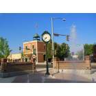
The Street View gives you a real life image of Boise as if you were driving the streets yourself. The image is 360 degree movable, meaning you can look in all four directions, zoom in and out, as well as up and down to some degree.
This will give you a complete virtual tour of Boise. Just about every single street in the Boise, Eagle, Meridian, and Kuna area are viewable, too!
The images were taken in the summer, and it looks like on an early Sunday morning, as there is little traffic out. You can also see how lush the city is, and by contrast how brown the surrounding foothills and mountains are. I can even see my car parked in front of my house - it's kind of eerie in that sense.
I love Google earth ... I used to virtually "fly" over Boise and Eagle online a lot prior to my move. That's how I first decided which areas I really wanted to explore and which I would prefer to avoid. It's great to see where the parks are ... where the industrial/congested areas are versus acreage and open space, etc.
It's great fun. I've even been known to fly over Paris and Manhattan when I'm feeling the need to see the city.
My understanding of Google is the pictures can be anywhere from 2 to 3 years old. It's hard to keep them current as they are doing the whole world so to speak. I work with this cool program that coincides with Google Earth and local listings so it gives you an aerial view of where a listing might be located. It's great for people who are new to the area as it offers a birds eye view, you just type in the address and you zoom right to it. Pretty amazing.
ooh just looked up my house, these pictures look very current, they must have just re-taken them, looks like last summer.
This looks like a newer/better format than what they originally had. I've been able to pull Boise on Google Earth for almost two years now, but the pictures weren't as good as this.
You know, I don't think they've loaded everything yet. I just typed in a house a client was looking at and they don't have the 360 view available yet which is the street view. They have the satellite view though, but that's it.
Please register to post and access all features of our very popular forum. It is free and quick. Over $68,000 in prizes has already been given out to active posters on our forum. Additional giveaways are planned.
Detailed information about all U.S. cities, counties, and zip codes on our site: City-data.com.

 Please register to participate in our discussions with 2 million other members - it's free and quick! Some forums can only be seen by registered members. After you create your account, you'll be able to customize options and access all our 15,000 new posts/day with fewer ads.