Professor From California State University Proposed The US to Redraw State Boundaries to 38 States in 1973 (tax, living)
Please register to participate in our discussions with 2 million other members - it's free and quick! Some forums can only be seen by registered members. After you create your account, you'll be able to customize options and access all our 15,000 new posts/day with fewer ads.
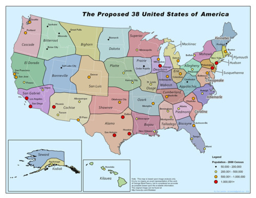
In 1973, the California State University geography professor suggested that the U.S. should redraw its antiquated state boundaries and narrow the overall number of states to a mere thirty-eight.
Pearcy’s proposed state lines were drawn in less-populated areas, isolating large cities and reducing their number within each state. He argued that if there were fewer cities vying for a state’s tax dollars, more money would be available for projects that would benefit all citizens.
Because the current states were being chopped up beyond recognition, part of his plan included renaming the new states by referencing natural geologic features or the region’s cultural history.
While he did have a rather staunch support network—economists, geographers, and even a few politicians argued that Pearcy’s plan might be crazy enough to work—the proposal was defeated in Washington, D.C. Imagine all the work that would have to be done to enact Pearcy’s plan: re-surveying the land, setting up new voter districts, new taxation infrastructure—basically starting the whole country over. It’s easy to see why the government balked.
The map above was published in 1973. Oddly, it doesn’t show any city locations to help illustrate Pearcy’s argument. At this point, I should tell you that I make maps for a living. So I did my best to replicate Pearcy’s map using population data from the 2000 census to show current high population cities and where they would fall within the new states. Here’s what I came up with:
Location: Austin, TX/Chicago, IL/Houston, TX/Washington, DC
10,138 posts, read 16,032,687 times
Reputation: 4047
New York (or whatever state had that city & metro) would become the most powerful state. California & Texas would both get screwed with this. So nope, just even trying to vision that wouldn't work out nicely for collective thoughts.
The split on Alaska seems kind of stupid no? I do like what happens to Illinois, I definitely think Chicago, Madison, Milwaukee and those portions of Wisc. and Mi. would benefit a lot from each other if they were in the same state.
Very interesting. I think as far as hypothetical, it makes sense. However, in practice it doesn't seem plausible. Interesting enough, I live in Charlotte. I see that the Carolinas's would be split With Raleigh getting Eastern NC and Charlotte getting Western NC (except for extreme western NC->which is tied to it TN brothers) and SC. Many of us in Charlotte seem to agree that Charlotte shares much with SC than it does with Greenville,NC.
New York (or whatever state had that city & metro) would become the most powerful state. California & Texas would both get screwed with this. So nope, just even trying to vision that wouldn't work out nicely for collective thoughts.
Concerning the Northeastern states, it looks to be split among current CSA definitions. It makes sense to me and so I agree.
edit:
I also don't like what happens to the Ohio metros. It looks like Cincy and Cbus stay in the same state, Cleveland goes with Pittsburgh? Am I seeing that right?
A lot of the states do resemble MTA. However, even MTAs number 51, I think that includes Puerto Rico. In the map being discussed, for example, the Charlotte-Raleigh-Greenville-Greensboro MTA is split in half pretty much. It also seems Richmond is in Chesapeake, while Virginnia Beach-Norfolk is in the Albermarle with Raleigh.
Makes sense. The states were set up at a time when communication and transportation were poor, so smaller states were favored. It's not a coincidence that the states get bigger as you go west - both communication and transportation improved dramatically over the years. Today, we have fifty governments which often perform duplicate functions which could be handled much more efficiently by the federal government, or at least by a much smaller number of districts (states) than 50. That's why the current Tea Party push for states' rights kind of baffles me.
States are irrelevant today imo. Maybe it's just my perspective as someone from South Jersey who works and plays in Philadelphia during the summers, and who during the rest of the year attends college in Maryland but always goes to DC.
Location: Austin, TX/Chicago, IL/Houston, TX/Washington, DC
10,138 posts, read 16,032,687 times
Reputation: 4047
Quote:
Originally Posted by soug
States are irrelevant today imo.
I agree, states are becoming more and more irrelevant today. Most people use their states as a show for pride or their politics to break through and hit the media these days.
In my opinion, its about the cities (and their metro's) more so these days and definitely will be the case in the long term future as the world heads into that direction. I read an article a while ago on this that made quite a good amount of sense on how cities in general are perceived as opposed to definitely states and maybe even countries (heading in that direction).
Excerpt:
Quote:
The 21st century will not be dominated by America or China, Brazil or India, but by the city. In an age that appears increasingly unmanageable, cities rather than states are becoming the islands of governance on which the future world order will be built. This new world is not—and will not be—one global village, so much as a network of different ones.
Time, technology, and population growth have massively accelerated the advent of this new urbanized era. Already, more than half the world lives in cities, and the percentage is growing rapidly. But just 100 cities account for 30 percent of the world’s economy, and almost all its innovation. Many are world capitals that have evolved and adapted through centuries of dominance: London, New York, Paris. New York City’s economy alone is larger than 46 of sub-Saharan Africa’s economies combined. Hong Kong receives more tourists annually than all of India. These cities are the engines of globalization, and their enduring vibrancy lies in money, knowledge, and stability. They are today’s true Global Cities.
There's a lot of different type of dynamics in the world, and cities are rapidly becoming the epicenter to most of them at a critical point in the world's history. States are increasingly becoming more irrelevant as the days go by (in my opinion) and those clinging on to them do it for cultural and historical reasons. Everyone, welcome to the free enterprise world, globally connected and the weakest link are left behind.
I would love for the Texaplex to be its own state (DFW to Houston to San Antonio though Austin back to DFW). The rest of the state (minus the Rio Grande Valley) sucks. The far right political views of the rest of the state totally screw the major cities over. Im not saying the majors are liberal, but they are more moderate.
Please register to post and access all features of our very popular forum. It is free and quick. Over $68,000 in prizes has already been given out to active posters on our forum. Additional giveaways are planned.
Detailed information about all U.S. cities, counties, and zip codes on our site: City-data.com.


 Please register to participate in our discussions with 2 million other members - it's free and quick! Some forums can only be seen by registered members. After you create your account, you'll be able to customize options and access all our 15,000 new posts/day with fewer ads.