Please register to participate in our discussions with 2 million other members - it's free and quick! Some forums can only be seen by registered members. After you create your account, you'll be able to customize options and access all our 15,000 new posts/day with fewer ads.
There is a 100 acre proposed development that is literally going into my backyard. Right now, this area is largely an arroyo. There are about twenty of us affected. There is a meeting this week where the county is "inviting input." I am not familiar with this county and this state in general. I wonder if by "inviting input" they mean they have already given the go-ahead to the developer and they are just humoring us folks or do they really mean "inviting input."
After last night's rain, it is clear to me that we need this arroyo. Does anybody have experience tackling these issues? I would appreciate any input. I have contacted the Nature Conservancy for some ideas but thus far I haven't turned up much of value. The meeting is this Thursday.
Thanks in advance.
Is this development on High Range, off Roadrunner Parkway?
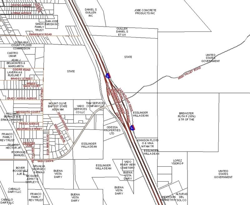
The area is by Lords Ranch near the Vado exit of I-10. The area was originally Bishops Cap Ranch I think. One side is BLM and the other is Fort Bliss. There is this sprinkling of privately owned land in middle and the 100 acres runs through it. The arroyo drains all of our run off to the Rio Grande.
The area is by Lords Ranch near the Vado exit of I-10. The area was originally Bishops Cap Ranch I think. One side is BLM and the other is Fort Bliss. There is this sprinkling of privately owned land in middle and the 100 acres runs through it. The arroyo drains all of our run off to the Rio Grande.
Tell me if it's close to here:
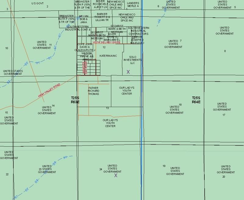
I labeled the larger parcels by owner. I can tell you if the land is public or privately owned. I also have some flood data.
Yes, the land is off High Valley Road. It runs to Santana Road. The development is slated for north and south of Santana Road.
I will check out that site. I know who the developer is but I don't know if it is public or private, etc.
Any flood data would be invaluable. That seems to be the most obvious and real concern regarding the development of this land. In looking at the map, on the left side of 1-10 there is a flood control property wedged in. That in fact, could be a part of this larger arroyo system coming down out of the desert. Is that possible?
Use my map to compare where your parcel is to what the above map is. That map is current, and was required by FEMA to federally insure properties. That hatch symbol of zone A is current. I included some stream data, which really constitutes probably part-year surface water, or ephemeral stream data:
Thanks so much Mike. It would appear that we are on an island between two flood plains. Makes me feel secure! While the Dona Ana County development requirement do not demand any hydrologic engineering analysis, it does make one think what is the outcome of destroying watershed in a place where water literally flows on every side of you to the lowest point. Interesting. Thanks again for these references.
We prevailed. The plan was denied. I am sure there will be a new plan to replace it. Ever vigilant.
Please register to post and access all features of our very popular forum. It is free and quick. Over $68,000 in prizes has already been given out to active posters on our forum. Additional giveaways are planned.
Detailed information about all U.S. cities, counties, and zip codes on our site: City-data.com.

 Please register to participate in our discussions with 2 million other members - it's free and quick! Some forums can only be seen by registered members. After you create your account, you'll be able to customize options and access all our 15,000 new posts/day with fewer ads.