Please register to participate in our discussions with 2 million other members - it's free and quick! Some forums can only be seen by registered members. After you create your account, you'll be able to customize options and access all our 15,000 new posts/day with fewer ads.
Only the Northern Orange line should be moved a couple centimeter to the right on the map.
Hmm......This National Geographic map, and this CIA world fact book map appear to include Hudson's Bay in the Arctic ocean. if that's the case, then Quebec counts.
Hmm......This National Geographic map, and this CIA world fact book map appear to include Hudson's Bay in the Arctic ocean. if that's the case, then Quebec counts.
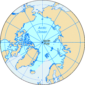
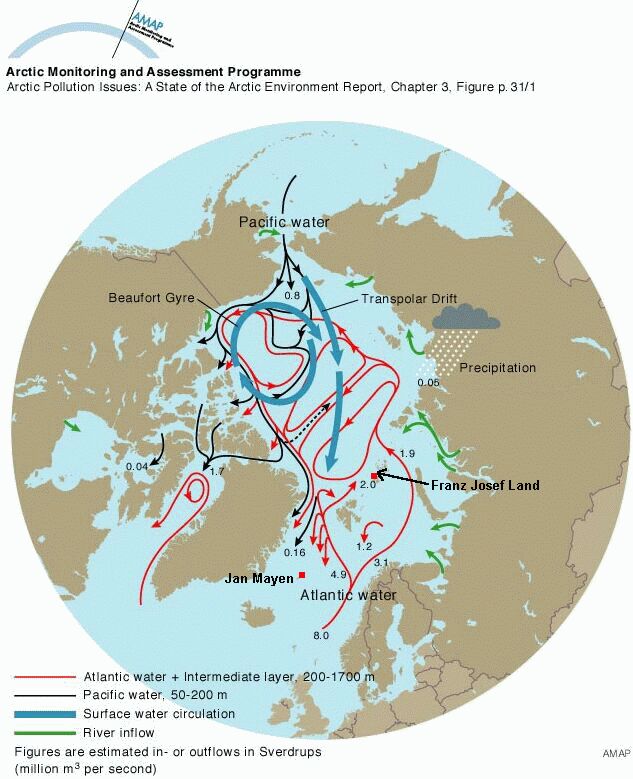
I can't see the last picture. The first three are just showing me the Arctic Circle, Ice pack limits, and the currents of Hudson's Bay.
Are you disagreeing, or agreeing with me?
Actually, the second picture I posted, the link says the following:
Area:
total: 14.056 million sq km
note: includes Baffin Bay, Barents Sea, Beaufort Sea, Chukchi Sea, East Siberian Sea, Greenland Sea, Hudson Bay, Hudson Strait, Kara Sea, Laptev Sea, Northwest Passage, and other tributary water bodies
I can't see the last picture. The first three are just showing me the Arctic Circle, Ice pack limits, and the currents of Hudson's Bay.
Are you disagreeing, or agreeing with me?
[/i]
Disagreeing
"Hudson Bay is part of the North Atlantic Ocean. Sometimes the Hudson Bay and Hudson Strait basins are considered part of the Arctic Ocean despite the fact that their waters flow predominantly to the Atlantic. Some sources describe Hudson Bay as a marginal sea of the Atlantic Ocean, or the Arctic Ocean."
Some even say the Baffin Bay is part of the Atlantic.
"Baffin Bay, located between Baffin Island and the southwest coast of Greenland, is a marginal sea of the North Atlantic Ocean. It is connected to the Atlantic via Davis Strait and the Labrador Sea. A narrower Nares Strait connects Baffin Bay with the Arctic Ocean."
"Baffin Bay is an arm of the Atlantic Ocean bounded by the Baffin Island in the west, Greenland in the east, and Ellesmere Island in the north. It connects to the Atlantic through the Davis Strait, and to the Arctic through several narrow channels of Nares Strait. It is a northwestern extension of the North Atlantic and Labrador Sea. It can also be viewed as a long strait separating Baffin Island and Greenland."
EDIT: Oh, nice disclaimer AFTER the fact, CIA!!!!!
Quote:
Your security and well being are our primary concerns. By visiting this website from outside of the U.S. and contacting us, you may be subject to monitoring by security or intelligence services, or other third parties that do not adhere to U.S. Internet privacy laws. While we employ numerous safeguards to help minimize this risk, we suggest that you not use your home or work computer to contact us. Use instead a computer where you are entirely unknown. Although our website is encrypted, it is still possible for others to see that you have visited CIA.gov. As an added precaution, we recommend you use current web browsers and clean the computer's search and/or browser histories after you visit the website.
LOL!
Last edited by Magnatomicflux; 06-21-2015 at 03:23 AM..
Please register to post and access all features of our very popular forum. It is free and quick. Over $68,000 in prizes has already been given out to active posters on our forum. Additional giveaways are planned.
Detailed information about all U.S. cities, counties, and zip codes on our site: City-data.com.

 Please register to participate in our discussions with 2 million other members - it's free and quick! Some forums can only be seen by registered members. After you create your account, you'll be able to customize options and access all our 15,000 new posts/day with fewer ads.