Central Westbury neighborhood in Westbury, New York (NY), 11590 detailed profile
Settings
X

Business Search - 14 Million verified businesses
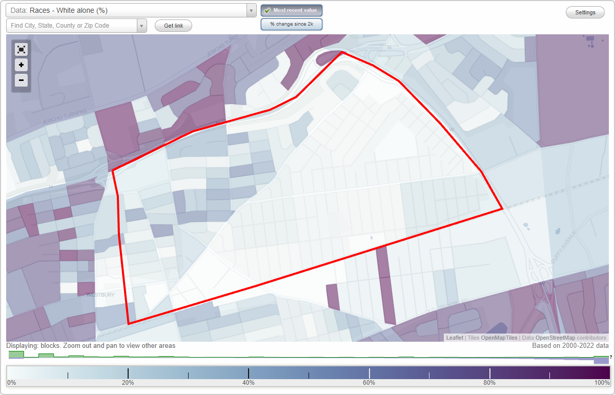
Area: 1.117 square miles
Population: 10,552
Population density:
| Central Westbury: | 9,447 people per square mile |
| Westbury: | 6,618 people per square mile |

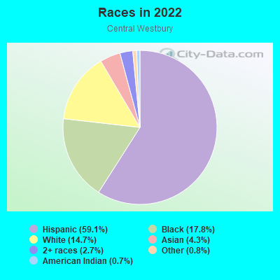
- 6,31659.1%Hispanic or Latino
- 1,90017.8%Black
- 1,57314.7%White
- 4634.3%Asian
- 2852.7%Two or more races
- 840.8%Some other race
- 740.7%American Indian
Median household income in 2022:
| Central Westbury: | $124,015 |
| Westbury: | $125,976 |
Distribution of median household income
![Distribution of median household income]()
- 160Less than $10,000
- 150$10,000 to $19,999
- 190$20,000 to $29,999
- 81$30,000 to $39,999
- 174$40,000 to $49,999
- 140$50,000 to $59,999
- 133$60,000 to $74,999
- 426$75,000 to $99,999
- 802$100,000 to $124,999
- 409$125,000 to $149,999
- 368$150,000 to $199,999
- 328$200,000 or more

Distribution of owner-occupied house/condo value
![Distribution of owner-occupied house/condo value]()
- 39Less than $50,000
- 102$50,000 to $99,999
- 347$100,000 to $149,999
- 119$150,000 to $199,999
- 119$200,000 to $249,999
- 102$250,000 to $299,999
- 548$300,000 to $399,999
- 288$400,000 to $499,999
- 1,043$500,000 to $749,999
- 78$750,000 to $999,999
- 55$1,000,000 or more

Distribution of rent paid by renters
![Distribution of rent paid by renters]()
- 14$700 to $799
- 169$1,000 to $1,249
- 253$1,250 to $1,499
- 263$1,500 to $1,999
- 1,793$2,000 or more

| Males: | 4,652 |
| Females: | 5,899 |
Males:
| This neighborhood: | 45.1 years |
| Whole city: | 43.9 years |
| This neighborhood: | 39.7 years |
| Whole city: | 43.1 years |
Average household size:
| Central Westbury: | 8.2 people |
| Westbury: | 32.0 people |
Percentage of family households:
| Central Westbury: | 51.5% |
| Westbury: | 48.2% |
| Here: | 45.3% |
| Westbury: | 56.2% |
Percentage of married-couple families with children (among all households):
| Central Westbury: | 11.4% |
| Westbury: | 24.7% |
Percentage of single-mother households (among all households):
| Central Westbury: | 8.8% |
| Westbury: | 3.8% |
Percentage of never married males 15 years old and over:
Percentage of never married females 15 years old and over:
| Central Westbury: | 21.8% |
| Westbury: | 17.3% |
Percentage of never married females 15 years old and over:
| Central Westbury: | 20.8% |
| village: | 16.9% |
Percentage of people that speak English not well or not at all:
| Central Westbury: | 17.1% |
| Westbury: | 10.2% |
Percentage of people born in this state:
Percentage of people born in another U.S. state:
Percentage of native residents but born outside the U.S.:
Percentage of foreign born residents:
| Here: | 47.0% |
| Westbury: | 60.3% |
Percentage of people born in another U.S. state:
| Central Westbury: | 3.5% |
| Westbury: | 4.4% |
Percentage of native residents but born outside the U.S.:
| Here: | 1.9% |
| village: | 2.1% |
Percentage of foreign born residents:
| Here: | 47.6% |
| Westbury: | 33.1% |
Owner-occupied
Renter-occupied

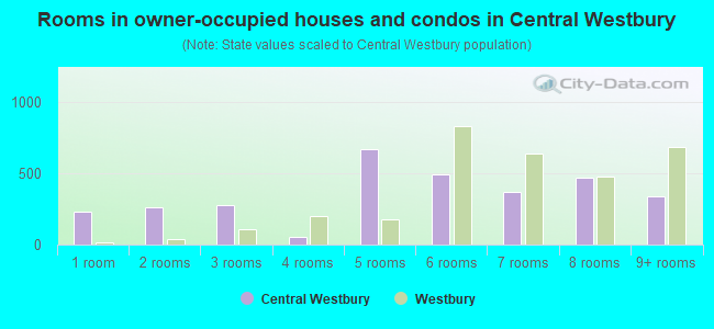
- Rooms in owner-occupied houses and condos in Central Westbury
- 2341 room
- 2622 rooms
- 2803 rooms
- 574 rooms
- 6655 rooms
- 4946 rooms
- 3697 rooms
- 4708 rooms
- 3419+ rooms
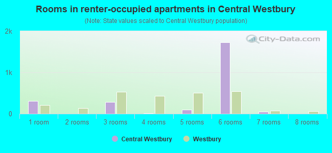
- Rooms in renter-occupied apartments in Central Westbury
- 3081 room
- 02 rooms
- 2803 rooms
- 134 rooms
- 985 rooms
- 1,7316 rooms
- 557 rooms
- 58 rooms
- 89+ rooms
Owner-occupied
Renter-occupied
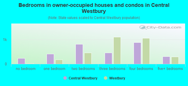
- Bedrooms in owner-occupied houses and condos in Central Westbury
- 234no bedroom
- 4111 bedroom
- 8052 bedrooms
- 4603 bedrooms
- 8754 bedrooms
- 3035+ bedrooms
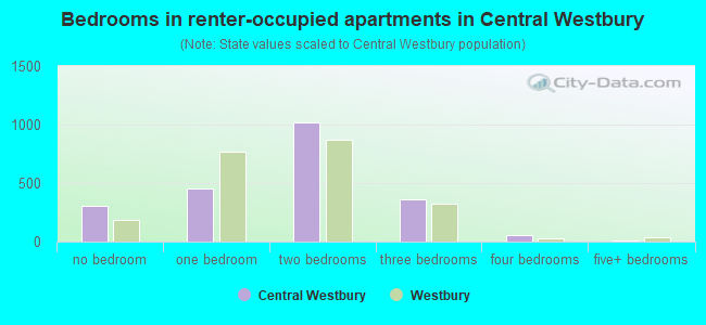
- Bedrooms in renter-occupied apartments in Central Westbury
- 308no bedroom
- 4581 bedroom
- 1,0202 bedrooms
- 3653 bedrooms
- 554 bedrooms
- 55+ bedrooms
Average number of cars or other vehicles available in houses/condos:
Average number of cars or other vehicles available in apartments:
| This neighborhood: | 1.9 |
| Westbury: | 2.1 |
Average number of cars or other vehicles available in apartments:
| Here: | |
| village: |
Percentage of units with a mortgage:
| Central Westbury: | 71.1% |
| Westbury: | 64.6% |
Average estimated value of detached houses in 2022 (61.9% of all units):
| Central Westbury: | $521,942 |
| New York: | $476,719 |
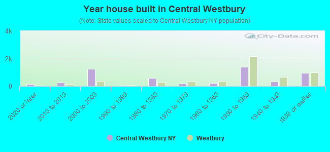
- Year house built in Central Westbury
- 1512020 or later
- 2542010 to 2019
- 1,2352000 to 2009
- 451990 to 1999
- 5801980 to 1989
- 1821970 to 1979
- 2351960 to 1969
- 1,3991950 to 1959
- 3151940 to 1949
- 9561939 or earlier
Travel time to work (commute)
![Travel time to work (commute)]()
- 52Less than 5 minutes
- 1085 to 9 minutes
- 62010 to 14 minutes
- 97115 to 19 minutes
- 75820 to 24 minutes
- 24125 to 29 minutes
- 58130 to 34 minutes
- 2335 to 39 minutes
- 16140 to 44 minutes
- 21345 to 59 minutes
- 31360 to 89 minutes
- 22990 or more minutes

Means of transportation to work
![Means of transportation to work]()
- 68.8%3,702Drove a car alone
- 13.9%749Carpooled
- 1.4%74Bus
- 4.3%231Subway or elevated rail
- 8.3%449Long-distance train or commuter rail
- 1.2%66Taxi
- 1.7%89Walked
- 2.8%149Other means
- 4.5%240Worked at home

Time leaving home to go to work
![Time leaving home to go to work]()
- 9312:00 a.m. to 4:59 a.m.
- 1825:00 a.m. to 5:29 a.m.
- 1935:30 a.m. to 5:59 a.m.
- 3936:00 a.m. to 6:29 a.m.
- 2686:30 a.m. to 6:59 a.m.
- 7877:00 a.m. to 7:29 a.m.
- 1677:30 a.m. to 7:59 a.m.
- 6478:00 a.m. to 8:29 a.m.
- 4308:30 a.m. to 8:59 a.m.
- 2499:00 a.m. to 9:59 a.m.
- 66110:00 a.m. to 10:59 a.m.
- 5711:00 a.m. to 11:59 a.m.
- 4812:00 p.m. to 3:59 p.m.
- 634:00 p.m. to 11:59 p.m.

Occupations of males:
- Percentage of males in management occupations (except farmers):
Here: 6.9% village: 12.3%
- Percentage of males in business and financial operations occupations:
Here: 1.2% village: 9.8%
- Percentage of males in computer and mathematical occupations:
Here: 1.3% village: 4.5%
- Percentage of males in architecture and engineering occupations:
Here: 2.8% village: 4.6%
- Percentage of males in life, physical, and social science occupations:
Here: 8.0% village: 2.6%
- Percentage of males in education, training, and library occupations:
Here: 12.1% village: 5.4%
- Percentage of males in arts, design, entertainment, sports, and media occupations:
Here: 2.9% village: 3.0%
- Percentage of males in healthcare practitioners and technical occupations:
Here: 1.7% village: 4.8%
- Percentage of males in service occupations:
Here: 21.8% village: 16.6%
- Percentage of males in sales and office occupations:
Here: 4.4% village: 10.4%
- Percentage of males in construction, extraction, and maintenance occupations:
Here: 11.6% village: 8.8%
- Percentage of males in production occupations:
Here: 12.4% village: 6.0%
- Percentage of males in transportation occupations:
Here: 7.5% village: 4.9%
- Percentage of males in material moving occupations:
Here: 2.9% village: 1.4%
Occupations of females:
- Percentage of females in management occupations (except farmers):
Here: 2.0% village: 13.7%
- Percentage of females in business and financial operations occupations:
Here: 4.1% village: 5.7%
- Percentage of females in computer and mathematical occupations:
Here: 2.9% village: 1.4%
- Percentage of females in community and social services occupations:
Here: 2.8% village: 1.6%
- Percentage of females in education, training, and library occupations:
Here: 7.0% village: 9.3%
- Percentage of females in arts, design, entertainment, sports, and media occupations:
Here: 2.9% village: 2.3%
- Percentage of females in healthcare practitioners and technical occupations:
Here: 10.7% village: 10.7%
- Percentage of females in service occupations:
Here: 29.6% village: 15.7%
- Percentage of females in sales and office occupations:
Here: 29.6% village: 31.9%
- Percentage of females in production occupations:
Here: 7.6% village: 2.2%
Percentage of people 16-64 in Armed Forces:
| Central Westbury: | 0.8% |
| Westbury: | 0.2% |
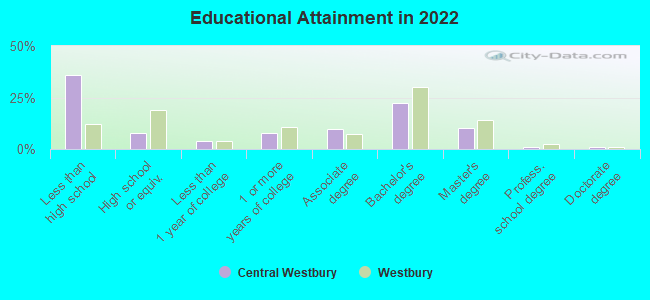
Education in this neighborhood (subdivision or community):
- Percentage of people 3 years and older in K-12 schools:
Central Westbury: 40.6% Westbury: 15.6%
- Percentage of people 3 years and older in undergraduate colleges:
Central Westbury: 2.5% Westbury: 3.0%
- Percentage of people 3 years and older in grad. or professional schools:
Central Westbury: 2.0% Westbury: 1.8%
- Percentage of students K-12 enrolled in private schools:
Central Westbury: 16.9% Westbury: 25.0%
Percentage of population below poverty level:
| Central Westbury: | 3.9% |
| Westbury: | 4.3% |
Median year owner moved in (as recorded in 2022):
| Central Westbury: | 2001 |
| Westbury: | 2003 |
Percentage of married-couple families with both working:
| Central Westbury: | 112.1% |
| Westbury: | 71.6% |
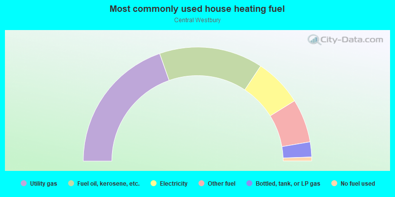
- 39.3%Utility gas
- 29.4%Fuel oil, kerosene, etc.
- 13.7%Electricity
- 12.3%Other fuel
- 4.3%Bottled, tank, or LP gas
- 1.1%No fuel used
Limited-access highways (interstate or state) in this neighborhood:
Wantagh State Pkwy
Length: 0.32 miles
Directions: E-W, SE-NW
Directions: E-W, SE-NW
Roads and streets:
Broadway
Length: 1.55 miles
Directions: E-W, SW-NE
Address range: 47 to 1130
Directions: E-W, SW-NE
Address range: 47 to 1130
Prospect Ave
Length: 1.34 miles
Direction: E-W
Address range: 634 to 1099
Direction: E-W
Address range: 634 to 1099
Railroad Ave
Length: 1.05 miles
Directions: E-W, N-S, SW-NE
Address range: 601 to 1007
Directions: E-W, N-S, SW-NE
Address range: 601 to 1007
Brush Hollow Rd
Length: 0.94 miles
Direction: SW-NE
Address range: 751 to 986
Direction: SW-NE
Address range: 751 to 986
Rockland St
Length: 0.89 miles
Direction: E-W
Address range: 409 to 799
Direction: E-W
Address range: 409 to 799
Union Ave
Length: 0.85 miles
Directions: E-W, SE-NW, SW-NE
Address range: 401 to 702
Directions: E-W, SE-NW, SW-NE
Address range: 401 to 702
Jefferson St
Length: 0.75 miles
Direction: E-W
Address range: 441 to 750
Direction: E-W
Address range: 441 to 750
Park Ave
Length: 0.62 miles
Direction: E-W
Address range: 800 to 999
Direction: E-W
Address range: 800 to 999
Cross St
Length: 0.61 miles
Direction: E-W
Address range: 381 to 599
Direction: E-W
Address range: 381 to 599
Oxford St
Length: 0.60 miles
Direction: E-W
Address range: 500 to 740
Direction: E-W
Address range: 500 to 740
Livingston St
Length: 0.60 miles
Direction: E-W
Address range: 493 to 750
Direction: E-W
Address range: 493 to 750
Grand Blvd
Length: 0.54 miles
Direction: SE-NW
Address range: 201 to 299
Direction: SE-NW
Address range: 201 to 299
Rutland St
Length: 0.52 miles
Direction: E-W
Address range: 450 to 676
Direction: E-W
Address range: 450 to 676
Franklin St
Length: 0.52 miles
Directions: E-W, SW-NE
Address range: 600 to 799
Directions: E-W, SW-NE
Address range: 600 to 799
School St
Length: 0.50 miles
Directions: N-S, SE-NW
Address range: 45 to 379
Directions: N-S, SE-NW
Address range: 45 to 379
Roman Ave
Length: 0.50 miles
Direction: E-W
Address range: 240 to 851
Direction: E-W
Address range: 240 to 851
Sheridan St
Length: 0.49 miles
Directions: N-S, SE-NW
Address range: 200 to 399
Directions: N-S, SE-NW
Address range: 200 to 399
Center St
Length: 0.49 miles
Directions: E-W, N-S, SE-NW
Address range: 101 to 510
Directions: E-W, N-S, SE-NW
Address range: 101 to 510
Maplewood Dr
Length: 0.46 miles
Direction: SE-NW
Address range: 1 to 210
Direction: SE-NW
Address range: 1 to 210
1st Ave
Length: 0.45 miles
Direction: SW-NE
Address range: 1 to 899
Direction: SW-NE
Address range: 1 to 899
Siegel St
Length: 0.44 miles
Directions: N-S, SE-NW
Address range: 200 to 399
Directions: N-S, SE-NW
Address range: 200 to 399
Dartmouth St
Length: 0.43 miles
Direction: E-W
Address range: 447 to 699
Direction: E-W
Address range: 447 to 699
Grand Ave
Length: 0.43 miles
Directions: E-W, N-S
Address range: 192 to 399
Directions: E-W, N-S
Address range: 192 to 399
Sherman St
Length: 0.42 miles
Direction: N-S
Address range: 200 to 372
Direction: N-S
Address range: 200 to 372
Urban Ave
Length: 0.42 miles
Direction: N-S
Address range: 140 to 299
Direction: N-S
Address range: 140 to 299
Brooklyn Ave
Length: 0.40 miles
Direction: N-S
Address range: 147 to 299
Direction: N-S
Address range: 147 to 299
Linden Ave
Length: 0.39 miles
Direction: N-S
Address range: 120 to 314
Direction: N-S
Address range: 120 to 314
Brook St
Length: 0.39 miles
Directions: N-S, SE-NW
Address range: 197 to 299
Directions: N-S, SE-NW
Address range: 197 to 299
4th Ave
Length: 0.36 miles
Directions: E-W, SW-NE
Address range: 1 to 99
Directions: E-W, SW-NE
Address range: 1 to 99
Powells Ln
Length: 0.36 miles
Direction: N-S
Address range: 313 to 477
Direction: N-S
Address range: 313 to 477
Garden St
Length: 0.36 miles
Direction: N-S
Address range: 100 to 299
Direction: N-S
Address range: 100 to 299
Circle Dr
Length: 0.35 miles
Directions: E-W, N-S, SE-NW, SW-NE
Address range: 1 to 99
Directions: E-W, N-S, SE-NW, SW-NE
Address range: 1 to 99
Kinkel St
Length: 0.35 miles
Direction: N-S
Address range: 130 to 299
Direction: N-S
Address range: 130 to 299
Hopper St
Length: 0.35 miles
Directions: N-S, SW-NE
Address range: 198 to 309
Directions: N-S, SW-NE
Address range: 198 to 309
Wright St
Length: 0.34 miles
Direction: N-S
Address range: 193 to 299
Direction: N-S
Address range: 193 to 299
State St
Length: 0.34 miles
Direction: N-S
Address range: 129 to 299
Direction: N-S
Address range: 129 to 299
Sylvester Ave (Sylvester St)
Length: 0.34 miles
Direction: N-S
Address range: 116 to 299
Direction: N-S
Address range: 116 to 299
New York Ave
Length: 0.34 miles
Direction: N-S
Address range: 123 to 299
Direction: N-S
Address range: 123 to 299
Rushmore St
Length: 0.32 miles
Directions: E-W, N-S
Address range: 121 to 299
Directions: E-W, N-S
Address range: 121 to 299
Monitor St
Length: 0.32 miles
Directions: N-S, SE-NW
Address range: 200 to 299
Directions: N-S, SE-NW
Address range: 200 to 299
Dover St
Length: 0.31 miles
Direction: E-W
Address range: 365 to 499
Direction: E-W
Address range: 365 to 499
Division St
Length: 0.30 miles
Direction: E-W
Address range: 1 to 99
Direction: E-W
Address range: 1 to 99
3rd Ave
Length: 0.30 miles
Direction: SW-NE
Address range: 1 to 99
Direction: SW-NE
Address range: 1 to 99
Cambridge Ave
Length: 0.29 miles
Direction: N-S
Address range: 300 to 499
Direction: N-S
Address range: 300 to 499
Magnolia Ave
Length: 0.29 miles
Direction: N-S
Address range: 130 to 375
Direction: N-S
Address range: 130 to 375
2nd Ave
Length: 0.29 miles
Directions: E-W, SW-NE
Address range: 1 to 99
Directions: E-W, SW-NE
Address range: 1 to 99
Bond St
Length: 0.29 miles
Direction: N-S
Address range: 100 to 299
Direction: N-S
Address range: 100 to 299
Newton St
Length: 0.28 miles
Direction: E-W
Address range: 360 to 499
Direction: E-W
Address range: 360 to 499
Winthrop St
Length: 0.28 miles
Direction: E-W
Address range: 364 to 499
Direction: E-W
Address range: 364 to 499
Madison St
Length: 0.28 miles
Direction: E-W
Address range: 409 to 499
Direction: E-W
Address range: 409 to 499
Maple Ave
Length: 0.28 miles
Direction: E-W
Address range: 362 to 499
Direction: E-W
Address range: 362 to 499
Upland St
Length: 0.28 miles
Directions: N-S, SE-NW
Address range: 342 to 710
Directions: N-S, SE-NW
Address range: 342 to 710
Swalm St
Length: 0.27 miles
Direction: N-S
Address range: 1 to 299
Direction: N-S
Address range: 1 to 299
Nassau St
Length: 0.25 miles
Direction: N-S
Address range: 203 to 399
Direction: N-S
Address range: 203 to 399
6th St
Length: 0.24 miles
Direction: SE-NW
Address range: 1 to 50
Direction: SE-NW
Address range: 1 to 50
Costar St
Length: 0.24 miles
Direction: N-S
Address range: 200 to 268
Direction: N-S
Address range: 200 to 268
Elizabeth St
Length: 0.24 miles
Direction: N-S
Address range: 149 to 224
Direction: N-S
Address range: 149 to 224
Clinton St
Length: 0.24 miles
Direction: E-W
Address range: 600 to 799
Direction: E-W
Address range: 600 to 799
Covert St
Length: 0.23 miles
Directions: N-S, SE-NW
Address range: 228 to 299
Directions: N-S, SE-NW
Address range: 228 to 299
King St
Length: 0.21 miles
Directions: N-S, SE-NW
Address range: 355 to 499
Directions: N-S, SE-NW
Address range: 355 to 499
Pearl St
Length: 0.20 miles
Direction: N-S
Address range: 148 to 1849
Direction: N-S
Address range: 148 to 1849
1st St
Length: 0.18 miles
Directions: N-S, SE-NW
Address range: 1 to 99
Directions: N-S, SE-NW
Address range: 1 to 99
Church St
Length: 0.18 miles
Directions: E-W, SE-NW, SW-NE
Address range: 500 to 599
Directions: E-W, SE-NW, SW-NE
Address range: 500 to 599
Linden Pl
Length: 0.17 miles
Direction: N-S
Address range: 300 to 399
Direction: N-S
Address range: 300 to 399
Francis Dr
Length: 0.17 miles
Directions: E-W, N-S, SE-NW, SW-NE
Address range: 1 to 99
Directions: E-W, N-S, SE-NW, SW-NE
Address range: 1 to 99
Hicksville Rd
Length: 0.17 miles
Direction: SE-NW
Address range: 1 to 46
Direction: SE-NW
Address range: 1 to 46
Hicks St
Length: 0.17 miles
Direction: SE-NW
Address range: 13 to 210
Direction: SE-NW
Address range: 13 to 210
Arbor Ln
Length: 0.15 miles
Directions: E-W, SE-NW, SW-NE
Address range: 1 to 17
Directions: E-W, SE-NW, SW-NE
Address range: 1 to 17
Talbot Dr
Length: 0.14 miles
Directions: N-S, SE-NW, SW-NE
Address range: 1 to 26
Directions: N-S, SE-NW, SW-NE
Address range: 1 to 26
2nd St
Length: 0.14 miles
Directions: E-W, N-S, SE-NW
Address range: 1 to 37
Directions: E-W, N-S, SE-NW
Address range: 1 to 37
Grant St
Length: 0.13 miles
Directions: E-W, SE-NW
Address range: 162 to 199
Directions: E-W, SE-NW
Address range: 162 to 199
Catherine St
Length: 0.13 miles
Direction: N-S
Address range: 1 to 199
Direction: N-S
Address range: 1 to 199
Willow St
Length: 0.12 miles
Direction: E-W
Address range: 400 to 452
Direction: E-W
Address range: 400 to 452
Northfield Ln
Length: 0.12 miles
Direction: E-W
Address range: 1 to 20
Direction: E-W
Address range: 1 to 20
Jaymie Dr
Length: 0.12 miles
Directions: N-S, SE-NW
Address range: 1 to 99
Directions: N-S, SE-NW
Address range: 1 to 99
Hillcrest Dr
Length: 0.11 miles
Directions: E-W, SE-NW, SW-NE
Address range: 1 to 99
Directions: E-W, SE-NW, SW-NE
Address range: 1 to 99
Garland Ln
Length: 0.11 miles
Direction: SW-NE
Address range: 1 to 50
Direction: SW-NE
Address range: 1 to 50
Floral Ln
Length: 0.11 miles
Direction: SW-NE
Address range: 1 to 44
Direction: SW-NE
Address range: 1 to 44
Walton Pl
Length: 0.11 miles
Direction: E-W
Address range: 400 to 499
Direction: E-W
Address range: 400 to 499
Bramble Ln
Length: 0.10 miles
Direction: SW-NE
Address range: 2 to 277
Direction: SW-NE
Address range: 2 to 277
Dogwood Ln
Length: 0.10 miles
Direction: SW-NE
Address range: 1 to 99
Direction: SW-NE
Address range: 1 to 99
Clover Ln
Length: 0.10 miles
Direction: SW-NE
Address range: 1 to 99
Direction: SW-NE
Address range: 1 to 99
Elderberry Ln
Length: 0.10 miles
Direction: SW-NE
Address range: 1 to 39
Direction: SW-NE
Address range: 1 to 39
Shomer Pl
Length: 0.10 miles
Directions: N-S, SE-NW
Address range: 264 to 279
Directions: N-S, SE-NW
Address range: 264 to 279
Princeton St
Length: 0.10 miles
Direction: N-S
Address range: 330 to 359
Direction: N-S
Address range: 330 to 359
3rd St
Length: 0.10 miles
Direction: SE-NW
Address range: 1 to 20
Direction: SE-NW
Address range: 1 to 20
Columbia St
Length: 0.10 miles
Direction: N-S
Address range: 300 to 399
Direction: N-S
Address range: 300 to 399
Melrick Ct
Length: 0.10 miles
Directions: E-W, N-S, SW-NE
Address range: 1 to 99
Directions: E-W, N-S, SW-NE
Address range: 1 to 99
Malaney Ave
Length: 0.09 miles
Directions: N-S, SE-NW
Address range: 201 to 626
Directions: N-S, SE-NW
Address range: 201 to 626
Portland Ave
Length: 0.09 miles
Direction: SW-NE
Address range: 1 to 99
Direction: SW-NE
Address range: 1 to 99
4th St
Length: 0.09 miles
Direction: SE-NW
Address range: 1 to 21
Direction: SE-NW
Address range: 1 to 21
Holly Ln
Length: 0.09 miles
Direction: SW-NE
Address range: 1 to 24
Direction: SW-NE
Address range: 1 to 24
Sullivan Ln
Length: 0.09 miles
Direction: SE-NW
Address range: 127 to 199
Direction: SE-NW
Address range: 127 to 199
5th St
Length: 0.08 miles
Direction: SE-NW
Address range: 1 to 21
Direction: SE-NW
Address range: 1 to 21
E Broadway St
Length: 0.08 miles
Direction: SW-NE
Address range: 1 to 157
Direction: SW-NE
Address range: 1 to 157
Rose Pl
Length: 0.07 miles
Directions: N-S, SE-NW
Address range: 342 to 399
Directions: N-S, SE-NW
Address range: 342 to 399
Juniper Ln
Length: 0.07 miles
Direction: SW-NE
Address range: 1 to 31
Direction: SW-NE
Address range: 1 to 31
Seaman Ct
Length: 0.05 miles
Direction: SE-NW
Address range: 225 to 246
Direction: SE-NW
Address range: 225 to 246
E Broadway
Length: 0.04 miles
Direction: SW-NE
Direction: SW-NE
Cassel Ct
Length: 0.04 miles
Direction: SW-NE
Address range: 1 to 11
Direction: SW-NE
Address range: 1 to 11
Spruce St
Length: 0.04 miles
Direction: N-S
Address range: 165 to 250
Direction: N-S
Address range: 165 to 250
Hill Crest Dr
Length: 0.03 miles
Direction: SE-NW
Direction: SE-NW
Westbury Hicksville Rd
Length: 0.02 miles
Direction: E-W
Direction: E-W
Railroad features:
Long Island RR
Length: 1.20 miles
Direction: E-W
Direction: E-W