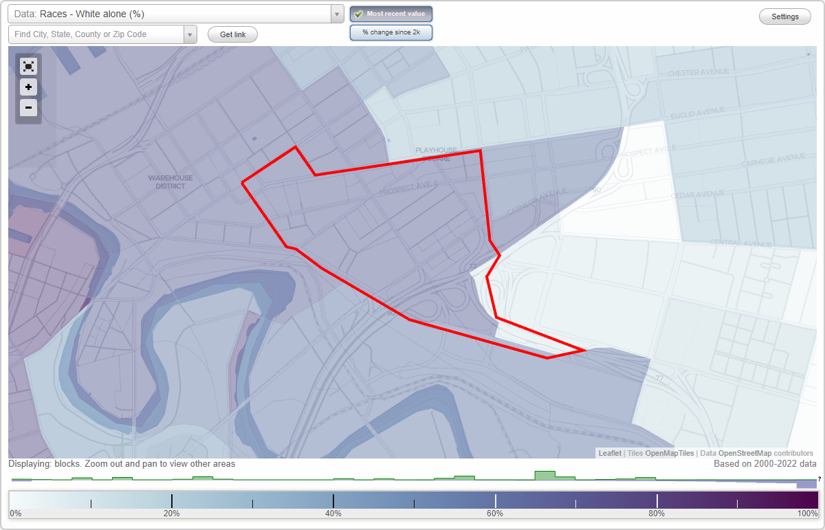
Gateway District neighborhood in Cleveland, Ohio (OH), 44115 detailed profile
Settings
X

Business Search - 14 Million verified businesses
Area: 0.336 square miles
City-data.com crime index for city in 2020 (higher means more crime):
| City: | 735.3 |
| U.S. average: | 219.5 |
Limited-access highways (interstate or state) in this neighborhood:
I- 77
Length: 0.48 miles
Directions: E-W, N-S, SE-NW
Directions: E-W, N-S, SE-NW
Northwest Fwy (I- 90)
Length: 0.47 miles
Directions: E-W, SW-NE
Directions: E-W, SW-NE
Highways in this neighborhood:
State Rte 14 (State Rte 43, S Broadway Ave)
Length: 0.56 miles
Directions: E-W, SE-NW
Address range: 420 to 1449
Directions: E-W, SE-NW
Address range: 420 to 1449
State Rte 8 (Orange Ave, US Hwy 422)
Length: 0.37 miles
Direction: E-W
Address range: 1400 to 2499
Direction: E-W
Address range: 1400 to 2499
Ontario St (State Rte 14, State Rte 43)
Length: 0.27 miles
Directions: E-W, SE-NW
Address range: 2200 to 2423
Directions: E-W, SE-NW
Address range: 2200 to 2423
US Hwy 20 (Euclid Ave)
Length: 0.23 miles
Directions: E-W, SW-NE
Address range: 2 to 521
Directions: E-W, SW-NE
Address range: 2 to 521
Roads and streets:
Prospect Ave E
Length: 0.74 miles
Direction: E-W
Address range: 100 to 1399
Direction: E-W
Address range: 100 to 1399
E 9th St
Length: 0.68 miles
Directions: N-S, SE-NW
Address range: 2000 to 2582
Directions: N-S, SE-NW
Address range: 2000 to 2582
Huron Rd E
Length: 0.55 miles
Directions: E-W, SW-NE
Address range: 1 to 1299
Directions: E-W, SW-NE
Address range: 1 to 1299
Carnegie Ave
Length: 0.50 miles
Direction: SW-NE
Address range: 524 to 1399
Direction: SW-NE
Address range: 524 to 1399
Bolivar Rd
Length: 0.49 miles
Direction: SW-NE
Address range: 300 to 1399
Direction: SW-NE
Address range: 300 to 1399
E 14th St
Length: 0.42 miles
Directions: N-S, SE-NW
Address range: 2050 to 2599
Directions: N-S, SE-NW
Address range: 2050 to 2599
Sumner Ave
Length: 0.29 miles
Direction: SW-NE
Address range: 900 to 1399
Direction: SW-NE
Address range: 900 to 1399
Erie Ct
Length: 0.29 miles
Direction: SW-NE
Address range: 900 to 1399
Direction: SW-NE
Address range: 900 to 1399
E 6th St
Length: 0.26 miles
Directions: E-W, N-S, SE-NW
Address range: 2050 to 2299
Directions: E-W, N-S, SE-NW
Address range: 2050 to 2299
Eagle Ave
Length: 0.26 miles
Direction: SW-NE
Address range: 100 to 899
Direction: SW-NE
Address range: 100 to 899
Bronson Ct
Length: 0.24 miles
Direction: SW-NE
Address range: 1000 to 1399
Direction: SW-NE
Address range: 1000 to 1399
E 4th St
Length: 0.20 miles
Directions: N-S, SE-NW
Address range: 2000 to 2299
Directions: N-S, SE-NW
Address range: 2000 to 2299
Webster Ave
Length: 0.20 miles
Direction: SW-NE
Address range: 900 to 1399
Direction: SW-NE
Address range: 900 to 1399
High Ave (High St)
Length: 0.18 miles
Directions: E-W, SW-NE
Address range: 100 to 599
Directions: E-W, SW-NE
Address range: 100 to 599
Gardner Ct
Length: 0.18 miles
Direction: SW-NE
Address range: 1000 to 1399
Direction: SW-NE
Address range: 1000 to 1399
E 12th St
Length: 0.17 miles
Directions: E-W, N-S, SE-NW
Address range: 2075 to 2459
Directions: E-W, N-S, SE-NW
Address range: 2075 to 2459
E 1st St
Length: 0.16 miles
Directions: N-S, SE-NW
Address range: 2000 to 2099
Directions: N-S, SE-NW
Address range: 2000 to 2099
E 8th St
Length: 0.15 miles
Directions: N-S, SE-NW
Address range: 2024 to 2199
Directions: N-S, SE-NW
Address range: 2024 to 2199
E 13th St
Length: 0.14 miles
Directions: E-W, SE-NW
Address range: 2300 to 2460
Directions: E-W, SE-NW
Address range: 2300 to 2460
Barn Ct
Length: 0.13 miles
Directions: E-W, SW-NE
Address range: 900 to 1199
Directions: E-W, SW-NE
Address range: 900 to 1199
Coleman Ct
Length: 0.11 miles
Direction: E-W
Address range: 200 to 599
Direction: E-W
Address range: 200 to 599
E 9th Pl
Length: 0.11 miles
Direction: SE-NW
Address range: 2100 to 2699
Direction: SE-NW
Address range: 2100 to 2699
Alpha Ct
Length: 0.11 miles
Directions: E-W, SW-NE
Address range: 700 to 899
Directions: E-W, SW-NE
Address range: 700 to 899
Brownell Ct
Length: 0.11 miles
Directions: E-W, SW-NE
Address range: 1200 to 1399
Directions: E-W, SW-NE
Address range: 1200 to 1399
E 3rd St
Length: 0.11 miles
Directions: N-S, SE-NW
Address range: 2000 to 2198
Directions: N-S, SE-NW
Address range: 2000 to 2198
E 7th St
Length: 0.10 miles
Direction: SE-NW
Address range: 2100 to 2399
Direction: SE-NW
Address range: 2100 to 2399
E 16th Pl
Length: 0.09 miles
Direction: SE-NW
Address range: 2100 to 2299
Direction: SE-NW
Address range: 2100 to 2299
E 12th Pl
Length: 0.07 miles
Directions: E-W, SE-NW
Address range: 2025 to 2082
Directions: E-W, SE-NW
Address range: 2025 to 2082
Caton Ct
Length: 0.07 miles
Direction: E-W
Address range: 1300 to 1599
Direction: E-W
Address range: 1300 to 1599
E 2nd St
Length: 0.05 miles
Direction: N-S
Address range: 2000 to 2199
Direction: N-S
Address range: 2000 to 2199
E 22nd St
Length: 0.04 miles
Directions: N-S, SW-NE
Address range: 2632 to 2699
Directions: N-S, SW-NE
Address range: 2632 to 2699
Huntington Ct
Length: 0.04 miles
Direction: SW-NE
Address range: 1400 to 1599
Direction: SW-NE
Address range: 1400 to 1599
E 10th St
Length: 0.03 miles
Direction: SE-NW
Address range: 2400 to 2498
Direction: SE-NW
Address range: 2400 to 2498
E 10th Pl
Length: 0.03 miles
Direction: SE-NW
Address range: 2300 to 2351
Direction: SE-NW
Address range: 2300 to 2351