Glenloch neighborhood in Peachtree City, Georgia (GA), 30215, 30269 detailed profile
Settings
X


Business Search - 14 Million verified businesses
Area: 3.722 square miles
Population: 3,329
Population density:
| Glenloch: | 894 people per square mile |
| Peachtree City: | 1,651 people per square mile |

- 2,66264.0%White
- 43810.5%Some other race
- 4089.8%Asian
- 2576.2%Hispanic or Latino
- 1714.1%Two or more races
- 1453.5%American Indian
- 761.8%Black

Median household income in 2022:
| Glenloch: | $110,570 |
| Peachtree City: | $111,850 |
Distribution of median household income
![Distribution of median household income]()
- 75Less than $10,000
- 305$10,000 to $19,999
- 398$20,000 to $29,999
- 98$30,000 to $39,999
- 300$40,000 to $49,999
- 23$50,000 to $59,999
- 117$60,000 to $74,999
- 244$75,000 to $99,999
- 245$100,000 to $124,999
- 75$125,000 to $149,999
- 171$150,000 to $199,999
- 144$200,000 or more

Distribution of owner-occupied house/condo value
![Distribution of owner-occupied house/condo value]()
- 132Less than $50,000
- 140$50,000 to $99,999
- 27$100,000 to $149,999
- 27$150,000 to $199,999
- 60$200,000 to $249,999
- 55$250,000 to $299,999
- 400$300,000 to $399,999
- 303$400,000 to $499,999
- 153$500,000 to $749,999
- 223$750,000 to $999,999
- 335$1,000,000 or more

Distribution of rent paid by renters
![Distribution of rent paid by renters]()
- 19$100 to $199
- 170$300 to $399
- 57$400 to $499
- 7$500 to $599
- 25$900 to $999
- 60$1,000 to $1,249
- 91$1,250 to $1,499
- 140$1,500 to $1,999
- 96$2,000 or more

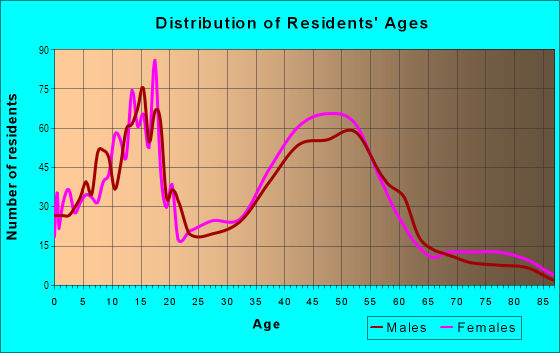
| Males: | 1,724 |
| Females: | 1,605 |
Males:
| This neighborhood: | 42.8 years |
| Whole city: | 43.5 years |
| This neighborhood: | 42.7 years |
| Whole city: | 45.3 years |
Average household size:
| Glenloch: | 2.8 people |
| Peachtree City: | 2.6 people |
Percentage of family households:
| Glenloch: | 45.4% |
| Peachtree City: | 53.9% |
| Here: | 65.7% |
| Peachtree City: | 64.3% |
Percentage of married-couple families with children (among all households):
| Glenloch: | 28.0% |
| Peachtree City: | 31.4% |
Percentage of single-mother households (among all households):
| Glenloch: | 12.4% |
| Peachtree City: | 5.3% |
Percentage of never married males 15 years old and over:
Percentage of never married females 15 years old and over:
| Glenloch: | 12.4% |
| Peachtree City: | 11.8% |
Percentage of never married females 15 years old and over:
| Glenloch: | 8.2% |
| city: | 11.6% |
Percentage of people that speak English not well or not at all:
| Glenloch: | 1.4% |
| Peachtree City: | 2.1% |
Percentage of people born in this state:
Percentage of people born in another U.S. state:
Percentage of native residents but born outside the U.S.:
Percentage of foreign born residents:
| Here: | 23.5% |
| Peachtree City: | 26.5% |
Percentage of people born in another U.S. state:
| Glenloch: | 56.3% |
| Peachtree City: | 55.4% |
Percentage of native residents but born outside the U.S.:
| Here: | 3.8% |
| city: | 3.0% |
Percentage of foreign born residents:
| Here: | 16.4% |
| Peachtree City: | 15.1% |
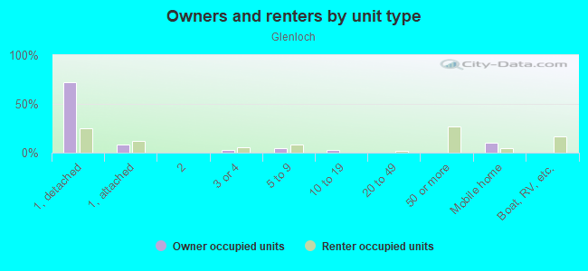
Owner-occupied
Renter-occupied

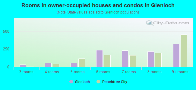
- Rooms in owner-occupied houses and condos in Glenloch
- 01 room
- 02 rooms
- 343 rooms
- 534 rooms
- 575 rooms
- 2346 rooms
- 2297 rooms
- 2178 rooms
- 3259+ rooms
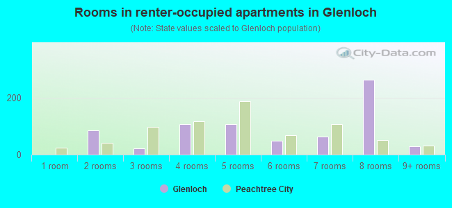
- Rooms in renter-occupied apartments in Glenloch
- 01 room
- 872 rooms
- 233 rooms
- 1084 rooms
- 1085 rooms
- 496 rooms
- 637 rooms
- 2658 rooms
- 299+ rooms
Owner-occupied
Renter-occupied
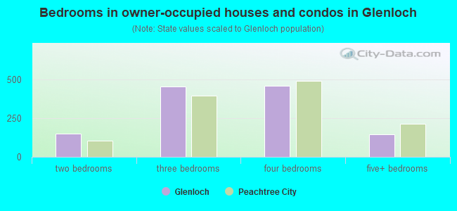
- Bedrooms in owner-occupied houses and condos in Glenloch
- 0no bedroom
- 01 bedroom
- 1512 bedrooms
- 4523 bedrooms
- 4574 bedrooms
- 1435+ bedrooms
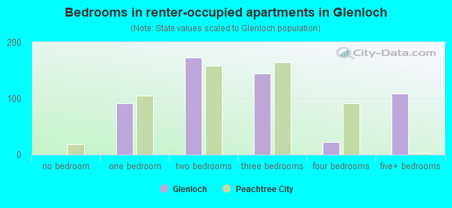
- Bedrooms in renter-occupied apartments in Glenloch
- 0no bedroom
- 911 bedroom
- 1732 bedrooms
- 1443 bedrooms
- 224 bedrooms
- 1095+ bedrooms
Average number of cars or other vehicles available in houses/condos:
Average number of cars or other vehicles available in apartments:
| This neighborhood: | 1.1 |
| Peachtree City: | 2.2 |
Average number of cars or other vehicles available in apartments:
| Here: | 1.5 |
| city: | 1.4 |
Percentage of units with a mortgage:
| Glenloch: | 60.1% |
| Peachtree City: | 68.2% |
Average estimated value of detached houses in 2022 (88.7% of all units):
| Glenloch: | $426,196 |
| Georgia: | $376,364 |
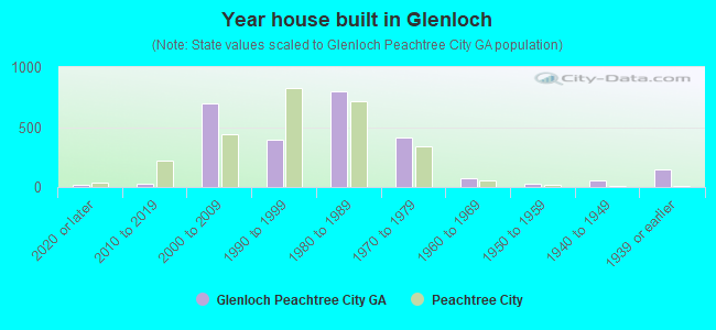
- Year house built in Glenloch
- 152020 or later
- 292010 to 2019
- 7012000 to 2009
- 3921990 to 1999
- 7971980 to 1989
- 4151970 to 1979
- 771960 to 1969
- 281950 to 1959
- 521940 to 1949
- 1451939 or earlier
City-data.com crime index for city in 2020 (higher means more crime):
| City: | 68.3 |
| U.S. average: | 219.5 |
Travel time to work (commute)
![Travel time to work (commute)]()
- 32Less than 5 minutes
- 2565 to 9 minutes
- 19010 to 14 minutes
- 18815 to 19 minutes
- 13220 to 24 minutes
- 6725 to 29 minutes
- 24930 to 34 minutes
- 2835 to 39 minutes
- 3440 to 44 minutes
- 14245 to 59 minutes
- 13260 to 89 minutes
- 5490 or more minutes

Means of transportation to work
![Means of transportation to work]()
- 74.6%895Drove a car alone
- 1.1%13Carpooled
- 3.0%36Subway or elevated rail
- 0.9%11Light rail, streetcar or trolley
- 1.1%13Taxi
- 15.2%182Walked
- 18.3%219Other means
- 18.6%223Worked at home

Time leaving home to go to work
![Time leaving home to go to work]()
- 5612:00 a.m. to 4:59 a.m.
- 845:00 a.m. to 5:29 a.m.
- 1145:30 a.m. to 5:59 a.m.
- 1526:00 a.m. to 6:29 a.m.
- 676:30 a.m. to 6:59 a.m.
- 1787:00 a.m. to 7:29 a.m.
- 2427:30 a.m. to 7:59 a.m.
- 2498:00 a.m. to 8:29 a.m.
- 708:30 a.m. to 8:59 a.m.
- 1119:00 a.m. to 9:59 a.m.
- 2810:00 a.m. to 10:59 a.m.
- 5111:00 a.m. to 11:59 a.m.
- 8712:00 p.m. to 3:59 p.m.
- 974:00 p.m. to 11:59 p.m.

Occupations of males:
- Percentage of males in management occupations (except farmers):
Here: 25.4% city: 24.3%
- Percentage of males in business and financial operations occupations:
Here: 3.0% city: 5.8%
- Percentage of males in computer and mathematical occupations:
Here: 1.9% city: 5.7%
- Percentage of males in architecture and engineering occupations:
Here: 1.8% city: 7.2%
- Percentage of males in community and social services occupations:
Here: 1.2% city: 0.9%
- Percentage of males in education, training, and library occupations:
Here: 1.2% city: 2.1%
- Percentage of males in arts, design, entertainment, sports, and media occupations:
Here: 11.0% city: 2.2%
- Percentage of males in healthcare practitioners and technical occupations:
Here: 9.8% city: 4.7%
- Percentage of males in service occupations:
Here: 17.1% city: 10.6%
- Percentage of males in sales and office occupations:
Here: 13.3% city: 13.2%
- Percentage of males in transportation occupations:
Here: 4.4% city: 10.3%
- Percentage of males in material moving occupations:
Here: 4.0% city: 0.8%
Occupations of females:
- Percentage of females in management occupations (except farmers):
Here: 21.9% city: 15.0%
- Percentage of females in business and financial operations occupations:
Here: 1.2% city: 7.2%
- Percentage of females in education, training, and library occupations:
Here: 5.9% city: 14.8%
- Percentage of females in arts, design, entertainment, sports, and media occupations:
Here: 3.9% city: 4.4%
- Percentage of females in healthcare practitioners and technical occupations:
Here: 19.6% city: 11.5%
- Percentage of females in service occupations:
Here: 14.2% city: 11.7%
- Percentage of females in sales and office occupations:
Here: 24.7% city: 22.6%
- Percentage of females in production occupations:
Here: 13.2% city: 1.6%
- Percentage of females in material moving occupations:
Here: 6.0% city: 0.7%
Percentage of people 16-64 in Armed Forces:
| Glenloch: | 0.1% |
| Peachtree City: | 0.0% |
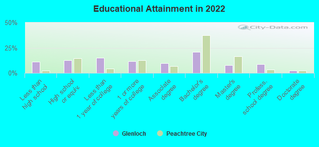
Education in this neighborhood (subdivision or community):
- Percentage of people 3 years and older in K-12 schools:
Glenloch: 29.3% Peachtree City: 21.2%
- Percentage of people 3 years and older in undergraduate colleges:
Glenloch: 3.9% Peachtree City: 4.1%
- Percentage of people 3 years and older in grad. or professional schools:
Glenloch: 4.7% Peachtree City: 1.4%
- Percentage of students K-12 enrolled in private schools:
Glenloch: 61.1% Peachtree City: 10.5%
Percentage of population below poverty level:
| Glenloch: | 9.0% |
| Peachtree City: | 5.8% |
Median year owner moved in (as recorded in 2022):
| Glenloch: | 2004 |
| Peachtree City: | 2010 |
Percentage of married-couple families with both working:
| Glenloch: | 84.7% |
| Peachtree City: | 60.5% |
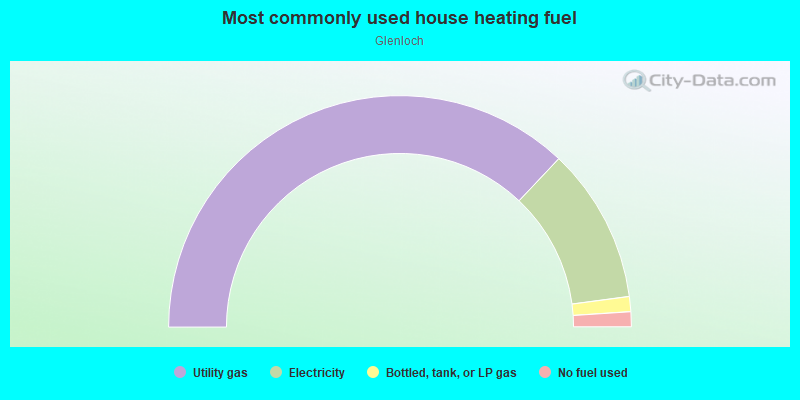
- 74.1%Utility gas
- 21.7%Electricity
- 2.1%Bottled, tank, or LP gas
- 2.1%No fuel used
Highways in this neighborhood:
State Rte 54 (W Lanier Ave)
Length: 3.56 miles
Directions: E-W, N-S, SW-NE
Address range: 2200 to 2499
Directions: E-W, N-S, SW-NE
Address range: 2200 to 2499
Roads and streets:
Robbinson Rd
Length: 2.01 miles
Directions: E-W, N-S, SE-NW
Address range: 200 to 498
Directions: E-W, N-S, SE-NW
Address range: 200 to 498
McIntosh Trl
Length: 1.90 miles
Directions: E-W, SW-NE
Address range: 100 to 297
Directions: E-W, SW-NE
Address range: 100 to 297
S Peachtree Pkwy
Length: 1.37 miles
Directions: N-S, SE-NW, SW-NE
Address range: 118 to 499
Directions: N-S, SE-NW, SW-NE
Address range: 118 to 499
Stevens Entry
Length: 1.10 miles
Directions: E-W, N-S, SE-NW, SW-NE
Address range: 200 to 1099
Directions: E-W, N-S, SE-NW, SW-NE
Address range: 200 to 1099
Windgate Rd
Length: 1.06 miles
Directions: E-W, SE-NW, SW-NE
Address range: 400 to 699
Directions: E-W, SE-NW, SW-NE
Address range: 400 to 699
Waterwood Bend
Length: 1.01 miles
Directions: E-W, N-S, SE-NW, SW-NE
Address range: 100 to 799
Directions: E-W, N-S, SE-NW, SW-NE
Address range: 100 to 799
N Peachtree Pkwy
Length: 1.00 miles
Directions: E-W, N-S, SE-NW, SW-NE
Address range: 100 to 401
Directions: E-W, N-S, SE-NW, SW-NE
Address range: 100 to 401
Camp Creek Trl
Length: 0.99 miles
Directions: E-W, N-S, SE-NW, SW-NE
Address range: 100 to 299
Directions: E-W, N-S, SE-NW, SW-NE
Address range: 100 to 299
Doubletrace Ln
Length: 0.88 miles
Directions: E-W, N-S, SE-NW, SW-NE
Address range: 100 to 699
Directions: E-W, N-S, SE-NW, SW-NE
Address range: 100 to 699
Fishers Luck
Length: 0.82 miles
Directions: E-W, N-S, SE-NW, SW-NE
Directions: E-W, N-S, SE-NW, SW-NE
Saltlick Trce
Length: 0.80 miles
Directions: E-W, N-S, SE-NW, SW-NE
Address range: 100 to 609
Directions: E-W, N-S, SE-NW, SW-NE
Address range: 100 to 609
Bridal Path Ln
Length: 0.73 miles
Directions: E-W, N-S, SE-NW
Address range: 101 to 511
Directions: E-W, N-S, SE-NW
Address range: 101 to 511
Stagecoach Rd
Length: 0.64 miles
Directions: E-W, SE-NW
Address range: 301 to 399
Directions: E-W, SE-NW
Address range: 301 to 399
Battery Way
Length: 0.59 miles
Directions: E-W, N-S, SE-NW, SW-NE
Address range: 100 to 299
Directions: E-W, N-S, SE-NW, SW-NE
Address range: 100 to 299
Shadowood Ln
Length: 0.56 miles
Directions: E-W, N-S, SE-NW, SW-NE
Address range: 100 to 226
Directions: E-W, N-S, SE-NW, SW-NE
Address range: 100 to 226
Raintree Bend
Length: 0.55 miles
Directions: E-W, N-S, SE-NW
Address range: 104 to 499
Directions: E-W, N-S, SE-NW
Address range: 104 to 499
Montclair Dr
Length: 0.52 miles
Directions: E-W, N-S, SE-NW, SW-NE
Address range: 1100 to 1127
Directions: E-W, N-S, SE-NW, SW-NE
Address range: 1100 to 1127
Lakeside Dr
Length: 0.51 miles
Directions: E-W, N-S, SE-NW, SW-NE
Address range: 100 to 199
Directions: E-W, N-S, SE-NW, SW-NE
Address range: 100 to 199
Morgans Turn
Length: 0.48 miles
Directions: E-W, N-S, SE-NW, SW-NE
Address range: 100 to 399
Directions: E-W, N-S, SE-NW, SW-NE
Address range: 100 to 399
Creekstone Bend
Length: 0.48 miles
Directions: N-S, SE-NW, SW-NE
Address range: 100 to 299
Directions: N-S, SE-NW, SW-NE
Address range: 100 to 299
Harbor Loop
Length: 0.47 miles
Directions: E-W, N-S, SW-NE
Address range: 100 to 499
Directions: E-W, N-S, SW-NE
Address range: 100 to 499
Martingale Dr
Length: 0.43 miles
Directions: E-W, N-S, SE-NW, SW-NE
Address range: 100 to 499
Directions: E-W, N-S, SE-NW, SW-NE
Address range: 100 to 499
Prime Pt
Length: 0.42 miles
Directions: E-W, N-S, SW-NE
Address range: 201 to 499
Directions: E-W, N-S, SW-NE
Address range: 201 to 499
Carriage Ln
Length: 0.41 miles
Directions: E-W, N-S, SE-NW
Address range: 104 to 199
Directions: E-W, N-S, SE-NW
Address range: 104 to 199
Whitfield Run Rd
Length: 0.39 miles
Directions: E-W, N-S, SW-NE
Directions: E-W, N-S, SW-NE
Larkspur Turn
Length: 0.38 miles
Directions: N-S, SE-NW, SW-NE
Address range: 200 to 399
Directions: N-S, SE-NW, SW-NE
Address range: 200 to 399
Highgreen Ridge
Length: 0.38 miles
Directions: N-S, SE-NW, SW-NE
Address range: 100 to 199
Directions: N-S, SE-NW, SW-NE
Address range: 100 to 199
Spear Rd
Length: 0.37 miles
Directions: E-W, SW-NE
Address range: 266 to 312
Directions: E-W, SW-NE
Address range: 266 to 312
Scatterfoot Dr
Length: 0.35 miles
Directions: E-W, N-S, SW-NE
Address range: 100 to 199
Directions: E-W, N-S, SW-NE
Address range: 100 to 199
Groveland Dr
Length: 0.35 miles
Directions: E-W, N-S, SE-NW, SW-NE
Address range: 100 to 299
Directions: E-W, N-S, SE-NW, SW-NE
Address range: 100 to 299
Clydesdale Rd
Length: 0.33 miles
Directions: N-S, SE-NW, SW-NE
Address range: 100 to 299
Directions: N-S, SE-NW, SW-NE
Address range: 100 to 299
Layor Ct
Length: 0.32 miles
Directions: N-S, SE-NW
Directions: N-S, SE-NW
Petrol Pt
Length: 0.31 miles
Directions: N-S, SE-NW, SW-NE
Address range: 100 to 399
Directions: N-S, SE-NW, SW-NE
Address range: 100 to 399
Pennfair Dr
Length: 0.30 miles
Directions: E-W, N-S, SE-NW
Address range: 1400 to 1421
Directions: E-W, N-S, SE-NW
Address range: 1400 to 1421
Planceer Pl
Length: 0.29 miles
Direction: SW-NE
Address range: 200 to 399
Direction: SW-NE
Address range: 200 to 399
Greensway
Length: 0.28 miles
Direction: E-W
Address range: 100 to 299
Direction: E-W
Address range: 100 to 299
Journeys End
Length: 0.28 miles
Directions: N-S, SW-NE
Address range: 100 to 499
Directions: N-S, SW-NE
Address range: 100 to 499
Hedgewood Ln
Length: 0.27 miles
Direction: SE-NW
Address range: 100 to 224
Direction: SE-NW
Address range: 100 to 224
Sweetwater Oaks
Length: 0.27 miles
Directions: E-W, N-S, SE-NW, SW-NE
Address range: 100 to 199
Directions: E-W, N-S, SE-NW, SW-NE
Address range: 100 to 199
Woodland Dr
Length: 0.27 miles
Directions: E-W, N-S, SW-NE
Address range: 100 to 299
Directions: E-W, N-S, SW-NE
Address range: 100 to 299
Skiff Trce
Length: 0.27 miles
Directions: N-S, SE-NW
Address range: 200 to 399
Directions: N-S, SE-NW
Address range: 200 to 399
Shakerag Hill
Length: 0.27 miles
Directions: E-W, N-S, SE-NW, SW-NE
Address range: 2000 to 7999
Directions: E-W, N-S, SE-NW, SW-NE
Address range: 2000 to 7999
Edgewater Way
Length: 0.26 miles
Directions: E-W, N-S, SE-NW
Address range: 100 to 299
Directions: E-W, N-S, SE-NW
Address range: 100 to 299
Presidio Park
Length: 0.26 miles
Direction: SW-NE
Address range: 100 to 116
Direction: SW-NE
Address range: 100 to 116
Eastbrook Bend
Length: 0.26 miles
Directions: E-W, SE-NW, SW-NE
Address range: 1 to 95
Directions: E-W, SE-NW, SW-NE
Address range: 1 to 95
Peachtree Pkwy
Length: 0.25 miles
Directions: N-S, SW-NE
Directions: N-S, SW-NE
Highlands Way
Length: 0.25 miles
Directions: E-W, N-S, SW-NE
Address range: 100 to 199
Directions: E-W, N-S, SW-NE
Address range: 100 to 199
Crossings W
Length: 0.25 miles
Directions: SE-NW, SW-NE
Directions: SE-NW, SW-NE
Van Ness
Length: 0.25 miles
Direction: SE-NW
Address range: 100 to 299
Direction: SE-NW
Address range: 100 to 299
Bowfin Bay
Length: 0.24 miles
Direction: E-W
Address range: 100 to 130
Direction: E-W
Address range: 100 to 130
Grenoble Rd
Length: 0.23 miles
Directions: E-W, N-S, SE-NW, SW-NE
Address range: 100 to 199
Directions: E-W, N-S, SE-NW, SW-NE
Address range: 100 to 199
Broken Bit Way
Length: 0.20 miles
Directions: E-W, N-S, SE-NW
Address range: 101 to 399
Directions: E-W, N-S, SE-NW
Address range: 101 to 399
Fountain Head
Length: 0.20 miles
Directions: E-W, SW-NE
Address range: 100 to 199
Directions: E-W, SW-NE
Address range: 100 to 199
Rosemont
Length: 0.19 miles
Directions: E-W, N-S, SE-NW, SW-NE
Address range: 100 to 199
Directions: E-W, N-S, SE-NW, SW-NE
Address range: 100 to 199
Forest View Dr
Length: 0.18 miles
Directions: E-W, N-S, SE-NW
Address range: 100 to 117
Directions: E-W, N-S, SE-NW
Address range: 100 to 117
Lake Forest Dr
Length: 0.18 miles
Directions: E-W, N-S, SE-NW, SW-NE
Address range: 100 to 199
Directions: E-W, N-S, SE-NW, SW-NE
Address range: 100 to 199
Windgate Ct
Length: 0.17 miles
Direction: N-S
Address range: 200 to 299
Direction: N-S
Address range: 200 to 299
Silverwood Way
Length: 0.16 miles
Directions: E-W, SE-NW
Address range: 100 to 299
Directions: E-W, SE-NW
Address range: 100 to 299
Wysteria Ct
Length: 0.15 miles
Directions: E-W, SE-NW
Address range: 200 to 409
Directions: E-W, SE-NW
Address range: 200 to 409
Whisper Trce
Length: 0.15 miles
Directions: E-W, N-S, SE-NW, SW-NE
Address range: 100 to 199
Directions: E-W, N-S, SE-NW, SW-NE
Address range: 100 to 199
Raintree Hill
Length: 0.15 miles
Directions: E-W, N-S, SW-NE
Address range: 502 to 599
Directions: E-W, N-S, SW-NE
Address range: 502 to 599
Spring Walk
Length: 0.15 miles
Directions: N-S, SE-NW
Address range: 300 to 399
Directions: N-S, SE-NW
Address range: 300 to 399
Hearthstone Reach
Length: 0.15 miles
Directions: N-S, SE-NW
Address range: 100 to 299
Directions: N-S, SE-NW
Address range: 100 to 299
Saddlebrook Dr
Length: 0.15 miles
Directions: E-W, SE-NW
Address range: 100 to 199
Directions: E-W, SE-NW
Address range: 100 to 199
Southwind Reach
Length: 0.15 miles
Directions: N-S, SE-NW
Address range: 100 to 199
Directions: N-S, SE-NW
Address range: 100 to 199
Timber Ridge
Length: 0.15 miles
Directions: E-W, N-S, SE-NW
Address range: 100 to 199
Directions: E-W, N-S, SE-NW
Address range: 100 to 199
Lakewood Ln
Length: 0.14 miles
Directions: N-S, SE-NW
Address range: 500 to 699
Directions: N-S, SE-NW
Address range: 500 to 699
Sandtrap Ridge
Length: 0.14 miles
Directions: N-S, SW-NE
Address range: 100 to 199
Directions: N-S, SW-NE
Address range: 100 to 199
Warmstone Path
Length: 0.14 miles
Directions: E-W, SW-NE
Address range: 100 to 199
Directions: E-W, SW-NE
Address range: 100 to 199
Gleneagle Point Rd
Length: 0.13 miles
Directions: N-S, SE-NW, SW-NE
Directions: N-S, SE-NW, SW-NE
Driftwood Ln
Length: 0.13 miles
Directions: E-W, N-S, SE-NW, SW-NE
Address range: 200 to 225
Directions: E-W, N-S, SE-NW, SW-NE
Address range: 200 to 225
Perch Pt
Length: 0.13 miles
Direction: E-W
Address range: 100 to 199
Direction: E-W
Address range: 100 to 199
Fern Vale
Length: 0.12 miles
Direction: E-W
Address range: 100 to 298
Direction: E-W
Address range: 100 to 298
Beacon Tree Way
Length: 0.12 miles
Direction: SE-NW
Address range: 100 to 299
Direction: SE-NW
Address range: 100 to 299
Davis Rd
Length: 0.12 miles
Directions: N-S, SE-NW
Directions: N-S, SE-NW
Lanyard Loop
Length: 0.12 miles
Directions: N-S, SE-NW
Address range: 200 to 299
Directions: N-S, SE-NW
Address range: 200 to 299
Hamilton Dr
Length: 0.12 miles
Directions: E-W, N-S, SE-NW, SW-NE
Address range: 100 to 123
Directions: E-W, N-S, SE-NW, SW-NE
Address range: 100 to 123
Paddock Trl
Length: 0.11 miles
Directions: N-S, SE-NW, SW-NE
Address range: 100 to 199
Directions: N-S, SE-NW, SW-NE
Address range: 100 to 199
Brookwood Path
Length: 0.11 miles
Directions: E-W, SW-NE
Address range: 100 to 199
Directions: E-W, SW-NE
Address range: 100 to 199
Lanyard Bend
Length: 0.11 miles
Directions: E-W, N-S, SE-NW
Address range: 100 to 199
Directions: E-W, N-S, SE-NW
Address range: 100 to 199
Lake Aires
Length: 0.11 miles
Directions: N-S, SE-NW
Address range: 100 to 199
Directions: N-S, SE-NW
Address range: 100 to 199
Rose Wood Dr
Length: 0.11 miles
Direction: N-S
Address range: 101 to 117
Direction: N-S
Address range: 101 to 117
Banks Run
Length: 0.11 miles
Directions: N-S, SW-NE
Address range: 100 to 299
Directions: N-S, SW-NE
Address range: 100 to 299
Nettlecure Ct
Length: 0.11 miles
Directions: N-S, SE-NW
Address range: 100 to 199
Directions: N-S, SE-NW
Address range: 100 to 199
Rose Wood Ct
Length: 0.11 miles
Direction: SE-NW
Address range: 100 to 116
Direction: SE-NW
Address range: 100 to 116
Robinson Ct
Length: 0.10 miles
Directions: E-W, SE-NW, SW-NE
Address range: 100 to 304
Directions: E-W, SE-NW, SW-NE
Address range: 100 to 304
Gleneagles Pt
Length: 0.10 miles
Direction: SE-NW
Address range: 100 to 299
Direction: SE-NW
Address range: 100 to 299
Atwater Park
Length: 0.10 miles
Direction: SW-NE
Direction: SW-NE
Jumpers Run
Length: 0.10 miles
Directions: E-W, SE-NW
Address range: 100 to 199
Directions: E-W, SE-NW
Address range: 100 to 199
Whitfield Ct
Length: 0.10 miles
Directions: E-W, SE-NW
Address range: 100 to 499
Directions: E-W, SE-NW
Address range: 100 to 499
Nightwind Ct
Length: 0.10 miles
Direction: E-W
Address range: 100 to 199
Direction: E-W
Address range: 100 to 199
Parsons Pl
Length: 0.10 miles
Direction: E-W
Address range: 100 to 199
Direction: E-W
Address range: 100 to 199
Greenblade Pt
Length: 0.10 miles
Direction: SE-NW
Address range: 100 to 199
Direction: SE-NW
Address range: 100 to 199
Gelding Garth
Length: 0.10 miles
Direction: E-W
Address range: 100 to 199
Direction: E-W
Address range: 100 to 199
Cove Rd
Length: 0.09 miles
Directions: E-W, SE-NW
Address range: 700 to 799
Directions: E-W, SE-NW
Address range: 700 to 799
Ketch Ct
Length: 0.09 miles
Directions: E-W, SW-NE
Address range: 100 to 199
Directions: E-W, SW-NE
Address range: 100 to 199
Nob Hill Rd
Length: 0.09 miles
Directions: E-W, SE-NW
Address range: 100 to 114
Directions: E-W, SE-NW
Address range: 100 to 114
Fox Fall
Length: 0.09 miles
Directions: N-S, SE-NW, SW-NE
Address range: 101 to 199
Directions: N-S, SE-NW, SW-NE
Address range: 101 to 199
Cornflower Ct
Length: 0.08 miles
Directions: N-S, SE-NW
Address range: 100 to 199
Directions: N-S, SE-NW
Address range: 100 to 199
Ridge Vw
Length: 0.08 miles
Directions: E-W, SE-NW
Address range: 100 to 126
Directions: E-W, SE-NW
Address range: 100 to 126
Tivoli Gardens Rd
Length: 0.08 miles
Directions: E-W, SW-NE
Address range: 100 to 399
Directions: E-W, SW-NE
Address range: 100 to 399
Loxley Cir
Length: 0.08 miles
Directions: N-S, SW-NE
Address range: 1200 to 1210
Directions: N-S, SW-NE
Address range: 1200 to 1210
Palamino Path
Length: 0.08 miles
Directions: N-S, SW-NE
Address range: 100 to 114
Directions: N-S, SW-NE
Address range: 100 to 114
Robinson Rd
Length: 0.08 miles
Direction: SE-NW
Direction: SE-NW
Tuliptree Ter
Length: 0.08 miles
Directions: E-W, SE-NW
Address range: 100 to 199
Directions: E-W, SE-NW
Address range: 100 to 199
Silver Spr
Length: 0.08 miles
Directions: E-W, N-S, SE-NW, SW-NE
Address range: 100 to 109
Directions: E-W, N-S, SE-NW, SW-NE
Address range: 100 to 109
Bentwood Ct
Length: 0.08 miles
Directions: E-W, N-S, SE-NW
Directions: E-W, N-S, SE-NW
Gateway Point Rd
Length: 0.07 miles
Direction: N-S
Address range: 100 to 116
Direction: N-S
Address range: 100 to 116
Lake Pt
Length: 0.07 miles
Direction: SW-NE
Address range: 100 to 113
Direction: SW-NE
Address range: 100 to 113
Sandown Dr
Length: 0.07 miles
Direction: SE-NW
Address range: 100 to 198
Direction: SE-NW
Address range: 100 to 198
Spincast Ct
Length: 0.07 miles
Direction: E-W
Address range: 100 to 199
Direction: E-W
Address range: 100 to 199
Shadylawn Ct
Length: 0.07 miles
Direction: SW-NE
Address range: 100 to 199
Direction: SW-NE
Address range: 100 to 199
Postwood Turn
Length: 0.07 miles
Direction: SE-NW
Address range: 100 to 199
Direction: SE-NW
Address range: 100 to 199
Williams Cir
Length: 0.07 miles
Directions: E-W, SE-NW
Address range: 1200 to 1299
Directions: E-W, SE-NW
Address range: 1200 to 1299
Moss Hill Ct
Length: 0.07 miles
Direction: SW-NE
Address range: 100 to 199
Direction: SW-NE
Address range: 100 to 199
Eden Edge
Length: 0.07 miles
Direction: SE-NW
Address range: 100 to 113
Direction: SE-NW
Address range: 100 to 113
Blue Grass Trce
Length: 0.07 miles
Direction: E-W
Address range: 100 to 110
Direction: E-W
Address range: 100 to 110
Windbreak Path
Length: 0.06 miles
Direction: E-W
Address range: 100 to 199
Direction: E-W
Address range: 100 to 199
Pine Cone Break
Length: 0.06 miles
Direction: SW-NE
Address range: 100 to 199
Direction: SW-NE
Address range: 100 to 199
Garret Ridge
Length: 0.06 miles
Direction: SE-NW
Address range: 101 to 199
Direction: SE-NW
Address range: 101 to 199
Timber Walk
Length: 0.06 miles
Direction: E-W
Address range: 100 to 199
Direction: E-W
Address range: 100 to 199
Jasmine Path
Length: 0.06 miles
Direction: SW-NE
Address range: 100 to 199
Direction: SW-NE
Address range: 100 to 199
Surrey Trl
Length: 0.06 miles
Directions: E-W, SW-NE
Address range: 100 to 199
Directions: E-W, SW-NE
Address range: 100 to 199
Hunters Halt
Length: 0.06 miles
Directions: N-S, SW-NE
Address range: 100 to 112
Directions: N-S, SW-NE
Address range: 100 to 112
Graylog Ln
Length: 0.06 miles
Direction: SW-NE
Direction: SW-NE
Garden Gate
Length: 0.06 miles
Directions: N-S, SE-NW, SW-NE
Directions: N-S, SE-NW, SW-NE
Brookhaven Dr
Length: 0.06 miles
Directions: E-W, N-S, SE-NW
Address range: 1800 to 1805
Directions: E-W, N-S, SE-NW
Address range: 1800 to 1805
Holly Ct
Length: 0.06 miles
Direction: SW-NE
Address range: 100 to 199
Direction: SW-NE
Address range: 100 to 199
Bluegill Trce
Length: 0.05 miles
Direction: SW-NE
Address range: 100 to 111
Direction: SW-NE
Address range: 100 to 111
Ropers Path
Length: 0.05 miles
Direction: E-W
Address range: 100 to 199
Direction: E-W
Address range: 100 to 199
Bayview
Length: 0.05 miles
Direction: E-W
Direction: E-W
Clear Vw
Length: 0.05 miles
Direction: SE-NW
Address range: 100 to 117
Direction: SE-NW
Address range: 100 to 117
Pine Pt
Length: 0.05 miles
Direction: E-W
Address range: 100 to 199
Direction: E-W
Address range: 100 to 199
Bay Pt
Length: 0.05 miles
Direction: N-S
Address range: 100 to 199
Direction: N-S
Address range: 100 to 199
Pembrook Ct
Length: 0.05 miles
Direction: SW-NE
Address range: 1600 to 1699
Direction: SW-NE
Address range: 1600 to 1699
Camp Creek Ct
Length: 0.04 miles
Direction: SE-NW
Address range: 100 to 199
Direction: SE-NW
Address range: 100 to 199
Furlong Colt Way
Length: 0.04 miles
Direction: N-S
Direction: N-S
Strawflower Path
Length: 0.04 miles
Direction: SW-NE
Address range: 100 to 199
Direction: SW-NE
Address range: 100 to 199
Pacers Walk
Length: 0.04 miles
Direction: E-W
Address range: 100 to 199
Direction: E-W
Address range: 100 to 199
Lancers Loft
Length: 0.04 miles
Direction: N-S
Address range: 100 to 199
Direction: N-S
Address range: 100 to 199
Red Roan Ct
Length: 0.04 miles
Direction: SE-NW
Address range: 100 to 199
Direction: SE-NW
Address range: 100 to 199
Harris Halt
Length: 0.04 miles
Direction: N-S
Address range: 100 to 199
Direction: N-S
Address range: 100 to 199
Colt Way
Length: 0.04 miles
Direction: SW-NE
Address range: 100 to 199
Direction: SW-NE
Address range: 100 to 199
Bluegrass Trce
Length: 0.04 miles
Direction: SW-NE
Address range: 100 to 109
Direction: SW-NE
Address range: 100 to 109
Flyrod Ct
Length: 0.03 miles
Direction: E-W
Address range: 100 to 199
Direction: E-W
Address range: 100 to 199
Spr Ridge
Length: 0.03 miles
Direction: N-S
Address range: 100 to 199
Direction: N-S
Address range: 100 to 199
Luck Path
Length: 0.02 miles
Directions: E-W, SW-NE
Directions: E-W, SW-NE
Other features:
Camp Crk
Length: 1.31 miles
Directions: E-W, N-S, SE-NW, SW-NE
Directions: E-W, N-S, SE-NW, SW-NE
Flat Crk
Length: 0.01 miles
Direction: N-S
Direction: N-S