Overlook neighborhood in Cleveland, Ohio (OH), 44106, 44118 detailed profile
Settings
X

Business Search - 14 Million verified businesses
Area: 1.232 square miles
Population: 9,327
Population density:
| Overlook: | 7,569 people per square mile |
| Cleveland: | 4,662 people per square mile |

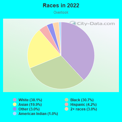
- 3,76138.1%White
- 3,03030.7%Black
- 1,96519.9%Asian
- 4194.2%Hispanic or Latino
- 2963.0%Some other race
- 2933.0%Two or more races
- 961.0%American Indian
Distribution of median household income
![Distribution of median household income]()
- 1,118Less than $10,000
- 653$10,000 to $19,999
- 850$20,000 to $29,999
- 612$30,000 to $39,999
- 559$40,000 to $49,999
- 356$50,000 to $59,999
- 740$60,000 to $74,999
- 411$75,000 to $99,999
- 414$100,000 to $124,999
- 234$125,000 to $149,999
- 233$150,000 to $199,999
- 193$200,000 or more

Distribution of owner-occupied house/condo value
![Distribution of owner-occupied house/condo value]()
- 1,346Less than $50,000
- 3,183$50,000 to $99,999
- 410$100,000 to $149,999
- 321$150,000 to $199,999
- 147$200,000 to $249,999
- 93$250,000 to $299,999
- 117$300,000 to $399,999
- 259$400,000 to $499,999
- 128$500,000 to $749,999
- 82$750,000 to $999,999
- 39$1,000,000 or more

Distribution of rent paid by renters
![Distribution of rent paid by renters]()
- 862Less than $100
- 155$100 to $199
- 573$200 to $299
- 899$300 to $399
- 770$400 to $499
- 806$500 to $599
- 295$600 to $699
- 650$700 to $799
- 475$800 to $899
- 820$900 to $999
- 1,175$1,000 to $1,249
- 275$1,250 to $1,499
- 439$1,500 to $1,999
- 303$2,000 or more

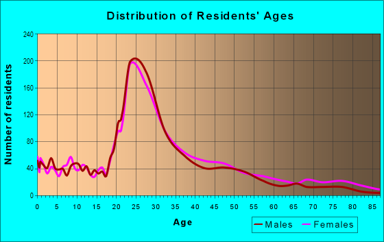
| Males: | 4,148 |
| Females: | 5,179 |
Males:
| This neighborhood: | 33.8 years |
| Whole city: | 35.6 years |
| This neighborhood: | 35.1 years |
| Whole city: | 38.1 years |
Average household size:
| Overlook: | 1.7 people |
| Cleveland: | 27.0 people |
Percentage of family households:
| Overlook: | 15.6% |
| Cleveland: | 32.3% |
| Here: | 11.2% |
| Cleveland: | 18.6% |
Percentage of married-couple families with children (among all households):
| Overlook: | 16.3% |
| Cleveland: | 10.0% |
Percentage of single-mother households (among all households):
| Overlook: | 54.2% |
| Cleveland: | 30.3% |
Percentage of never married males 15 years old and over:
Percentage of never married females 15 years old and over:
| Overlook: | 32.4% |
| Cleveland: | 27.7% |
Percentage of never married females 15 years old and over:
| Overlook: | 39.5% |
| city: | 26.3% |
Percentage of people that speak English not well or not at all:
| Overlook: | 0.8% |
| Cleveland: | 2.7% |
Percentage of people born in this state:
Percentage of people born in another U.S. state:
Percentage of native residents but born outside the U.S.:
Percentage of foreign born residents:
| Here: | 50.9% |
| Cleveland: | 71.5% |
Percentage of people born in another U.S. state:
| Overlook: | 30.0% |
| Cleveland: | 17.9% |
Percentage of native residents but born outside the U.S.:
| Here: | 0.9% |
| city: | 4.3% |
Percentage of foreign born residents:
| Here: | 18.3% |
| Cleveland: | 6.3% |
Owner-occupied
Renter-occupied

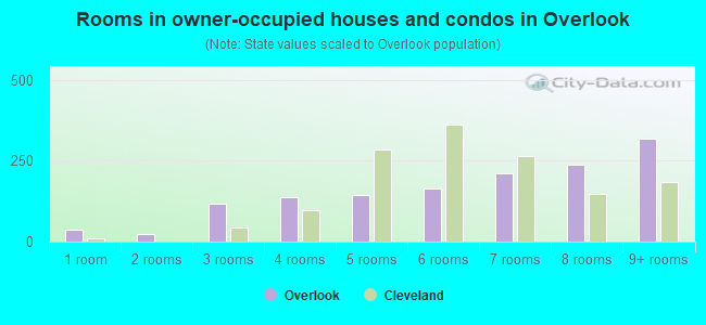
- Rooms in owner-occupied houses and condos in Overlook
- 371 room
- 242 rooms
- 1183 rooms
- 1394 rooms
- 1455 rooms
- 1636 rooms
- 2117 rooms
- 2388 rooms
- 3199+ rooms
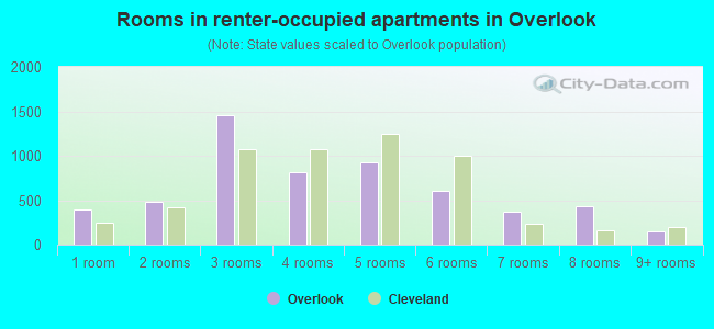
- Rooms in renter-occupied apartments in Overlook
- 4001 room
- 4862 rooms
- 1,4513 rooms
- 8104 rooms
- 9235 rooms
- 6106 rooms
- 3687 rooms
- 4358 rooms
- 1539+ rooms
Owner-occupied
Renter-occupied
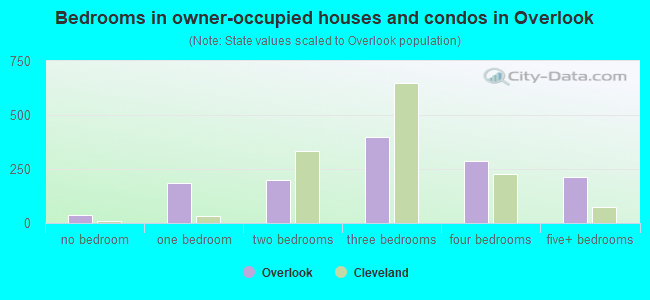
- Bedrooms in owner-occupied houses and condos in Overlook
- 37no bedroom
- 1851 bedroom
- 1972 bedrooms
- 3983 bedrooms
- 2884 bedrooms
- 2145+ bedrooms
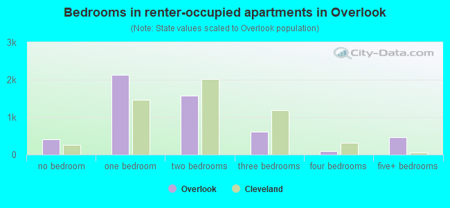
- Bedrooms in renter-occupied apartments in Overlook
- 401no bedroom
- 2,1321 bedroom
- 1,5802 bedrooms
- 6093 bedrooms
- 974 bedrooms
- 4705+ bedrooms
Average number of cars or other vehicles available in houses/condos:
Average number of cars or other vehicles available in apartments:
| This neighborhood: | |
| Cleveland: |
Average number of cars or other vehicles available in apartments:
| Here: | 0.8 |
| city: | 1.0 |
Percentage of units with a mortgage:
| Overlook: | 58.3% |
| Cleveland: | 50.7% |
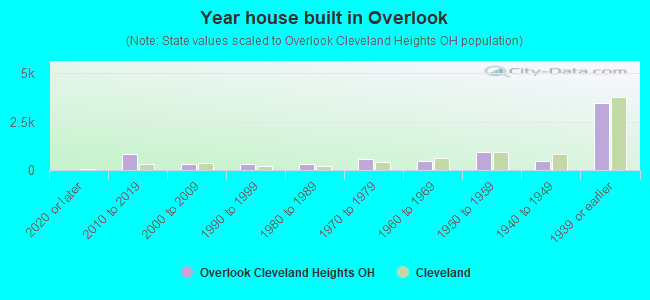
- Year house built in Overlook
- 02020 or later
- 8142010 to 2019
- 3112000 to 2009
- 3021990 to 1999
- 2971980 to 1989
- 5451970 to 1979
- 4901960 to 1969
- 9281950 to 1959
- 4441940 to 1949
- 3,4811939 or earlier
City-data.com crime index for city in 2020 (higher means more crime):
| City: | 735.3 |
| U.S. average: | 219.5 |
Travel time to work (commute)
![Travel time to work (commute)]()
- 139Less than 5 minutes
- 2505 to 9 minutes
- 71210 to 14 minutes
- 81415 to 19 minutes
- 50720 to 24 minutes
- 19025 to 29 minutes
- 47330 to 34 minutes
- 14735 to 39 minutes
- 10840 to 44 minutes
- 29745 to 59 minutes
- 15260 to 89 minutes
- 6290 or more minutes

Means of transportation to work
![Means of transportation to work]()
- 41.1%2,031Drove a car alone
- 7.5%370Carpooled
- 6.8%336Bus
- 1.8%88Subway or elevated rail
- 0.4%21Light rail, streetcar or trolley
- 16.2%799Bicycle
- 40.6%2,005Walked
- 4.4%218Other means
- 10.0%495Worked at home

Time leaving home to go to work
![Time leaving home to go to work]()
- 6312:00 a.m. to 4:59 a.m.
- 1865:00 a.m. to 5:29 a.m.
- 905:30 a.m. to 5:59 a.m.
- 2126:00 a.m. to 6:29 a.m.
- 2096:30 a.m. to 6:59 a.m.
- 1737:00 a.m. to 7:29 a.m.
- 3257:30 a.m. to 7:59 a.m.
- 3438:00 a.m. to 8:29 a.m.
- 4318:30 a.m. to 8:59 a.m.
- 6589:00 a.m. to 9:59 a.m.
- 23110:00 a.m. to 10:59 a.m.
- 5811:00 a.m. to 11:59 a.m.
- 44712:00 p.m. to 3:59 p.m.
- 2074:00 p.m. to 11:59 p.m.

Occupations of males:
- Percentage of males in management occupations (except farmers):
Here: 6.2% city: 7.3%
- Percentage of males in business and financial operations occupations:
Here: 8.9% city: 4.6%
- Percentage of males in computer and mathematical occupations:
Here: 6.1% city: 3.6%
- Percentage of males in architecture and engineering occupations:
Here: 8.3% city: 1.8%
- Percentage of males in life, physical, and social science occupations:
Here: 10.4% city: 1.2%
- Percentage of males in community and social services occupations:
Here: 1.4% city: 1.4%
- Percentage of males in education, training, and library occupations:
Here: 12.0% city: 2.1%
- Percentage of males in healthcare practitioners and technical occupations:
Here: 13.3% city: 3.5%
- Percentage of males in service occupations:
Here: 12.8% city: 20.2%
- Percentage of males in sales and office occupations:
Here: 12.9% city: 14.2%
- Percentage of males in transportation occupations:
Here: 1.8% city: 5.8%
- Percentage of males in material moving occupations:
Here: 3.8% city: 9.1%
Occupations of females:
- Percentage of females in management occupations (except farmers):
Here: 28.1% city: 6.9%
- Percentage of females in business and financial operations occupations:
Here: 7.6% city: 5.8%
- Percentage of females in computer and mathematical occupations:
Here: 1.2% city: 1.6%
- Percentage of females in life, physical, and social science occupations:
Here: 3.8% city: 1.1%
- Percentage of females in community and social services occupations:
Here: 3.3% city: 2.8%
- Percentage of females in education, training, and library occupations:
Here: 15.9% city: 5.8%
- Percentage of females in healthcare practitioners and technical occupations:
Here: 9.3% city: 9.3%
- Percentage of females in service occupations:
Here: 13.3% city: 26.3%
- Percentage of females in sales and office occupations:
Here: 11.7% city: 27.0%
- Percentage of females in production occupations:
Here: 3.1% city: 5.0%
Percentage of people 16-64 in Armed Forces:
| Overlook: | 0.1% |
| Cleveland: | 0.3% |
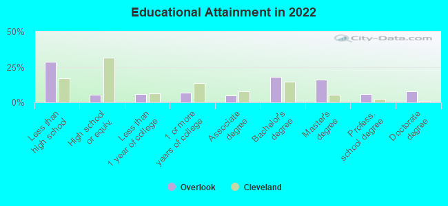
Education in this neighborhood (subdivision or community):
- Percentage of people 3 years and older in K-12 schools:
Overlook: 36.0% Cleveland: 15.5%
- Percentage of people 3 years and older in undergraduate colleges:
Overlook: 21.0% Cleveland: 5.1%
- Percentage of people 3 years and older in grad. or professional schools:
Overlook: 20.5% Cleveland: 1.7%
- Percentage of students K-12 enrolled in private schools:
Overlook: 62.5% Cleveland: 22.4%
Percentage of population below poverty level:
| Overlook: | 30.9% |
| Cleveland: | 31.8% |
Median year renter moved in (as recorded in 2022):
| Overlook: | 2017 |
| Cleveland: | 2019 |
Percentage of married-couple families with both working:
| Overlook: | 104.1% |
| Cleveland: | 72.0% |
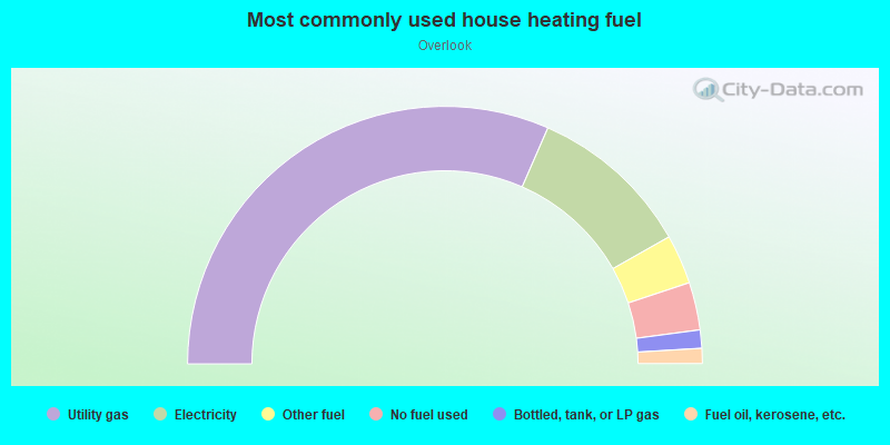
- 63.1%Utility gas
- 20.5%Electricity
- 6.2%Other fuel
- 6.0%No fuel used
- 2.3%Bottled, tank, or LP gas
- 1.9%Fuel oil, kerosene, etc.
Highways in this neighborhood:
Mayfield Rd (US Hwy 322)
Length: 2.24 miles
Directions: E-W, SW-NE
Address range: 2678 to 12699
Directions: E-W, SW-NE
Address range: 2678 to 12699
US Hwy 20 (Euclid Ave)
Length: 0.65 miles
Direction: SW-NE
Address range: 11531 to 12549
Direction: SW-NE
Address range: 11531 to 12549
Roads and streets:
Overlook Rd
Length: 1.14 miles
Directions: E-W, N-S, SE-NW, SW-NE
Address range: 2100 to 2599
Directions: E-W, N-S, SE-NW, SW-NE
Address range: 2100 to 2599
Edgehill Rd
Length: 0.97 miles
Directions: E-W, SE-NW, SW-NE
Address range: 2200 to 2609
Directions: E-W, SE-NW, SW-NE
Address range: 2200 to 2609
Derbyshire Rd
Length: 0.85 miles
Directions: E-W, N-S, SE-NW, SW-NE
Address range: 2400 to 2675
Directions: E-W, N-S, SE-NW, SW-NE
Address range: 2400 to 2675
Euclid Heights Blvd
Length: 0.81 miles
Directions: E-W, SW-NE
Address range: 2300 to 2622
Directions: E-W, SW-NE
Address range: 2300 to 2622
Kenilworth Rd
Length: 0.61 miles
Directions: E-W, N-S, SW-NE
Address range: 2300 to 2599
Directions: E-W, N-S, SW-NE
Address range: 2300 to 2599
E 123rd St
Length: 0.40 miles
Directions: N-S, SE-NW
Address range: 1800 to 1999
Directions: N-S, SE-NW
Address range: 1800 to 1999
Murray Hill Rd
Length: 0.38 miles
Directions: N-S, SW-NE
Address range: 2000 to 2181
Directions: N-S, SW-NE
Address range: 2000 to 2181
Norfolk Rd
Length: 0.38 miles
Directions: E-W, N-S, SW-NE
Address range: 2495 to 2699
Directions: E-W, N-S, SW-NE
Address range: 2495 to 2699
Berkshire Rd
Length: 0.37 miles
Directions: E-W, SE-NW
Address range: 2500 to 2649
Directions: E-W, SE-NW
Address range: 2500 to 2649
Coventry Rd
Length: 0.36 miles
Directions: N-S, SE-NW
Address range: 1536 to 1752
Directions: N-S, SE-NW
Address range: 1536 to 1752
Coltman Rd
Length: 0.34 miles
Directions: N-S, SE-NW
Address range: 1800 to 1999
Directions: N-S, SE-NW
Address range: 1800 to 1999
Avondale Ave
Length: 0.33 miles
Direction: E-W
Address range: 2781 to 2908
Direction: E-W
Address range: 2781 to 2908
Random Rd
Length: 0.33 miles
Directions: N-S, SW-NE
Address range: 2000 to 2159
Directions: N-S, SW-NE
Address range: 2000 to 2159
Cornell Rd
Length: 0.29 miles
Direction: SE-NW
Address range: 2065 to 2299
Direction: SE-NW
Address range: 2065 to 2299
Woodlawn Ave
Length: 0.28 miles
Direction: SE-NW
Address range: 1800 to 1999
Direction: SE-NW
Address range: 1800 to 1999
E 119th St
Length: 0.28 miles
Directions: N-S, SW-NE
Address range: 1800 to 1999
Directions: N-S, SW-NE
Address range: 1800 to 1999
Lakeview Rd
Length: 0.27 miles
Direction: SE-NW
Address range: 1600 to 1899
Direction: SE-NW
Address range: 1600 to 1899
Overlook Ln
Length: 0.27 miles
Direction: N-S
Address range: 2000 to 2199
Direction: N-S
Address range: 2000 to 2199
Hillcrest Rd
Length: 0.26 miles
Directions: N-S, SE-NW, SW-NE
Address range: 1500 to 1699
Directions: N-S, SE-NW, SW-NE
Address range: 1500 to 1699
Glenmont Rd
Length: 0.26 miles
Directions: N-S, SE-NW
Address range: 1600 to 1732
Directions: N-S, SE-NW
Address range: 1600 to 1732
Superior Rd
Length: 0.26 miles
Direction: SE-NW
Address range: 14146 to 14216
Direction: SE-NW
Address range: 14146 to 14216
Fairview Ave
Length: 0.24 miles
Directions: E-W, SE-NW, SW-NE
Address range: 2018 to 2149
Directions: E-W, SE-NW, SW-NE
Address range: 2018 to 2149
E 120th St
Length: 0.23 miles
Direction: N-S
Address range: 1882 to 1999
Direction: N-S
Address range: 1882 to 1999
Belmar Rd
Length: 0.22 miles
Directions: N-S, SE-NW
Address range: 1612 to 1719
Directions: N-S, SE-NW
Address range: 1612 to 1719
E 117th St
Length: 0.22 miles
Directions: N-S, SE-NW
Address range: 1900 to 1973
Directions: N-S, SE-NW
Address range: 1900 to 1973
E Overlook Rd
Length: 0.21 miles
Directions: E-W, N-S, SE-NW
Address range: 2601 to 2655
Directions: E-W, N-S, SE-NW
Address range: 2601 to 2655
Circle Dr
Length: 0.20 miles
Directions: N-S, SW-NE
Address range: 2000 to 2299
Directions: N-S, SW-NE
Address range: 2000 to 2299
Eddington Rd
Length: 0.19 miles
Directions: N-S, SE-NW
Address range: 1612 to 1699
Directions: N-S, SE-NW
Address range: 1612 to 1699
E 115th St
Length: 0.16 miles
Directions: N-S, SW-NE
Address range: 2000 to 2077
Directions: N-S, SW-NE
Address range: 2000 to 2077
Forest Hill Ave
Length: 0.15 miles
Direction: SW-NE
Address range: 12400 to 12699
Direction: SW-NE
Address range: 12400 to 12699
Edwards Rd
Length: 0.15 miles
Direction: E-W
Address range: 2300 to 2399
Direction: E-W
Address range: 2300 to 2399
E 124th Pl
Length: 0.13 miles
Direction: N-S
Address range: 1900 to 1999
Direction: N-S
Address range: 1900 to 1999
Fairview Ct
Length: 0.12 miles
Direction: E-W
Address range: 12200 to 12499
Direction: E-W
Address range: 12200 to 12499
Kenilworth Ln
Length: 0.12 miles
Directions: E-W, SE-NW
Address range: 2100 to 2499
Directions: E-W, SE-NW
Address range: 2100 to 2499
Kent Rd
Length: 0.12 miles
Direction: SE-NW
Address range: 2000 to 2099
Direction: SE-NW
Address range: 2000 to 2099
Mont Ave
Length: 0.12 miles
Directions: E-W, SW-NE
Address range: 13900 to 14099
Directions: E-W, SW-NE
Address range: 13900 to 14099
Berkshire Ln
Length: 0.11 miles
Direction: SE-NW
Address range: 2400 to 2499
Direction: SE-NW
Address range: 2400 to 2499
Paul Ave
Length: 0.10 miles
Direction: SE-NW
Address range: 12000 to 12099
Direction: SE-NW
Address range: 12000 to 12099
E 126th St
Length: 0.09 miles
Directions: N-S, SW-NE
Address range: 1900 to 1999
Directions: N-S, SW-NE
Address range: 1900 to 1999
Wade Park Ave
Length: 0.09 miles
Directions: E-W, SW-NE
Address range: 12110 to 12299
Directions: E-W, SW-NE
Address range: 12110 to 12299
Alexander Ave
Length: 0.07 miles
Direction: E-W
Address range: 12201 to 12399
Direction: E-W
Address range: 12201 to 12399
Ridgefield Rd
Length: 0.07 miles
Directions: N-S, SE-NW, SW-NE
Address range: 1580 to 1669
Directions: N-S, SE-NW, SW-NE
Address range: 1580 to 1669
Cedar Glen Pkwy
Length: 0.07 miles
Directions: E-W, SW-NE
Address range: 12000 to 12324
Directions: E-W, SW-NE
Address range: 12000 to 12324
Penrose Ave
Length: 0.06 miles
Direction: SE-NW
Address range: 1900 to 1999
Direction: SE-NW
Address range: 1900 to 1999
Cornell Cir
Length: 0.06 miles
Direction: SW-NE
Address range: 11600 to 11699
Direction: SW-NE
Address range: 11600 to 11699
Herrick Mews
Length: 0.06 miles
Directions: E-W, N-S, SE-NW
Address range: 1 to 99
Directions: E-W, N-S, SE-NW
Address range: 1 to 99
E 125th St
Length: 0.05 miles
Direction: N-S
Address range: 2000 to 2076
Direction: N-S
Address range: 2000 to 2076
Surrey Rd
Length: 0.04 miles
Direction: SE-NW
Address range: 2000 to 2125
Direction: SE-NW
Address range: 2000 to 2125
Prior Ct
Length: 0.03 miles
Direction: SW-NE
Address range: 2100 to 2151
Direction: SW-NE
Address range: 2100 to 2151
Railroad features:
Norfolk and Western Rlwy
Length: 1.84 miles
Directions: N-S, SW-NE
Directions: N-S, SW-NE