Upper Irvington neighborhood in Irvington, New Jersey (NJ), 07111 detailed profile
Settings
X

Business Search - 14 Million verified businesses
Area: 1.531 square miles
Population: 32,971
Population density:
| Upper Irvington: | 21,531 people per square mile |
| Irvington: | 20,528 people per square mile |

- 26,15063.8%Black
- 5,37013.1%Hispanic or Latino
- 3,4668.5%Some other race
- 1,8594.5%White
- 1,8414.5%Two or more races
- 1,3133.2%American Indian
- 1,0142.5%Asian

Distribution of median household income
![Distribution of median household income]()
- 1,900Less than $10,000
- 2,888$10,000 to $19,999
- 2,199$20,000 to $29,999
- 2,313$30,000 to $39,999
- 2,707$40,000 to $49,999
- 1,464$50,000 to $59,999
- 1,787$60,000 to $74,999
- 1,682$75,000 to $99,999
- 1,861$100,000 to $124,999
- 1,080$125,000 to $149,999
- 788$150,000 to $199,999
- 694$200,000 or more

Distribution of owner-occupied house/condo value
![Distribution of owner-occupied house/condo value]()
- 4,601Less than $50,000
- 1,988$50,000 to $99,999
- 902$100,000 to $149,999
- 1,360$150,000 to $199,999
- 726$200,000 to $249,999
- 1,141$250,000 to $299,999
- 1,136$300,000 to $399,999
- 1,604$400,000 to $499,999
- 618$500,000 to $749,999
- 302$750,000 to $999,999
- 1,807$1,000,000 or more

Distribution of rent paid by renters
![Distribution of rent paid by renters]()
- 3,128$100 to $199
- 5,431$200 to $299
- 1,378$300 to $399
- 1,432$400 to $499
- 2,502$500 to $599
- 1,480$600 to $699
- 2,123$700 to $799
- 1,395$800 to $899
- 1,187$900 to $999
- 4,167$1,000 to $1,249
- 1,989$1,250 to $1,499
- 1,159$1,500 to $1,999
- 3,112$2,000 or more

| Males: | 16,242 |
| Females: | 16,728 |
| Males: | 36.2 years |
| Females: | 39.2 years |
Average household size:
| Upper Irvington: | 6.4 people |
| New Jersey: | 2.6 people |
Percentage of family households:
| Upper Irvington: | 41.0% |
| New Jersey: | 47.0% |
| Here: | 24.7% |
| New Jersey: | 49.9% |
Percentage of married-couple families with children (among all households):
| Upper Irvington: | 20.1% |
| New Jersey: | 51.5% |
Percentage of single-mother households (among all households):
| Upper Irvington: | 22.2% |
| New Jersey: | 7.6% |
Percentage of never married males 15 years old and over:
Percentage of never married females 15 years old and over:
| Upper Irvington: | 28.7% |
| New Jersey: | 18.2% |
Percentage of never married females 15 years old and over:
| Upper Irvington: | 25.8% |
| New Jersey: | 16.6% |
Percentage of people that speak English not well or not at all:
| Upper Irvington: | 8.8% |
| New Jersey: | 6.5% |
Percentage of people born in this state:
Percentage of people born in another U.S. state:
Percentage of native residents but born outside the U.S.:
Percentage of foreign born residents:
| Here: | 46.0% |
| New Jersey: | 50.7% |
Percentage of people born in another U.S. state:
| Upper Irvington: | 16.0% |
| New Jersey: | 23.4% |
Percentage of native residents but born outside the U.S.:
| Here: | 2.4% |
| New Jersey: | 2.4% |
Percentage of foreign born residents:
| Here: | 35.9% |
| New Jersey: | 23.5% |
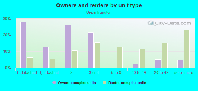
Owner-occupied
Renter-occupied

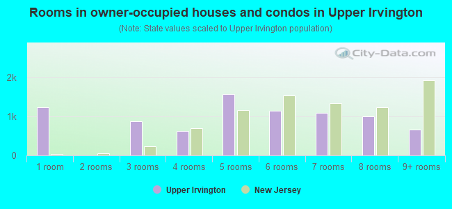
- Rooms in owner-occupied houses and condos in Upper Irvington
- 1,2371 room
- 02 rooms
- 8703 rooms
- 6264 rooms
- 1,5655 rooms
- 1,1496 rooms
- 1,0947 rooms
- 1,0008 rooms
- 6649+ rooms
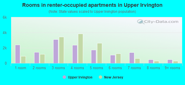
- Rooms in renter-occupied apartments in Upper Irvington
- 2,4161 room
- 1,4402 rooms
- 3,0973 rooms
- 2,3594 rooms
- 1,7475 rooms
- 1,0766 rooms
- 1,4077 rooms
- 4958 rooms
- 4869+ rooms
Owner-occupied
Renter-occupied
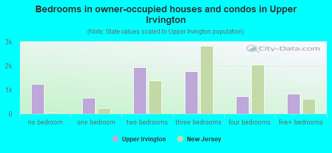
- Bedrooms in owner-occupied houses and condos in Upper Irvington
- 1,237no bedroom
- 6551 bedroom
- 1,9312 bedrooms
- 1,7633 bedrooms
- 7334 bedrooms
- 8235+ bedrooms
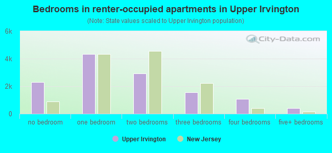
- Bedrooms in renter-occupied apartments in Upper Irvington
- 2,291no bedroom
- 4,3171 bedroom
- 2,9082 bedrooms
- 1,5453 bedrooms
- 1,0764 bedrooms
- 4215+ bedrooms
Average number of cars or other vehicles available in houses/condos:
Average number of cars or other vehicles available in apartments:
| This neighborhood: | 2.1 |
| New Jersey: | 2.0 |
Average number of cars or other vehicles available in apartments:
| Here: | 0.8 |
| New Jersey: | 1.1 |
Percentage of units with a mortgage:
| Upper Irvington: | 72.9% |
| New Jersey: | 63.3% |
Average estimated value of detached houses in 2022 (18.6% of all units):
| Upper Irvington: | $389,562 |
| New Jersey: | $537,591 |
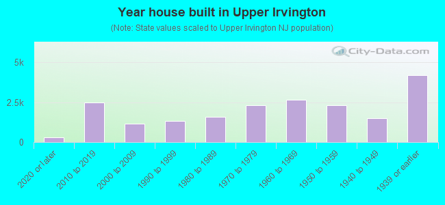
- Year house built in Upper Irvington
- 3172020 or later
- 2,4982010 to 2019
- 1,1772000 to 2009
- 1,3131990 to 1999
- 1,5671980 to 1989
- 2,3101970 to 1979
- 2,6711960 to 1969
- 2,3061950 to 1959
- 1,4821940 to 1949
- 4,2051939 or earlier
City-data.com crime index for place in 2020 (higher means more crime):
| City: | 267.7 |
| U.S. average: | 219.5 |
Travel time to work (commute)
![Travel time to work (commute)]()
- 220Less than 5 minutes
- 9715 to 9 minutes
- 1,04710 to 14 minutes
- 1,71715 to 19 minutes
- 2,44420 to 24 minutes
- 1,01925 to 29 minutes
- 2,62830 to 34 minutes
- 64135 to 39 minutes
- 66940 to 44 minutes
- 1,75045 to 59 minutes
- 1,04160 to 89 minutes
- 1,10390 or more minutes

Means of transportation to work
![Means of transportation to work]()
- 63.2%9,871Drove a car alone
- 10.8%1,689Carpooled
- 14.8%2,316Bus
- 9.2%1,441Subway or elevated rail
- 9.6%1,502Long-distance train or commuter rail
- 6.5%1,019Taxi
- 5.7%885Bicycle
- 10.5%1,640Walked
- 4.5%709Other means
- 8.8%1,369Worked at home

Time leaving home to go to work
![Time leaving home to go to work]()
- 1,01012:00 a.m. to 4:59 a.m.
- 5385:00 a.m. to 5:29 a.m.
- 6675:30 a.m. to 5:59 a.m.
- 1,7926:00 a.m. to 6:29 a.m.
- 1,0096:30 a.m. to 6:59 a.m.
- 1,6007:00 a.m. to 7:29 a.m.
- 9477:30 a.m. to 7:59 a.m.
- 1,4148:00 a.m. to 8:29 a.m.
- 1,0298:30 a.m. to 8:59 a.m.
- 7049:00 a.m. to 9:59 a.m.
- 61310:00 a.m. to 10:59 a.m.
- 97211:00 a.m. to 11:59 a.m.
- 1,78512:00 p.m. to 3:59 p.m.
- 1,3554:00 p.m. to 11:59 p.m.

Occupations of males:
- Percentage of males in management occupations (except farmers):
Here: 4.0% New Jersey: 13.9%
- Percentage of males in business and financial operations occupations:
Here: 2.2% New Jersey: 6.9%
- Percentage of males in computer and mathematical occupations:
Here: 1.2% New Jersey: 6.5%
- Percentage of males in architecture and engineering occupations:
Here: 1.1% New Jersey: 3.1%
- Percentage of males in life, physical, and social science occupations:
Here: 1.3% New Jersey: 1.2%
- Percentage of males in community and social services occupations:
Here: 1.9% New Jersey: 1.1%
- Percentage of males in education, training, and library occupations:
Here: 2.1% New Jersey: 3.6%
- Percentage of males in healthcare practitioners and technical occupations:
Here: 2.8% New Jersey: 3.2%
- Percentage of males in service occupations:
Here: 16.5% New Jersey: 12.9%
- Percentage of males in sales and office occupations:
Here: 15.4% New Jersey: 15.3%
- Percentage of males in construction, extraction, and maintenance occupations:
Here: 9.9% New Jersey: 8.1%
- Percentage of males in production occupations:
Here: 8.2% New Jersey: 4.8%
- Percentage of males in transportation occupations:
Here: 11.7% New Jersey: 6.5%
- Percentage of males in material moving occupations:
Here: 16.0% New Jersey: 4.7%
Occupations of females:
- Percentage of females in management occupations (except farmers):
Here: 4.7% New Jersey: 10.4%
- Percentage of females in business and financial operations occupations:
Here: 5.4% New Jersey: 7.3%
- Percentage of females in community and social services occupations:
Here: 3.3% New Jersey: 2.6%
- Percentage of females in education, training, and library occupations:
Here: 9.2% New Jersey: 11.4%
- Percentage of females in healthcare practitioners and technical occupations:
Here: 6.5% New Jersey: 9.6%
- Percentage of females in service occupations:
Here: 27.5% New Jersey: 17.2%
- Percentage of females in sales and office occupations:
Here: 34.7% New Jersey: 26.7%
- Percentage of females in production occupations:
Here: 2.8% New Jersey: 2.7%
- Percentage of females in transportation occupations:
Here: 1.5% New Jersey: 1.2%
- Percentage of females in material moving occupations:
Here: 3.0% New Jersey: 2.4%
Percentage of people 16-64 in Armed Forces:
| Upper Irvington: | 0.1% |
| New Jersey: | 0.2% |
Education in this neighborhood (subdivision or community):
- Percentage of people 3 years and older in K-12 schools:
Upper Irvington: 33.6% New Jersey: 16.6%
- Percentage of people 3 years and older in undergraduate colleges:
Upper Irvington: 8.0% New Jersey: 4.9%
- Percentage of people 3 years and older in grad. or professional schools:
Upper Irvington: 6.1% New Jersey: 1.6%
- Percentage of students K-12 enrolled in private schools:
Upper Irvington: 56.3% New Jersey: 12.7%
Percentage of population below poverty level:
| Upper Irvington: | 20.0% |
| New Jersey: | 9.7% |
Percentage of married-couple families with both working:
| Upper Irvington: | 131.8% |
| New Jersey: | 72.0% |
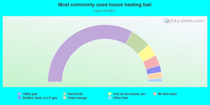
- 65.8%Utility gas
- 11.8%Electricity
- 7.0%Fuel oil, kerosene, etc.
- 6.0%No fuel used
- 3.9%Bottled, tank, or LP gas
- 3.6%Solar energy
- 1.9%Other fuel
Limited-access highways (interstate or state) in this neighborhood:
Garden State Pkwy
Length: 1.47 miles
Directions: E-W, SW-NE
Directions: E-W, SW-NE
Highways in this neighborhood:
State Rte 124 (Springfield Ave)
Length: 1.72 miles
Direction: E-W
Address range: 844 to 1353
Direction: E-W
Address range: 844 to 1353
Roads and streets:
Union Ave
Length: 1.44 miles
Directions: E-W, SW-NE
Address range: 3 to 599
Directions: E-W, SW-NE
Address range: 3 to 599
Chancellor Ave
Length: 1.40 miles
Directions: E-W, SE-NW
Address range: 542 to 960
Directions: E-W, SE-NW
Address range: 542 to 960
Stuyvesant Ave
Length: 1.30 miles
Directions: N-S, SW-NE
Address range: 373 to 873
Directions: N-S, SW-NE
Address range: 373 to 873
Clinton Ave
Length: 1.26 miles
Directions: E-W, SE-NW, SW-NE
Address range: 990 to 1388
Directions: E-W, SE-NW, SW-NE
Address range: 990 to 1388
Rte 509 (Grove St)
Length: 1.05 miles
Directions: E-W, N-S, SW-NE
Address range: 848 to 1232
Directions: E-W, N-S, SW-NE
Address range: 848 to 1232
Lyons Ave
Length: 1.00 miles
Directions: E-W, SE-NW
Address range: 573 to 899
Directions: E-W, SE-NW
Address range: 573 to 899
Nye Ave
Length: 0.98 miles
Directions: E-W, SE-NW
Address range: 426 to 740
Directions: E-W, SE-NW
Address range: 426 to 740
Madison Ave
Length: 0.83 miles
Directions: E-W, SE-NW
Address range: 14 to 316
Directions: E-W, SE-NW
Address range: 14 to 316
Lincoln Pl
Length: 0.82 miles
Directions: N-S, SW-NE
Address range: 3 to 299
Directions: N-S, SW-NE
Address range: 3 to 299
Park Pl
Length: 0.78 miles
Directions: N-S, SW-NE
Address range: 1 to 260
Directions: N-S, SW-NE
Address range: 1 to 260
Sanford Ave
Length: 0.76 miles
Directions: N-S, SW-NE
Address range: 804 to 1110
Directions: N-S, SW-NE
Address range: 804 to 1110
Chestnut Ave
Length: 0.72 miles
Directions: N-S, SE-NW
Address range: 3 to 1499
Directions: N-S, SE-NW
Address range: 3 to 1499
Nesbit Ter
Length: 0.70 miles
Direction: SW-NE
Address range: 1 to 230
Direction: SW-NE
Address range: 1 to 230
Berkshire Pl
Length: 0.62 miles
Directions: E-W, SE-NW
Address range: 1 to 199
Directions: E-W, SE-NW
Address range: 1 to 199
Paine Ave
Length: 0.59 miles
Direction: SE-NW
Address range: 1 to 199
Direction: SE-NW
Address range: 1 to 199
Maple Ave
Length: 0.59 miles
Directions: SE-NW, SW-NE
Address range: 3 to 231
Directions: SE-NW, SW-NE
Address range: 3 to 231
Coit St (Rte 509)
Length: 0.56 miles
Directions: N-S, SE-NW, SW-NE
Address range: 248 to 471
Directions: N-S, SE-NW, SW-NE
Address range: 248 to 471
Augusta St
Length: 0.49 miles
Direction: SW-NE
Address range: 1 to 199
Direction: SW-NE
Address range: 1 to 199
Orange Ave
Length: 0.48 miles
Directions: N-S, SW-NE
Address range: 1 to 187
Directions: N-S, SW-NE
Address range: 1 to 187
Ball St
Length: 0.48 miles
Direction: SW-NE
Address range: 3 to 163
Direction: SW-NE
Address range: 3 to 163
Hillside Ter
Length: 0.47 miles
Direction: SW-NE
Address range: 53 to 241
Direction: SW-NE
Address range: 53 to 241
Yale Ave
Length: 0.43 miles
Directions: E-W, SE-NW
Address range: 1 to 146
Directions: E-W, SE-NW
Address range: 1 to 146
Cleremont Ave
Length: 0.42 miles
Directions: E-W, SW-NE
Address range: 3 to 131
Directions: E-W, SW-NE
Address range: 3 to 131
Welland Ave
Length: 0.41 miles
Direction: SE-NW
Address range: 1 to 134
Direction: SE-NW
Address range: 1 to 134
Prospect Ave
Length: 0.41 miles
Direction: SE-NW
Address range: 1 to 118
Direction: SE-NW
Address range: 1 to 118
Melville Pl
Length: 0.40 miles
Directions: E-W, SE-NW
Address range: 1 to 128
Directions: E-W, SE-NW
Address range: 1 to 128
Rosehill Pl
Length: 0.39 miles
Direction: E-W
Address range: 1 to 133
Direction: E-W
Address range: 1 to 133
Webster St
Length: 0.37 miles
Direction: SE-NW
Address range: 1 to 139
Direction: SE-NW
Address range: 1 to 139
Washington Ave
Length: 0.37 miles
Directions: E-W, N-S, SE-NW, SW-NE
Address range: 1 to 128
Directions: E-W, N-S, SE-NW, SW-NE
Address range: 1 to 128
Mount Vernon Ave
Length: 0.37 miles
Directions: N-S, SE-NW
Address range: 1 to 132
Directions: N-S, SE-NW
Address range: 1 to 132
38th St
Length: 0.36 miles
Directions: N-S, SW-NE
Address range: 3 to 144
Directions: N-S, SW-NE
Address range: 3 to 144
Linden Ave
Length: 0.35 miles
Direction: SW-NE
Address range: 1 to 130
Direction: SW-NE
Address range: 1 to 130
May St
Length: 0.34 miles
Direction: SE-NW
Address range: 1 to 122
Direction: SE-NW
Address range: 1 to 122
Chapman Pl
Length: 0.34 miles
Directions: N-S, SW-NE
Address range: 1 to 123
Directions: N-S, SW-NE
Address range: 1 to 123
Myrtle Ave
Length: 0.33 miles
Directions: N-S, SW-NE
Address range: 1 to 129
Directions: N-S, SW-NE
Address range: 1 to 129
Cummings St
Length: 0.33 miles
Direction: SW-NE
Address range: 1 to 138
Direction: SW-NE
Address range: 1 to 138
Grace St
Length: 0.33 miles
Direction: SW-NE
Address range: 1 to 130
Direction: SW-NE
Address range: 1 to 130
Howard St
Length: 0.32 miles
Direction: SW-NE
Address range: 1 to 126
Direction: SW-NE
Address range: 1 to 126
Chester Ave
Length: 0.30 miles
Direction: SW-NE
Address range: 3 to 99
Direction: SW-NE
Address range: 3 to 99
Wilson Pl
Length: 0.30 miles
Direction: SW-NE
Address range: 3 to 126
Direction: SW-NE
Address range: 3 to 126
Laventhal Ave
Length: 0.30 miles
Direction: SE-NW
Address range: 1 to 99
Direction: SE-NW
Address range: 1 to 99
Laurel Ave
Length: 0.29 miles
Direction: E-W
Address range: 1 to 98
Direction: E-W
Address range: 1 to 98
40th St
Length: 0.29 miles
Directions: N-S, SW-NE
Address range: 3 to 108
Directions: N-S, SW-NE
Address range: 3 to 108
Wagner Pl
Length: 0.29 miles
Direction: SE-NW
Address range: 1 to 99
Direction: SE-NW
Address range: 1 to 99
Brookside Ave
Length: 0.29 miles
Directions: N-S, SW-NE
Address range: 1 to 105
Directions: N-S, SW-NE
Address range: 1 to 105
Smith St
Length: 0.28 miles
Direction: N-S
Address range: 1 to 116
Direction: N-S
Address range: 1 to 116
Sheridan St
Length: 0.28 miles
Direction: SW-NE
Address range: 1 to 99
Direction: SW-NE
Address range: 1 to 99
Rutgers St
Length: 0.28 miles
Directions: N-S, SE-NW, SW-NE
Address range: 1 to 99
Directions: N-S, SE-NW, SW-NE
Address range: 1 to 99
Grant Pl
Length: 0.28 miles
Direction: N-S
Address range: 3 to 116
Direction: N-S
Address range: 3 to 116
Kuna Ter
Length: 0.28 miles
Direction: SW-NE
Address range: 1 to 99
Direction: SW-NE
Address range: 1 to 99
Norwood Ave
Length: 0.28 miles
Directions: N-S, SW-NE
Address range: 1 to 99
Directions: N-S, SW-NE
Address range: 1 to 99
Osborne Pl
Length: 0.27 miles
Direction: SW-NE
Address range: 1 to 99
Direction: SW-NE
Address range: 1 to 99
Durand Pl
Length: 0.27 miles
Directions: N-S, SW-NE
Address range: 3 to 99
Directions: N-S, SW-NE
Address range: 3 to 99
Bross Pl
Length: 0.27 miles
Directions: E-W, SE-NW
Address range: 1 to 99
Directions: E-W, SE-NW
Address range: 1 to 99
Sherman Pl
Length: 0.27 miles
Directions: N-S, SW-NE
Address range: 3 to 99
Directions: N-S, SW-NE
Address range: 3 to 99
Campfield St
Length: 0.27 miles
Directions: N-S, SE-NW
Address range: 1 to 99
Directions: N-S, SE-NW
Address range: 1 to 99
Chapman St
Length: 0.27 miles
Direction: SW-NE
Address range: 360 to 468
Direction: SW-NE
Address range: 360 to 468
Elmwood Ave
Length: 0.26 miles
Direction: E-W
Address range: 1 to 86
Direction: E-W
Address range: 1 to 86
Fern Ave
Length: 0.26 miles
Direction: SE-NW
Address range: 1 to 99
Direction: SE-NW
Address range: 1 to 99
Bedford Ter
Length: 0.24 miles
Directions: E-W, SW-NE
Address range: 1 to 99
Directions: E-W, SW-NE
Address range: 1 to 99
Naden Ave
Length: 0.24 miles
Direction: SE-NW
Address range: 1 to 83
Direction: SE-NW
Address range: 1 to 83
Eastern Pkwy
Length: 0.24 miles
Directions: E-W, N-S, SE-NW, SW-NE
Directions: E-W, N-S, SE-NW, SW-NE
Marshall St
Length: 0.23 miles
Directions: E-W, N-S, SE-NW, SW-NE
Address range: 1 to 74
Directions: E-W, N-S, SE-NW, SW-NE
Address range: 1 to 74
Mountainview Pl
Length: 0.22 miles
Direction: E-W
Address range: 1 to 62
Direction: E-W
Address range: 1 to 62
Quabeck Ave
Length: 0.22 miles
Direction: SE-NW
Address range: 23 to 99
Direction: SE-NW
Address range: 23 to 99
Philip Pl
Length: 0.21 miles
Direction: SW-NE
Address range: 1 to 99
Direction: SW-NE
Address range: 1 to 99
Civic Sq
Length: 0.21 miles
Directions: N-S, SW-NE
Directions: N-S, SW-NE
Temple Pl
Length: 0.21 miles
Direction: SW-NE
Address range: 1 to 67
Direction: SW-NE
Address range: 1 to 67
Bruen Ave
Length: 0.20 miles
Direction: SW-NE
Address range: 1 to 83
Direction: SW-NE
Address range: 1 to 83
Oakland St
Length: 0.19 miles
Direction: E-W
Address range: 1 to 68
Direction: E-W
Address range: 1 to 68
New St
Length: 0.18 miles
Directions: N-S, SW-NE
Address range: 1 to 69
Directions: N-S, SW-NE
Address range: 1 to 69
Rich St
Length: 0.18 miles
Direction: E-W
Address range: 1 to 57
Direction: E-W
Address range: 1 to 57
39th St
Length: 0.18 miles
Direction: SW-NE
Address range: 1 to 75
Direction: SW-NE
Address range: 1 to 75
Dupont Pl
Length: 0.18 miles
Directions: E-W, SW-NE
Address range: 1 to 59
Directions: E-W, SW-NE
Address range: 1 to 59
S Durand Pl
Length: 0.17 miles
Direction: SW-NE
Address range: 95 to 162
Direction: SW-NE
Address range: 95 to 162
Newton Pl
Length: 0.17 miles
Directions: N-S, SW-NE
Address range: 1 to 75
Directions: N-S, SW-NE
Address range: 1 to 75
Normandy Pl
Length: 0.17 miles
Direction: SW-NE
Address range: 3 to 56
Direction: SW-NE
Address range: 3 to 56
Orange Pl
Length: 0.16 miles
Direction: E-W
Address range: 1 to 58
Direction: E-W
Address range: 1 to 58
Essex St
Length: 0.16 miles
Direction: SW-NE
Address range: 1 to 62
Direction: SW-NE
Address range: 1 to 62
Sharon Ave
Length: 0.16 miles
Directions: E-W, SW-NE
Address range: 1 to 62
Directions: E-W, SW-NE
Address range: 1 to 62
Crescent Ln
Length: 0.15 miles
Directions: E-W, N-S, SE-NW, SW-NE
Address range: 2 to 14
Directions: E-W, N-S, SE-NW, SW-NE
Address range: 2 to 14
Civic Sq W
Length: 0.15 miles
Direction: N-S
Address range: 1 to 66
Direction: N-S
Address range: 1 to 66
Tremont St
Length: 0.15 miles
Direction: E-W
Address range: 1 to 48
Direction: E-W
Address range: 1 to 48
N Maple Ave
Length: 0.15 miles
Direction: SE-NW
Address range: 1 to 32
Direction: SE-NW
Address range: 1 to 32
Hoffman Pl
Length: 0.14 miles
Direction: SW-NE
Address range: 1 to 54
Direction: SW-NE
Address range: 1 to 54
Wolf Pl
Length: 0.14 miles
Direction: SW-NE
Address range: 1 to 46
Direction: SW-NE
Address range: 1 to 46
Greene Ter
Length: 0.14 miles
Direction: N-S
Address range: 3 to 486
Direction: N-S
Address range: 3 to 486
W Rich St
Length: 0.14 miles
Direction: E-W
Address range: 46 to 112
Direction: E-W
Address range: 46 to 112
Martin Pl
Length: 0.14 miles
Direction: N-S
Address range: 3 to 60
Direction: N-S
Address range: 3 to 60
Liberty St
Length: 0.13 miles
Direction: E-W
Address range: 1 to 32
Direction: E-W
Address range: 1 to 32
Lehigh Pl
Length: 0.13 miles
Directions: E-W, SE-NW, SW-NE
Address range: 1 to 46
Directions: E-W, SE-NW, SW-NE
Address range: 1 to 46
Momm Ct
Length: 0.12 miles
Direction: E-W
Address range: 1 to 31
Direction: E-W
Address range: 1 to 31
Beaumont Pl
Length: 0.11 miles
Direction: E-W
Address range: 1 to 42
Direction: E-W
Address range: 1 to 42
Elm Pl
Length: 0.11 miles
Direction: SE-NW
Address range: 1 to 53
Direction: SE-NW
Address range: 1 to 53
Maple Pl
Length: 0.10 miles
Direction: SE-NW
Address range: 1 to 40
Direction: SE-NW
Address range: 1 to 40
Medbourne Ave
Length: 0.10 miles
Direction: SW-NE
Address range: 1 to 44
Direction: SW-NE
Address range: 1 to 44
Stratford Pl
Length: 0.10 miles
Direction: SE-NW
Address range: 1 to 65
Direction: SE-NW
Address range: 1 to 65
Renee Pl
Length: 0.10 miles
Direction: E-W
Address range: 1 to 37
Direction: E-W
Address range: 1 to 37
Irvington Pl
Length: 0.10 miles
Direction: SE-NW
Address range: 1 to 39
Direction: SE-NW
Address range: 1 to 39
Sager Pl
Length: 0.10 miles
Direction: SW-NE
Address range: 1 to 65
Direction: SW-NE
Address range: 1 to 65
Denman Pl
Length: 0.10 miles
Directions: E-W, SE-NW
Address range: 1 to 54
Directions: E-W, SE-NW
Address range: 1 to 54
Robert Pl
Length: 0.10 miles
Direction: SE-NW
Address range: 1 to 40
Direction: SE-NW
Address range: 1 to 40
Hazel Pl
Length: 0.10 miles
Direction: SE-NW
Address range: 1 to 40
Direction: SE-NW
Address range: 1 to 40
Cottage Pl
Length: 0.09 miles
Direction: E-W
Address range: 1 to 28
Direction: E-W
Address range: 1 to 28
Lake St
Length: 0.09 miles
Direction: N-S
Address range: 1 to 46
Direction: N-S
Address range: 1 to 46
Lenox Ave
Length: 0.09 miles
Direction: SW-NE
Address range: 121 to 160
Direction: SW-NE
Address range: 121 to 160
Mill Rd
Length: 0.09 miles
Direction: E-W
Address range: 530 to 577
Direction: E-W
Address range: 530 to 577
McGotty Pl
Length: 0.08 miles
Direction: SE-NW
Address range: 1 to 36
Direction: SE-NW
Address range: 1 to 36
Edmund Pl
Length: 0.08 miles
Direction: SE-NW
Address range: 1 to 30
Direction: SE-NW
Address range: 1 to 30
Herpers St
Length: 0.08 miles
Direction: SE-NW
Address range: 1 to 26
Direction: SE-NW
Address range: 1 to 26
Ruth St
Length: 0.08 miles
Direction: SE-NW
Address range: 1 to 32
Direction: SE-NW
Address range: 1 to 32
Taft St
Length: 0.08 miles
Direction: SE-NW
Address range: 1 to 25
Direction: SE-NW
Address range: 1 to 25
Victor Pl
Length: 0.08 miles
Direction: N-S
Address range: 3 to 29
Direction: N-S
Address range: 3 to 29
Stanley St
Length: 0.07 miles
Direction: SE-NW
Address range: 1 to 40
Direction: SE-NW
Address range: 1 to 40
Weber Pl
Length: 0.07 miles
Direction: E-W
Address range: 1 to 30
Direction: E-W
Address range: 1 to 30
Cornell St
Length: 0.07 miles
Direction: SW-NE
Address range: 1 to 42
Direction: SW-NE
Address range: 1 to 42
Bell St
Length: 0.07 miles
Direction: SE-NW
Address range: 1 to 40
Direction: SE-NW
Address range: 1 to 40
Banta Pl
Length: 0.07 miles
Direction: E-W
Address range: 1 to 26
Direction: E-W
Address range: 1 to 26
Clements Pl
Length: 0.06 miles
Direction: E-W
Address range: 1 to 30
Direction: E-W
Address range: 1 to 30
Pine Pl
Length: 0.06 miles
Direction: SE-NW
Address range: 1 to 28
Direction: SE-NW
Address range: 1 to 28
Drakes Ln
Length: 0.06 miles
Direction: N-S
Address range: 1 to 1299
Direction: N-S
Address range: 1 to 1299
McAllister Pl
Length: 0.06 miles
Direction: SW-NE
Address range: 1 to 32
Direction: SW-NE
Address range: 1 to 32
Wyckoff Pl
Length: 0.06 miles
Direction: SW-NE
Direction: SW-NE
Fairchild Pl
Length: 0.05 miles
Direction: SW-NE
Address range: 1 to 35
Direction: SW-NE
Address range: 1 to 35
Oak Pl
Length: 0.04 miles
Direction: SE-NW
Address range: 1 to 27
Direction: SE-NW
Address range: 1 to 27
Ens Pl
Length: 0.03 miles
Direction: E-W
Address range: 1 to 17
Direction: E-W
Address range: 1 to 17
Rte 509
Length: 0.03 miles
Direction: SW-NE
Direction: SW-NE
Bryant Ct
Length: 0.03 miles
Direction: SE-NW
Address range: 1 to 29
Direction: SE-NW
Address range: 1 to 29
Other features:
Elizabeth Riv
Length: 1.17 miles
Directions: N-S, SW-NE
Directions: N-S, SW-NE
Roads and streets:
Mill Rd
Length: 0.03 miles
Direction: E-W
Direction: E-W
N Union Ave
Length: 0.00 miles
Directions: N-S, SE-NW
Directions: N-S, SE-NW