West Side neighborhood in Buffalo, New York (NY), 14201, 14213, 14222 detailed profile
Settings
X

Business Search - 14 Million verified businesses
Area: 2.899 square miles
Population: 46,058
Population density:
| West Side: | 15,890 people per square mile |
| Buffalo: | 6,808 people per square mile |

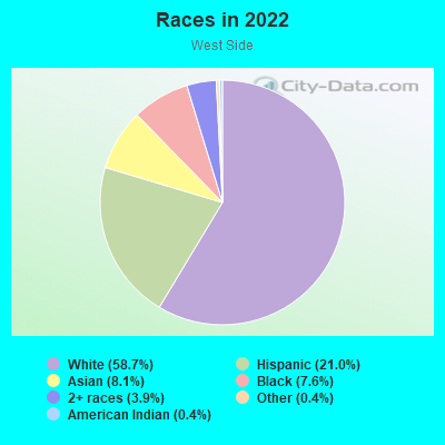
- 26,17851.0%White
- 8,65016.8%Hispanic or Latino
- 8,15315.9%Black
- 4,9769.7%Asian
- 1,8573.6%Two or more races
- 8131.6%American Indian
- 7381.4%Some other race
Median household income in 2022:
| West Side: | $63,162 |
| Buffalo: | $48,904 |
Distribution of median household income
![Distribution of median household income]()
- 2,269Less than $10,000
- 3,489$10,000 to $19,999
- 2,425$20,000 to $29,999
- 2,543$30,000 to $39,999
- 2,764$40,000 to $49,999
- 1,824$50,000 to $59,999
- 3,343$60,000 to $74,999
- 2,623$75,000 to $99,999
- 2,729$100,000 to $124,999
- 1,753$125,000 to $149,999
- 1,667$150,000 to $199,999
- 1,728$200,000 or more

Distribution of owner-occupied house/condo value
![Distribution of owner-occupied house/condo value]()
- 5,484Less than $50,000
- 5,893$50,000 to $99,999
- 1,635$100,000 to $149,999
- 1,824$150,000 to $199,999
- 2,052$200,000 to $249,999
- 1,905$250,000 to $299,999
- 1,420$300,000 to $399,999
- 1,671$400,000 to $499,999
- 1,252$500,000 to $749,999
- 433$750,000 to $999,999
- 1,796$1,000,000 or more

Distribution of rent paid by renters
![Distribution of rent paid by renters]()
- 347Less than $100
- 493$100 to $199
- 2,645$200 to $299
- 1,194$300 to $399
- 2,296$400 to $499
- 3,429$500 to $599
- 3,825$600 to $699
- 2,564$700 to $799
- 2,163$800 to $899
- 1,639$900 to $999
- 3,093$1,000 to $1,249
- 1,816$1,250 to $1,499
- 2,561$1,500 to $1,999
- 2,214$2,000 or more

Median rent in 2022:
| West Side: | $1,015 |
| Buffalo: | $797 |
| Males: | 23,571 |
| Females: | 22,486 |
Males:
| This neighborhood: | 32.0 years |
| Whole city: | 34.6 years |
| This neighborhood: | 35.3 years |
| Whole city: | 35.0 years |
Average household size:
| West Side: | 5.9 people |
| Buffalo: | 2.2 people |
Percentage of family households:
| West Side: | 36.1% |
| Buffalo: | 35.8% |
| Here: | 23.1% |
| Buffalo: | 24.5% |
Percentage of married-couple families with children (among all households):
| West Side: | 21.9% |
| Buffalo: | 22.3% |
Percentage of single-mother households (among all households):
| West Side: | 29.7% |
| Buffalo: | 17.8% |
Percentage of never married males 15 years old and over:
Percentage of never married females 15 years old and over:
| West Side: | 27.9% |
| Buffalo: | 25.6% |
Percentage of never married females 15 years old and over:
| West Side: | 28.0% |
| city: | 26.3% |
Percentage of people that speak English not well or not at all:
| West Side: | 4.8% |
| Buffalo: | 4.0% |
Percentage of people born in this state:
Percentage of people born in another U.S. state:
Percentage of native residents but born outside the U.S.:
Percentage of foreign born residents:
| Here: | 70.9% |
| Buffalo: | 75.1% |
Percentage of people born in another U.S. state:
| West Side: | 12.7% |
| Buffalo: | 10.9% |
Percentage of native residents but born outside the U.S.:
| Here: | 4.4% |
| city: | 3.9% |
Percentage of foreign born residents:
| Here: | 12.0% |
| Buffalo: | 10.0% |
Owner-occupied
Renter-occupied

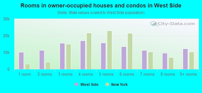
- Rooms in owner-occupied houses and condos in West Side
- 01 room
- 4152 rooms
- 9943 rooms
- 1,5994 rooms
- 1,1995 rooms
- 1,9646 rooms
- 1,5887 rooms
- 1,3568 rooms
- 1,3369+ rooms
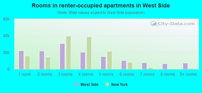
- Rooms in renter-occupied apartments in West Side
- 4311 room
- 1,5902 rooms
- 1,9473 rooms
- 2,5744 rooms
- 3,5575 rooms
- 3,8046 rooms
- 1,6477 rooms
- 9668 rooms
- 5259+ rooms
Owner-occupied
Renter-occupied
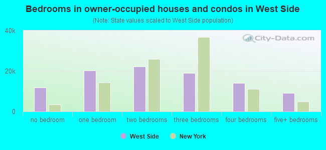
- Bedrooms in owner-occupied houses and condos in West Side
- 0no bedroom
- 6021 bedroom
- 2,3282 bedrooms
- 2,1193 bedrooms
- 2,8034 bedrooms
- 7655+ bedrooms
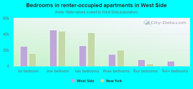
- Bedrooms in renter-occupied apartments in West Side
- 431no bedroom
- 3,1351 bedroom
- 5,3732 bedrooms
- 4,2363 bedrooms
- 1,2514 bedrooms
- 5975+ bedrooms
Average number of cars or other vehicles available in houses/condos:
Average number of cars or other vehicles available in apartments:
| This neighborhood: | |
| Buffalo: |
Average number of cars or other vehicles available in apartments:
| Here: | 1.0 |
| city: | 0.9 |
Percentage of units with a mortgage:
| West Side: | 63.1% |
| Buffalo: | 48.3% |
Housing prices:
- Average estimated value of detached houses in 2022 (26.0% of all units):
West Side: $254,816 New York: $476,719
- Average estimated value of housing units in 2-unit structures in 2022 (41.6% of all units):
This neighborhood: $226,005 New York: $713,077
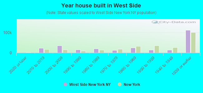
- Year house built in West Side
- 02020 or later
- 3,3642010 to 2019
- 8582000 to 2009
- 1,0991990 to 1999
- 1,3761980 to 1989
- 1,6951970 to 1979
- 1,4421960 to 1969
- 1,9221950 to 1959
- 1,6071940 to 1949
- 18,2401939 or earlier
City-data.com crime index for city in 2020 (higher means more crime):
| City: | 441.3 |
| U.S. average: | 219.5 |
Travel time to work (commute)
![Travel time to work (commute)]()
- 654Less than 5 minutes
- 1,8275 to 9 minutes
- 3,86610 to 14 minutes
- 2,91415 to 19 minutes
- 2,42220 to 24 minutes
- 1,54625 to 29 minutes
- 1,86930 to 34 minutes
- 41235 to 39 minutes
- 38740 to 44 minutes
- 1,06645 to 59 minutes
- 49660 to 89 minutes
- 11590 or more minutes

Means of transportation to work
![Means of transportation to work]()
- 64.2%15,322Drove a car alone
- 10.5%2,497Carpooled
- 9.6%2,285Bus
- 0.1%20Subway or elevated rail
- 0.3%60Light rail, streetcar or trolley
- 0.2%47Taxi
- 7.5%1,793Motorcycle
- 2.3%555Bicycle
- 12.0%2,863Walked
- 3.9%926Other means
- 12.2%2,909Worked at home

Time leaving home to go to work
![Time leaving home to go to work]()
- 61912:00 a.m. to 4:59 a.m.
- 2665:00 a.m. to 5:29 a.m.
- 965:30 a.m. to 5:59 a.m.
- 3626:00 a.m. to 6:29 a.m.
- 5726:30 a.m. to 6:59 a.m.
- 1,9527:00 a.m. to 7:29 a.m.
- 2,3497:30 a.m. to 7:59 a.m.
- 2,3158:00 a.m. to 8:29 a.m.
- 2,3898:30 a.m. to 8:59 a.m.
- 1,6039:00 a.m. to 9:59 a.m.
- 84110:00 a.m. to 10:59 a.m.
- 18411:00 a.m. to 11:59 a.m.
- 1,56612:00 p.m. to 3:59 p.m.
- 1,4844:00 p.m. to 11:59 p.m.

Occupations of males:
- Percentage of males in management occupations (except farmers):
Here: 12.2% city: 8.7%
- Percentage of males in business and financial operations occupations:
Here: 8.5% city: 4.0%
- Percentage of males in computer and mathematical occupations:
Here: 6.2% city: 3.5%
- Percentage of males in architecture and engineering occupations:
Here: 2.6% city: 2.9%
- Percentage of males in life, physical, and social science occupations:
Here: 1.2% city: 1.0%
- Percentage of males in community and social services occupations:
Here: 1.3% city: 1.9%
- Percentage of males in legal occupations:
Here: 1.4% city: 1.8%
- Percentage of males in education, training, and library occupations:
Here: 9.6% city: 4.7%
- Percentage of males in arts, design, entertainment, sports, and media occupations:
Here: 2.3% city: 1.7%
- Percentage of males in healthcare practitioners and technical occupations:
Here: 2.0% city: 2.6%
- Percentage of males in service occupations:
Here: 16.3% city: 21.5%
- Percentage of males in sales and office occupations:
Here: 17.4% city: 15.9%
- Percentage of males in construction, extraction, and maintenance occupations:
Here: 7.4% city: 5.6%
- Percentage of males in production occupations:
Here: 4.4% city: 7.3%
- Percentage of males in transportation occupations:
Here: 3.1% city: 5.1%
- Percentage of males in material moving occupations:
Here: 1.5% city: 7.6%
Occupations of females:
- Percentage of females in management occupations (except farmers):
Here: 8.6% city: 7.4%
- Percentage of females in business and financial operations occupations:
Here: 8.7% city: 5.0%
- Percentage of females in computer and mathematical occupations:
Here: 2.3% city: 1.1%
- Percentage of females in community and social services occupations:
Here: 4.6% city: 3.5%
- Percentage of females in legal occupations:
Here: 2.0% city: 1.8%
- Percentage of females in education, training, and library occupations:
Here: 12.1% city: 10.9%
- Percentage of females in arts, design, entertainment, sports, and media occupations:
Here: 5.7% city: 1.8%
- Percentage of females in healthcare practitioners and technical occupations:
Here: 8.3% city: 8.0%
- Percentage of females in service occupations:
Here: 18.5% city: 26.7%
- Percentage of females in sales and office occupations:
Here: 23.4% city: 25.5%
- Percentage of females in production occupations:
Here: 1.6% city: 3.4%
- Percentage of females in material moving occupations:
Here: 1.5% city: 2.0%
Percentage of people 16-64 in Armed Forces:
| West Side: | 0.2% |
| Buffalo: | 0.2% |
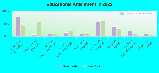
Education in this neighborhood (subdivision or community):
- Percentage of people 3 years and older in K-12 schools:
West Side: 27.5% Buffalo: 16.7%
- Percentage of people 3 years and older in undergraduate colleges:
West Side: 5.7% Buffalo: 6.6%
- Percentage of people 3 years and older in grad. or professional schools:
West Side: 8.1% Buffalo: 2.5%
- Percentage of students K-12 enrolled in private schools:
West Side: 38.7% Buffalo: 11.8%
Percentage of population below poverty level:
| West Side: | 22.0% |
| Buffalo: | 23.6% |
Median year renter moved in (as recorded in 2022):
| West Side: | 2229 |
| Buffalo: | 2019 |
Percentage of married-couple families with both working:
| West Side: | 126.6% |
| Buffalo: | 64.1% |
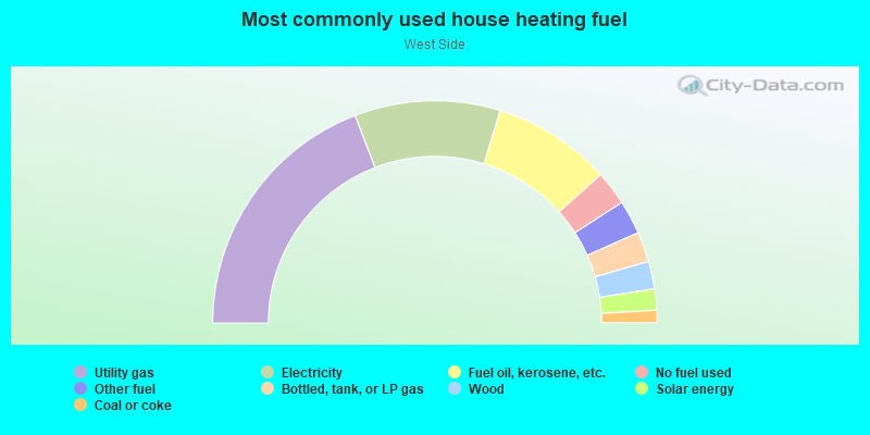
- 67.7%Utility gas
- 8.9%Electricity
- 7.1%Bottled, tank, or LP gas
- 4.8%Solar energy
- 3.8%Fuel oil, kerosene, etc.
- 2.2%Other fuel
- 2.0%Wood
- 2.0%No fuel used
- 1.5%Coal or coke
Limited-access highways (interstate or state) in this neighborhood:
I- 190
Length: 0.62 miles
Directions: N-S, SE-NW
Directions: N-S, SE-NW
Highways in this neighborhood:
Niagara St (State Hwy 266)
Length: 2.68 miles
Directions: N-S, SE-NW
Address range: 336 to 1530
Directions: N-S, SE-NW
Address range: 336 to 1530
Roads and streets:
West Ave
Length: 2.78 miles
Directions: N-S, SE-NW
Address range: 64 to 1415
Directions: N-S, SE-NW
Address range: 64 to 1415
Breckenridge St
Length: 1.64 miles
Direction: E-W
Address range: 1 to 699
Direction: E-W
Address range: 1 to 699
W Ferry St
Length: 1.64 miles
Direction: E-W
Address range: 11 to 639
Direction: E-W
Address range: 11 to 639
Prospect Ave
Length: 1.63 miles
Direction: SE-NW
Address range: 186 to 999
Direction: SE-NW
Address range: 186 to 999
Plymouth Ave
Length: 1.61 miles
Directions: N-S, SE-NW
Address range: 3 to 799
Directions: N-S, SE-NW
Address range: 3 to 799
Busti Ave
Length: 1.57 miles
Directions: E-W, N-S, SE-NW
Address range: 200 to 999
Directions: E-W, N-S, SE-NW
Address range: 200 to 999
Auburn Ave
Length: 1.57 miles
Direction: E-W
Address range: 1 to 629
Direction: E-W
Address range: 1 to 629
Grant St
Length: 1.56 miles
Directions: N-S, SE-NW, SW-NE
Address range: 1 to 813
Directions: N-S, SE-NW, SW-NE
Address range: 1 to 813
W Delavan Ave
Length: 1.53 miles
Direction: E-W
Address range: 1 to 599
Direction: E-W
Address range: 1 to 599
Porter Ave
Length: 1.48 miles
Directions: E-W, SE-NW, SW-NE
Address range: 1 to 611
Directions: E-W, SE-NW, SW-NE
Address range: 1 to 611
Bird Ave
Length: 1.48 miles
Direction: E-W
Address range: 1 to 599
Direction: E-W
Address range: 1 to 599
Potomac Ave
Length: 1.46 miles
Direction: E-W
Address range: 1 to 599
Direction: E-W
Address range: 1 to 599
Fargo Ave
Length: 1.44 miles
Direction: SE-NW
Address range: 1 to 699
Direction: SE-NW
Address range: 1 to 699
Massachusetts Ave
Length: 1.37 miles
Directions: E-W, SW-NE
Address range: 1 to 599
Directions: E-W, SW-NE
Address range: 1 to 599
Lafayette Ave
Length: 1.32 miles
Direction: E-W
Address range: 1 to 570
Direction: E-W
Address range: 1 to 570
Rhode Island St
Length: 1.30 miles
Direction: SW-NE
Address range: 26 to 599
Direction: SW-NE
Address range: 26 to 599
Normal Ave
Length: 1.11 miles
Direction: SE-NW
Address range: 1 to 599
Direction: SE-NW
Address range: 1 to 599
Jersey St
Length: 1.10 miles
Direction: SW-NE
Address range: 2 to 499
Direction: SW-NE
Address range: 2 to 499
Richmond Ave
Length: 1.06 miles
Directions: N-S, SE-NW
Address range: 1 to 829
Directions: N-S, SE-NW
Address range: 1 to 829
7th St
Length: 1.00 miles
Direction: SE-NW
Address range: 243 to 999
Direction: SE-NW
Address range: 243 to 999
Hampshire St
Length: 0.99 miles
Direction: SW-NE
Address range: 1 to 499
Direction: SW-NE
Address range: 1 to 499
Pennsylvania St
Length: 0.98 miles
Direction: SW-NE
Address range: 1 to 406
Direction: SW-NE
Address range: 1 to 406
14th St
Length: 0.96 miles
Direction: SE-NW
Address range: 1 to 499
Direction: SE-NW
Address range: 1 to 499
Vermont St
Length: 0.92 miles
Direction: SW-NE
Address range: 1 to 381
Direction: SW-NE
Address range: 1 to 381
Herkimer St
Length: 0.92 miles
Directions: E-W, N-S
Address range: 1 to 499
Directions: E-W, N-S
Address range: 1 to 499
Ashland Ave
Length: 0.88 miles
Direction: N-S
Address range: 241 to 770
Direction: N-S
Address range: 241 to 770
Dewitt St
Length: 0.84 miles
Direction: N-S
Address range: 1 to 499
Direction: N-S
Address range: 1 to 499
Hudson St
Length: 0.77 miles
Direction: SW-NE
Address range: 1 to 310
Direction: SW-NE
Address range: 1 to 310
15th St
Length: 0.75 miles
Direction: SE-NW
Address range: 1 to 399
Direction: SE-NW
Address range: 1 to 399
Parkdale Ave
Length: 0.73 miles
Directions: N-S, SW-NE
Address range: 1 to 389
Directions: N-S, SW-NE
Address range: 1 to 389
Hoyt St
Length: 0.73 miles
Direction: N-S
Address range: 1 to 365
Direction: N-S
Address range: 1 to 365
Baynes St
Length: 0.73 miles
Direction: N-S
Address range: 1 to 380
Direction: N-S
Address range: 1 to 380
Virginia St
Length: 0.71 miles
Direction: SW-NE
Address range: 2 to 315
Direction: SW-NE
Address range: 2 to 315
Connecticut St
Length: 0.71 miles
Direction: SW-NE
Address range: 166 to 455
Direction: SW-NE
Address range: 166 to 455
Maryland St
Length: 0.65 miles
Direction: SW-NE
Address range: 1 to 314
Direction: SW-NE
Address range: 1 to 314
Norwood Ave
Length: 0.62 miles
Direction: N-S
Address range: 237 to 599
Direction: N-S
Address range: 237 to 599
Albany St
Length: 0.59 miles
Direction: E-W
Address range: 1 to 299
Direction: E-W
Address range: 1 to 299
Baird Dr (Moore Dr)
Length: 0.56 miles
Directions: E-W, SE-NW
Directions: E-W, SE-NW
Arkansas St
Length: 0.53 miles
Direction: E-W
Address range: 1 to 211
Direction: E-W
Address range: 1 to 211
Barton St
Length: 0.51 miles
Direction: N-S
Address range: 1 to 299
Direction: N-S
Address range: 1 to 299
Garner Ave
Length: 0.51 miles
Direction: E-W
Address range: 1 to 199
Direction: E-W
Address range: 1 to 199
Dorchester Rd
Length: 0.48 miles
Directions: E-W, SE-NW
Address range: 1 to 199
Directions: E-W, SE-NW
Address range: 1 to 199
4th St
Length: 0.45 miles
Direction: SE-NW
Address range: 400 to 699
Direction: SE-NW
Address range: 400 to 699
Trenton Ave
Length: 0.45 miles
Direction: SE-NW
Address range: 100 to 499
Direction: SE-NW
Address range: 100 to 499
Columbus Pkwy
Length: 0.44 miles
Direction: SE-NW
Address range: 600 to 807
Direction: SE-NW
Address range: 600 to 807
Congress St
Length: 0.44 miles
Direction: N-S
Address range: 1 to 299
Direction: N-S
Address range: 1 to 299
Forest Ave
Length: 0.43 miles
Direction: E-W
Address range: 97 to 255
Direction: E-W
Address range: 97 to 255
York St
Length: 0.43 miles
Direction: SW-NE
Address range: 2 to 168
Direction: SW-NE
Address range: 2 to 168
Colonial Cir
Length: 0.41 miles
Directions: E-W, SE-NW, SW-NE
Address range: 1 to 98
Directions: E-W, SE-NW, SW-NE
Address range: 1 to 98
School St
Length: 0.37 miles
Direction: SW-NE
Address range: 1 to 199
Direction: SW-NE
Address range: 1 to 199
Sheridan Ter
Length: 0.36 miles
Directions: N-S, SE-NW
Directions: N-S, SE-NW
Dart St
Length: 0.36 miles
Direction: N-S
Address range: 1 to 299
Direction: N-S
Address range: 1 to 299
Highland Ave
Length: 0.35 miles
Direction: E-W
Address range: 200 to 399
Direction: E-W
Address range: 200 to 399
Lexington Ave
Length: 0.35 miles
Direction: E-W
Address range: 186 to 399
Direction: E-W
Address range: 186 to 399
Anderson Pl
Length: 0.34 miles
Direction: E-W
Address range: 1 to 128
Direction: E-W
Address range: 1 to 128
Gelston St
Length: 0.34 miles
Direction: N-S
Address range: 1 to 199
Direction: N-S
Address range: 1 to 199
Pooley Pl
Length: 0.34 miles
Direction: E-W
Address range: 1 to 199
Direction: E-W
Address range: 1 to 199
Bidwell Pkwy
Length: 0.33 miles
Direction: SW-NE
Address range: 1 to 160
Direction: SW-NE
Address range: 1 to 160
Livingston St
Length: 0.33 miles
Direction: N-S
Address range: 1 to 199
Direction: N-S
Address range: 1 to 199
Hawley St
Length: 0.31 miles
Direction: N-S
Address range: 1 to 199
Direction: N-S
Address range: 1 to 199
W Utica St
Length: 0.31 miles
Direction: E-W
Address range: 525 to 699
Direction: E-W
Address range: 525 to 699
Lakeview Ave
Length: 0.30 miles
Direction: SE-NW
Address range: 1 to 199
Direction: SE-NW
Address range: 1 to 199
Efner St
Length: 0.30 miles
Directions: SE-NW, SW-NE
Address range: 100 to 382
Directions: SE-NW, SW-NE
Address range: 100 to 382
18th St
Length: 0.30 miles
Direction: SE-NW
Address range: 1 to 199
Direction: SE-NW
Address range: 1 to 199
10th St
Length: 0.30 miles
Direction: SE-NW
Address range: 66 to 199
Direction: SE-NW
Address range: 66 to 199
19th St
Length: 0.30 miles
Direction: SE-NW
Address range: 1 to 199
Direction: SE-NW
Address range: 1 to 199
Whitney Pl
Length: 0.30 miles
Direction: SE-NW
Address range: 146 to 299
Direction: SE-NW
Address range: 146 to 299
California St
Length: 0.29 miles
Direction: E-W
Address range: 1 to 99
Direction: E-W
Address range: 1 to 99
Claremont Ave
Length: 0.27 miles
Directions: N-S, SE-NW
Address range: 1 to 139
Directions: N-S, SE-NW
Address range: 1 to 139
Greenwood Pl
Length: 0.27 miles
Direction: N-S
Address range: 1 to 199
Direction: N-S
Address range: 1 to 199
Bradley St
Length: 0.26 miles
Direction: E-W
Address range: 1 to 120
Direction: E-W
Address range: 1 to 120
Ardmore Pl
Length: 0.26 miles
Direction: E-W
Address range: 1 to 99
Direction: E-W
Address range: 1 to 99
Manchester Pl
Length: 0.26 miles
Direction: E-W
Address range: 1 to 99
Direction: E-W
Address range: 1 to 99
Chenango St
Length: 0.26 miles
Direction: SE-NW
Address range: 69 to 199
Direction: SE-NW
Address range: 69 to 199
Arnold St
Length: 0.24 miles
Direction: E-W
Address range: 1 to 99
Direction: E-W
Address range: 1 to 99
Putnam St
Length: 0.23 miles
Direction: N-S
Address range: 1 to 199
Direction: N-S
Address range: 1 to 199
Elmwood Ave
Length: 0.22 miles
Direction: N-S
Address range: 524 to 669
Direction: N-S
Address range: 524 to 669
Ferry Cir
Length: 0.21 miles
Directions: SE-NW, SW-NE
Directions: SE-NW, SW-NE
Ferguson Ave
Length: 0.19 miles
Direction: E-W
Address range: 1 to 99
Direction: E-W
Address range: 1 to 99
Boyd St
Length: 0.18 miles
Direction: E-W
Address range: 3 to 99
Direction: E-W
Address range: 3 to 99
Columbus Pkwy W
Length: 0.17 miles
Direction: SW-NE
Address range: 100 to 166
Direction: SW-NE
Address range: 100 to 166
Gill Aly
Length: 0.17 miles
Direction: N-S
Address range: 1 to 99
Direction: N-S
Address range: 1 to 99
Letchworth St
Length: 0.17 miles
Direction: E-W
Address range: 1 to 73
Direction: E-W
Address range: 1 to 73
Perkins Pl
Length: 0.17 miles
Direction: E-W
Address range: 1 to 99
Direction: E-W
Address range: 1 to 99
Helen St
Length: 0.17 miles
Direction: E-W
Address range: 1 to 99
Direction: E-W
Address range: 1 to 99
Symphony Cir
Length: 0.17 miles
Directions: E-W, SE-NW
Directions: E-W, SE-NW
Danforth St
Length: 0.16 miles
Direction: N-S
Address range: 1 to 99
Direction: N-S
Address range: 1 to 99
Malta Pl
Length: 0.16 miles
Directions: SE-NW, SW-NE
Address range: 1 to 99
Directions: SE-NW, SW-NE
Address range: 1 to 99
Auchinvole Ave
Length: 0.15 miles
Direction: E-W
Address range: 1 to 99
Direction: E-W
Address range: 1 to 99
Bremen St
Length: 0.15 miles
Direction: SE-NW
Address range: 1 to 99
Direction: SE-NW
Address range: 1 to 99
Lowell Pl
Length: 0.15 miles
Direction: SE-NW
Address range: 1 to 99
Direction: SE-NW
Address range: 1 to 99
W Tupper St
Length: 0.15 miles
Direction: SE-NW
Address range: 247 to 399
Direction: SE-NW
Address range: 247 to 399
Cobb Aly
Length: 0.15 miles
Direction: SE-NW
Direction: SE-NW
Lawrence Pl
Length: 0.15 miles
Direction: SE-NW
Address range: 1 to 99
Direction: SE-NW
Address range: 1 to 99
Essex St
Length: 0.15 miles
Direction: SE-NW
Address range: 1 to 99
Direction: SE-NW
Address range: 1 to 99
Brayton St
Length: 0.15 miles
Direction: SE-NW
Address range: 57 to 199
Direction: SE-NW
Address range: 57 to 199
Winter St
Length: 0.15 miles
Direction: SE-NW
Address range: 1 to 99
Direction: SE-NW
Address range: 1 to 99
16th St
Length: 0.15 miles
Direction: SE-NW
Address range: 121 to 199
Direction: SE-NW
Address range: 121 to 199
Ketchum Pl
Length: 0.15 miles
Direction: SE-NW
Address range: 1 to 99
Direction: SE-NW
Address range: 1 to 99
Osborne Aly
Length: 0.15 miles
Direction: SE-NW
Direction: SE-NW
Summer St
Length: 0.14 miles
Directions: E-W, SE-NW
Address range: 358 to 499
Directions: E-W, SE-NW
Address range: 358 to 499
Harbor Walk
Length: 0.14 miles
Direction: SW-NE
Address range: 1 to 99
Direction: SW-NE
Address range: 1 to 99
Penfield St
Length: 0.14 miles
Direction: E-W
Address range: 1 to 99
Direction: E-W
Address range: 1 to 99
Gren-Way Aly
Length: 0.12 miles
Direction: N-S
Address range: 1 to 99
Direction: N-S
Address range: 1 to 99
Gull St
Length: 0.12 miles
Direction: E-W
Address range: 1 to 99
Direction: E-W
Address range: 1 to 99
Fernwood Ave
Length: 0.12 miles
Direction: SW-NE
Direction: SW-NE
Sally Mae Cunningham Dr
Length: 0.11 miles
Direction: SW-NE
Direction: SW-NE
Shields Ave
Length: 0.11 miles
Direction: SE-NW
Address range: 1 to 99
Direction: SE-NW
Address range: 1 to 99
S Putnam St
Length: 0.10 miles
Direction: N-S
Address range: 1 to 99
Direction: N-S
Address range: 1 to 99
Peace Bridge Plz
Length: 0.10 miles
Directions: E-W, SE-NW
Address range: 1 to 69
Directions: E-W, SE-NW
Address range: 1 to 69
Sherwood St
Length: 0.10 miles
Direction: N-S
Address range: 1 to 99
Direction: N-S
Address range: 1 to 99
Anthony Tauriello Dr
Length: 0.09 miles
Direction: SW-NE
Direction: SW-NE
Moore Dr
Length: 0.09 miles
Directions: E-W, SW-NE
Directions: E-W, SW-NE
Hope Way
Length: 0.09 miles
Direction: SW-NE
Direction: SW-NE
Cordage Aly
Length: 0.07 miles
Direction: N-S
Address range: 1 to 99
Direction: N-S
Address range: 1 to 99
Landis Pl
Length: 0.06 miles
Direction: N-S
Direction: N-S
Sloan St
Length: 0.05 miles
Direction: E-W
Direction: E-W
Reynolds Aly
Length: 0.05 miles
Direction: SE-NW
Direction: SE-NW
Haggart Aly
Length: 0.05 miles
Direction: N-S
Direction: N-S
Railroad features:
Penn Central RR (Csx RR)
Length: 2.08 miles
Directions: N-S, SE-NW
Directions: N-S, SE-NW
Erie-Lackawanna RR
Length: 0.32 miles
Directions: E-W, SW-NE
Directions: E-W, SW-NE