Property valuation of U S Hy 290, Austin, TX (tax assessments)
Other nearby streets: Abbate Circle  Oak Springs Drive (1)
Oak Springs Drive (2)
Oak Springs Drive (3)
Wayneroy Drive
Oak Springs Drive (1)
Oak Springs Drive (2)
Oak Springs Drive (3)
Wayneroy Drive
Oak Springs Drive (1)
Oak Springs Drive (2)
Oak Springs Drive (3)
Wayneroy Drive
Listed properties vs overall distribution of properties in Austin, TX:
Advertisements
U S Hy 290
Austin, TX
Find on map >>
Owner: CITY OF AUSTIN
Property type: Real
Property tax division code: D2 - Acreage (Non-Ag)
Appraisal or Tax Year: 2013
Total market land value: $761,956
Total market value for property: $761,956 (it was $761,956 in 2009)
Land size: 2,539,853 square feet
Austin, TX
Find on map >>
Owner: CITY OF AUSTIN
Property type: Real
Property tax division code: D2 - Acreage (Non-Ag)
Appraisal or Tax Year: 2013
Total market land value: $761,956
Total market value for property: $761,956 (it was $761,956 in 2009)
Land size: 2,539,853 square feet
U S Hy 290
Austin, TX
Find on map >>
Owner: CITY OF SUNSET VALLEY & CLAY COLLINS
Property type: Real
Property tax division code: C1 - Vacant Lot
Appraisal or Tax Year: 2013
Total market land value: $11,680
Total market value for property: $11,680 (it was $11,680 in 2009)
Land size: 8,111 square feet
Austin, TX
Find on map >>
Owner: CITY OF SUNSET VALLEY & CLAY COLLINS
Property type: Real
Property tax division code: C1 - Vacant Lot
Appraisal or Tax Year: 2013
Total market land value: $11,680
Total market value for property: $11,680 (it was $11,680 in 2009)
Land size: 8,111 square feet
U S Hy 290
Austin, TX
Find on map >>
Owner: CITY OF SUNSET VALLEY & CLAY COLLINS
Property type: Real
Property tax division code: D2 - Acreage (Non-Ag)
Appraisal or Tax Year: 2013
Total market land value: $140,760
Total market value for property: $140,760 (it was $140,760 in 2009)
Land size: 153,288 square feet
U S Hy 290
Austin, TX
Find on map >>
Owner: CITY OF SUNSET VALLEY & CLAY COLLINS
Property type: Real
Property tax division code: D2 - Acreage (Non-Ag)
Appraisal or Tax Year: 2013
Total market land value: $235,000
Total market value for property: $235,000 (it was $235,000 in 2009)
Land size: 800,415 square feet
U S Hy 290
Austin, TX 78736
Find on map >>
Owner: BUFFALO EQUITIES LTD
Property type: Real
Property tax division code: F1 - Commercial
Appraisal or Tax Year: 2013
Total market land value: $64,440
Total market value for property: $64,440 (it was $64,440 in 2009)
Land size: 233,917 square feet
Austin, TX 78736
Find on map >>
Owner: BUFFALO EQUITIES LTD
Property type: Real
Property tax division code: F1 - Commercial
Appraisal or Tax Year: 2013
Total market land value: $64,440
Total market value for property: $64,440 (it was $64,440 in 2009)
Land size: 233,917 square feet
U S Hy 290
Austin, TX 78653
Find on map >>
Owner: SG LAND HOLDINGS LLC
Property type: Real
Property tax division code: D2 - Acreage (Non-Ag)
Appraisal or Tax Year: 2013
Total market land value: $213,088
Total market value for property: $14,432 (it was $426,176 in 2009)
Land size: 928,211 square feet
Austin, TX 78653
Find on map >>
Owner: SG LAND HOLDINGS LLC
Property type: Real
Property tax division code: D2 - Acreage (Non-Ag)
Appraisal or Tax Year: 2013
Total market land value: $213,088
Total market value for property: $14,432 (it was $426,176 in 2009)
Land size: 928,211 square feet
U S Hy 290
Austin, TX 78621
Find on map >>
Owner: R HIDELL
Property type: Real
Property tax division code: D1 - Acreage (Ag) 1-D-1
Appraisal or Tax Year: 2013
Total market land value: $70,740
Total market value for property: $7,074 (it was $70,740 in 2009)
Land size: 102,714 square feet
Austin, TX 78621
Find on map >>
Owner: R HIDELL
Property type: Real
Property tax division code: D1 - Acreage (Ag) 1-D-1
Appraisal or Tax Year: 2013
Total market land value: $70,740
Total market value for property: $7,074 (it was $70,740 in 2009)
Land size: 102,714 square feet
U S Hy 290
Austin, TX 78621
Find on map >>
Owner: CENTEX LAND LTD
Property type: Real
Property tax division code: D1 - Acreage (Ag) 1-D-1
Appraisal or Tax Year: 2013
Total market land value: $1,100,910
Total market value for property: $1,100,910 (it was $1,100,910 in 2009)
Land size: 3,197,043 square feet
Austin, TX 78621
Find on map >>
Owner: CENTEX LAND LTD
Property type: Real
Property tax division code: D1 - Acreage (Ag) 1-D-1
Appraisal or Tax Year: 2013
Total market land value: $1,100,910
Total market value for property: $1,100,910 (it was $1,100,910 in 2009)
Land size: 3,197,043 square feet
U S Hy 290
Austin, TX 78737
Find on map >>
Owner: BRYAN JAMAIL
Property type: Real
Property tax division code: A1 - Single Family Residence
Appraisal or Tax Year: 2013
Total market land value: $15,100
Total market value for property: $15,100 (it was $15,100 in 2009)
Land size: 13,155 square feet
Austin, TX 78737
Find on map >>
Owner: BRYAN JAMAIL
Property type: Real
Property tax division code: A1 - Single Family Residence
Appraisal or Tax Year: 2013
Total market land value: $15,100
Total market value for property: $15,100 (it was $15,100 in 2009)
Land size: 13,155 square feet
U S Hy 290
Austin, TX 78653
Find on map >>
Owner: MANOR INDEPENDENT SCHOOL DISTR
Property type: Real
Property tax division code: F1 - Commercial
Appraisal or Tax Year: 2013
Total market land value: $597,210
Total market building value: $291,001 (it was $894,237 in 2009)
Total market value for property: $888,211 (it was $894,237 in 2009)
Land size: 59,721 square feet
Property improvements: 1st floor, Canopy, Light poles, Paved area, Sketch only
Roof Style: Gable
Roof Covering: Composition
Foundation: Slab
Other nearby streets: Abbate Circle
Oak Springs Drive (1)
Oak Springs Drive (2)
Oak Springs Drive (3)
Wayneroy Drive
Oak Springs Drive (1)
Oak Springs Drive (2)
Oak Springs Drive (3)
Wayneroy Drive

Recent posts about Austin, Texas on our local forum with over 2,400,000 registered users. Austin is mentioned 145,870 times on our forum:
 | Why tech talent is in the process of abandoning Austin (34 replies) |
| Austin Trip Reflection (30 replies) |
| Let’s be honest. What’s your take on Austin and newcomers? (42 replies) |
| How much longer does Austin have? (338 replies) |
| UT Austin Policy Report Shows Austin's the Only Fast-Growing City Losing African-Americans (150 replies) |
| Latest crime statistics for Austin, 2016 (2 replies) |
Settings
X

Recently Added Photos

Austin, TX

Austin, TX

Austin, TX

Austin, TX
Austin, TX

Austin, TX

Austin, TX

Austin, TX

Austin, TX

Austin, TX

Austin, TX

Austin, TX
Request disassociating your name from street-level assessment address

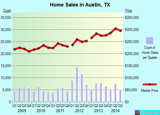
Recent home sales, price trends, and home value evaluator powered by Onboard Informatics
© 2024 Onboard Informatics. Information is deemed reliable but not guaranteed.
© 2024 Onboard Informatics. Information is deemed reliable but not guaranteed.
Some parts © 2024 Advameg, Inc.
Compilation, repackaging, or reproduction prohibited. Users are forewarned that it is incumbent upon them to verify information with the responsible state agency. Advameg, Inc. does not guarantee the data presented is up-to-date nor does it assume responsibility for updating it. Therefore any names, owners or addresses may have changed. Use of any information published here to contact the persons might be prohibited by the law.