Bridge Statistics for Alabaster, Alabama (AL)
Condition, Traffic, Stress, Structural Evaluation, Project Costs
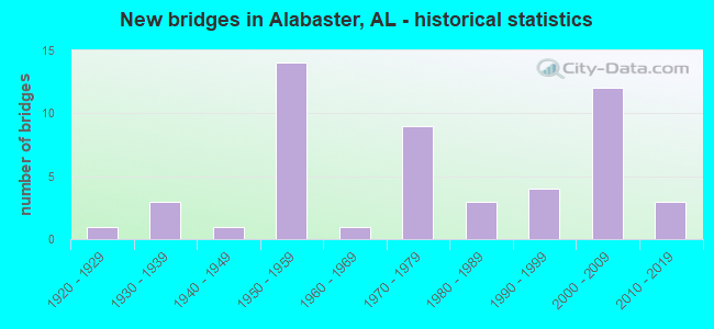
- New bridges - historical statistics
- 11920-1929
- 31930-1939
- 11940-1949
- 141950-1959
- 11960-1969
- 91970-1979
- 31980-1989
- 41990-1999
- 122000-2009
- 32010-2019

- Reconstructed bridges - Historical Statistics
- 11930-1939
- 01940-1949
- 01950-1959
- 01960-1969
- 21970-1979
- 11980-1989


- Bridge Condition - Deck
- 16.7%Very good
- 12.5%Good
- 41.7%Satisfactory
- 29.2%Fair

- Bridge Condition - Superstructure
- 25.0%Very good
- 16.7%Good
- 33.3%Satisfactory
- 25.0%Fair

- Bridge Condition - Substructure
- 12.5%Very good
- 29.2%Good
- 50.0%Satisfactory
- 8.3%Fair

- Bridge Condition - Channel
- 5.6%Very good
- 41.7%Good
- 38.9%Satisfactory
- 13.9%Fair

- Bridge Condition - Culverts
- 9.5%Very good
- 38.1%Good
- 47.6%Satisfactory
- 4.8%Fair
Find on map >> Show street view
Structure Number: 20121, Location: SUBDIVISION (Lat: 33.182606, Lng: -86.819317), Route carried "on" structure: City street , Year Built: 2006, Status: Open, Structure Length: 1.19m (3.90ft), Average Daily Traffic: 200 (year 2020), Truck Traffic: 1%, Average Future Daily Traffic: 280 (year 2040), Design Load: HS 20, Features Intersected: UT TO SPRING CK, Facility Carried by Structure: GOLDEN MEADOWS DR.
Minimum Vertical Clearance: 30+ m (98+ ft), Kilometerpoint: 0.000, Lanes on structure: 2, Owner: City or Municipal Highway Agency, Approaching Roadway Width: 7.9m (25.9ft), Material/Design: Concrete, Design/Construction: Culvert, Number Of Spans In Main Unit: 4, Length of Maximum Span: 2.4m (7.9ft)
Condition: Channel: Good, Culverts: Very good, Operating Rating: 55.7 metric tons, Method Used To Determine Operating Rating: Load Factor (LF), Inventory Rating: 33.4 metric tons, Method Used To Determine Inventory Rating: Load Factor (LF), Structural Evaluation: Equal to present desirable criteria, Waterway Adequacy: Equal to present desirable criteria, Approach Roadway Alignment: Equal to present desirable criteria, Length Of Structure Improvement: 1.86m (6.10ft), Designated Inspection Frequency: Every 24 months, Inspection Date: May 2020, Bridge Improvement Cost: $774,000, Roadway Improvement Cost: $77,000, Total Project Cost: $851,000 ( Estimate for 2022)
Find on map >> Show street view
Structure Number: 20237, Location: 0.5 MI NO. CR 26 (Lat: 33.257792, Lng: -86.936928), Route carried "on" structure: County highway 17, Year Built: 2011, Status: Open, Structure Length: 1.16m (3.81ft), Average Daily Traffic: 7,730 (year 2022), Truck Traffic: 3%, Average Future Daily Traffic: 11,485 (year 2042), Design Load: HS 20, Features Intersected: BEAVERDAM CREEK
Minimum Vertical Clearance: 30+ m (98+ ft), Kilometerpoint: 0.000, Lanes on structure: 3, Owner: County Highway Agency, Approaching Roadway Width: 12.2m (40.0ft), Skew: 2 degrees, Material/Design: Concrete, Design/Construction: Culvert, Number Of Spans In Main Unit: 3, Length of Maximum Span: 3.9m (12.8ft), Curb-To-Curb Width: 16.2m (53.1ft), Out-to-Out Width: 16.9m (55.4ft)
Condition: Channel: Good, Culverts: Good, Operating Rating: 49.5 metric tons, Method Used To Determine Operating Rating: Load Factor (LF), Inventory Rating: 29.7 metric tons, Method Used To Determine Inventory Rating: Load Factor (LF), Structural Evaluation: Better than present minimum criteria, Deck Geometry: Better than present minimum criteria, Waterway Adequacy: Equal to present desirable criteria, Approach Roadway Alignment: Equal to present desirable criteria, Length Of Structure Improvement: 1.84m (6.04ft), Designated Inspection Frequency: Every 24 months, Inspection Date: January 2022, Bridge Improvement Cost: $617,000, Roadway Improvement Cost: $62,000, Total Project Cost: $679,000 ( Estimate for 2022)
Find on map >> Show street view
Structure Number: 20465, Location: 0.3 MI. NORTH CR 68 (Lat: 33.261125, Lng: -86.795403), Route carried "on" structure: County highway 11, Year Built: 2013, Status: Open, Structure Length: 5.18m (16.99ft), Average Daily Traffic: 12,213 (year 2021), Truck Traffic: 5%, Average Future Daily Traffic: 14,309 (year 2041), Design Load: HS 20, Features Intersected: PEAVINE CREEK
Minimum Vertical Clearance: 30+ m (98+ ft), Kilometerpoint: 0.000, Lanes on structure: 2, Owner: County Highway Agency, Approaching Roadway Width: 8.5m (27.9ft), Material/Design: Prestressed concrete, Design/Construction: Stringer/Multi-beam, Number Of Spans In Main Unit: 1, Number Of Approach Spans: 2, Length of Maximum Span: 27.4m (89.9ft), Curb-To-Curb Width: 12.2m (40.0ft), Out-to-Out Width: 13.0m (42.7ft)
Condition: Deck: Good, Superstructure: Very good, Substructure: Good, Channel: Satisfactory, Operating Rating: 67.8 metric tons, Method Used To Determine Operating Rating: Load Factor (LF), Inventory Rating: 40.6 metric tons, Method Used To Determine Inventory Rating: Load Factor (LF), Structural Evaluation: Better than present minimum criteria, Deck Geometry: Somewhat better than minimum adequacy, Waterway Adequacy: Better than present minimum criteria, Approach Roadway Alignment: Equal to present desirable criteria, Length Of Structure Improvement: 6.21m (20.37ft), Designated Inspection Frequency: Every 24 months, Inspection Date: March 2021, Bridge Improvement Cost: $1,787,000, Roadway Improvement Cost: $179,000, Total Project Cost: $1,966,000 ( Estimate for 2022), Deck Structure Type: Concrete Cast-file-Place
Find on map >> Show street view
Structure Number: 20815, Location: .4MI W. JCT. ST. 119 (Lat: 33.223842, Lng: -86.829658), Route carried "on" structure: County highway 264, Year Built: 2016, Status: Open, Structure Length: 5.49m (18.01ft), Average Daily Traffic: 8,714 (year 2020), Truck Traffic: 9%, Average Future Daily Traffic: 12,948 (year 2040), Design Load: HS 20, Features Intersected: BUCK CREEK
Minimum Vertical Clearance: 30+ m (98+ ft), Kilometerpoint: 0.010, Lanes on structure: 2, Owner: County Highway Agency, Approaching Roadway Width: 10.4m (34.1ft), Material/Design: Prestressed concrete, Design/Construction: Stringer/Multi-beam, Number Of Spans In Main Unit: 3, Length of Maximum Span: 18.3m (60.0ft), Curb or Sidewalk Widths: Left: 2.4m (7.9ft), Right: 0.0m, Curb-To-Curb Width: 10.4m (34.1ft), Out-to-Out Width: 14.9m (48.9ft)
Condition: Deck: Very good, Superstructure: Very good, Substructure: Very good, Channel: Good, Operating Rating: 73.4 metric tons, Method Used To Determine Operating Rating: Load Factor (LF), Inventory Rating: 43.9 metric tons, Method Used To Determine Inventory Rating: Load Factor (LF), Structural Evaluation: Equal to present desirable criteria, Deck Geometry: Meets minimum limits, Waterway Adequacy: Equal to present desirable criteria, Approach Roadway Alignment: Equal to present desirable criteria, Length Of Structure Improvement: 6.52m (21.39ft), Designated Inspection Frequency: Every 24 months, Inspection Date: May 2020, Bridge Improvement Cost: $2,145,000, Roadway Improvement Cost: $215,000, Total Project Cost: $2,360,000 ( Estimate for 2022), Deck Structure Type: Concrete Cast-file-Place
Find on map >> Show street view
Structure Number: 6491, Location: I 65 * CO RD 26 (Lat: 33.214656, Lng: -86.800503), Route carried "under" structure: County highway , Year Built: 1959, Structure Length: 0. m, Average Daily Traffic: 631 (year 2021), Truck Traffic: 16%, Features Intersected: CO RD 26, Facility Carried by Structure: I - 65 SOUTH
Minimum Vertical Clearance: 5.99m (19.65ft), Kilometerpoint: 0.000, Lanes on structure: 2, Lanes under structure: 2, Material/Design: Concrete continuous, Design/Construction: Tee Beam, Length of Maximum Span: 19.5m (64.0ft)
Find on map >> Show street view
Structure Number: 6492, Location: I 65 * CO RD 26 (Lat: 33.214444, Lng: -86.799722), Route carried "under" structure: Business County highway , Year Built: 1959, Structure Length: 0. m, Average Daily Traffic: 526 (year 2021), Truck Traffic: 16%, Features Intersected: CO RD 26, Facility Carried by Structure: I - 65 NORTH
Minimum Vertical Clearance: 5.99m (19.65ft), Kilometerpoint: 0.000, Lanes on structure: 2, Lanes under structure: 2, Material/Design: Concrete continuous, Design/Construction: Tee Beam, Length of Maximum Span: 19.5m (64.0ft)
Find on map >> Show street view
Structure Number: 6493, Location: 3 . 5 MI N JCT CO RD 87 (Lat: 33.218611, Lng: -86.802500), Route carried "under" structure: Alternate County highway , Year Built: 1959, Structure Length: 0. m, Average Daily Traffic: 500 (year 2020), Truck Traffic: 16%, Features Intersected: L * N RR * CO RD 87, Facility Carried by Structure: I 65
Minimum Vertical Clearance: 7.21m (23.65ft), Kilometerpoint: 0.000, Lanes on structure: 2, Lanes under structure: 2, Material/Design: Steel continuous, Design/Construction: Stringer/Multi-beam, Length of Maximum Span: 30.5m (100.1ft)
Find on map >> Show street view
Structure Number: 6494, Location: 3 . 5 MI N JCT CO RD 87 (Lat: 33.218611, Lng: -86.802500), Route carried "under" structure: Alternate City street , Year Built: 1959, Structure Length: 0. m, Average Daily Traffic: 510 (year 2002), Truck Traffic: 16%, Features Intersected: L & N RR / OLD US 31, Facility Carried by Structure: I 65
Minimum Vertical Clearance: 7.21m (23.65ft), Kilometerpoint: 0.000, Lanes on structure: 2, Lanes under structure: 2, Material/Design: Steel continuous, Design/Construction: Stringer/Multi-beam, Length of Maximum Span: 30.5m (100.1ft)
Find on map >> Show street view
Structure Number: 11184, Location: US 31 * I 65 @ ALABASTER (Lat: 33.230469, Lng: -86.806806), Route carried "under" structure: Interstate 65, Year Built: 1974, Structure Length: 0. m, Average Daily Traffic: 77,840 (year 2021), Truck Traffic: 17%, Features Intersected: I - 65, Facility Carried by Structure: AL - 3 (US 31)
Minimum Vertical Clearance: 5.27m (17.29ft), Kilometerpoint: 383.619, Lanes on structure: 6, Lanes under structure: 6, Material/Design: Steel continuous, Design/Construction: Stringer/Multi-beam, Length of Maximum Span: 28.7m (94.2ft)
Find on map >> Show street view
Structure Number: 11356, Location: I 65 * SHELBY CO RD 11 (Lat: 33.258378, Lng: -86.799328), Route carried "under" structure: Interstate 65, Year Built: 1975, Structure Length: 0. m, Average Daily Traffic: 77,840 (year 2020), Truck Traffic: 17%, Features Intersected: I65, Facility Carried by Structure: CO RD 11
Minimum Vertical Clearance: 5.27m (17.29ft), Kilometerpoint: 386.803, Lanes on structure: 2, Lanes under structure: 4, Material/Design: Steel continuous, Design/Construction: Stringer/Multi-beam, Length of Maximum Span: 33.5m (109.9ft)