Bridge Statistics for Albemarle, North Carolina (NC)
Condition, Traffic, Stress, Structural Evaluation, Project Costs
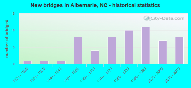
- New bridges - historical statistics
- 11920-1929
- 11930-1939
- 11940-1949
- 81950-1959
- 41960-1969
- 81970-1979
- 101980-1989
- 111990-1999
- 72000-2009
- 82010-2019

- Reconstructed bridges - Historical Statistics
- 11950-1959
- 01960-1969
- 21970-1979
- 11980-1989
- 11990-1999


- Bridge Condition - Deck
- 5.9%Very good
- 76.5%Good
- 14.7%Satisfactory
- 2.9%Fair

- Bridge Condition - Superstructure
- 8.8%Very good
- 70.6%Good
- 11.8%Satisfactory
- 5.9%Fair
- 2.9%Poor

- Bridge Condition - Substructure
- 14.7%Very good
- 58.8%Good
- 11.8%Satisfactory
- 11.8%Fair
- 2.9%Poor

- Bridge Condition - Channel
- 78.4%Good
- 19.6%Satisfactory
- 2.0%Fair

- Bridge Condition - Culverts
- 83.3%Good
- 16.7%Satisfactory
Find on map >> Show street view
Structure Number: 167028, Location: 25 FT. E. JCT. US52 (Lat: 35.361200, Lng: -80.204322), Route carried "on" structure: State highway 1474, Year Built: 1967, Status: Open, Structure Length: 1.34m (4.40ft), Average Daily Traffic: 6,000 (year 2014), Truck Traffic: 7%, Average Future Daily Traffic: 12,000 (year 2040), Design Load: HS 20+Mod, Features Intersected: LITTLE LONG CREEK
Minimum Vertical Clearance: 30+ m (98+ ft), Kilometerpoint: 0.000, Lanes on structure: 4, Owner: State Highway Agency, Approaching Roadway Width: 18.8m (61.7ft), Skew: 1 degrees, Material/Design: Concrete continuous, Design/Construction: Slab, Number Of Spans In Main Unit: 2, Length of Maximum Span: 6.7m (22.0ft), Curb or Sidewalk Widths: Left: 1.4m (4.6ft), Right: 1.4m (4.6ft), Curb-To-Curb Width: 15.9m (52.2ft), Out-to-Out Width: 19.9m (65.3ft)
Condition: Deck: Good, Superstructure: Good, Substructure: Good, Channel: Good, Operating Rating: 41.7 metric tons, Method Used To Determine Operating Rating: Field evaluation and documented engineering judgment, Inventory Rating: 32.6 metric tons, Method Used To Determine Inventory Rating: Field evaluation and documented engineering judgment, Structural Evaluation: Better than present minimum criteria, Deck Geometry: Meets minimum limits, Waterway Adequacy: Better than present minimum criteria, Approach Roadway Alignment: Equal to present desirable criteria, Designated Inspection Frequency: Every 24 months, Inspection Date: August 2021, Deck Structure Type: Concrete Cast-file-Place, Wearing Surface/Protective System: Wearing Surface: Monolithic Concrete
Find on map >> Show street view
Structure Number: 1670281, Location: 0.5 MI. S. JCT. SR1494 (Lat: 35.343667, Lng: -80.202778), Route carried "on" structure: US 52, Year Built: 1986, Status: Open, Structure Length: 1.79m (5.87ft), Average Daily Traffic: 12,500 (year 2013), Truck Traffic: 12%, Average Future Daily Traffic: 25,000 (year 2040), Design Load: HS 20+Mod, Features Intersected: POPLIN BRANCH
Minimum Vertical Clearance: 30+ m (98+ ft), Kilometerpoint: 0.000, Lanes on structure: 4, Base Highway Network: Yes (Inventory Route: 2, Subroute: 52), Owner: State Highway Agency, Approaching Roadway Width: 15.8m (51.8ft), Skew: 4 degrees, Material/Design: Concrete continuous, Design/Construction: Culvert, Number Of Spans In Main Unit: 4, Length of Maximum Span: 3.0m (9.8ft)
Condition: Channel: Good, Culverts: Good, Operating Rating: 89.8 metric tons, Method Used To Determine Operating Rating: Load Factor (LF), Inventory Rating: 65.3 metric tons, Method Used To Determine Inventory Rating: Load Factor (LF), Structural Evaluation: Better than present minimum criteria, Waterway Adequacy: Better than present minimum criteria, Approach Roadway Alignment: Equal to present desirable criteria, Designated Inspection Frequency: Every 24 months, Inspection Date: June 2020
Find on map >> Show street view
Structure Number: 1670282, Location: 0.2 MI. S. JCT. SR1494 (Lat: 35.347003, Lng: -80.204325), Route carried "on" structure: US 52, Year Built: 1986, Status: Open, Structure Length: 7.19m (23.59ft), Average Daily Traffic: 14,000 (year 2013), Truck Traffic: 12%, Average Future Daily Traffic: 28,000 (year 2040), Design Load: HS 20+Mod, Features Intersected: LITTLE LONG CREEK
Minimum Vertical Clearance: 30+ m (98+ ft), Kilometerpoint: 0.000, Lanes on structure: 4, Base Highway Network: Yes (Inventory Route: 2, Subroute: 52), Owner: State Highway Agency, Approaching Roadway Width: 15.8m (51.8ft), Skew: 1 degrees, Material/Design: Prestressed concrete, Design/Construction: Stringer/Multi-beam, Number Of Spans In Main Unit: 4, Length of Maximum Span: 17.3m (56.8ft), Curb or Sidewalk Widths: Left: 1.1m (3.6ft), Right: 1.1m (3.6ft), Curb-To-Curb Width: 14.6m (47.9ft), Out-to-Out Width: 17.8m (58.4ft)
Condition: Deck: Good, Superstructure: Satisfactory, Substructure: Good, Channel: Good, Operating Rating: 89.8 metric tons, Method Used To Determine Operating Rating: Load Factor (LF), Inventory Rating: 39.9 metric tons, Method Used To Determine Inventory Rating: Load Factor (LF), Structural Evaluation: Equal to present minimum criteria, Deck Geometry: High priority of replacement, Waterway Adequacy: Better than present minimum criteria, Approach Roadway Alignment: Equal to present desirable criteria, Designated Inspection Frequency: Every 24 months, Inspection Date: June 2020, Deck Structure Type: Concrete Cast-file-Place, Wearing Surface/Protective System: Wearing Surface: Integral Concrete, Deck Protection: Epoxy Coated Reinforcing
Find on map >> Show street view
Structure Number: 1670283, Location: 0.1 MI. S. JCT. SR1474 (Lat: 35.359967, Lng: -80.205928), Route carried "on" structure: US 52, Year Built: 1986, Status: Open, Structure Length: 0.88m (2.89ft), Average Daily Traffic: 16,500 (year 2018), Truck Traffic: 12%, Average Future Daily Traffic: 33,000 (year 2040), Design Load: HS 20+Mod, Features Intersected: COLEY BRANCH
Minimum Vertical Clearance: 30+ m (98+ ft), Kilometerpoint: 0.000, Lanes on structure: 4, Base Highway Network: Yes (Inventory Route: 2, Subroute: 52), Owner: State Highway Agency, Approaching Roadway Width: 16.1m (52.8ft), Skew: 3 degrees, Material/Design: Concrete continuous, Design/Construction: Culvert, Number Of Spans In Main Unit: 3, Length of Maximum Span: 2.4m (7.9ft)
Condition: Channel: Good, Culverts: Good, Operating Rating: 78.0 metric tons, Method Used To Determine Operating Rating: Load and Resistance Factor (LRFR), Inventory Rating: 59.8 metric tons, Method Used To Determine Inventory Rating: Load and Resistance Factor (LRFR), Structural Evaluation: Better than present minimum criteria, Waterway Adequacy: Better than present minimum criteria, Approach Roadway Alignment: Equal to present desirable criteria, Designated Inspection Frequency: Every 24 months, Inspection Date: June 2020
Find on map >> Show street view
Structure Number: 1670284, Location: 0.01 MI. S. JCT. US52 BUS (Lat: 35.368942, Lng: -80.199922), Route carried "on" structure: US 52, Year Built: 1986, Status: Open, Structure Length: 1.67m (5.48ft), Average Daily Traffic: 14,000 (year 2013), Truck Traffic: 12%, Average Future Daily Traffic: 28,000 (year 2040), Design Load: HS 20+Mod, Features Intersected: TOWN CREEK
Minimum Vertical Clearance: 30+ m (98+ ft), Kilometerpoint: 0.000, Lanes on structure: 4, Base Highway Network: Yes (Inventory Route: 2, Subroute: 52), Owner: State Highway Agency, Approaching Roadway Width: 19.2m (63.0ft), Skew: 5 degrees, Material/Design: Concrete continuous, Design/Construction: Culvert, Number Of Spans In Main Unit: 3, Length of Maximum Span: 3.0m (9.8ft)
Condition: Channel: Good, Culverts: Good, Operating Rating: 34.4 metric tons, Method Used To Determine Operating Rating: Load Factor (LF), Inventory Rating: 20.8 metric tons, Method Used To Determine Inventory Rating: Load Factor (LF), Structural Evaluation: Somewhat better than minimum adequacy, Waterway Adequacy: Better than present minimum criteria, Approach Roadway Alignment: Equal to present desirable criteria, Designated Inspection Frequency: Every 24 months, Inspection Date: June 2020
Find on map >> Show street view
Structure Number: 1670285, Location: 0.1MI.W.JCT.US52 (Lat: 35.338333, Lng: -80.195700), Route carried "on" structure: City street , Year Built: 1957, Status: Open, Structure Length: 0.64m (2.10ft), Average Daily Traffic: 100 (year 1994), Average Future Daily Traffic: 200 (year 2040), Design Load: HS 20, Features Intersected: ROCK CREEK, Facility Carried by Structure: ROCK CREEK PARK DR
Minimum Vertical Clearance: 30+ m (98+ ft), Kilometerpoint: 0.000, Lanes on structure: 2, Owner: City or Municipal Highway Agency, Approaching Roadway Width: 5.4m (17.7ft), Skew: 1 degrees, Material/Design: Concrete continuous, Design/Construction: Culvert, Number Of Spans In Main Unit: 2, Length of Maximum Span: 3.0m (9.8ft)
Condition: Channel: Satisfactory, Culverts: Good, Operating Rating: 41.7 metric tons, Method Used To Determine Operating Rating: Field evaluation and documented engineering judgment, Inventory Rating: 32.6 metric tons, Method Used To Determine Inventory Rating: Field evaluation and documented engineering judgment, Structural Evaluation: Better than present minimum criteria, Waterway Adequacy: Equal to present desirable criteria, Approach Roadway Alignment: Equal to present desirable criteria, Designated Inspection Frequency: Every 24 months, Inspection Date: April 2020
Find on map >> Show street view
Structure Number: 1670286, Location: 1.0MI.W.JCT.MORGAN RD. (Lat: 35.333222, Lng: -80.213781), Route carried "on" structure: City street , Year Built: 1985, Status: Open, Structure Length: 4.87m (15.98ft), Average Daily Traffic: 1,100 (year 2012), Truck Traffic: 7%, Average Future Daily Traffic: 2,200 (year 2040), Features Intersected: LITTLE LONG CREEK, Facility Carried by Structure: ACCESS RD.
Minimum Vertical Clearance: 30+ m (98+ ft), Kilometerpoint: 0.000, Lanes on structure: 2, Owner: City or Municipal Highway Agency, Approaching Roadway Width: 6.0m (19.7ft), Skew: 3 degrees, Material/Design: Prestressed concrete, Design/Construction: Slab, Number Of Spans In Main Unit: 4, Length of Maximum Span: 12.1m (39.7ft), Curb-To-Curb Width: 7.2m (23.6ft), Out-to-Out Width: 7.5m (24.6ft)
Condition: Deck: Good, Superstructure: Good, Substructure: Good, Channel: Good, Operating Rating: 51.7 metric tons, Method Used To Determine Operating Rating: Load Factor (LF), Inventory Rating: 30.8 metric tons, Method Used To Determine Inventory Rating: Load Factor (LF), Structural Evaluation: Better than present minimum criteria, Deck Geometry: High priority of corrective action, Waterway Adequacy: Better than present minimum criteria, Approach Roadway Alignment: Equal to present desirable criteria, Designated Inspection Frequency: Every 24 months, Inspection Date: April 2020, Deck Structure Type: Concrete Precast Panels, Wearing Surface/Protective System: Wearing Surface: Bituminous
Find on map >> Show street view
Structure Number: 167029, Location: 0.1 MI. S. JCT. SR1730 (Lat: 35.364747, Lng: -80.148994), Route carried "on" structure: State highway 740, Year Built: 1930, Status: Open, Structure Length: 1.40m (4.59ft), Average Daily Traffic: 4,900 (year 2013), Truck Traffic: 7%, Average Future Daily Traffic: 9,800 (year 2040), Design Load: HS 15, Features Intersected: MOUNTAIN CREEK
Minimum Vertical Clearance: 30+ m (98+ ft), Kilometerpoint: 0.000, Lanes on structure: 2, Owner: State Highway Agency, Approaching Roadway Width: 7.6m (24.9ft), Material/Design: Concrete continuous, Design/Construction: Culvert, Number Of Spans In Main Unit: 4, Length of Maximum Span: 3.3m (10.8ft)
Condition: Channel: Good, Culverts: Good, Operating Rating: 31.7 metric tons, Method Used To Determine Operating Rating: Field evaluation and documented engineering judgment, Inventory Rating: 24.4 metric tons, Method Used To Determine Inventory Rating: Field evaluation and documented engineering judgment, Structural Evaluation: Equal to present minimum criteria, Waterway Adequacy: Better than present minimum criteria, Approach Roadway Alignment: Equal to present desirable criteria, Designated Inspection Frequency: Every 24 months, Inspection Date: July 2020
Find on map >> Show street view
Structure Number: 1670292, Location: 0.1 MI. E. JCT. SR1421 (Lat: 35.396944, Lng: -80.214833), Route carried "on" structure: State highway 1418, Year Built: 1997, Status: Open, Structure Length: 0.64m (2.10ft), Average Daily Traffic: 2,100 (year 2013), Truck Traffic: 7%, Average Future Daily Traffic: 4,200 (year 2025), Design Load: HS 20+Mod, Features Intersected: UT TO TOWN CREEK
Minimum Vertical Clearance: 30+ m (98+ ft), Kilometerpoint: 0.000, Lanes on structure: 2, Owner: State Highway Agency, Approaching Roadway Width: 6.0m (19.7ft), Skew: 3 degrees, Material/Design: Steel, Design/Construction: Culvert, Number Of Spans In Main Unit: 2, Length of Maximum Span: 2.4m (7.9ft)
Condition: Channel: Good, Culverts: Good, Operating Rating: 89.8 metric tons, Method Used To Determine Operating Rating: Load and Resistance Factor (LRFR), Inventory Rating: 89.8 metric tons, Method Used To Determine Inventory Rating: Load and Resistance Factor (LRFR), Structural Evaluation: Better than present minimum criteria, Waterway Adequacy: Better than present minimum criteria, Approach Roadway Alignment: Equal to present desirable criteria, Designated Inspection Frequency: Every 24 months, Inspection Date: Febuary 2022
Find on map >> Show street view
Structure Number: 1670295, Location: 0.2 MI. E. JCT. NC138 (Lat: 35.339575, Lng: -80.197103), Route carried "on" structure: Business US 52, Year Built: 1957, Status: Open, Structure Length: 0.88m (2.89ft), Average Daily Traffic: 21,000 (year 2013), Truck Traffic: 12%, Average Future Daily Traffic: 42,000 (year 2040), Design Load: HS 20+Mod, Features Intersected: ROCK CREEK
Minimum Vertical Clearance: 30+ m (98+ ft), Kilometerpoint: 0.000, Lanes on structure: 2, Base Highway Network: Yes (Inventory Route: 2, Subroute: 52), Owner: State Highway Agency, Approaching Roadway Width: 28.3m (92.8ft), Material/Design: Concrete, Design/Construction: Culvert, Number Of Spans In Main Unit: 1, Length of Maximum Span: 8.8m (28.9ft)
Condition: Channel: Good, Culverts: Good, Operating Rating: 41.7 metric tons, Method Used To Determine Operating Rating: Field evaluation and documented engineering judgment, Inventory Rating: 32.6 metric tons, Method Used To Determine Inventory Rating: Field evaluation and documented engineering judgment, Structural Evaluation: Better than present minimum criteria, Waterway Adequacy: Better than present minimum criteria, Approach Roadway Alignment: Equal to present desirable criteria, Designated Inspection Frequency: Every 24 months, Inspection Date: June 2020
Find on map >> Show street view
Structure Number: 1670296, Location: 0.1 MI. E. JCT. SR1535 (Lat: 35.383925, Lng: -80.181714), Route carried "on" structure: State highway 1650, Year Built: 1999, Status: Open, Structure Length: 3.71m (12.17ft), Average Daily Traffic: 8,800 (year 2019), Truck Traffic: 8%, Average Future Daily Traffic: 17,600 (year 2040), Design Load: HS 20+Mod, Features Intersected: WINSTON-SALEM SB RAILWAY
Minimum Vertical Clearance: 30+ m (98+ ft), Kilometerpoint: 0.000, Lanes on structure: 2, Owner: State Highway Agency, Approaching Roadway Width: 10.0m (32.8ft), Skew: 1 degrees, Material/Design: Prestressed concrete, Design/Construction: Stringer/Multi-beam, Number Of Spans In Main Unit: 3, Length of Maximum Span: 16.7m (54.8ft), Curb or Sidewalk Widths: Left: 0.0m, Right: 1.5m (4.9ft), Curb-To-Curb Width: 10.3m (33.8ft), Out-to-Out Width: 12.7m (41.7ft)
Condition: Deck: Good, Superstructure: Very good, Substructure: Very good, Operating Rating: 89.8 metric tons, Method Used To Determine Operating Rating: Load Factor (LF), Inventory Rating: 46.2 metric tons, Method Used To Determine Inventory Rating: Load Factor (LF), Structural Evaluation: Equal to present desirable criteria, Deck Geometry: Meets minimum limits, Underclear: Somewhat better than minimum adequacy, Approach Roadway Alignment: Equal to present desirable criteria, Designated Inspection Frequency: Every 24 months, Inspection Date: October 2021, Deck Structure Type: Concrete Cast-file-Place, Wearing Surface/Protective System: Wearing Surface: Integral Concrete, Deck Protection: Epoxy Coated Reinforcing
Find on map >> Show street view
Structure Number: 1670298, Location: .1 MI.N.JCT.AVONDALE AVE. (Lat: 35.365644, Lng: -80.182569), Route carried "on" structure: City street , Year Built: 1998, Status: Open, Structure Length: 1.82m (5.97ft), Average Daily Traffic: 750 (year 2000), Truck Traffic: 7%, Average Future Daily Traffic: 1,500 (year 2040), Design Load: HS 20, Features Intersected: MELCHOR BRANCH, Facility Carried by Structure: SMITH STREET
Minimum Vertical Clearance: 30+ m (98+ ft), Kilometerpoint: 0.000, Lanes on structure: 2, Owner: City or Municipal Highway Agency, Approaching Roadway Width: 9.4m (30.8ft), Material/Design: Prestressed concrete, Design/Construction: Slab, Number Of Spans In Main Unit: 1, Length of Maximum Span: 17.6m (57.7ft), Curb-To-Curb Width: 10.1m (33.1ft), Out-to-Out Width: 10.9m (35.8ft)
Condition: Deck: Good, Superstructure: Good, Substructure: Good, Channel: Good, Operating Rating: 51.7 metric tons, Method Used To Determine Operating Rating: Field evaluation and documented engineering judgment, Inventory Rating: 30.8 metric tons, Method Used To Determine Inventory Rating: Field evaluation and documented engineering judgment, Structural Evaluation: Better than present minimum criteria, Deck Geometry: Equal to present minimum criteria, Waterway Adequacy: Better than present minimum criteria, Approach Roadway Alignment: Equal to present desirable criteria, Designated Inspection Frequency: Every 24 months, Inspection Date: April 2020, Deck Structure Type: Concrete Precast Panels, Wearing Surface/Protective System: Wearing Surface: Bituminous
Find on map >> Show street view
Structure Number: 1670303, Location: 0.15 MI. S. JCT. SR1907 (Lat: 35.314689, Lng: -80.180058), Route carried "on" structure: US 52, Year Built: 2010, Status: Open, Structure Length: 4.78m (15.68ft), Average Daily Traffic: 7,100 (year 2013), Truck Traffic: 14%, Average Future Daily Traffic: 14,200 (year 2040), Design Load: HS 25 or greater, Features Intersected: WINSTON SALEM RR
Minimum Vertical Clearance: 30+ m (98+ ft), Kilometerpoint: 0.000, Lanes on structure: 2, Base Highway Network: Yes (Inventory Route: 2, Subroute: 52), Owner: State Highway Agency, Approaching Roadway Width: 12.4m (40.7ft), Skew: 3 degrees, Material/Design: Steel, Design/Construction: Stringer/Multi-beam, Number Of Spans In Main Unit: 1, Length of Maximum Span: 47.2m (154.9ft), Curb-To-Curb Width: 12.1m (39.7ft), Out-to-Out Width: 13.1m (43.0ft)
Condition: Deck: Good, Superstructure: Good, Substructure: Good, Operating Rating: 89.8 metric tons, Method Used To Determine Operating Rating: Load Factor (LF), Inventory Rating: 66.2 metric tons, Method Used To Determine Inventory Rating: Load Factor (LF), Structural Evaluation: Better than present minimum criteria, Deck Geometry: Somewhat better than minimum adequacy, Underclear: Superior to present desirable criteria, Approach Roadway Alignment: Better than present minimum criteria, Designated Inspection Frequency: Every 24 months, Inspection Date: October 2020, Deck Structure Type: Concrete Cast-file-Place, Wearing Surface/Protective System: Wearing Surface: Monolithic Concrete
Find on map >> Show street view
Structure Number: 1670307, Location: 0.4 MI. N. JCT. SR1906 (Lat: 35.320481, Lng: -80.191322), Route carried "on" structure: US 52, Year Built: 2010, Status: Open, Structure Length: 1.06m (3.48ft), Average Daily Traffic: 9,750 (year 2015), Truck Traffic: 14%, Average Future Daily Traffic: 19,500 (year 2040), Design Load: HS 20+Mod, Features Intersected: ROCK CREEK
Minimum Vertical Clearance: 30+ m (98+ ft), Kilometerpoint: 0.000, Lanes on structure: 2, Base Highway Network: Yes (Inventory Route: 2, Subroute: 52), Owner: State Highway Agency, Approaching Roadway Width: 11.8m (38.7ft), Skew: 4 degrees, Material/Design: Concrete continuous, Design/Construction: Culvert, Number Of Spans In Main Unit: 3, Length of Maximum Span: 2.4m (7.9ft)
Condition: Channel: Good, Culverts: Good, Operating Rating: 89.8 metric tons, Method Used To Determine Operating Rating: Load and Resistance Factor (LRFR), Inventory Rating: 89.8 metric tons, Method Used To Determine Inventory Rating: Load and Resistance Factor (LRFR), Structural Evaluation: Better than present minimum criteria, Waterway Adequacy: Better than present minimum criteria, Approach Roadway Alignment: Equal to present desirable criteria, Designated Inspection Frequency: Every 24 months, Underwater Inspection Frequency: Every 24 months, Inspection Date: October 2020, Underwater Inspection Date: October 2020
Find on map >> Show street view
Structure Number: 1670049, Location: 0.27 MI. E. JCT. NC138 (Lat: 35.339642, Lng: -80.195456), Route carried "under" structure: Business US 52, Year Built: 2004, Structure Length: 0. m, Average Daily Traffic: 5,900 (year 2015), Truck Traffic: 12%, Features Intersected: US52BUS,NC24,NC27,
Minimum Vertical Clearance: 5.28m (17.32ft), Kilometerpoint: 0.000, Lanes on structure: 5, Lanes under structure: 4, Material/Design: Prestressed concrete, Design/Construction: Stringer/Multi-beam, Length of Maximum Span: 20.1m (65.9ft)