Bridge Statistics for Amory, Mississippi (MS)
Condition, Traffic, Stress, Structural Evaluation, Project Costs
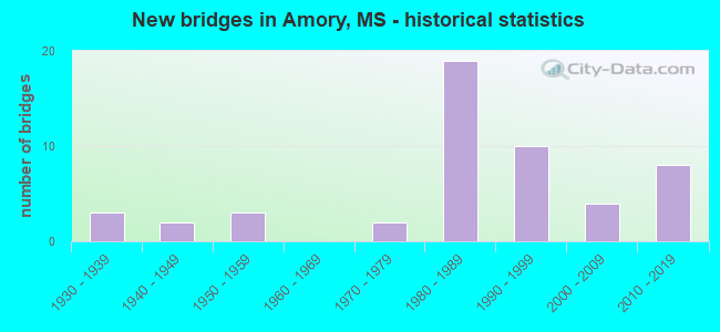
- New bridges - historical statistics
- 31930-1939
- 21940-1949
- 31950-1959
- 21970-1979
- 191980-1989
- 101990-1999
- 42000-2009
- 82010-2019
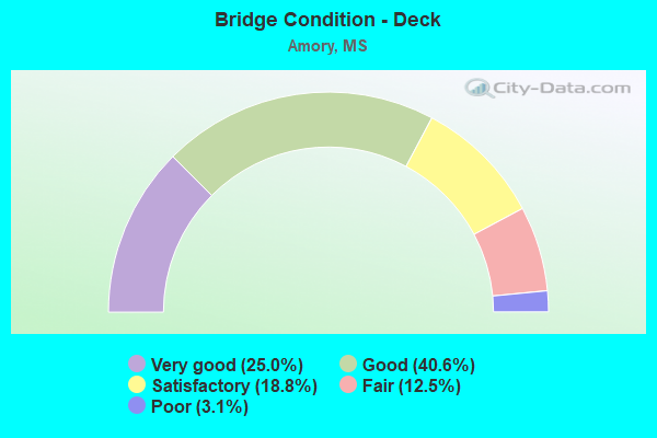
- Bridge Condition - Deck
- 25.0%Very good
- 40.6%Good
- 18.8%Satisfactory
- 12.5%Fair
- 3.1%Poor
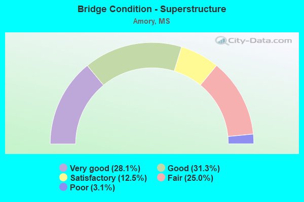
- Bridge Condition - Superstructure
- 28.1%Very good
- 31.3%Good
- 12.5%Satisfactory
- 25.0%Fair
- 3.1%Poor
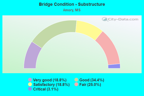
- Bridge Condition - Substructure
- 18.8%Very good
- 34.4%Good
- 18.8%Satisfactory
- 25.0%Fair
- 3.1%Critical
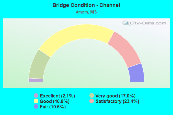
- Bridge Condition - Channel
- 2.1%Excellent
- 17.0%Very good
- 46.8%Good
- 23.4%Satisfactory
- 10.6%Fair
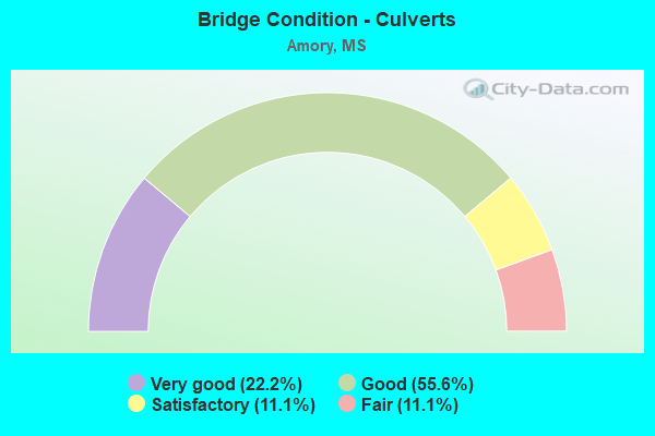
- Bridge Condition - Culverts
- 22.2%Very good
- 55.6%Good
- 11.1%Satisfactory
- 11.1%Fair
Find on map >> Show street view
Structure Number: SA4800000000195, Location: SEC 7 T13S R18W (Lat: 33.945519, Lng: -88.468164), Route carried "on" structure: County highway 171, Year Built: 2003, Status: Posted for load, Structure Length: 1.74m (5.71ft), Average Daily Traffic: 120 (year 2014), Truck Traffic: 5%, Average Future Daily Traffic: 180 (year 2034), Design Load: H 15, Features Intersected: UNNAMED SLOUGH, Facility Carried by Structure: OLD GOLF COURSE RD
Minimum Vertical Clearance: 30+ m (98+ ft), Kilometerpoint: 1.120, Lanes on structure: 2, Owner: County Highway Agency, Approaching Roadway Width: 8.1m (26.6ft), Material/Design: Concrete, Design/Construction: Channel Beam, Number Of Spans In Main Unit: 3, Length of Maximum Span: 5.8m (19.0ft), Curb or Sidewalk Widths: Left: 0.2m (0.7ft), Right: 0.2m (0.7ft), Curb-To-Curb Width: 8.1m (26.6ft), Out-to-Out Width: 8.5m (27.9ft)
Condition: Deck: Satisfactory, Superstructure: Poor, Substructure: Satisfactory, Channel: Good, Operating Rating: 17.6 metric tons, Method Used To Determine Operating Rating: Load Factor (LF), Inventory Rating: 10.4 metric tons, Method Used To Determine Inventory Rating: Load Factor (LF), Structural Evaluation: High priority of corrective action, Deck Geometry: Somewhat better than minimum adequacy, Waterway Adequacy: Equal to present desirable criteria, Approach Roadway Alignment: Equal to present desirable criteria, Bridge Posting: Required (Relationship of Operating Rating to Maximum Legal Load: > 39.9% below), Designated Inspection Frequency: Every 12 months, Inspection Date: April 2021, Deck Structure Type: Concrete Precast Panels, Wearing Surface/Protective System: Wearing Surface: Bituminous
Find on map >> Show street view
Structure Number: SA4800000000199, Location: SEC 30 T12S R 8E (Lat: 34.004806, Lng: -88.505556), Route carried "on" structure: County highway 6, Year Built: 1956, Status: Open, Structure Length: 5.49m (18.01ft), Average Daily Traffic: 100 (year 2014), Average Future Daily Traffic: 150 (year 2034), Design Load: H 15, Features Intersected: UNNAMED CREEK, Facility Carried by Structure: BLACKCAT BOTTOM
Minimum Vertical Clearance: 30+ m (98+ ft), Kilometerpoint: 0.000, Lanes on structure: 2, Owner: County Highway Agency, Approaching Roadway Width: 6.1m (20.0ft), Material/Design: Concrete, Design/Construction: Slab, Number Of Spans In Main Unit: 9, Length of Maximum Span: 6.1m (20.0ft), Curb or Sidewalk Widths: Left: 0.7m (2.3ft), Right: 0.7m (2.3ft), Curb-To-Curb Width: 7.9m (25.9ft), Out-to-Out Width: 9.3m (30.5ft)
Condition: Deck: Good, Superstructure: Good, Substructure: Good, Channel: Satisfactory, Operating Rating: 43.2 metric tons, Method Used To Determine Operating Rating: Load Factor (LF), Inventory Rating: 25.8 metric tons, Method Used To Determine Inventory Rating: Load Factor (LF), Structural Evaluation: Equal to present minimum criteria, Deck Geometry: Equal to present minimum criteria, Waterway Adequacy: Equal to present desirable criteria, Approach Roadway Alignment: Equal to present desirable criteria, Length Of Structure Improvement: 6.11m (20.05ft), Designated Inspection Frequency: Every 24 months, Inspection Date: March 2020, Bridge Improvement Cost: $364,000, Roadway Improvement Cost: $36,000, Total Project Cost: $448,000 ( Estimate for 2015), Deck Structure Type: Concrete Cast-file-Place, Wearing Surface/Protective System: Wearing Surface: Bituminous
Find on map >> Show street view
Structure Number: SA48000000002, Location: SEC 30 T12S R18W (Lat: 33.999444, Lng: -88.466389), Route carried "on" structure: County highway 175, Year Built: 2011, Status: Open, Structure Length: 1.08m (3.54ft), Average Daily Traffic: 450 (year 2014), Truck Traffic: 10%, Average Future Daily Traffic: 675 (year 2034), Design Load: HS 20, Features Intersected: BURKETTS CREEK, Facility Carried by Structure: PHILLIP SCHOUSE
Minimum Vertical Clearance: 30+ m (98+ ft), Kilometerpoint: 1.126, Lanes on structure: 2, Owner: County Highway Agency, Approaching Roadway Width: 9.1m (29.9ft), Skew: 1 degrees, Material/Design: Concrete, Design/Construction: Culvert, Number Of Spans In Main Unit: 2, Length of Maximum Span: 4.9m (16.1ft)
Condition: Channel: Very good, Culverts: Good, Operating Rating: 63.7 metric tons, Method Used To Determine Operating Rating: Load Factor (LF), Inventory Rating: 38.3 metric tons, Method Used To Determine Inventory Rating: Load Factor (LF), Structural Evaluation: Better than present minimum criteria, Waterway Adequacy: Equal to present desirable criteria, Approach Roadway Alignment: Equal to present desirable criteria, Designated Inspection Frequency: Every 24 months, Inspection Date: March 2020
Find on map >> Show street view
Structure Number: SA4800000000209, Location: SEC 19 T13S R18W (Lat: 33.920089, Lng: -88.477586), Route carried "on" structure: County highway 25, Year Built: 1949, Status: Open, Structure Length: 0.80m (2.62ft), Average Daily Traffic: 5,500 (year 2013), Truck Traffic: 8%, Average Future Daily Traffic: 9,900 (year 2036), Design Load: H 15, Features Intersected: GREENBRIAR BRANCH
Minimum Vertical Clearance: 30+ m (98+ ft), Kilometerpoint: 15.750, Lanes on structure: 2, Owner: County Highway Agency, Approaching Roadway Width: 8.0m (26.2ft), Material/Design: Concrete, Design/Construction: Culvert, Number Of Spans In Main Unit: 2, Length of Maximum Span: 4.0m (13.1ft)
Condition: Channel: Satisfactory, Culverts: Good, Operating Rating: 34.8 metric tons, Method Used To Determine Operating Rating: Load Factor (LF), Inventory Rating: 20.9 metric tons, Method Used To Determine Inventory Rating: Load Factor (LF), Structural Evaluation: Somewhat better than minimum adequacy, Waterway Adequacy: Equal to present desirable criteria, Approach Roadway Alignment: Equal to present desirable criteria, Designated Inspection Frequency: Every 24 months, Inspection Date: April 2021
Find on map >> Show street view
Structure Number: SA480000000021, Location: SEC 12 T13S R19W (Lat: 33.944319, Lng: -88.487522), Route carried "on" structure: County highway 25, Year Built: 1947, Status: Posted for load, Structure Length: 8.23m (27.00ft), Average Daily Traffic: 6,800 (year 2018), Truck Traffic: 8%, Average Future Daily Traffic: 10,100 (year 2038), Design Load: HS 20, Features Intersected: WEAVER CREEK
Minimum Vertical Clearance: 30+ m (98+ ft), Kilometerpoint: 28.207, Lanes on structure: 2, Owner: County Highway Agency, Approaching Roadway Width: 8.0m (26.2ft), Material/Design: Steel, Design/Construction: Stringer/Multi-beam, Number Of Spans In Main Unit: 9, Length of Maximum Span: 9.1m (29.9ft), Curb or Sidewalk Widths: Left: 1.6m (5.2ft), Right: 1.6m (5.2ft), Curb-To-Curb Width: 7.9m (25.9ft), Out-to-Out Width: 8.5m (27.9ft)
Condition: Deck: Fair, Superstructure: Fair, Substructure: Fair, Channel: Satisfactory, Operating Rating: 37.2 metric tons, Method Used To Determine Operating Rating: Load Factor (LF), Inventory Rating: 22.3 metric tons, Method Used To Determine Inventory Rating: Load Factor (LF), Structural Evaluation: Somewhat better than minimum adequacy, Deck Geometry: High priority of corrective action, Waterway Adequacy: Better than present minimum criteria, Approach Roadway Alignment: Equal to present minimum criteria, Designated Inspection Frequency: Every 12 months, Inspection Date: November 2021, Bridge Improvement Cost: $976,000, Roadway Improvement Cost: $98,000, Total Project Cost: $2,767,000, Deck Structure Type: Concrete Cast-file-Place, Wearing Surface/Protective System: Wearing Surface: Bituminous
Find on map >> Show street view
Structure Number: SA4800000000211, Location: SEC 34 T12S R19W (Lat: 33.972981, Lng: -88.504425), Route carried "on" structure: City street , Year Built: 2015, Status: Open, Structure Length: 2.38m (7.81ft), Average Daily Traffic: 100 (year 2020), Truck Traffic: 5%, Average Future Daily Traffic: 120 (year 2035), Design Load: HL 93, Features Intersected: UNNAMED CREEK, Facility Carried by Structure: FAIRWAYS DRIVE
Minimum Vertical Clearance: 30+ m (98+ ft), Kilometerpoint: 0.000, Lanes on structure: 2, Owner: Town or Township Highway Agency, Approaching Roadway Width: 6.7m (22.0ft), Skew: 3 degrees, Material/Design: Concrete, Design/Construction: Channel Beam, Number Of Spans In Main Unit: 3, Length of Maximum Span: 12.2m (40.0ft), Curb-To-Curb Width: 7.5m (24.6ft), Out-to-Out Width: 7.5m (24.6ft)
Condition: Deck: Very good, Superstructure: Good, Substructure: Good, Channel: Good, Operating Rating: 46.3 metric tons, Method Used To Determine Operating Rating: Load and Resistance Factor Rating (LRFR) rating reported by rating factor(RF) method using HL-93 loadings, Inventory Rating: 35.6 metric tons, Method Used To Determine Inventory Rating: Load and Resistance Factor Rating (LRFR) rating reported by rating factor(RF) method using HL-93 loadings, Structural Evaluation: Better than present minimum criteria, Deck Geometry: Equal to present minimum criteria, Waterway Adequacy: Equal to present desirable criteria, Approach Roadway Alignment: Equal to present desirable criteria, Designated Inspection Frequency: Every 24 months, Inspection Date: July 2020, Deck Structure Type: Concrete Precast Panels, Wearing Surface/Protective System: Wearing Surface: Bituminous
Find on map >> Show street view
Structure Number: SA480000000A18, Location: SEC 35 T12S R19W (Lat: 33.980356, Lng: -88.497489), Route carried "on" structure: City street 1209, Year Built: 2015, Status: Open, Structure Length: 0.94m (3.08ft), Average Daily Traffic: 200 (year 2022), Truck Traffic: 10%, Design Load: HS 20, Features Intersected: ROUNDHOUSE CK, Facility Carried by Structure: 109TH ST AMORY
Minimum Vertical Clearance: 30+ m (98+ ft), Kilometerpoint: 0.130, Lanes on structure: 2, Owner: City or Municipal Highway Agency, Approaching Roadway Width: 8.5m (27.9ft), Skew: 1 degrees, Material/Design: Concrete, Design/Construction: Culvert, Number Of Spans In Main Unit: 2, Length of Maximum Span: 4.3m (14.1ft)
Condition: Channel: Very good, Culverts: Good, Operating Rating: 66.0 metric tons, Method Used To Determine Operating Rating: Load Factor (LF), Inventory Rating: 39.6 metric tons, Method Used To Determine Inventory Rating: Load Factor (LF), Structural Evaluation: Better than present minimum criteria, Waterway Adequacy: Equal to present desirable criteria, Approach Roadway Alignment: Equal to present desirable criteria, Designated Inspection Frequency: Every 24 months, Inspection Date: Febuary 2022
Find on map >> Show street view
Structure Number: 21002780480081, Location: IN AMORY (Lat: 33.978989, Lng: -88.486119), Route carried "under" structure: US 278, Year Built: 1935, Structure Length: 0. m, Average Daily Traffic: 12,000 (year 2017), Truck Traffic: 8%, Features Intersected: US 278, Facility Carried by Structure: BURLINGTON N RR
Minimum Vertical Clearance: 4.19m (13.75ft), Kilometerpoint: 13.470, Lanes under structure: 2, Material/Design: Concrete, Design/Construction: Slab, Length of Maximum Span: 8.8m (28.9ft)