Bridge Statistics for Anderson, Indiana (IN)
Condition, Traffic, Stress, Structural Evaluation, Project Costs
- National Bridge Inventory (NBI) Statistics
- 96Number of bridges
- 1,207ft / 368mTotal length
- $4,040,000Total costs
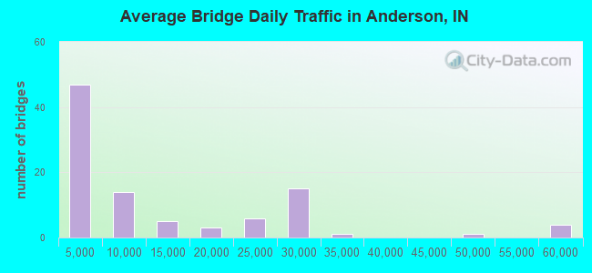
- 1,110,157Total average daily traffic
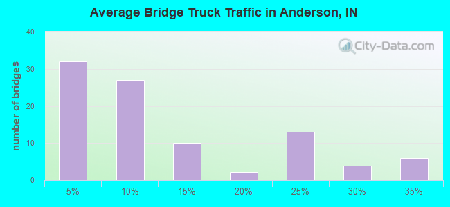
- 175,804Total average daily truck traffic
- National Bridge Inventory (NBI) Registered Bridges for Anderson
- No street view available for this location
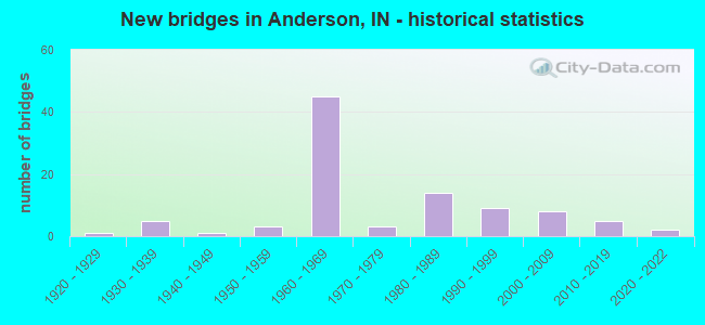
- New bridges - historical statistics
- 11920-1929
- 51930-1939
- 11940-1949
- 31950-1959
- 451960-1969
- 31970-1979
- 141980-1989
- 91990-1999
- 82000-2009
- 52010-2019
- 22020-2022
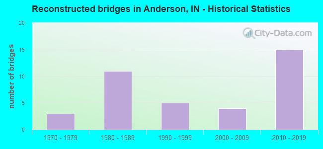
- Reconstructed bridges - Historical Statistics
- 31970-1979
- 111980-1989
- 51990-1999
- 42000-2009
- 152010-2019
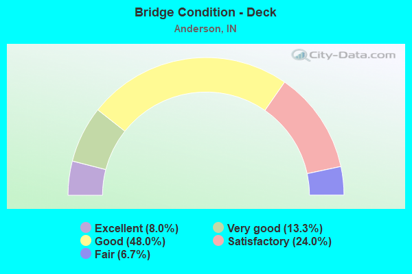
- Bridge Condition - Deck
- 8.0%Excellent
- 13.3%Very good
- 48.0%Good
- 24.0%Satisfactory
- 6.7%Fair
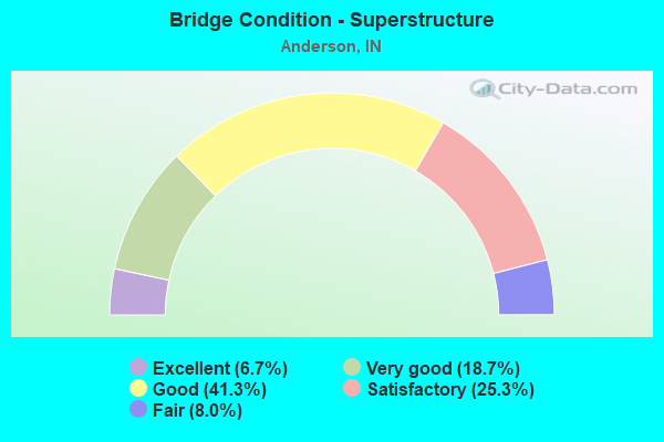
- Bridge Condition - Superstructure
- 6.7%Excellent
- 18.7%Very good
- 41.3%Good
- 25.3%Satisfactory
- 8.0%Fair

- Bridge Condition - Substructure
- 1.3%Excellent
- 9.3%Very good
- 65.3%Good
- 20.0%Satisfactory
- 4.0%Fair
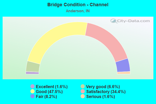
- Bridge Condition - Channel
- 1.6%Excellent
- 6.6%Very good
- 47.5%Good
- 34.4%Satisfactory
- 8.2%Fair
- 1.6%Serious
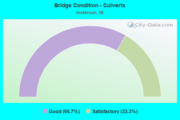
- Bridge Condition - Culverts
- 66.7%Good
- 33.3%Satisfactory
Find on map >> Show street view
Structure Number: 2415, Location: 02.65 N US 36 (Lat: 40.037819, Lng: -85.721861), Route carried "under" structure: Interstate 69, Year Built: 1962, Structure Length: 0. m, Average Daily Traffic: 25,990 (year 2006), Truck Traffic: 25%, Features Intersected: I-69 NB, Facility Carried by Structure: SR 9/SR 67
Minimum Vertical Clearance: 5.01m (16.44ft), Kilometerpoint: 36.017, Lanes on structure: 4, Lanes under structure: 2, Material/Design: Steel continuous, Design/Construction: Stringer/Multi-beam, Length of Maximum Span: 26.2m (86.0ft)
Find on map >> Show street view
Structure Number: 2415, Location: 02.65 N US 36 (Lat: 40.037819, Lng: -85.721861), Route carried "under" structure: Interstate 69, Year Built: 1962, Structure Length: 0. m, Average Daily Traffic: 25,990 (year 2006), Truck Traffic: 25%, Features Intersected: I-69 SB, Facility Carried by Structure: SR 9/SR 67
Minimum Vertical Clearance: 4.88m (16.01ft), Kilometerpoint: 36.017, Lanes on structure: 4, Lanes under structure: 2, Material/Design: Steel continuous, Design/Construction: Stringer/Multi-beam, Length of Maximum Span: 26.2m (86.0ft)
Find on map >> Show street view
Structure Number: 39101, Location: 02.19 N SR 38 (Lat: 40.030081, Lng: -85.748919), Route carried "under" structure: Interstate 69, Year Built: 2020, Structure Length: 0. m, Average Daily Traffic: 26,745 (year 2018), Truck Traffic: 21%, Features Intersected: I-69 NBL, Facility Carried by Structure: CR 400W
Minimum Vertical Clearance: 5.23m (17.16ft), Kilometerpoint: 355.424, Lanes on structure: 2, Lanes under structure: 6, Material/Design: Prestressed concrete continuous, Design/Construction: Tee Beam, Length of Maximum Span: 25.6m (84.0ft)
Find on map >> Show street view
Structure Number: 39101, Location: 02.19 N SR 38 (Lat: 40.030081, Lng: -85.748919), Route carried "under" structure: Interstate 69, Year Built: 2020, Structure Length: 0. m, Average Daily Traffic: 26,745 (year 2018), Truck Traffic: 21%, Features Intersected: I-69 SBL, Facility Carried by Structure: CR 400W
Minimum Vertical Clearance: 5.13m (16.83ft), Kilometerpoint: 355.424, Lanes on structure: 2, Lanes under structure: 6, Material/Design: Prestressed concrete continuous, Design/Construction: Tee Beam, Length of Maximum Span: 25.6m (84.0ft)
Find on map >> Show street view
Structure Number: 3915, Location: 01.67 N SR 67 (Lat: 40.046161, Lng: -85.692211), Route carried "under" structure: Interstate 69, Year Built: 1962, Structure Length: 0. m, Average Daily Traffic: 56,317 (year 2004), Truck Traffic: 15%, Features Intersected: I-69 NB, Facility Carried by Structure: BROWN ST RD/CR 100
Minimum Vertical Clearance: 4.90m (16.08ft), Kilometerpoint: 360.574, Lanes on structure: 2, Lanes under structure: 2, Material/Design: Prestressed concrete, Design/Construction: Box Beam or Girders - Multiple, Length of Maximum Span: 20.4m (66.9ft)
Find on map >> Show street view
Structure Number: 3915, Location: 01.67 N SR 67 (Lat: 40.046161, Lng: -85.692211), Route carried "under" structure: Interstate 69, Year Built: 1962, Structure Length: 0. m, Average Daily Traffic: 56,317 (year 2004), Truck Traffic: 15%, Features Intersected: I-69 SB, Facility Carried by Structure: BROWN ST RD/CR 100
Minimum Vertical Clearance: 4.88m (16.01ft), Kilometerpoint: 360.574, Lanes on structure: 2, Lanes under structure: 2, Material/Design: Prestressed concrete, Design/Construction: Box Beam or Girders - Multiple, Length of Maximum Span: 20.4m (66.9ft)
Find on map >> Show street view
Structure Number: 3916, Location: 01.33 S SR 9 (Lat: 40.050019, Lng: -85.677889), Route carried "under" structure: Interstate 69, Year Built: 1962, Structure Length: 0. m, Average Daily Traffic: 56,317 (year 2004), Truck Traffic: 10%, Features Intersected: I-69 NBL, Facility Carried by Structure: MAIN STREET
Minimum Vertical Clearance: 4.95m (16.24ft), Kilometerpoint: 361.877, Lanes on structure: 2, Lanes under structure: 4, Material/Design: Steel continuous, Design/Construction: Stringer/Multi-beam, Length of Maximum Span: 19.8m (65.0ft)
Find on map >> Show street view
Structure Number: 3916, Location: 01.33 S SR 9 (Lat: 40.050019, Lng: -85.677889), Route carried "under" structure: Interstate 69, Year Built: 1962, Structure Length: 0. m, Average Daily Traffic: 56,317 (year 2004), Truck Traffic: 1%, Features Intersected: I-69 SBL, Facility Carried by Structure: MAIN STREET
Minimum Vertical Clearance: 5.03m (16.50ft), Kilometerpoint: 361.877, Lanes on structure: 2, Lanes under structure: 4, Material/Design: Steel continuous, Design/Construction: Stringer/Multi-beam, Length of Maximum Span: 19.8m (65.0ft)
Find on map >> Show street view
Structure Number: 3917, Location: 00.60 S SR 9 (Lat: 40.051711, Lng: -85.664139), Route carried "under" structure: City street , Year Built: 1963, Structure Length: 0. m, Average Daily Traffic: 6,120 (year 2018), Truck Traffic: 10%, Features Intersected: OLD SR 109/COLUMBUS AV, Facility Carried by Structure: I-69 NB
Minimum Vertical Clearance: 4.40m (14.44ft), Kilometerpoint: 0.000, Lanes on structure: 3, Lanes under structure: 2, Material/Design: Steel continuous, Design/Construction: Stringer/Multi-beam, Length of Maximum Span: 12.6m (41.3ft)
Find on map >> Show street view
Structure Number: 3918, Location: 00.60 S SR 9 (Lat: 40.051961, Lng: -85.664211), Route carried "under" structure: City street , Year Built: 1963, Structure Length: 0. m, Average Daily Traffic: 6,120 (year 2018), Truck Traffic: 10%, Features Intersected: OLD SR 109/COLUMBUS AV, Facility Carried by Structure: I-69 SB
Minimum Vertical Clearance: 4.52m (14.83ft), Kilometerpoint: 0.000, Lanes on structure: 4, Lanes under structure: 2, Material/Design: Steel continuous, Design/Construction: Stringer/Multi-beam, Length of Maximum Span: 12.6m (41.3ft)
Find on map >> Show street view
Structure Number: 3921, Location: 03.35 S SR 236 (Lat: 40.053100, Lng: -85.652881), Route carried "under" structure: State highway 9, Year Built: 1963, Structure Length: 0. m, Average Daily Traffic: 8,660 (year 2018), Truck Traffic: 6%, Features Intersected: NB SR 9
Minimum Vertical Clearance: 5.08m (16.67ft), Kilometerpoint: 17.622, Lanes on structure: 3, Lanes under structure: 4, Material/Design: Steel continuous, Design/Construction: Stringer/Multi-beam, Length of Maximum Span: 13.5m (44.3ft)
Find on map >> Show street view
Structure Number: 3921, Location: 03.35 S SR 236 (Lat: 40.053100, Lng: -85.652881), Route carried "under" structure: State highway 9, Year Built: 1963, Structure Length: 0. m, Average Daily Traffic: 8,660 (year 2018), Truck Traffic: 6%, Features Intersected: SB SR 9
Minimum Vertical Clearance: 5.08m (16.67ft), Kilometerpoint: 17.622, Lanes on structure: 3, Lanes under structure: 4, Material/Design: Steel continuous, Design/Construction: Stringer/Multi-beam, Length of Maximum Span: 13.5m (44.3ft)
Find on map >> Show street view
Structure Number: 3922, Location: 03.35 S SR 236 (Lat: 40.053331, Lng: -85.652869), Route carried "under" structure: State highway 9, Year Built: 1963, Structure Length: 0. m, Average Daily Traffic: 8,660 (year 2018), Truck Traffic: 6%, Features Intersected: NB SR 9
Minimum Vertical Clearance: 5.08m (16.67ft), Kilometerpoint: 17.655, Lanes on structure: 3, Lanes under structure: 4, Material/Design: Steel continuous, Design/Construction: Stringer/Multi-beam, Length of Maximum Span: 13.5m (44.3ft)
Find on map >> Show street view
Structure Number: 3922, Location: 03.35 S SR 236 (Lat: 40.053331, Lng: -85.652869), Route carried "under" structure: State highway 9, Year Built: 1963, Structure Length: 0. m, Average Daily Traffic: 8,660 (year 2018), Truck Traffic: 6%, Features Intersected: SB SR 9
Minimum Vertical Clearance: 5.08m (16.67ft), Kilometerpoint: 17.655, Lanes on structure: 3, Lanes under structure: 4, Material/Design: Steel continuous, Design/Construction: Stringer/Multi-beam, Length of Maximum Span: 13.5m (44.3ft)
Find on map >> Show street view
Structure Number: 3923, Location: 01.03 N SR 9 (Lat: 40.055031, Lng: -85.633631), Route carried "under" structure: Interstate 69, Year Built: 1963, Structure Length: 0. m, Average Daily Traffic: 21,370 (year 2006), Truck Traffic: 31%, Features Intersected: I-69 NBL, Facility Carried by Structure: CR 200E
Minimum Vertical Clearance: 4.90m (16.08ft), Kilometerpoint: 365.675, Lanes on structure: 2, Lanes under structure: 4, Material/Design: Steel continuous, Design/Construction: Stringer/Multi-beam, Length of Maximum Span: 20.0m (65.6ft)
Find on map >> Show street view
Structure Number: 3923, Location: 01.03 N SR 9 (Lat: 40.055031, Lng: -85.633631), Route carried "under" structure: Interstate 69, Year Built: 1963, Structure Length: 0. m, Average Daily Traffic: 21,370 (year 2006), Truck Traffic: 31%, Features Intersected: I-69 SBL, Facility Carried by Structure: CR 200E
Minimum Vertical Clearance: 4.90m (16.08ft), Kilometerpoint: 365.675, Lanes on structure: 2, Lanes under structure: 4, Material/Design: Steel continuous, Design/Construction: Stringer/Multi-beam, Length of Maximum Span: 20.0m (65.6ft)
Find on map >> Show street view
Structure Number: 3924, Location: 02.04 N SR 9 (Lat: 40.055611, Lng: -85.614533), Route carried "under" structure: Interstate 69, Year Built: 1963, Structure Length: 0. m, Average Daily Traffic: 21,370 (year 2006), Truck Traffic: 31%, Features Intersected: I-69 NBL, Facility Carried by Structure: CR 300E
Minimum Vertical Clearance: 4.88m (16.01ft), Kilometerpoint: 367.301, Lanes on structure: 2, Lanes under structure: 4, Material/Design: Prestressed concrete, Design/Construction: Stringer/Multi-beam, Length of Maximum Span: 19.4m (63.6ft)
Find on map >> Show street view
Structure Number: 3924, Location: 02.04 N SR 9 (Lat: 40.055611, Lng: -85.614533), Route carried "under" structure: Interstate 69, Year Built: 1963, Structure Length: 0. m, Average Daily Traffic: 21,370 (year 2006), Truck Traffic: 31%, Features Intersected: I-69 SBL, Facility Carried by Structure: CR 300E
Minimum Vertical Clearance: 4.93m (16.17ft), Kilometerpoint: 367.301, Lanes on structure: 2, Lanes under structure: 4, Material/Design: Prestressed concrete, Design/Construction: Stringer/Multi-beam, Length of Maximum Span: 19.4m (63.6ft)