Bridge Statistics for Angola, Indiana (IN)
Condition, Traffic, Stress, Structural Evaluation, Project Costs
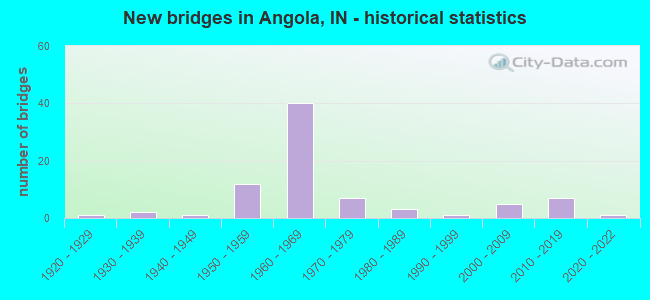
- New bridges - historical statistics
- 11920-1929
- 21930-1939
- 11940-1949
- 121950-1959
- 401960-1969
- 71970-1979
- 31980-1989
- 11990-1999
- 52000-2009
- 72010-2019
- 12020-2022
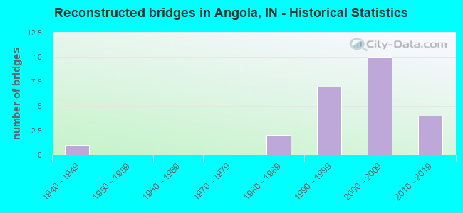
- Reconstructed bridges - Historical Statistics
- 11940-1949
- 01950-1959
- 01960-1969
- 01970-1979
- 21980-1989
- 71990-1999
- 102000-2009
- 42010-2019
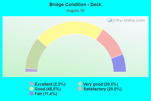
- Bridge Condition - Deck
- 2.3%Excellent
- 20.5%Very good
- 45.5%Good
- 20.5%Satisfactory
- 11.4%Fair
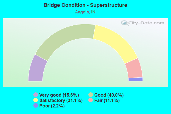
- Bridge Condition - Superstructure
- 15.6%Very good
- 40.0%Good
- 31.1%Satisfactory
- 11.1%Fair
- 2.2%Poor
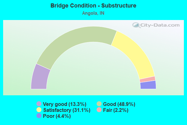
- Bridge Condition - Substructure
- 13.3%Very good
- 48.9%Good
- 31.1%Satisfactory
- 2.2%Fair
- 4.4%Poor
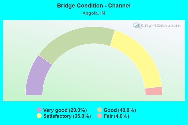
- Bridge Condition - Channel
- 20.0%Very good
- 40.0%Good
- 36.0%Satisfactory
- 4.0%Fair
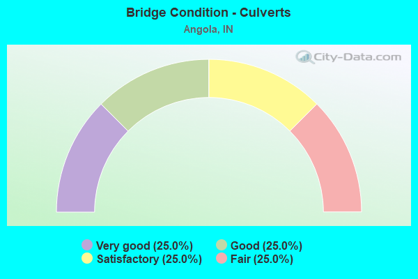
- Bridge Condition - Culverts
- 25.0%Very good
- 25.0%Good
- 25.0%Satisfactory
- 25.0%Fair
Find on map >> Show street view
Structure Number: 7600017, Location: 0.70 MILES N OF CR 400 S (Lat: 41.596389, Lng: -84.975531), Route carried "on" structure: Alternate City street , Year Built: 1974, Status: Open, Structure Length: 1.91m (6.27ft), Average Daily Traffic: 52 (year 2021), Average Future Daily Traffic: 73 (year 2041), Design Load: HS 20, Features Intersected: PIGEON CREEK, Facility Carried by Structure: S BILL DELLER Rd
Minimum Vertical Clearance: 30+ m (98+ ft), Kilometerpoint: 0.000, Lanes on structure: 2, Owner: County Highway Agency, Approaching Roadway Width: 7.0m (23.0ft), Material/Design: Concrete continuous, Design/Construction: Slab, Number Of Spans In Main Unit: 3, Length of Maximum Span: 7.3m (24.0ft), Curb-To-Curb Width: 8.4m (27.6ft), Out-to-Out Width: 8.5m (27.9ft)
Condition: Deck: Good, Superstructure: Good, Substructure: Good, Channel: Satisfactory, Operating Rating: 50.8 metric tons, Method Used To Determine Operating Rating: Load Factor (LF), Inventory Rating: 30.2 metric tons, Method Used To Determine Inventory Rating: Load Factor (LF), Structural Evaluation: Better than present minimum criteria, Deck Geometry: Equal to present minimum criteria, Waterway Adequacy: Better than present minimum criteria, Approach Roadway Alignment: Equal to present minimum criteria, Designated Inspection Frequency: Every 24 months, Inspection Date: October 2021, Deck Structure Type: Concrete Cast-file-Place, Wearing Surface/Protective System: Wearing Surface: Monolithic Concrete
Find on map >> Show street view
Structure Number: 7600028, Location: 0.10 MILES N OF CR 200 S (Lat: 41.613611, Lng: -85.076469), Route carried "on" structure: Alternate County highway 131, Year Built: 1975, Status: Posted for load, Structure Length: 1.83m (6.00ft), Average Daily Traffic: 56 (year 2021), Average Future Daily Traffic: 79 (year 2041), Design Load: HS 20, Features Intersected: PIGEON CREEK, Facility Carried by Structure: CR 450W
Minimum Vertical Clearance: 30+ m (98+ ft), Kilometerpoint: 0.000, Lanes on structure: 2, Owner: County Highway Agency, Approaching Roadway Width: 6.1m (20.0ft), Skew: 4 degrees, Material/Design: Prestressed concrete, Design/Construction: Box Beam or Girders - Multiple, Number Of Spans In Main Unit: 3, Length of Maximum Span: 7.3m (24.0ft), Curb-To-Curb Width: 8.4m (27.6ft), Out-to-Out Width: 8.6m (28.2ft)
Condition: Deck: Fair, Superstructure: Fair, Substructure: Satisfactory, Channel: Satisfactory, Operating Rating: 38.6 metric tons, Method Used To Determine Operating Rating: Load and Resistance Factor (LRFR), Inventory Rating: 31.2 metric tons, Method Used To Determine Inventory Rating: Load and Resistance Factor (LRFR), Structural Evaluation: Somewhat better than minimum adequacy, Deck Geometry: Equal to present minimum criteria, Waterway Adequacy: Equal to present minimum criteria, Approach Roadway Alignment: Equal to present minimum criteria, Designated Inspection Frequency: Every 24 months, Inspection Date: October 2021, Deck Structure Type: Concrete Precast Panels, Wearing Surface/Protective System: Wearing Surface: Bituminous
Find on map >> Show street view
Structure Number: 760003, Location: 0.30 MILES N OF US 20 (Lat: 41.646669, Lng: -85.160319), Route carried "on" structure: Alternate County highway 1, Year Built: 1966, Status: Open, Structure Length: 2.34m (7.68ft), Average Daily Traffic: 719 (year 2021), Truck Traffic: 3%, Average Future Daily Traffic: 1,004 (year 2041), Design Load: H 20, Features Intersected: PIGEON CREEK, Facility Carried by Structure: CR 900W
Minimum Vertical Clearance: 30+ m (98+ ft), Kilometerpoint: 0.000, Lanes on structure: 2, Owner: County Highway Agency, Approaching Roadway Width: 6.7m (22.0ft), Skew: 3 degrees, Material/Design: Prestressed concrete, Design/Construction: Stringer/Multi-beam, Number Of Spans In Main Unit: 1, Length of Maximum Span: 22.8m (74.8ft), Curb-To-Curb Width: 8.4m (27.6ft), Out-to-Out Width: 8.5m (27.9ft)
Condition: Deck: Good, Superstructure: Satisfactory, Substructure: Good, Channel: Good, Operating Rating: 58.0 metric tons, Method Used To Determine Operating Rating: Load Factor (LF), Inventory Rating: 34.7 metric tons, Method Used To Determine Inventory Rating: Load Factor (LF), Structural Evaluation: Equal to present minimum criteria, Deck Geometry: Somewhat better than minimum adequacy, Waterway Adequacy: Better than present minimum criteria, Approach Roadway Alignment: Equal to present desirable criteria, Designated Inspection Frequency: Every 24 months, Inspection Date: October 2021, Deck Structure Type: Concrete Cast-file-Place, Wearing Surface/Protective System: Wearing Surface: Bituminous
Find on map >> Show street view
Structure Number: 7600034, Location: 0.10 MILES E OF CREEK BAN (Lat: 41.638061, Lng: -85.112550), Route carried "on" structure: Alternate County highway 113, Year Built: 1975, Status: Open, Structure Length: 1.91m (6.27ft), Average Daily Traffic: 44 (year 2021), Average Future Daily Traffic: 62 (year 2041), Design Load: HS 20, Features Intersected: PIGEON CREEK, Facility Carried by Structure: CR 25S
Minimum Vertical Clearance: 30+ m (98+ ft), Kilometerpoint: 0.000, Lanes on structure: 2, Owner: County Highway Agency, Approaching Roadway Width: 6.7m (22.0ft), Skew: 1 degrees, Material/Design: Concrete continuous, Design/Construction: Slab, Number Of Spans In Main Unit: 3, Length of Maximum Span: 7.3m (24.0ft), Curb-To-Curb Width: 8.4m (27.6ft), Out-to-Out Width: 8.5m (27.9ft)
Condition: Deck: Good, Superstructure: Good, Substructure: Good, Channel: Satisfactory, Operating Rating: 50.8 metric tons, Method Used To Determine Operating Rating: Load Factor (LF), Inventory Rating: 30.2 metric tons, Method Used To Determine Inventory Rating: Load Factor (LF), Structural Evaluation: Better than present minimum criteria, Deck Geometry: Equal to present minimum criteria, Waterway Adequacy: Better than present minimum criteria, Approach Roadway Alignment: Equal to present desirable criteria, Designated Inspection Frequency: Every 24 months, Inspection Date: October 2021, Deck Structure Type: Concrete Cast-file-Place, Wearing Surface/Protective System: Wearing Surface: Monolithic Concrete
Find on map >> Show street view
Structure Number: 7600037, Location: 0.10 MILES S OF CR 400 N (Lat: 41.699439, Lng: -85.048231), Route carried "on" structure: Alternate County highway 29, Year Built: 2002, Status: Open, Structure Length: 1.30m (4.27ft), Average Daily Traffic: 2,816 (year 2021), Truck Traffic: 6%, Average Future Daily Traffic: 3,929 (year 2041), Design Load: HS 20, Features Intersected: CHANNEL AT LAKE JAMES, Facility Carried by Structure: CR 300W
Minimum Vertical Clearance: 30+ m (98+ ft), Kilometerpoint: 0.000, Lanes on structure: 2, Owner: County Highway Agency, Approaching Roadway Width: 7.3m (24.0ft), Material/Design: Prestressed concrete, Design/Construction: Box Beam or Girders - Multiple, Number Of Spans In Main Unit: 1, Length of Maximum Span: 12.2m (40.0ft), Curb or Sidewalk Widths: Left: 1.5m (4.9ft), Right: 1.6m (5.2ft), Curb-To-Curb Width: 7.3m (24.0ft), Out-to-Out Width: 11.4m (37.4ft)
Condition: Deck: Good, Superstructure: Satisfactory, Substructure: Very good, Channel: Good, Operating Rating: 68.0 metric tons, Method Used To Determine Operating Rating: Load Factor (LF), Inventory Rating: 28.7 metric tons, Method Used To Determine Inventory Rating: Load Factor (LF), Structural Evaluation: Equal to present minimum criteria, Deck Geometry: High priority of replacement, Waterway Adequacy: Equal to present desirable criteria, Approach Roadway Alignment: Equal to present desirable criteria, Designated Inspection Frequency: Every 24 months, Inspection Date: October 2021, Deck Structure Type: Concrete Cast-file-Place, Wearing Surface/Protective System: Wearing Surface: Monolithic Concrete, Deck Protection: Epoxy Coated Reinforcing
Find on map >> Show street view
Structure Number: 7600043, Location: 0.30 MILES N OF EDUNHAM R (Lat: 41.645211, Lng: -84.840989), Route carried "on" structure: County highway 1, Year Built: 1967, Status: Open, Structure Length: 0.91m (2.99ft), Average Daily Traffic: 241 (year 2021), Truck Traffic: 5%, Average Future Daily Traffic: 337 (year 2041), Design Load: H 20, Features Intersected: G POWERS/WEST BRANCH
Minimum Vertical Clearance: 30+ m (98+ ft), Kilometerpoint: 0.000, Lanes on structure: 2, Owner: County Highway Agency, Approaching Roadway Width: 6.4m (21.0ft), Material/Design: Prestressed concrete, Design/Construction: Box Beam or Girders - Multiple, Number Of Spans In Main Unit: 1, Length of Maximum Span: 8.8m (28.9ft), Curb-To-Curb Width: 10.9m (35.8ft), Out-to-Out Width: 11.5m (37.7ft)
Condition: Deck: Satisfactory, Superstructure: Satisfactory, Substructure: Poor, Channel: Satisfactory, Operating Rating: 59.9 metric tons, Method Used To Determine Operating Rating: Load Factor (LF), Inventory Rating: 35.5 metric tons, Method Used To Determine Inventory Rating: Load Factor (LF), Structural Evaluation: Meets minimum limits, Deck Geometry: Better than present minimum criteria, Waterway Adequacy: Somewhat better than minimum adequacy, Approach Roadway Alignment: Equal to present desirable criteria, Designated Inspection Frequency: Every 12 months, Inspection Date: October 2021, Deck Structure Type: Concrete Precast Panels, Wearing Surface/Protective System: Wearing Surface: Bituminous
Find on map >> Show street view
Structure Number: 7600044, Location: 0.60 MILES S OF CR 400 S (Lat: 41.576939, Lng: -85.008611), Route carried "on" structure: County highway 27, Year Built: 1927, Year Reconstructed: 1994, Status: Open, Structure Length: 1.25m (4.10ft), Average Daily Traffic: 5,462 (year 2021), Truck Traffic: 6%, Average Future Daily Traffic: 7,620 (year 2041), Design Load: HS 20, Features Intersected: PIGEON CREEK
Minimum Vertical Clearance: 30+ m (98+ ft), Kilometerpoint: 0.000, Lanes on structure: 2, Owner: County Highway Agency, Approaching Roadway Width: 10.4m (34.1ft), Material/Design: Prestressed concrete, Design/Construction: Box Beam or Girders - Multiple, Number Of Spans In Main Unit: 1, Length of Maximum Span: 12.2m (40.0ft), Curb-To-Curb Width: 10.5m (34.4ft), Out-to-Out Width: 11.4m (37.4ft)
Condition: Deck: Good, Superstructure: Good, Substructure: Satisfactory, Channel: Good, Operating Rating: 59.9 metric tons, Method Used To Determine Operating Rating: Load Factor (LF), Inventory Rating: 35.4 metric tons, Method Used To Determine Inventory Rating: Load Factor (LF), Structural Evaluation: Equal to present minimum criteria, Deck Geometry: Meets minimum limits, Waterway Adequacy: Better than present minimum criteria, Approach Roadway Alignment: Equal to present desirable criteria, Designated Inspection Frequency: Every 24 months, Inspection Date: October 2021, Deck Structure Type: Concrete Cast-file-Place, Wearing Surface/Protective System: Wearing Surface: Monolithic Concrete, Deck Protection: Epoxy Coated Reinforcing
Find on map >> Show street view
Structure Number: 7600047, Location: 0.50 MILES W OF OLD SR 27 (Lat: 41.624161, Lng: -85.009289), Route carried "on" structure: Alternate City street , Year Built: 1978, Status: Open, Structure Length: 3.19m (10.47ft), Average Daily Traffic: 695 (year 2021), Truck Traffic: 3%, Average Future Daily Traffic: 970 (year 2041), Design Load: HS 20, Features Intersected: INDIANA NORTHEASTERN RR, Facility Carried by Structure: FOX LAKE RD
Minimum Vertical Clearance: 30+ m (98+ ft), Kilometerpoint: 0.000, Lanes on structure: 2, Owner: County Highway Agency, Approaching Roadway Width: 6.1m (20.0ft), Material/Design: Concrete continuous, Design/Construction: Slab, Number Of Spans In Main Unit: 3, Length of Maximum Span: 10.4m (34.1ft), Curb-To-Curb Width: 8.5m (27.9ft), Out-to-Out Width: 9.4m (30.8ft)
Condition: Deck: Good, Superstructure: Satisfactory, Substructure: Satisfactory, Operating Rating: 63.5 metric tons, Method Used To Determine Operating Rating: Load Factor (LF), Inventory Rating: 37.6 metric tons, Method Used To Determine Inventory Rating: Load Factor (LF), Structural Evaluation: Equal to present minimum criteria, Deck Geometry: Somewhat better than minimum adequacy, Underclear: Somewhat better than minimum adequacy, Approach Roadway Alignment: Equal to present desirable criteria, Designated Inspection Frequency: Every 24 months, Inspection Date: October 2021, Deck Structure Type: Concrete Cast-file-Place, Wearing Surface/Protective System: Wearing Surface: Bituminous
Find on map >> Show street view
Structure Number: 7600053, Location: 0.80 MILES S OF CR 300 N (Lat: 41.673339, Lng: -85.067281), Route carried "on" structure: Alternate County highway 141, Year Built: 1982, Status: Open, Structure Length: 0.79m (2.59ft), Average Daily Traffic: 1,052 (year 2021), Truck Traffic: 3%, Average Future Daily Traffic: 1,468 (year 2041), Design Load: HS 20, Features Intersected: CHANNEL of CROOKED LAKE, Facility Carried by Structure: CR 400W
Minimum Vertical Clearance: 30+ m (98+ ft), Kilometerpoint: 0.000, Lanes on structure: 2, Owner: County Highway Agency, Approaching Roadway Width: 6.4m (21.0ft), Material/Design: Prestressed concrete, Design/Construction: Box Beam or Girders - Multiple, Number Of Spans In Main Unit: 1, Length of Maximum Span: 7.6m (24.9ft), Curb-To-Curb Width: 8.5m (27.9ft), Out-to-Out Width: 8.6m (28.2ft)
Condition: Deck: Satisfactory, Superstructure: Satisfactory, Substructure: Satisfactory, Channel: Satisfactory, Operating Rating: 67.1 metric tons, Method Used To Determine Operating Rating: Load Factor (LF), Inventory Rating: 40.0 metric tons, Method Used To Determine Inventory Rating: Load Factor (LF), Structural Evaluation: Equal to present minimum criteria, Deck Geometry: Somewhat better than minimum adequacy, Waterway Adequacy: Superior to present desirable criteria, Approach Roadway Alignment: Equal to present desirable criteria, Designated Inspection Frequency: Every 24 months, Inspection Date: October 2021, Deck Structure Type: Concrete Precast Panels, Wearing Surface/Protective System: Wearing Surface: Bituminous
Find on map >> Show street view
Structure Number: 7600061, Location: 0.30 MILES W OF CR 275 E (Lat: 41.604439, Lng: -84.942481), Route carried "on" structure: Alternate County highway , Year Built: 2021, Status: Open, Structure Length: 2.10m (6.89ft), Average Daily Traffic: 351 (year 2021), Truck Traffic: 3%, Average Future Daily Traffic: 490 (year 2041), Design Load: HL 93, Features Intersected: PIGEON CREEK, Facility Carried by Structure: HANSELMAN Rd
Minimum Vertical Clearance: 30+ m (98+ ft), Kilometerpoint: 0.000, Lanes on structure: 2, Owner: County Highway Agency, Approaching Roadway Width: 8.5m (27.9ft), Material/Design: Prestressed concrete, Design/Construction: Box Beam or Girders - Multiple, Number Of Spans In Main Unit: 1, Length of Maximum Span: 20.5m (67.3ft), Curb-To-Curb Width: 8.6m (28.2ft), Out-to-Out Width: 8.6m (28.2ft)
Condition: Deck: Very good, Superstructure: Very good, Substructure: Very good, Channel: Very good, Operating Rating: 61.9 metric tons, Method Used To Determine Operating Rating: Load and Resistance Factor Rating (LRFR) rating reported by rating factor(RF) method using HL-93 loadings, Inventory Rating: 47.6 metric tons, Method Used To Determine Inventory Rating: Load and Resistance Factor Rating (LRFR) rating reported by rating factor(RF) method using HL-93 loadings, Structural Evaluation: Equal to present desirable criteria, Deck Geometry: Equal to present minimum criteria, Waterway Adequacy: Equal to present desirable criteria, Approach Roadway Alignment: Equal to present desirable criteria, Designated Inspection Frequency: Every 24 months, Inspection Date: October 2021, Deck Structure Type: Concrete Precast Panels, Wearing Surface/Protective System: Wearing Surface: Bituminous, Membrane: Preformed Fabric
Find on map >> Show street view
Structure Number: 2592, Location: 00.07 E SR 127 (Lat: 41.729800, Lng: -85.000275), Route carried "under" structure: Interstate 69, Year Built: 1965, Structure Length: 0. m, Average Daily Traffic: 8,994 (year 2021), Truck Traffic: 34%, Features Intersected: I-69 NB, Facility Carried by Structure: SR 120
Minimum Vertical Clearance: 5.03m (16.50ft), Kilometerpoint: 249.802, Lanes on structure: 2, Lanes under structure: 3, Material/Design: Steel continuous, Design/Construction: Stringer/Multi-beam, Length of Maximum Span: 21.6m (70.9ft)
Find on map >> Show street view
Structure Number: 2592, Location: 00.07 E SR 127 (Lat: 41.729800, Lng: -85.000275), Route carried "under" structure: Interstate 69, Year Built: 1965, Structure Length: 0. m, Average Daily Traffic: 8,994 (year 2021), Truck Traffic: 34%, Features Intersected: I-69 SB, Facility Carried by Structure: SR 120
Minimum Vertical Clearance: 5.03m (16.50ft), Kilometerpoint: 249.802, Lanes on structure: 2, Lanes under structure: 3, Material/Design: Steel continuous, Design/Construction: Stringer/Multi-beam, Length of Maximum Span: 21.6m (70.9ft)
Find on map >> Show street view
Structure Number: 4079, Location: 02.95 S US 20 (Lat: 41.594389, Lng: -85.053986), Route carried "under" structure: Interstate 69, Year Built: 1963, Structure Length: 0. m, Average Daily Traffic: 9,899 (year 2020), Truck Traffic: 29%, Features Intersected: I-69 NB, Facility Carried by Structure: CR 325W
Minimum Vertical Clearance: 5.01m (16.44ft), Kilometerpoint: 554.451, Lanes on structure: 2, Lanes under structure: 4, Material/Design: Steel continuous, Design/Construction: Stringer/Multi-beam, Length of Maximum Span: 20.1m (65.9ft)
Find on map >> Show street view
Structure Number: 4079, Location: 02.95 S US 20 (Lat: 41.594389, Lng: -85.053986), Route carried "under" structure: Interstate 69, Year Built: 1963, Structure Length: 0. m, Average Daily Traffic: 9,899 (year 2020), Truck Traffic: 29%, Features Intersected: I-69 SB, Facility Carried by Structure: CR 325W
Minimum Vertical Clearance: 5.03m (16.50ft), Kilometerpoint: 554.451, Lanes on structure: 2, Lanes under structure: 4, Material/Design: Steel continuous, Design/Construction: Stringer/Multi-beam, Length of Maximum Span: 20.1m (65.9ft)
Find on map >> Show street view
Structure Number: 4082, Location: 01.80 S US 20 (Lat: 41.609161, Lng: -85.046867), Route carried "under" structure: County highway , Year Built: 1963, Structure Length: 0. m, Average Daily Traffic: 384 (year 2019), Truck Traffic: 13%, Features Intersected: FOX LAKE RD, Facility Carried by Structure: I-69 NB
Minimum Vertical Clearance: 4.34m (14.24ft), Kilometerpoint: 0.000, Lanes on structure: 2, Lanes under structure: 2, Material/Design: Concrete continuous, Design/Construction: Slab, Length of Maximum Span: 12.2m (40.0ft)
Find on map >> Show street view
Structure Number: 4083, Location: 01.80 S US 20 (Lat: 41.609161, Lng: -85.047194), Route carried "under" structure: County highway , Year Built: 1963, Structure Length: 0. m, Average Daily Traffic: 384 (year 2019), Truck Traffic: 13%, Features Intersected: FOX LAKE RD, Facility Carried by Structure: I-69 SB
Minimum Vertical Clearance: 4.47m (14.67ft), Kilometerpoint: 0.000, Lanes on structure: 2, Lanes under structure: 2, Material/Design: Concrete continuous, Design/Construction: Slab, Length of Maximum Span: 12.2m (40.0ft)
Find on map >> Show street view
Structure Number: 4084, Location: 01.62 N US 20 (Lat: 41.656900, Lng: -85.040153), Route carried "under" structure: Interstate 69, Year Built: 1963, Structure Length: 0. m, Average Daily Traffic: 10,204 (year 2020), Truck Traffic: 28%, Features Intersected: I-69 NB, Facility Carried by Structure: CR 100N
Minimum Vertical Clearance: 4.90m (16.08ft), Kilometerpoint: 561.806, Lanes on structure: 2, Lanes under structure: 4, Material/Design: Prestressed concrete, Design/Construction: Stringer/Multi-beam, Length of Maximum Span: 21.1m (69.2ft)
Find on map >> Show street view
Structure Number: 4084, Location: 01.62 N US 20 (Lat: 41.656900, Lng: -85.040153), Route carried "under" structure: Interstate 69, Year Built: 1963, Structure Length: 0. m, Average Daily Traffic: 9,831 (year 2020), Truck Traffic: 28%, Features Intersected: I-69 SB, Facility Carried by Structure: CR 100N
Minimum Vertical Clearance: 4.90m (16.08ft), Kilometerpoint: 561.806, Lanes on structure: 2, Lanes under structure: 4, Material/Design: Prestressed concrete, Design/Construction: Stringer/Multi-beam, Length of Maximum Span: 21.1m (69.2ft)
Find on map >> Show street view
Structure Number: 4085, Location: 02.43 N US 20 (Lat: 41.664089, Lng: -85.028436), Route carried "under" structure: County highway , Year Built: 1965, Structure Length: 0. m, Average Daily Traffic: 2,479 (year 2020), Truck Traffic: 5%, Features Intersected: NB CR 200W, Facility Carried by Structure: I-69 NB
Minimum Vertical Clearance: 4.37m (14.34ft), Kilometerpoint: 0.000, Lanes on structure: 2, Lanes under structure: 2, Material/Design: Steel continuous, Design/Construction: Stringer/Multi-beam, Length of Maximum Span: 12.9m (42.3ft)
Find on map >> Show street view
Structure Number: 4085, Location: 02.43 N US 20 (Lat: 41.664089, Lng: -85.028436), Route carried "under" structure: County highway , Year Built: 1965, Structure Length: 0. m, Average Daily Traffic: 2,479 (year 2020), Truck Traffic: 5%, Features Intersected: SB CR 200W, Facility Carried by Structure: I-69 SB
Minimum Vertical Clearance: 4.40m (14.44ft), Kilometerpoint: 0.000, Lanes on structure: 2, Lanes under structure: 2, Material/Design: Steel continuous, Design/Construction: Stringer/Multi-beam, Length of Maximum Span: 12.9m (42.3ft)
Find on map >> Show street view
Structure Number: 4086, Location: 02.43 N US 20 (Lat: 41.664331, Lng: -85.028442), Route carried "under" structure: County highway , Year Built: 1965, Structure Length: 0. m, Average Daily Traffic: 2,479 (year 2020), Truck Traffic: 5%, Features Intersected: NB CR 200W, Facility Carried by Structure: I-69 SB
Minimum Vertical Clearance: 4.50m (14.76ft), Kilometerpoint: 0.000, Lanes on structure: 2, Lanes under structure: 4, Material/Design: Steel continuous, Design/Construction: Stringer/Multi-beam, Length of Maximum Span: 12.9m (42.3ft)
Find on map >> Show street view
Structure Number: 4086, Location: 02.43 N US 20 (Lat: 41.664331, Lng: -85.028442), Route carried "under" structure: County highway , Year Built: 1965, Structure Length: 0. m, Average Daily Traffic: 2,479 (year 2020), Truck Traffic: 5%, Features Intersected: SB CR 200W, Facility Carried by Structure: I-69 SB
Minimum Vertical Clearance: 4.50m (14.76ft), Kilometerpoint: 0.000, Lanes on structure: 2, Lanes under structure: 4, Material/Design: Steel continuous, Design/Construction: Stringer/Multi-beam, Length of Maximum Span: 12.9m (42.3ft)
Find on map >> Show street view
Structure Number: 4087, Location: 02.52 S SR-127 (Lat: 41.671381, Lng: -85.009864), Route carried "under" structure: Interstate 69, Year Built: 1964, Structure Length: 0. m, Average Daily Traffic: 7,910 (year 2020), Truck Traffic: 34%, Features Intersected: I-69 NB, Facility Carried by Structure: CR 200N
Minimum Vertical Clearance: 5.08m (16.67ft), Kilometerpoint: 564.896, Lanes on structure: 2, Lanes under structure: 4, Material/Design: Prestressed concrete, Design/Construction: Stringer/Multi-beam, Length of Maximum Span: 21.1m (69.2ft)
Find on map >> Show street view
Structure Number: 4087, Location: 02.52 S SR-127 (Lat: 41.671381, Lng: -85.009864), Route carried "under" structure: Interstate 69, Year Built: 1964, Structure Length: 0. m, Average Daily Traffic: 8,317 (year 2020), Truck Traffic: 34%, Features Intersected: I-69 SB, Facility Carried by Structure: CR 200N
Minimum Vertical Clearance: 5.03m (16.50ft), Kilometerpoint: 564.896, Lanes on structure: 2, Lanes under structure: 4, Material/Design: Prestressed concrete, Design/Construction: Stringer/Multi-beam, Length of Maximum Span: 21.1m (69.2ft)
Find on map >> Show street view
Structure Number: 4088, Location: 01.65 S SR 127 (Lat: 41.682700, Lng: -85.003953), Route carried "under" structure: Interstate 69, Year Built: 1964, Structure Length: 0. m, Average Daily Traffic: 7,910 (year 2020), Truck Traffic: 34%, Features Intersected: I-69 NB, Facility Carried by Structure: CR 275N
Minimum Vertical Clearance: 5.41m (17.75ft), Kilometerpoint: 566.312, Lanes on structure: 2, Lanes under structure: 2, Material/Design: Prestressed concrete continuous, Design/Construction: Stringer/Multi-beam, Length of Maximum Span: 19.1m (62.7ft)
Find on map >> Show street view
Structure Number: 4088, Location: 01.65 S SR 127 (Lat: 41.682700, Lng: -85.003953), Route carried "under" structure: Interstate 69, Year Built: 1964, Structure Length: 0. m, Average Daily Traffic: 8,317 (year 2020), Truck Traffic: 34%, Features Intersected: I-69 SB, Facility Carried by Structure: CR 275N
Minimum Vertical Clearance: 5.41m (17.75ft), Kilometerpoint: 566.312, Lanes on structure: 2, Lanes under structure: 2, Material/Design: Prestressed concrete continuous, Design/Construction: Stringer/Multi-beam, Length of Maximum Span: 19.1m (62.7ft)
Find on map >> Show street view
Structure Number: 4091, Location: 00.37 S SR 127 (Lat: 41.701061, Lng: -85.004403), Route carried "under" structure: Interstate 69, Year Built: 1966, Structure Length: 0. m, Average Daily Traffic: 8,317 (year 2020), Truck Traffic: 34%, Features Intersected: I-69 SB & RAMP, Facility Carried by Structure: CR 400N
Minimum Vertical Clearance: 5.23m (17.16ft), Kilometerpoint: 568.372, Lanes on structure: 2, Lanes under structure: 6, Material/Design: Steel continuous, Design/Construction: Stringer/Multi-beam, Length of Maximum Span: 35.9m (117.8ft)
Find on map >> Show street view
Structure Number: 4091, Location: 00.37 S SR 127 (Lat: 41.701061, Lng: -85.004403), Route carried "under" structure: Interstate 69, Year Built: 1966, Structure Length: 0. m, Average Daily Traffic: 7,910 (year 2020), Truck Traffic: 34%, Features Intersected: I-69 NB & RAMP, Facility Carried by Structure: CR 400N
Minimum Vertical Clearance: 5.33m (17.49ft), Kilometerpoint: 568.372, Lanes on structure: 2, Lanes under structure: 6, Material/Design: Steel continuous, Design/Construction: Stringer/Multi-beam, Length of Maximum Span: 35.9m (117.8ft)
Find on map >> Show street view
Structure Number: 4092, Location: 01.68 S SR-120 (Lat: 41.706328, Lng: -85.004689), Route carried "under" structure: State highway 127, Year Built: 1965, Structure Length: 0. m, Average Daily Traffic: 4,487 (year 2019), Truck Traffic: 5%, Features Intersected: SR 127, Facility Carried by Structure: I-69 NB
Minimum Vertical Clearance: 4.85m (15.91ft), Kilometerpoint: 8.095, Lanes on structure: 2, Lanes under structure: 2, Material/Design: Steel continuous, Design/Construction: Stringer/Multi-beam, Length of Maximum Span: 14.3m (46.9ft)
Find on map >> Show street view
Structure Number: 4093, Location: 01.68 S SR-120 (Lat: 41.706361, Lng: -85.005019), Route carried "under" structure: State highway 127, Year Built: 1965, Structure Length: 0. m, Average Daily Traffic: 4,487 (year 2019), Truck Traffic: 5%, Features Intersected: SR 127, Facility Carried by Structure: I-69 SB
Minimum Vertical Clearance: 4.80m (15.75ft), Kilometerpoint: 8.127, Lanes on structure: 2, Lanes under structure: 2, Material/Design: Steel continuous, Design/Construction: Stringer/Multi-beam, Length of Maximum Span: 14.3m (46.9ft)
Find on map >> Show street view
Structure Number: 4892, Location: 02.51 W US 20 (Lat: 41.659019, Lng: -84.844603), Route carried "under" structure: County highway , Year Built: 1956, Structure Length: 0. m, Average Daily Traffic: 301 (year 2004), Truck Traffic: 10%, Features Intersected: CR 100N, Facility Carried by Structure: I-90 WB
Minimum Vertical Clearance: 4.65m (15.26ft), Kilometerpoint: 0.000, Lanes on structure: 2, Lanes under structure: 2, Toll: On toll road, Material/Design: Prestressed concrete continuous, Design/Construction: Stringer/Multi-beam, Length of Maximum Span: 12.0m (39.4ft)
Find on map >> Show street view
Structure Number: 4895, Location: 00.84 W US 20 (Lat: 41.639450, Lng: -84.829383), Route carried "under" structure: Interstate 90, Year Built: 1956, Structure Length: 0. m, Average Daily Traffic: 10,240 (year 2015), Truck Traffic: 24%, Features Intersected: I-90 WB, Facility Carried by Structure: CR 40S
Minimum Vertical Clearance: 4.65m (15.26ft), Kilometerpoint: 249.963, Lanes on structure: 2, Lanes under structure: 2, Toll: On toll road, Material/Design: Steel, Design/Construction: Stringer/Multi-beam, Length of Maximum Span: 28.0m (91.9ft)
Find on map >> Show street view
Structure Number: 4895, Location: 00.84 W US 20 (Lat: 41.639450, Lng: -84.829383), Route carried "under" structure: Interstate 90, Year Built: 1956, Structure Length: 0. m, Average Daily Traffic: 10,240 (year 2015), Truck Traffic: 24%, Features Intersected: I-90 EB, Facility Carried by Structure: CR 40S
Minimum Vertical Clearance: 4.65m (15.26ft), Kilometerpoint: 249.963, Lanes on structure: 2, Lanes under structure: 2, Toll: On toll road, Material/Design: Steel, Design/Construction: Stringer/Multi-beam, Length of Maximum Span: 28.0m (91.9ft)
Find on map >> Show street view
Structure Number: 4898, Location: 08.67 E SR 827 (Lat: 41.630600, Lng: -84.817992), Route carried "under" structure: US 20, Year Built: 1956, Structure Length: 0. m, Average Daily Traffic: 3,134 (year 2015), Truck Traffic: 10%, Features Intersected: US 20, Facility Carried by Structure: I-90 WB
Minimum Vertical Clearance: 4.93m (16.17ft), Kilometerpoint: 32.300, Lanes on structure: 2, Lanes under structure: 2, Material/Design: Prestressed concrete continuous, Design/Construction: Stringer/Multi-beam, Length of Maximum Span: 18.2m (59.7ft)
Find on map >> Show street view
Structure Number: 4899, Location: 00.32 E US 20 (Lat: 41.628331, Lng: -84.812972), Route carried "under" structure: Interstate 90, Year Built: 1956, Structure Length: 0. m, Average Daily Traffic: 10,460 (year 2014), Truck Traffic: 24%, Features Intersected: I-90 EB, Facility Carried by Structure: CR 935E
Minimum Vertical Clearance: 4.93m (16.17ft), Kilometerpoint: 251.830, Lanes on structure: 2, Lanes under structure: 2, Toll: On toll road, Material/Design: Steel, Design/Construction: Stringer/Multi-beam, Length of Maximum Span: 20.5m (67.3ft)
Find on map >> Show street view
Structure Number: 4899, Location: 00.32 E US 20 (Lat: 41.628331, Lng: -84.812972), Route carried "under" structure: Interstate 90, Year Built: 1956, Structure Length: 0. m, Average Daily Traffic: 10,460 (year 2014), Truck Traffic: 24%, Features Intersected: I-90 WB, Facility Carried by Structure: CR 935E
Minimum Vertical Clearance: 4.93m (16.17ft), Kilometerpoint: 251.830, Lanes on structure: 2, Lanes under structure: 2, Toll: On toll road, Material/Design: Steel, Design/Construction: Stringer/Multi-beam, Length of Maximum Span: 20.5m (67.3ft)
Find on map >> Show street view
Structure Number: 60065, Location: 00.00 POKAGON STATE PARK (Lat: 41.707869, Lng: -85.032333), Route carried "under" structure: ServiceState lands road , Year Built: 2000, Structure Length: 0. m, Average Daily Traffic: 750 (year 2004), Truck Traffic: 1%, Features Intersected: PARK ROAD, Facility Carried by Structure: LN 100 LAKE JAMES
Minimum Vertical Clearance: 4.27m (14.01ft), Kilometerpoint: 0.000, Lanes on structure: 2, Lanes under structure: 2, Material/Design: Wood or Timber, Design/Construction: Slab, Length of Maximum Span: 8.5m (27.9ft)
Find on map >> Show street view
Structure Number: 76812, Location: 02.55 W SR 127 (Lat: 41.634869, Lng: -85.048042), Route carried "under" structure: Interstate 69, Year Built: 2010, Structure Length: 0. m, Average Daily Traffic: 10,018 (year 2020), Truck Traffic: 29%, Features Intersected: I-69 NB, Facility Carried by Structure: US 20 EB
Minimum Vertical Clearance: 5.23m (17.16ft), Kilometerpoint: 237.330, Lanes on structure: 3, Lanes under structure: 4, Material/Design: Prestressed concrete continuous, Design/Construction: Tee Beam, Length of Maximum Span: 29.6m (97.1ft)
Find on map >> Show street view
Structure Number: 76812, Location: 02.55 W SR 127 (Lat: 41.634869, Lng: -85.048042), Route carried "under" structure: Interstate 69, Year Built: 2010, Structure Length: 0. m, Average Daily Traffic: 10,018 (year 2020), Truck Traffic: 29%, Features Intersected: I-69 SB, Facility Carried by Structure: US 20 EB
Minimum Vertical Clearance: 5.31m (17.42ft), Kilometerpoint: 237.330, Lanes on structure: 3, Lanes under structure: 4, Material/Design: Prestressed concrete continuous, Design/Construction: Tee Beam, Length of Maximum Span: 29.6m (97.1ft)
Find on map >> Show street view
Structure Number: 76813, Location: 02.55 W SR-127 (Lat: 41.634989, Lng: -85.048042), Route carried "under" structure: Interstate 69, Year Built: 2010, Structure Length: 0. m, Average Daily Traffic: 10,018 (year 2020), Truck Traffic: 29%, Features Intersected: I-69 NB, Facility Carried by Structure: US 20 WB
Minimum Vertical Clearance: 5.16m (16.93ft), Kilometerpoint: 237.330, Lanes on structure: 3, Lanes under structure: 4, Material/Design: Prestressed concrete continuous, Design/Construction: Tee Beam, Length of Maximum Span: 29.6m (97.1ft)
Find on map >> Show street view
Structure Number: 76813, Location: 02.55 W SR-127 (Lat: 41.634989, Lng: -85.048042), Route carried "under" structure: Interstate 69, Year Built: 2010, Structure Length: 0. m, Average Daily Traffic: 10,018 (year 2020), Truck Traffic: 29%, Features Intersected: I-69 SB, Facility Carried by Structure: US 20 WB
Minimum Vertical Clearance: 5.21m (17.09ft), Kilometerpoint: 237.330, Lanes on structure: 3, Lanes under structure: 4, Material/Design: Prestressed concrete continuous, Design/Construction: Tee Beam, Length of Maximum Span: 29.6m (97.1ft)