Bridge Statistics for Arlington, Virginia (VA)
Condition, Traffic, Stress, Structural Evaluation, Project Costs
- National Bridge Inventory (NBI) Statistics
- 428Number of bridges
- 4,032ft / 1,229mTotal length
- $292,412,000Total costs
- 13,541,267Total average daily traffic
- 182,831Total average daily truck traffic
- National Bridge Inventory (NBI) Registered Bridges for Arlington
- No street view available for this location
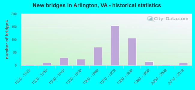
- New bridges - historical statistics
- 11910-1919
- 21920-1929
- 111930-1939
- 301940-1949
- 241950-1959
- 711960-1969
- 1551970-1979
- 1061980-1989
- 151990-1999
- 22000-2009
- 112010-2019
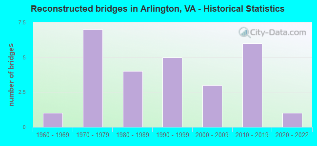
- Reconstructed bridges - Historical Statistics
- 11960-1969
- 71970-1979
- 41980-1989
- 51990-1999
- 32000-2009
- 62010-2019
- 12020-2022
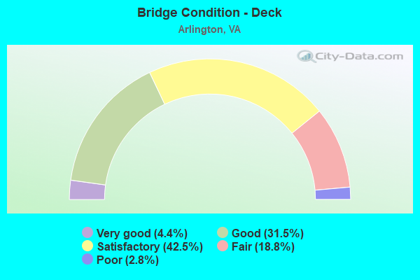
- Bridge Condition - Deck
- 4.4%Very good
- 31.5%Good
- 42.5%Satisfactory
- 18.8%Fair
- 2.8%Poor
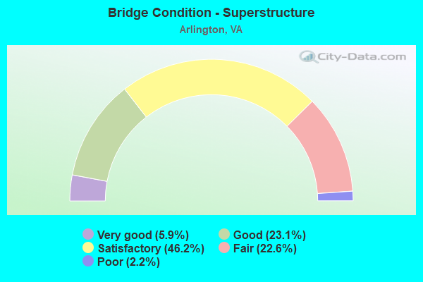
- Bridge Condition - Superstructure
- 5.9%Very good
- 23.1%Good
- 46.2%Satisfactory
- 22.6%Fair
- 2.2%Poor
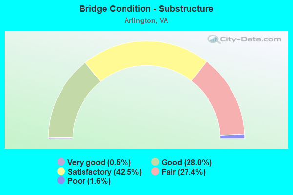
- Bridge Condition - Substructure
- 0.5%Very good
- 28.0%Good
- 42.5%Satisfactory
- 27.4%Fair
- 1.6%Poor
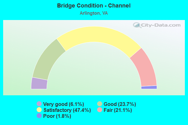
- Bridge Condition - Channel
- 6.1%Very good
- 23.7%Good
- 47.4%Satisfactory
- 21.1%Fair
- 1.8%Poor
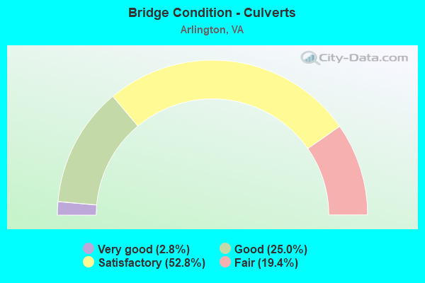
- Bridge Condition - Culverts
- 2.8%Very good
- 25.0%Good
- 52.8%Satisfactory
- 19.4%Fair
Find on map >> Show street view
Structure Number: 27528, Location: 00.86FR50/00.33TO395 (Lat: 38.866003, Lng: -77.073033), Route carried "on" structure: US 27, Year Built: 2013, Status: Open, Structure Length: 4.85m (15.91ft), Average Daily Traffic: 36,856 (year 2020), Truck Traffic: 2%, Average Future Daily Traffic: 51,598 (year 2040), Design Load: HS 20, Features Intersected: COLUMBIA PIKE, Facility Carried by Structure: WASHINGTON BLVD.NB
Minimum Vertical Clearance: 30.18m (99.02ft), Kilometerpoint: 0.113, Lanes on structure: 3, Lanes under structure: 5, Base Highway Network: Yes, Owner: State Highway Agency, Approaching Roadway Width: 15.2m (49.9ft), Skew: 4 degrees, Material/Design: Steel, Design/Construction: Stringer/Multi-beam, Number Of Spans In Main Unit: 1, Length of Maximum Span: 46.3m (151.9ft), Curb-To-Curb Width: 11.0m (36.1ft), Out-to-Out Width: 16.5m (54.1ft)
Condition: Deck: Very good, Superstructure: Very good, Substructure: Very good, Operating Rating: 59.9 metric tons, Method Used To Determine Operating Rating: Load and Resistance Factor (LRFR), Inventory Rating: 46.2 metric tons, Method Used To Determine Inventory Rating: Load and Resistance Factor (LRFR), Structural Evaluation: Equal to present desirable criteria, Deck Geometry: High priority of replacement, Underclear: Equal to present minimum criteria, Approach Roadway Alignment: Better than present minimum criteria, Designated Inspection Frequency: Every 24 months, Inspection Date: November 2021, Deck Structure Type: Concrete Cast-file-Place, Wearing Surface/Protective System: Wearing Surface: Monolithic Concrete, Deck Protection: Epoxy Coated Reinforcing
Find on map >> Show street view
Structure Number: 28579, Location: 00.65FR237/00.98TO120 (Lat: 38.875142, Lng: -77.083875), Route carried "on" structure: US 50, Year Built: 1944, Year Reconstructed: 2007, Status: Open, Structure Length: 2.68m (8.79ft), Average Daily Traffic: 52,258 (year 2020), Truck Traffic: 1%, Average Future Daily Traffic: 66,308 (year 2040), Design Load: HS 20, Features Intersected: Washington Blvd., Facility Carried by Structure: ARLINGTON BLVD.
Minimum Vertical Clearance: 30+ m (98+ ft), Kilometerpoint: 135.257, Lanes on structure: 4, Lanes under structure: 4, Base Highway Network: Yes, Owner: State Highway Agency, Approaching Roadway Width: 11.0m (36.1ft), Skew: 11 degrees, Material/Design: Concrete, Design/Construction: Arch - Deck, Number Of Spans In Main Unit: 2, Length of Maximum Span: 12.8m (42.0ft), Curb or Sidewalk Widths: Left: 2.4m (7.9ft), Right: 2.4m (7.9ft), Curb-To-Curb Width: 11.0m (36.1ft), Out-to-Out Width: 29.2m (95.8ft)
Condition: Superstructure: Good, Substructure: Fair, Operating Rating: 46.3 metric tons, Method Used To Determine Operating Rating: Load and Resistance Factor (LRFR), Inventory Rating: 36.3 metric tons, Method Used To Determine Inventory Rating: Load and Resistance Factor (LRFR), Structural Evaluation: Somewhat better than minimum adequacy, Deck Geometry: High priority of replacement, Underclear: High priority of replacement, Approach Roadway Alignment: Equal to present desirable criteria, Length Of Structure Improvement: 0.03m (0.10ft), Designated Inspection Frequency: Every 24 months, Inspection Date: July 2021, Bridge Improvement Cost: $1,000, Roadway Improvement Cost: $1,000, Total Project Cost: $3,000 ( Estimate for 2015)
Find on map >> Show street view
Structure Number: 29953, Location: _ (Lat: 38.914558, Lng: -77.143483), Route carried "on" structure: County highway , Year Built: 2012, Status: Open, Structure Length: 0.79m (2.59ft), Average Daily Traffic: 500 (year 2012), Truck Traffic: 20%, Average Future Daily Traffic: 1,000 (year 2034), Design Load: HS 20, Features Intersected: Little Pimmit Run, Facility Carried by Structure: DUMBARTON STREET
Minimum Vertical Clearance: 30.18m (99.02ft), Kilometerpoint: 0.000, Lanes on structure: 2, Owner: County Highway Agency, Approaching Roadway Width: 7.3m (24.0ft), Material/Design: Steel, Design/Construction: Culvert, Number Of Spans In Main Unit: 2, Length of Maximum Span: 3.7m (12.1ft), Curb-To-Curb Width: 7.3m (24.0ft), Out-to-Out Width: 7.3m (24.0ft)
Condition: Channel: Satisfactory, Culverts: Satisfactory, Operating Rating: 36.3 metric tons, Method Used To Determine Operating Rating: Field evaluation and documented engineering judgment, Inventory Rating: 32.7 metric tons, Method Used To Determine Inventory Rating: Field evaluation and documented engineering judgment, Structural Evaluation: Equal to present minimum criteria, Deck Geometry: Meets minimum limits, Approach Roadway Alignment: Equal to present minimum criteria, Length Of Structure Improvement: 0.30m (0.98ft), Designated Inspection Frequency: Every 24 months, Inspection Date: Febuary 2022, Bridge Improvement Cost: $1,000, Roadway Improvement Cost: $1,000, Total Project Cost: $3,000 ( Estimate for 2017)
Find on map >> Show street view
Structure Number: 30143, Location: 0.1MileEofLittleFallsCh (Lat: 38.888000, Lng: -77.165300), Route carried "on" structure: ServiceCity street , Year Built: 1990, Status: Open, Structure Length: 1.04m (3.41ft), Average Daily Traffic: 50 (year 2013), Truck Traffic: 5%, Average Future Daily Traffic: 70 (year 2034), Design Load: HS 20, Features Intersected: 4 mile run, Facility Carried by Structure: FIRE DPT ACCESS RD
Minimum Vertical Clearance: 30+ m (98+ ft), Kilometerpoint: 0.000, Lanes on structure: 2, Owner: City or Municipal Highway Agency, Approaching Roadway Width: 6.7m (22.0ft), Skew: 4 degrees, Material/Design: Prestressed concrete, Design/Construction: Frame, Number Of Spans In Main Unit: 1, Length of Maximum Span: 10.4m (34.1ft), Curb-To-Curb Width: 6.7m (22.0ft), Out-to-Out Width: 7.3m (24.0ft)
Condition: Deck: Good, Superstructure: Good, Substructure: Good, Channel: Satisfactory, Operating Rating: 43.5 metric tons, Method Used To Determine Operating Rating: Field evaluation and documented engineering judgment, Inventory Rating: 26.3 metric tons, Method Used To Determine Inventory Rating: Field evaluation and documented engineering judgment, Structural Evaluation: Equal to present minimum criteria, Deck Geometry: Somewhat better than minimum adequacy, Waterway Adequacy: Superior to present desirable criteria, Approach Roadway Alignment: Equal to present desirable criteria, Length Of Structure Improvement: 0.30m (0.98ft), Designated Inspection Frequency: Every 24 months, Inspection Date: January 2022, Bridge Improvement Cost: $1,000, Roadway Improvement Cost: $1,000, Total Project Cost: $3,000 ( Estimate for 2016), Deck Structure Type: Concrete Precast Panels, Wearing Surface/Protective System: Wearing Surface: Integral Concrete
Find on map >> Show street view
Structure Number: 30586, Location: 00.01 FR27/ 01.06TO120 (Lat: 38.866286, Lng: -77.073619), Route carried "on" structure: State highway 244, Year Built: 2015, Status: Open, Structure Length: 0.67m (2.20ft), Average Daily Traffic: 5,855 (year 2020), Truck Traffic: 3%, Average Future Daily Traffic: 6,440 (year 2040), Design Load: HS 20, Features Intersected: LONG BRANCH, Facility Carried by Structure: COLUMBIA PIKE
Minimum Vertical Clearance: 30.18m (99.02ft), Kilometerpoint: 0.000, Lanes on structure: 4, Toll: On toll road, Owner: State Highway Agency, Approaching Roadway Width: 14.6m (47.9ft), Skew: 1 degrees, Material/Design: Concrete, Design/Construction: Culvert, Number Of Spans In Main Unit: 2, Length of Maximum Span: 3.0m (9.8ft)
Condition: Channel: Good, Culverts: Good, Operating Rating: 89.8 metric tons, Method Used To Determine Operating Rating: Load Factor (LF), Inventory Rating: 70.8 metric tons, Method Used To Determine Inventory Rating: Load Factor (LF), Structural Evaluation: Better than present minimum criteria, Waterway Adequacy: Equal to present desirable criteria, Approach Roadway Alignment: Better than present minimum criteria, Designated Inspection Frequency: Every 24 months, Inspection Date: May 2021
Find on map >> Show street view
Structure Number: 31131, Location: T.R. BR OVER LITTLE RIVER (Lat: 38.892167, Lng: -77.065889), Route carried "on" structure: Interstate 66, Year Built: 1964, Status: Open, Structure Length: 32.57m (106.86ft), Average Daily Traffic: 96,880 (year 2010), Truck Traffic: 1%, Average Future Daily Traffic: 107,550 (year 2030), Design Load: HS 20, Features Intersected: LITTLER RIVER & GWP PKWY
Minimum Vertical Clearance: 5.58m (18.31ft), Kilometerpoint: 120.305, Lanes on structure: 6, Lanes under structure: 5, Base Highway Network: Yes, Owner: Local Agency, Approaching Roadway Width: 25.6m (84.0ft), Skew: 39 degrees, Material/Design: Steel continuous, Design/Construction: Stringer/Multi-beam, Number Of Spans In Main Unit: 8, Length of Maximum Span: 43.0m (141.1ft), Curb or Sidewalk Widths: Left: 2.1m (6.9ft), Right: 2.1m (6.9ft), Curb-To-Curb Width: 24.4m (80.1ft), Out-to-Out Width: 27.7m (90.9ft)
Condition: Deck: Fair, Superstructure: Fair, Substructure: Satisfactory, Channel: Good, Operating Rating: 54.4 metric tons, Method Used To Determine Operating Rating: Load Factor (LF), Inventory Rating: 32.7 metric tons, Method Used To Determine Inventory Rating: Load Factor (LF), Structural Evaluation: Somewhat better than minimum adequacy, Deck Geometry: Meets minimum limits, Underclear: Somewhat better than minimum adequacy, Waterway Adequacy: Equal to present desirable criteria, Approach Roadway Alignment: Equal to present desirable criteria, Length Of Structure Improvement: 32.89m (107.91ft), Designated Inspection Frequency: Every 24 months, Critical Feature Inspection Frequency: Every 24 months, Underwater Inspection Frequency: Every 60 months, Inspection Date: Febuary 2020, Critical Feature Inspection Date: Febuary 2020, Underwater Inspection Date: Febuary 2018, Bridge Improvement Cost: $10,000, Roadway Improvement Cost: $3,000, Total Project Cost: $13,000, Deck Structure Type: Concrete Cast-file-Place, Wearing Surface/Protective System: Wearing Surface: Latex Concrete
Find on map >> Show street view
Structure Number: 31132, Location: TR BR ON-RAMP FROM US 50 (Lat: 38.890944, Lng: -77.065694), Route carried "on" structure: Ramp Interstate 66, Year Built: 1964, Status: Open, Structure Length: 22.49m (73.79ft), Average Daily Traffic: 15,000 (year 1992), Truck Traffic: 1%, Average Future Daily Traffic: 15,000 (year 2012), Design Load: HS 20, Features Intersected: LITTLE RVR; RAMP & GW PK, Facility Carried by Structure: US 50 RAMP
Minimum Vertical Clearance: 5.06m (16.60ft), Kilometerpoint: 0.000, Lanes on structure: 2, Lanes under structure: 4, Base Highway Network: Yes, Owner: Local Agency, Approaching Roadway Width: 6.7m (22.0ft), Skew: 9 degrees, Material/Design: Steel continuous, Design/Construction: Stringer/Multi-beam, Number Of Spans In Main Unit: 8, Length of Maximum Span: 42.7m (140.1ft), Curb or Sidewalk Widths: Left: 0.5m (1.6ft), Right: 1.8m (5.9ft), Curb-To-Curb Width: 6.7m (22.0ft), Out-to-Out Width: 9.5m (31.2ft)
Condition: Deck: Fair, Superstructure: Fair, Substructure: Good, Channel: Good, Operating Rating: 59.0 metric tons, Method Used To Determine Operating Rating: Load Factor (LF), Inventory Rating: 35.4 metric tons, Method Used To Determine Inventory Rating: Load Factor (LF), Structural Evaluation: Somewhat better than minimum adequacy, Deck Geometry: High priority of replacement, Underclear: Superior to present desirable criteria, Waterway Adequacy: Equal to present desirable criteria, Approach Roadway Alignment: Equal to present desirable criteria, Length Of Structure Improvement: 22.49m (73.79ft), Designated Inspection Frequency: Every 24 months, Critical Feature Inspection Frequency: Every 24 months, Underwater Inspection Frequency: Every 60 months, Inspection Date: Febuary 2020, Critical Feature Inspection Date: Febuary 2020, Underwater Inspection Date: Febuary 2018, Bridge Improvement Cost: $5,000,000, Roadway Improvement Cost: $250,000, Total Project Cost: $5,250,000, Deck Structure Type: Concrete Cast-file-Place, Wearing Surface/Protective System: Wearing Surface: Bituminous
Find on map >> Show street view
Structure Number: 31133, Location: TR BR OFF-RAMP TO US 50 (Lat: 38.890900, Lng: -77.065700), Route carried "on" structure: Ramp Interstate 66, Year Built: 1964, Status: Open, Structure Length: 17.07m (56.00ft), Average Daily Traffic: 40,000 (year 1992), Truck Traffic: 1%, Average Future Daily Traffic: 30,000 (year 2012), Design Load: HS 20, Features Intersected: LITTLE RVR; RAMP & GW PK
Minimum Vertical Clearance: 4.34m (14.24ft), Kilometerpoint: 0.000, Lanes on structure: 2, Lanes under structure: 4, Owner: Local Agency, Approaching Roadway Width: 10.4m (34.1ft), Skew: 9 degrees, Material/Design: Steel continuous, Design/Construction: Girder and Floorbeam System, Number Of Spans In Main Unit: 4, Number Of Approach Spans: 2, Length of Maximum Span: 49.4m (162.1ft), Curb or Sidewalk Widths: Left: 0.5m (1.6ft), Right: 0.5m (1.6ft), Curb-To-Curb Width: 6.7m (22.0ft), Out-to-Out Width: 10.8m (35.4ft)
Condition: Deck: Fair, Superstructure: Satisfactory, Substructure: Good, Channel: Good, Operating Rating: 58.1 metric tons, Method Used To Determine Operating Rating: Load Factor (LF), Inventory Rating: 34.5 metric tons, Method Used To Determine Inventory Rating: Load Factor (LF), Structural Evaluation: Equal to present minimum criteria, Deck Geometry: High priority of replacement, Underclear: Somewhat better than minimum adequacy, Waterway Adequacy: Equal to present desirable criteria, Approach Roadway Alignment: Equal to present desirable criteria, Length Of Structure Improvement: 17.07m (56.00ft), Designated Inspection Frequency: Every 24 months, Critical Feature Inspection Frequency: Every 24 months, Underwater Inspection Frequency: Every 60 months, Inspection Date: Febuary 2020, Critical Feature Inspection Date: Febuary 2020, Underwater Inspection Date: Febuary 2018, Bridge Improvement Cost: $5,000,000, Roadway Improvement Cost: $500,000, Total Project Cost: $5,500,000, Deck Structure Type: Concrete Cast-file-Place, Wearing Surface/Protective System: Wearing Surface: Bituminous
Find on map >> Show street view
Structure Number: 31134, Location: TR BR OFF-RAMP TO GW PKWY (Lat: 38.891900, Lng: -77.065700), Route carried "on" structure: Ramp Interstate 66, Year Built: 1964, Status: Open, Structure Length: 13.05m (42.81ft), Average Daily Traffic: 17,500 (year 1992), Truck Traffic: 1%, Average Future Daily Traffic: 20,000 (year 2020), Design Load: HS 20, Features Intersected: LITTLE RIVER
Minimum Vertical Clearance: 5.06m (16.60ft), Kilometerpoint: 0.000, Lanes on structure: 1, Base Highway Network: Yes, Owner: Local Agency, Approaching Roadway Width: 5.5m (18.0ft), Material/Design: Steel continuous, Design/Construction: Girder and Floorbeam System, Number Of Spans In Main Unit: 3, Number Of Approach Spans: 2, Length of Maximum Span: 46.6m (152.9ft), Curb or Sidewalk Widths: Left: 0.5m (1.6ft), Right: 1.8m (5.9ft), Curb-To-Curb Width: 5.5m (18.0ft), Out-to-Out Width: 8.3m (27.2ft)
Condition: Deck: Fair, Superstructure: Satisfactory, Substructure: Good, Channel: Good, Operating Rating: 60.8 metric tons, Method Used To Determine Operating Rating: Load Factor (LF), Inventory Rating: 36.3 metric tons, Method Used To Determine Inventory Rating: Load Factor (LF), Structural Evaluation: Equal to present minimum criteria, Deck Geometry: Meets minimum limits, Waterway Adequacy: Equal to present desirable criteria, Approach Roadway Alignment: Equal to present desirable criteria, Length Of Structure Improvement: 13.05m (42.81ft), Designated Inspection Frequency: Every 24 months, Critical Feature Inspection Frequency: Every 24 months, Underwater Inspection Frequency: Every 60 months, Inspection Date: Febuary 2020, Critical Feature Inspection Date: Febuary 2020, Underwater Inspection Date: May 2021, Bridge Improvement Cost: $5,000,000, Roadway Improvement Cost: $500,000, Total Project Cost: $5,500,000, Deck Structure Type: Concrete Cast-file-Place, Wearing Surface/Protective System: Wearing Surface: Bituminous
Find on map >> Show street view
Structure Number: 31274, Location: .01fr30thSt./.01toN.Beech (Lat: 38.911250, Lng: -77.113417), Route carried "on" structure: City street , Year Built: 2004, Status: Open, Structure Length: 0.78m (2.56ft), Average Daily Traffic: 8,300 (year 2017), Truck Traffic: 1%, Average Future Daily Traffic: 10,000 (year 2030), Design Load: HS 20, Features Intersected: DONALDSON RUN, Facility Carried by Structure: MILITARY RD
Minimum Vertical Clearance: 30.45m (99.90ft), Kilometerpoint: 0.000, Lanes on structure: 2, Owner: City or Municipal Highway Agency, Approaching Roadway Width: 13.1m (43.0ft), Material/Design: Concrete, Design/Construction: Arch - Deck, Number Of Spans In Main Unit: 1, Length of Maximum Span: 7.8m (25.6ft), Curb-To-Curb Width: 13.1m (43.0ft), Out-to-Out Width: 21.9m (71.9ft)
Condition: Deck: Good, Superstructure: Good, Substructure: Good, Channel: Good, Operating Rating: 32.7 metric tons, Method Used To Determine Operating Rating: Field evaluation and documented engineering judgment, Inventory Rating: 32.7 metric tons, Method Used To Determine Inventory Rating: Field evaluation and documented engineering judgment, Structural Evaluation: Better than present minimum criteria, Deck Geometry: Somewhat better than minimum adequacy, Waterway Adequacy: Better than present minimum criteria, Approach Roadway Alignment: Better than present minimum criteria, Designated Inspection Frequency: Every 24 months, Inspection Date: April 2021
Find on map >> Show street view
Structure Number: 2110001P, Location: 0.2 MILES FROM VA ROUTE 2 (Lat: 38.847556, Lng: -77.047278), Route carried "on" structure: Other road 901, Year Built: 1941, Status: Open, Structure Length: 1.32m (4.33ft), Average Daily Traffic: 5,000 (year 2009), Average Future Daily Traffic: 5,500 (year 2029), Design Load: H 20, Features Intersected: ABINGDON DRIVE, Facility Carried by Structure: SMITH BOULEVARD
Minimum Vertical Clearance: 30+ m (98+ ft), Kilometerpoint: 0.000, Lanes on structure: 2, Lanes under structure: 2, Owner: Metropolitan Washington Airports Service, Approaching Roadway Width: 9.1m (29.9ft), Material/Design: Concrete, Design/Construction: Frame, Number Of Spans In Main Unit: 1, Length of Maximum Span: 11.0m (36.1ft), Curb or Sidewalk Widths: Left: 1.2m (3.9ft), Right: 1.2m (3.9ft), Curb-To-Curb Width: 9.4m (30.8ft), Out-to-Out Width: 12.8m (42.0ft)
Condition: Deck: Satisfactory, Superstructure: Satisfactory, Substructure: Fair, Operating Rating: 43.5 metric tons, Method Used To Determine Operating Rating: Allowable Stress (AS), Inventory Rating: 26.0 metric tons, Method Used To Determine Inventory Rating: Allowable Stress (AS), Structural Evaluation: Somewhat better than minimum adequacy, Deck Geometry: Meets minimum limits, Approach Roadway Alignment: Equal to present desirable criteria, Designated Inspection Frequency: Every 24 months, Inspection Date: September 2019, Bridge Improvement Cost: $25,000, Roadway Improvement Cost: $3,000, Total Project Cost: $38,000 ( Estimate for 2017), Deck Structure Type: Concrete Cast-file-Place, Wearing Surface/Protective System: Wearing Surface: Bituminous
Find on map >> Show street view
Structure Number: 2110003P, Location: 0.2 MILES FROM AIRPORT TE (Lat: 38.856722, Lng: -77.045056), Route carried "on" structure: Other road 901, Year Built: 1992, Status: Open, Structure Length: 2.99m (9.81ft), Average Daily Traffic: 5,000 (year 2009), Average Future Daily Traffic: 5,500 (year 2029), Design Load: HS 20, Features Intersected: RAMP "R", Facility Carried by Structure: RAMP "G"
Minimum Vertical Clearance: 30+ m (98+ ft), Kilometerpoint: 0.000, Lanes on structure: 1, Lanes under structure: 2, Owner: Metropolitan Washington Airports Service, Approaching Roadway Width: 8.2m (26.9ft), Skew: 5 degrees, Material/Design: Steel, Design/Construction: Stringer/Multi-beam, Number Of Spans In Main Unit: 1, Length of Maximum Span: 29.0m (95.1ft), Curb-To-Curb Width: 8.2m (26.9ft), Out-to-Out Width: 9.1m (29.9ft)
Condition: Deck: Good, Superstructure: Satisfactory, Substructure: Good, Operating Rating: 33.0 metric tons, Method Used To Determine Operating Rating: Allowable Stress (AS), Inventory Rating: 24.0 metric tons, Method Used To Determine Inventory Rating: Allowable Stress (AS), Structural Evaluation: Equal to present minimum criteria, Deck Geometry: High priority of corrective action, Approach Roadway Alignment: Equal to present desirable criteria, Designated Inspection Frequency: Every 24 months, Inspection Date: September 2019, Bridge Improvement Cost: $20,000, Roadway Improvement Cost: $2,000, Total Project Cost: $30,000 ( Estimate for 2017), Deck Structure Type: Concrete Cast-file-Place
Find on map >> Show street view
Structure Number: 2110004P, Location: AIRPORT TERMINAL (Lat: 38.851222, Lng: -77.042250), Route carried "on" structure: Ramp Other road , Year Built: 1997, Status: Open, Structure Length: 60.20m (197.51ft), Average Daily Traffic: 5,000 (year 2009), Average Future Daily Traffic: 5,500 (year 2029), Design Load: HS 20, Features Intersected: RAMP "N", Facility Carried by Structure: RAMP "H"
Minimum Vertical Clearance: 30+ m (98+ ft), Kilometerpoint: 0.000, Lanes on structure: 3, Lanes under structure: 4, Owner: Metropolitan Washington Airports Service, Approaching Roadway Width: 12.2m (40.0ft), Material/Design: Steel continuous, Design/Construction: Girder and Floorbeam System, Number Of Spans In Main Unit: 37, Number Of Approach Spans: 8, Length of Maximum Span: 13.4m (44.0ft), Curb or Sidewalk Widths: Left: 0.6m (2.0ft), Right: 6.1m (20.0ft), Curb-To-Curb Width: 18.3m (60.0ft), Out-to-Out Width: 25.4m (83.3ft)
Condition: Deck: Satisfactory, Superstructure: Good, Substructure: Satisfactory, Operating Rating: 54.4 metric tons, Method Used To Determine Operating Rating: Allowable Stress (AS), Inventory Rating: 33.0 metric tons, Method Used To Determine Inventory Rating: Allowable Stress (AS), Structural Evaluation: Equal to present minimum criteria, Deck Geometry: Superior to present desirable criteria, Approach Roadway Alignment: Equal to present desirable criteria, Designated Inspection Frequency: Every 24 months, Critical Feature Inspection Frequency: Every 24 months, Inspection Date: September 2019, Critical Feature Inspection Date: September 2019, Bridge Improvement Cost: $565,000, Roadway Improvement Cost: $57,000, Total Project Cost: $848,000 ( Estimate for 2017), Deck Structure Type: Concrete Cast-file-Place
Find on map >> Show street view
Structure Number: 2110005P, Location: 0.4 MILES FROM AIRPORT TE (Lat: 38.857639, Lng: -77.046111), Route carried "on" structure: Ramp Other road , Year Built: 1996, Status: Open, Structure Length: 2.19m (7.19ft), Average Daily Traffic: 5,000 (year 2009), Average Future Daily Traffic: 5,500 (year 2029), Design Load: HS 20, Features Intersected: METRORAIL, Facility Carried by Structure: RAMP "A"
Minimum Vertical Clearance: 30+ m (98+ ft), Kilometerpoint: 0.000, Lanes on structure: 2, Owner: Metropolitan Washington Airports Service, Approaching Roadway Width: 11.0m (36.1ft), Skew: 1 degrees, Material/Design: Prestressed concrete, Design/Construction: Box Beam or Girders - Multiple, Number Of Spans In Main Unit: 1, Length of Maximum Span: 21.3m (69.9ft), Curb-To-Curb Width: 11.0m (36.1ft), Out-to-Out Width: 11.9m (39.0ft)
Condition: Deck: Good, Superstructure: Very good, Substructure: Good, Operating Rating: 54.4 metric tons, Method Used To Determine Operating Rating: Allowable Stress (AS), Inventory Rating: 33.0 metric tons, Method Used To Determine Inventory Rating: Allowable Stress (AS), Structural Evaluation: Better than present minimum criteria, Deck Geometry: Better than present minimum criteria, Approach Roadway Alignment: Equal to present desirable criteria, Designated Inspection Frequency: Every 24 months, Inspection Date: September 2019, Deck Structure Type: Concrete Cast-file-Place
Find on map >> Show street view
Structure Number: 2110006P, Location: 0.3 MILES FROM AIRPORT TE (Lat: 38.857556, Lng: -77.045278), Route carried "on" structure: Ramp Other road , Year Built: 1994, Status: Open, Structure Length: 3.02m (9.91ft), Average Daily Traffic: 5,000 (year 2009), Average Future Daily Traffic: 5,500 (year 2029), Design Load: HS 20, Features Intersected: RAMP "G", Facility Carried by Structure: RAMP "A"
Minimum Vertical Clearance: 30+ m (98+ ft), Kilometerpoint: 0.000, Lanes on structure: 2, Lanes under structure: 1, Owner: Metropolitan Washington Airports Service, Approaching Roadway Width: 7.9m (25.9ft), Skew: 4 degrees, Material/Design: Steel, Design/Construction: Stringer/Multi-beam, Number Of Spans In Main Unit: 1, Length of Maximum Span: 27.4m (89.9ft), Curb-To-Curb Width: 8.6m (28.2ft), Out-to-Out Width: 9.7m (31.8ft)
Condition: Deck: Good, Superstructure: Good, Substructure: Good, Operating Rating: 54.4 metric tons, Method Used To Determine Operating Rating: Allowable Stress (AS), Inventory Rating: 33.0 metric tons, Method Used To Determine Inventory Rating: Allowable Stress (AS), Structural Evaluation: Better than present minimum criteria, Deck Geometry: Meets minimum limits, Approach Roadway Alignment: Equal to present desirable criteria, Designated Inspection Frequency: Every 24 months, Inspection Date: September 2019, Bridge Improvement Cost: $50,000, Roadway Improvement Cost: $5,000, Total Project Cost: $75,000 ( Estimate for 2017), Deck Structure Type: Concrete Cast-file-Place
Find on map >> Show street view
Structure Number: 2110007P, Location: 0.2 MILES FROM AIRPORT TE (Lat: 38.857139, Lng: -77.045167), Route carried "on" structure: Ramp Other road , Year Built: 1997, Status: Open, Structure Length: 2.94m (9.65ft), Average Daily Traffic: 5,000 (year 2009), Average Future Daily Traffic: 5,500 (year 2029), Design Load: HS 20, Features Intersected: RAMP "R", Facility Carried by Structure: RAMP "A"
Minimum Vertical Clearance: 30+ m (98+ ft), Kilometerpoint: 0.000, Lanes on structure: 2, Lanes under structure: 2, Owner: Metropolitan Washington Airports Service, Approaching Roadway Width: 9.6m (31.5ft), Material/Design: Steel, Design/Construction: Stringer/Multi-beam, Number Of Spans In Main Unit: 1, Length of Maximum Span: 29.0m (95.1ft), Curb-To-Curb Width: 8.9m (29.2ft), Out-to-Out Width: 10.0m (32.8ft)
Condition: Deck: Good, Superstructure: Good, Substructure: Good, Operating Rating: 54.4 metric tons, Method Used To Determine Operating Rating: Allowable Stress (AS), Inventory Rating: 33.0 metric tons, Method Used To Determine Inventory Rating: Allowable Stress (AS), Structural Evaluation: Better than present minimum criteria, Deck Geometry: Meets minimum limits, Approach Roadway Alignment: Equal to present desirable criteria, Designated Inspection Frequency: Every 24 months, Inspection Date: September 2019, Deck Structure Type: Concrete Cast-file-Place
Find on map >> Show street view
Structure Number: 2110008P, Location: 0.2 MILES FROM AIRPORT TE (Lat: 38.856917, Lng: -77.044972), Route carried "on" structure: Ramp Other road , Year Built: 1997, Status: Open, Structure Length: 3.02m (9.91ft), Average Daily Traffic: 5,000 (year 2009), Average Future Daily Traffic: 5,500 (year 2029), Design Load: HS 20, Features Intersected: RAMP "R", Facility Carried by Structure: RAMP "E"
Minimum Vertical Clearance: 30+ m (98+ ft), Kilometerpoint: 0.000, Lanes on structure: 1, Lanes under structure: 2, Owner: Metropolitan Washington Airports Service, Approaching Roadway Width: 6.1m (20.0ft), Material/Design: Steel, Design/Construction: Stringer/Multi-beam, Number Of Spans In Main Unit: 1, Length of Maximum Span: 29.0m (95.1ft), Curb-To-Curb Width: 4.8m (15.7ft), Out-to-Out Width: 5.9m (19.4ft)
Condition: Deck: Good, Superstructure: Good, Substructure: Good, Operating Rating: 54.4 metric tons, Method Used To Determine Operating Rating: Allowable Stress (AS), Inventory Rating: 33.0 metric tons, Method Used To Determine Inventory Rating: Allowable Stress (AS), Structural Evaluation: Better than present minimum criteria, Deck Geometry: High priority of replacement, Approach Roadway Alignment: Equal to present desirable criteria, Designated Inspection Frequency: Every 24 months, Inspection Date: September 2019, Deck Structure Type: Concrete Cast-file-Place
Find on map >> Show street view
Structure Number: 2160001P, Location: I-395 SOUTH TO VA ROUTE 1 (Lat: 38.868944, Lng: -77.051722), Route carried "on" structure: Business Federal lands road , Year Built: 1945, Status: Open, Structure Length: 3.08m (10.10ft), Average Daily Traffic: 6,460 (year 2012), Truck Traffic: 1%, Average Future Daily Traffic: 7,106 (year 2032), Features Intersected: VA ROUTE 110, Facility Carried by Structure: BUS AND TAXI ENTRA
Minimum Vertical Clearance: 30+ m (98+ ft), Kilometerpoint: 0.499, Lanes on structure: 4, Lanes under structure: 6, Owner: Pentagon, Approaching Roadway Width: 20.1m (65.9ft), Skew: 20 degrees, Material/Design: Concrete, Design/Construction: Frame, Number Of Spans In Main Unit: 2, Length of Maximum Span: 14.6m (47.9ft), Curb or Sidewalk Widths: Left: 1.2m (3.9ft), Right: 1.4m (4.6ft), Curb-To-Curb Width: 16.5m (54.1ft), Out-to-Out Width: 20.1m (65.9ft)
Condition: Deck: Fair, Superstructure: Fair, Substructure: Satisfactory, Operating Rating: 32.7 metric tons, Method Used To Determine Operating Rating: Field evaluation and documented engineering judgment, Inventory Rating: 19.0 metric tons, Method Used To Determine Inventory Rating: Field evaluation and documented engineering judgment, Structural Evaluation: Meets minimum limits, Deck Geometry: Meets minimum limits, Underclear: High priority of corrective action, Approach Roadway Alignment: Equal to present desirable criteria, Designated Inspection Frequency: Every 24 months, Inspection Date: June 2021, Bridge Improvement Cost: $770,000, Roadway Improvement Cost: $77,000, Total Project Cost: $1,155,000 ( Estimate for 2021), Deck Structure Type: Concrete Cast-file-Place, Wearing Surface/Protective System: Wearing Surface: Bituminous
Find on map >> Show street view
Structure Number: 2160002P, Location: I-395 SOUTH TO VA ROUTE 1 (Lat: 38.871611, Lng: -77.052750), Route carried "on" structure: Business Federal lands road , Year Built: 1945, Year Reconstructed: 1998, Status: Open, Structure Length: 4.91m (16.11ft), Average Daily Traffic: 6,120 (year 2012), Truck Traffic: 1%, Average Future Daily Traffic: 6,120 (year 2032), Features Intersected: VA ROUTE 110, Facility Carried by Structure: PENTAGON RIVER ENT
Minimum Vertical Clearance: 30+ m (98+ ft), Kilometerpoint: 0.821, Lanes on structure: 2, Lanes under structure: 2, Owner: Pentagon, Approaching Roadway Width: 8.5m (27.9ft), Material/Design: Concrete, Design/Construction: Tee Beam, Number Of Spans In Main Unit: 3, Number Of Approach Spans: 2, Length of Maximum Span: 17.1m (56.1ft), Curb or Sidewalk Widths: Left: 0.6m (2.0ft), Right: 1.0m (3.3ft), Curb-To-Curb Width: 8.5m (27.9ft), Out-to-Out Width: 11.3m (37.1ft)
Condition: Deck: Satisfactory, Superstructure: Good, Substructure: Satisfactory, Operating Rating: 54.4 metric tons, Method Used To Determine Operating Rating: Field evaluation and documented engineering judgment, Inventory Rating: 32.7 metric tons, Method Used To Determine Inventory Rating: Field evaluation and documented engineering judgment, Structural Evaluation: Equal to present minimum criteria, Deck Geometry: High priority of replacement, Underclear: Somewhat better than minimum adequacy, Approach Roadway Alignment: Equal to present desirable criteria, Designated Inspection Frequency: Every 24 months, Inspection Date: June 2021, Bridge Improvement Cost: $100,000, Roadway Improvement Cost: $10,000, Total Project Cost: $150,000 ( Estimate for 2021), Deck Structure Type: Concrete Cast-file-Place
Find on map >> Show street view
Structure Number: 2160005P, Location: I-395 SOUTH TO VA ROUTE 1 (Lat: 38.868750, Lng: -77.052694), Route carried "on" structure: Business Federal lands road , Year Built: 1945, Status: Open, Structure Length: 1.04m (3.41ft), Average Daily Traffic: 6,460 (year 2012), Truck Traffic: 1%, Average Future Daily Traffic: 7,106 (year 2032), Design Load: H 20, Features Intersected: EADS STREET, Facility Carried by Structure: BUS AND TAXI ENTRY
Minimum Vertical Clearance: 30+ m (98+ ft), Kilometerpoint: 0.000, Lanes on structure: 4, Lanes under structure: 2, Owner: Pentagon, Approaching Roadway Width: 20.1m (65.9ft), Skew: 24 degrees, Material/Design: Concrete, Design/Construction: Frame, Number Of Spans In Main Unit: 1, Length of Maximum Span: 10.4m (34.1ft), Curb or Sidewalk Widths: Left: 1.2m (3.9ft), Right: 1.4m (4.6ft), Curb-To-Curb Width: 41.0m (134.5ft), Out-to-Out Width: 41.0m (134.5ft)
Condition: Deck: Fair, Superstructure: Fair, Substructure: Satisfactory, Operating Rating: 32.7 metric tons, Method Used To Determine Operating Rating: Field evaluation and documented engineering judgment, Inventory Rating: 19.0 metric tons, Method Used To Determine Inventory Rating: Field evaluation and documented engineering judgment, Structural Evaluation: Meets minimum limits, Deck Geometry: Superior to present desirable criteria, Underclear: High priority of corrective action, Approach Roadway Alignment: Equal to present desirable criteria, Designated Inspection Frequency: Every 24 months, Inspection Date: June 2021, Bridge Improvement Cost: $1,130,000, Roadway Improvement Cost: $113,000, Total Project Cost: $1,695,000 ( Estimate for 2021), Deck Structure Type: Concrete Cast-file-Place
Find on map >> Show street view
Structure Number: 2160010P, Location: I-395 SOUTH TO VA ROUTE 1 (Lat: 38.875472, Lng: -77.053889), Route carried "on" structure: Business Federal lands road , Year Built: 2004, Status: Open, Structure Length: 5.43m (17.81ft), Average Daily Traffic: 6,000 (year 2012), Average Future Daily Traffic: 7,200 (year 2032), Features Intersected: VA ROUTE 110, Facility Carried by Structure: PARKING LOT ENTRAN
Minimum Vertical Clearance: 30+ m (98+ ft), Kilometerpoint: 0.000, Lanes on structure: 2, Lanes under structure: 6, Owner: Pentagon, Approaching Roadway Width: 7.9m (25.9ft), Material/Design: Prestressed concrete, Design/Construction: Stringer/Multi-beam, Number Of Spans In Main Unit: 2, Length of Maximum Span: 29.1m (95.5ft), Curb or Sidewalk Widths: Left: 0.0m, Right: 2.4m (7.9ft), Curb-To-Curb Width: 10.4m (34.1ft), Out-to-Out Width: 11.0m (36.1ft)
Condition: Deck: Good, Superstructure: Good, Substructure: Good, Operating Rating: 54.5 metric tons, Method Used To Determine Operating Rating: Field evaluation and documented engineering judgment, Inventory Rating: 32.7 metric tons, Method Used To Determine Inventory Rating: Field evaluation and documented engineering judgment, Structural Evaluation: Better than present minimum criteria, Deck Geometry: Meets minimum limits, Underclear: Somewhat better than minimum adequacy, Approach Roadway Alignment: Equal to present desirable criteria, Designated Inspection Frequency: Every 24 months, Inspection Date: June 2021, Bridge Improvement Cost: $145,000, Roadway Improvement Cost: $15,000, Total Project Cost: $218,000 ( Estimate for 2021), Deck Structure Type: Concrete Cast-file-Place
Find on map >> Show street view
Structure Number: 3300006P, Location: 5.0 MILES FROM I-495. (Lat: 38.927722, Lng: -77.117139), Route carried "on" structure: Federal lands road 1, Year Built: 1959, Year Reconstructed: 1982, Status: Open, Structure Length: 16.58m (54.40ft), Average Daily Traffic: 27,400 (year 2007), Truck Traffic: 1%, Average Future Daily Traffic: 30,140 (year 2027), Design Load: H 20, Features Intersected: GLEBE ROAD & STREAM, Facility Carried by Structure: GWMP
Minimum Vertical Clearance: 30+ m (98+ ft), Kilometerpoint: 7.854, Lanes on structure: 4, Lanes under structure: 2, Owner: National Park Service, Approaching Roadway Width: 16.5m (54.1ft), Skew: 32 degrees, Material/Design: Steel continuous, Design/Construction: Girder and Floorbeam System, Number Of Spans In Main Unit: 4, Length of Maximum Span: 45.7m (149.9ft), Curb-To-Curb Width: 19.1m (62.7ft), Out-to-Out Width: 20.7m (67.9ft)
Condition: Deck: Good, Superstructure: Satisfactory, Substructure: Satisfactory, Channel: Fair, Operating Rating: 42.6 metric tons, Method Used To Determine Operating Rating: Load Factor (LF), Inventory Rating: 25.4 metric tons, Method Used To Determine Inventory Rating: Load Factor (LF), Structural Evaluation: Equal to present minimum criteria, Deck Geometry: Equal to present minimum criteria, Underclear: Meets minimum limits, Approach Roadway Alignment: Equal to present desirable criteria, Length Of Structure Improvement: 16.58m (54.40ft), Designated Inspection Frequency: Every 24 months, Critical Feature Inspection Frequency: Every 24 months, Inspection Date: April 2021, Critical Feature Inspection Date: April 2021, Deck Structure Type: Concrete Cast-file-Place
Find on map >> Show street view
Structure Number: 3300007P, Location: 5.4 MILES SOUTH OF I-495. (Lat: 38.924833, Lng: -77.114250), Route carried "on" structure: Federal lands road 1, Year Built: 1959, Year Reconstructed: 1982, Status: Open, Structure Length: 12.92m (42.39ft), Average Daily Traffic: 27,400 (year 2007), Truck Traffic: 1%, Average Future Daily Traffic: 30,140 (year 2027), Design Load: H 20, Features Intersected: GULF BRANCH, Facility Carried by Structure: GWMP
Minimum Vertical Clearance: 30+ m (98+ ft), Kilometerpoint: 8.401, Lanes on structure: 4, Owner: National Park Service, Approaching Roadway Width: 16.5m (54.1ft), Skew: 30 degrees, Material/Design: Steel continuous, Design/Construction: Girder and Floorbeam System, Number Of Spans In Main Unit: 3, Length of Maximum Span: 48.8m (160.1ft), Curb-To-Curb Width: 19.1m (62.7ft), Out-to-Out Width: 20.7m (67.9ft)
Condition: Deck: Satisfactory, Superstructure: Satisfactory, Substructure: Fair, Channel: Satisfactory, Operating Rating: 36.3 metric tons, Method Used To Determine Operating Rating: Load Factor (LF), Inventory Rating: 20.9 metric tons, Method Used To Determine Inventory Rating: Load Factor (LF), Structural Evaluation: Somewhat better than minimum adequacy, Deck Geometry: Equal to present minimum criteria, Waterway Adequacy: Equal to present desirable criteria, Approach Roadway Alignment: Equal to present desirable criteria, Length Of Structure Improvement: 12.92m (42.39ft), Designated Inspection Frequency: Every 24 months, Critical Feature Inspection Frequency: Every 24 months, Inspection Date: April 2021, Critical Feature Inspection Date: April 2021, Deck Structure Type: Concrete Cast-file-Place
Find on map >> Show street view
Structure Number: 3300008P, Location: 5.8 MILES SOUTH OF I-495. (Lat: 38.919639, Lng: -77.108056), Route carried "on" structure: Federal lands road 1, Year Built: 1959, Year Reconstructed: 1982, Status: Open, Structure Length: 13.06m (42.85ft), Average Daily Traffic: 27,400 (year 2007), Truck Traffic: 1%, Average Future Daily Traffic: 30,140 (year 2027), Design Load: H 20, Features Intersected: DONALDSON RUN, Facility Carried by Structure: GWMP
Minimum Vertical Clearance: 30+ m (98+ ft), Kilometerpoint: 9.189, Lanes on structure: 4, Owner: National Park Service, Approaching Roadway Width: 16.5m (54.1ft), Skew: 30 degrees, Material/Design: Steel continuous, Design/Construction: Girder and Floorbeam System, Number Of Spans In Main Unit: 3, Length of Maximum Span: 49.2m (161.4ft), Curb-To-Curb Width: 19.1m (62.7ft), Out-to-Out Width: 20.7m (67.9ft)
Condition: Deck: Satisfactory, Superstructure: Satisfactory, Substructure: Satisfactory, Channel: Very good, Operating Rating: 42.6 metric tons, Method Used To Determine Operating Rating: Load Factor (LF), Inventory Rating: 25.4 metric tons, Method Used To Determine Inventory Rating: Load Factor (LF), Structural Evaluation: Equal to present minimum criteria, Deck Geometry: Equal to present minimum criteria, Waterway Adequacy: Equal to present desirable criteria, Approach Roadway Alignment: Equal to present desirable criteria, Length Of Structure Improvement: 13.08m (42.91ft), Designated Inspection Frequency: Every 24 months, Critical Feature Inspection Frequency: Every 24 months, Inspection Date: April 2021, Critical Feature Inspection Date: April 2021, Deck Structure Type: Concrete Cast-file-Place, Wearing Surface/Protective System: Wearing Surface: Monolithic Concrete
Find on map >> Show street view
Structure Number: 3300009P, Location: 7.1 MILES SOUTH OF I-495. (Lat: 38.905139, Lng: -77.094056), Route carried "on" structure: Federal lands road 1, Year Built: 1959, Year Reconstructed: 1982, Status: Open, Structure Length: 11.83m (38.81ft), Average Daily Traffic: 27,400 (year 2007), Truck Traffic: 1%, Average Future Daily Traffic: 30,140 (year 2027), Design Load: H 20, Features Intersected: WINDY RUN, Facility Carried by Structure: GWMP
Minimum Vertical Clearance: 30+ m (98+ ft), Kilometerpoint: 11.185, Lanes on structure: 4, Owner: National Park Service, Approaching Roadway Width: 16.5m (54.1ft), Skew: 30 degrees, Material/Design: Steel continuous, Design/Construction: Girder and Floorbeam System, Number Of Spans In Main Unit: 4, Length of Maximum Span: 32.3m (106.0ft), Curb-To-Curb Width: 19.1m (62.7ft), Out-to-Out Width: 20.7m (67.9ft)
Condition: Deck: Satisfactory, Superstructure: Satisfactory, Substructure: Satisfactory, Channel: Satisfactory, Operating Rating: 34.5 metric tons, Method Used To Determine Operating Rating: Load Factor (LF), Inventory Rating: 20.9 metric tons, Method Used To Determine Inventory Rating: Load Factor (LF), Structural Evaluation: Somewhat better than minimum adequacy, Deck Geometry: Equal to present minimum criteria, Waterway Adequacy: Equal to present desirable criteria, Approach Roadway Alignment: Equal to present desirable criteria, Length Of Structure Improvement: 11.80m (38.71ft), Designated Inspection Frequency: Every 24 months, Critical Feature Inspection Frequency: Every 24 months, Inspection Date: April 2021, Critical Feature Inspection Date: April 2021, Deck Structure Type: Concrete Cast-file-Place, Wearing Surface/Protective System: Wearing Surface: Monolithic Concrete
Find on map >> Show street view
Structure Number: 3300011P, Location: 7.8 MILES SOUTH OF I-495. (Lat: 38.902278, Lng: -77.082778), Route carried "on" structure: Federal lands road 2, Year Built: 1958, Status: Open, Structure Length: 0.77m (2.53ft), Average Daily Traffic: 32,750 (year 2013), Truck Traffic: 1%, Average Future Daily Traffic: 36,025 (year 2033), Design Load: H 15, Features Intersected: SPOUT RUN, Facility Carried by Structure: GWMP (NB)
Minimum Vertical Clearance: 30+ m (98+ ft), Kilometerpoint: 11.780, Lanes on structure: 2, Owner: National Park Service, Approaching Roadway Width: 7.3m (24.0ft), Skew: 4 degrees, Material/Design: Concrete, Design/Construction: Arch - Deck, Number Of Spans In Main Unit: 1, Length of Maximum Span: 7.7m (25.3ft), Curb or Sidewalk Widths: Left: 1.2m (3.9ft), Right: 1.0m (3.3ft), Curb-To-Curb Width: 8.4m (27.6ft), Out-to-Out Width: 11.9m (39.0ft)
Condition: Superstructure: Good, Substructure: Satisfactory, Channel: Satisfactory, Inventory Rating: 68.0 metric tons, Method Used To Determine Inventory Rating: Load Factor (LF), Structural Evaluation: Equal to present minimum criteria, Deck Geometry: High priority of corrective action, Waterway Adequacy: Equal to present minimum criteria, Approach Roadway Alignment: Equal to present desirable criteria, Designated Inspection Frequency: Every 24 months, Inspection Date: April 2021
Find on map >> Show street view
Structure Number: 3300012P, Location: 8.4 MILES SOUTH OF I-495. (Lat: 38.900444, Lng: -77.073222), Route carried "on" structure: Alternate Federal lands road 1, Year Built: 1959, Year Reconstructed: 1984, Status: Open, Structure Length: 4.08m (13.39ft), Average Daily Traffic: 16,100 (year 2013), Truck Traffic: 1%, Average Future Daily Traffic: 17,710 (year 2033), Design Load: H 20, Features Intersected: GWMP (SB), Facility Carried by Structure: CONNECTOR RAMP TO
Minimum Vertical Clearance: 30+ m (98+ ft), Kilometerpoint: 0.402, Lanes on structure: 2, Lanes under structure: 2, Owner: National Park Service, Approaching Roadway Width: 6.1m (20.0ft), Skew: 6 degrees, Material/Design: Steel, Design/Construction: Stringer/Multi-beam, Number Of Spans In Main Unit: 1, Length of Maximum Span: 40.8m (133.9ft), Curb-To-Curb Width: 8.1m (26.6ft), Out-to-Out Width: 9.1m (29.9ft)
Condition: Deck: Good, Superstructure: Satisfactory, Substructure: Satisfactory, Operating Rating: 74.4 metric tons, Method Used To Determine Operating Rating: Load Factor (LF), Inventory Rating: 44.4 metric tons, Method Used To Determine Inventory Rating: Load Factor (LF), Structural Evaluation: Equal to present minimum criteria, Deck Geometry: High priority of replacement, Underclear: Equal to present minimum criteria, Approach Roadway Alignment: Equal to present desirable criteria, Designated Inspection Frequency: Every 24 months, Inspection Date: April 2021, Bridge Improvement Cost: $400,000, Roadway Improvement Cost: $40,000, Total Project Cost: $600,000 ( Estimate for 2021), Deck Structure Type: Concrete Cast-file-Place, Wearing Surface/Protective System: Wearing Surface: Monolithic Concrete
Find on map >> Show street view
Structure Number: 3300021P, Location: 1.1 MILES SOUTH OF I-395. (Lat: 38.857278, Lng: -77.046667), Route carried "on" structure: Federal lands road 1, Year Built: 1941, Year Reconstructed: 2007, Status: Open, Structure Length: 1.81m (5.94ft), Average Daily Traffic: 20,800 (year 2007), Truck Traffic: 1%, Average Future Daily Traffic: 22,880 (year 2027), Design Load: H 20, Features Intersected: NORTH ENTRANCE TO NATION, Facility Carried by Structure: GWMP
Minimum Vertical Clearance: 30+ m (98+ ft), Kilometerpoint: 4.731, Lanes on structure: 4, Lanes under structure: 2, Owner: National Park Service, Approaching Roadway Width: 14.6m (47.9ft), Skew: 34 degrees, Material/Design: Steel, Design/Construction: Stringer/Multi-beam, Number Of Spans In Main Unit: 1, Length of Maximum Span: 17.1m (56.1ft), Curb or Sidewalk Widths: Left: 0.0m, Right: 3.9m (12.8ft), Curb-To-Curb Width: 14.6m (47.9ft), Out-to-Out Width: 33.0m (108.3ft)
Condition: Deck: Good, Superstructure: Satisfactory, Substructure: Satisfactory, Operating Rating: 42.6 metric tons, Method Used To Determine Operating Rating: Load Factor (LF), Inventory Rating: 25.4 metric tons, Method Used To Determine Inventory Rating: Load Factor (LF), Structural Evaluation: Equal to present minimum criteria, Deck Geometry: High priority of replacement, Underclear: High priority of corrective action, Approach Roadway Alignment: Equal to present desirable criteria, Designated Inspection Frequency: Every 24 months, Inspection Date: April 2021, Bridge Improvement Cost: $120,000, Roadway Improvement Cost: $12,000, Total Project Cost: $180,000, Deck Structure Type: Concrete Cast-file-Place, Wearing Surface/Protective System: Wearing Surface: Monolithic Concrete
Find on map >> Show street view
Structure Number: 3300027P, Location: 1.8 MILES SOUTH OF I-395. (Lat: 38.847056, Lng: -77.048639), Route carried "on" structure: Alternate Federal lands road 500, Year Built: 1965, Status: Open, Structure Length: 5.85m (19.19ft), Average Daily Traffic: 1,000 (year 2013), Truck Traffic: 10%, Average Future Daily Traffic: 1,100 (year 2033), Design Load: H 20, Features Intersected: GWMP, Facility Carried by Structure: SOUTH EXIT FROM NA
Minimum Vertical Clearance: 30+ m (98+ ft), Kilometerpoint: 0.274, Lanes on structure: 2, Lanes under structure: 4, Owner: National Park Service, Approaching Roadway Width: 7.3m (24.0ft), Skew: 6 degrees, Material/Design: Concrete continuous, Design/Construction: Frame, Number Of Spans In Main Unit: 2, Length of Maximum Span: 35.4m (116.1ft), Curb or Sidewalk Widths: Left: 1.3m (4.3ft), Right: 1.3m (4.3ft), Curb-To-Curb Width: 7.3m (24.0ft), Out-to-Out Width: 10.7m (35.1ft)
Condition: Deck: Good, Superstructure: Satisfactory, Substructure: Good, Operating Rating: 48.1 metric tons, Method Used To Determine Operating Rating: Field evaluation and documented engineering judgment, Inventory Rating: 29.0 metric tons, Method Used To Determine Inventory Rating: Field evaluation and documented engineering judgment, Structural Evaluation: Equal to present minimum criteria, Deck Geometry: High priority of replacement, Underclear: Somewhat better than minimum adequacy, Approach Roadway Alignment: Equal to present desirable criteria, Designated Inspection Frequency: Every 24 months, Inspection Date: April 2021, Bridge Improvement Cost: $20,000, Roadway Improvement Cost: $2,000, Total Project Cost: $22,000, Deck Structure Type: Concrete Cast-file-Place, Wearing Surface/Protective System: Wearing Surface: Latex Concrete
Find on map >> Show street view
Structure Number: 3300028P, Location: 1.6 MILES SOUTH OF I-395. (Lat: 38.849278, Lng: -77.047861), Route carried "on" structure: Alternate Federal lands road 1, Year Built: 1965, Status: Open, Structure Length: 4.07m (13.35ft), Average Daily Traffic: 18,200 (year 2013), Truck Traffic: 1%, Average Future Daily Traffic: 20,020 (year 2033), Design Load: H 20, Features Intersected: GWMP, Facility Carried by Structure: VA ROUTE 233
Minimum Vertical Clearance: 30+ m (98+ ft), Kilometerpoint: 20.455, Lanes on structure: 5, Lanes under structure: 5, Owner: National Park Service, Approaching Roadway Width: 18.6m (61.0ft), Skew: 30 degrees, Material/Design: Concrete, Design/Construction: Box Beam or Girders - Single/Spread, Number Of Spans In Main Unit: 1, Length of Maximum Span: 40.7m (133.5ft), Curb or Sidewalk Widths: Left: 1.5m (4.9ft), Right: 1.5m (4.9ft), Curb-To-Curb Width: 18.6m (61.0ft), Out-to-Out Width: 24.1m (79.1ft)
Condition: Deck: Satisfactory, Superstructure: Satisfactory, Substructure: Good, Operating Rating: 48.1 metric tons, Method Used To Determine Operating Rating: Load Factor (LF), Inventory Rating: 28.1 metric tons, Method Used To Determine Inventory Rating: Load Factor (LF), Structural Evaluation: Equal to present minimum criteria, Deck Geometry: High priority of corrective action, Underclear: Equal to present minimum criteria, Approach Roadway Alignment: Equal to present desirable criteria, Length Of Structure Improvement: 4.05m (13.29ft), Designated Inspection Frequency: Every 24 months, Inspection Date: April 2021, Bridge Improvement Cost: $110,000, Roadway Improvement Cost: $11,000, Total Project Cost: $165,000 ( Estimate for 2021), Deck Structure Type: Concrete Cast-file-Place, Wearing Surface/Protective System: Wearing Surface: Latex Concrete
Find on map >> Show street view
Structure Number: 3300029P, Location: 0.9 MILES EAST OF U.S. 29 (Lat: 38.901889, Lng: -77.083167), Route carried "on" structure: Ramp Federal lands road 5, Year Built: 1949, Status: Open, Structure Length: 0.85m (2.79ft), Average Daily Traffic: 11,400 (year 2013), Truck Traffic: 1%, Average Future Daily Traffic: 12,540 (year 2033), Design Load: H 15, Features Intersected: SPOUT RUN, Facility Carried by Structure: SPOUT RUN PARKWAY
Minimum Vertical Clearance: 30+ m (98+ ft), Kilometerpoint: 1.448, Lanes on structure: 2, Owner: National Park Service, Approaching Roadway Width: 7.3m (24.0ft), Skew: 4 degrees, Material/Design: Concrete, Design/Construction: Arch - Deck, Number Of Spans In Main Unit: 1, Length of Maximum Span: 8.5m (27.9ft), Curb-To-Curb Width: 11.1m (36.4ft), Out-to-Out Width: 12.1m (39.7ft)
Condition: Superstructure: Satisfactory, Substructure: Good, Channel: Satisfactory, Inventory Rating: 56.2 metric tons, Method Used To Determine Inventory Rating: Load Factor (LF), Structural Evaluation: Equal to present minimum criteria, Deck Geometry: Equal to present desirable criteria, Waterway Adequacy: Equal to present desirable criteria, Approach Roadway Alignment: Equal to present desirable criteria, Length Of Structure Improvement: 0.88m (2.89ft), Designated Inspection Frequency: Every 24 months, Inspection Date: April 2021, Bridge Improvement Cost: $65,000, Roadway Improvement Cost: $7,000, Total Project Cost: $92,000 ( Estimate for 2021)
Find on map >> Show street view
Structure Number: 3300039P, Location: 1.1 MILES WEST OF GWMP. (Lat: 38.899139, Lng: -77.089861), Route carried "on" structure: Ramp Federal lands road 4, Year Built: 1947, Status: Open, Structure Length: 0.61m (2.00ft), Average Daily Traffic: 1,000 (year 2013), Truck Traffic: 10%, Average Future Daily Traffic: 1,100 (year 2033), Design Load: H 20, Features Intersected: SPOUT RUN, Facility Carried by Structure: SPOUT RUN PARKWAY
Minimum Vertical Clearance: 30+ m (98+ ft), Kilometerpoint: 0.805, Lanes on structure: 2, Owner: National Park Service, Approaching Roadway Width: 9.1m (29.9ft), Material/Design: Concrete, Design/Construction: Culvert, Number Of Spans In Main Unit: 1, Length of Maximum Span: 6.1m (20.0ft)
Condition: Channel: Satisfactory, Culverts: Good, Operating Rating: 54.4 metric tons, Method Used To Determine Operating Rating: Field evaluation and documented engineering judgment, Inventory Rating: 32.7 metric tons, Method Used To Determine Inventory Rating: Field evaluation and documented engineering judgment, Structural Evaluation: Better than present minimum criteria, Waterway Adequacy: Somewhat better than minimum adequacy, Approach Roadway Alignment: Equal to present desirable criteria, Length Of Structure Improvement: 0.61m (2.00ft), Designated Inspection Frequency: Every 24 months, Inspection Date: April 2021, Bridge Improvement Cost: $5,000, Total Project Cost: $7,000 ( Estimate for 2021)
Find on map >> Show street view
Structure Number: 3300043P, Location: 0.1 MILES SOUTH OF SPOUT (Lat: 38.901472, Lng: -77.079861), Route carried "on" structure: Federal lands road 1, Year Built: 1993, Status: Open, Structure Length: 3.12m (10.24ft), Average Daily Traffic: 56,300 (year 2013), Truck Traffic: 1%, Average Future Daily Traffic: 61,930 (year 2033), Design Load: HS 20, Features Intersected: ABANDONED QUARRY, Facility Carried by Structure: GWMP (SB)
Minimum Vertical Clearance: 30+ m (98+ ft), Kilometerpoint: 12.698, Lanes on structure: 2, Owner: National Park Service, Approaching Roadway Width: 15.9m (52.2ft), Material/Design: Prestressed concrete, Design/Construction: Stringer/Multi-beam, Number Of Spans In Main Unit: 1, Length of Maximum Span: 30.0m (98.4ft), Curb-To-Curb Width: 13.0m (42.7ft), Out-to-Out Width: 13.7m (44.9ft)
Condition: Deck: Good, Superstructure: Good, Substructure: Good, Operating Rating: 69.8 metric tons, Method Used To Determine Operating Rating: Load Factor (LF), Inventory Rating: 33.6 metric tons, Method Used To Determine Inventory Rating: Load Factor (LF), Structural Evaluation: Better than present minimum criteria, Deck Geometry: Somewhat better than minimum adequacy, Approach Roadway Alignment: Equal to present desirable criteria, Designated Inspection Frequency: Every 24 months, Inspection Date: April 2021, Bridge Improvement Cost: $30,000, Roadway Improvement Cost: $3,000, Total Project Cost: $45,000 ( Estimate for 2021), Deck Structure Type: Concrete Cast-file-Place, Wearing Surface/Protective System: Wearing Surface: Monolithic Concrete, Deck Protection: Epoxy Coated Reinforcing
Find on map >> Show street view
Structure Number: 3, Location: 02.01FR.309/00.30TO123 (Lat: 38.925619, Lng: -77.122389), Route carried "under" structure: State highway 120, Year Built: 1964, Structure Length: 0. m, Average Daily Traffic: 12,791 (year 2008), Truck Traffic: 1%, Features Intersected: RTE. 120 N. GLEBE ROAD, Facility Carried by Structure: OLD GLEBE ROAD
Minimum Vertical Clearance: 6.14m (20.14ft), Kilometerpoint: 0.772, Lanes on structure: 2, Lanes under structure: 5, Material/Design: Steel, Design/Construction: Stringer/Multi-beam, Length of Maximum Span: 31.4m (103.0ft)
Find on map >> Show street view
Structure Number: 5, Location: 0010FR31ST/0005TO36TH (Lat: 38.836028, Lng: -77.094922), Route carried "under" structure: Interstate 395, Year Built: 1970, Structure Length: 0. m, Average Daily Traffic: 14,000 (year 1994), Features Intersected: 395 & RMP D&F, Facility Carried by Structure: 34TH ST(ABINGDON)
Minimum Vertical Clearance: 6.22m (20.41ft), Kilometerpoint: 0.000, Lanes on structure: 2, Lanes under structure: 2, Material/Design: Steel, Design/Construction: Stringer/Multi-beam, Length of Maximum Span: 25.0m (82.0ft)
Find on map >> Show street view
Structure Number: 5, Location: 0010FR31ST/0005TO36TH (Lat: 38.836028, Lng: -77.094922), Route carried "under" structure: Ramp Interstate 395, Year Built: 1970, Structure Length: 0. m, Average Daily Traffic: 14,000 (year 1994), Features Intersected: 395 & RMP D&F, Facility Carried by Structure: 34TH ST(ABINGDON)
Minimum Vertical Clearance: 8.10m (26.57ft), Kilometerpoint: 0.000, Lanes on structure: 2, Lanes under structure: 1, Material/Design: Steel, Design/Construction: Stringer/Multi-beam, Length of Maximum Span: 25.0m (82.0ft)
Find on map >> Show street view
Structure Number: 5, Location: 0010FR31ST/0005TO36TH (Lat: 38.836028, Lng: -77.094922), Route carried "under" structure: Alternate Interstate 395, Year Built: 1970, Structure Length: 0. m, Average Daily Traffic: 28,000 (year 1994), Features Intersected: 395 & RMP D&F, Facility Carried by Structure: 34TH ST(ABINGDON)
Minimum Vertical Clearance: 8.31m (27.26ft), Kilometerpoint: 0.000, Lanes on structure: 2, Lanes under structure: 3, Toll: On toll road, Material/Design: Steel, Design/Construction: Stringer/Multi-beam, Length of Maximum Span: 25.0m (82.0ft)
Find on map >> Show street view
Structure Number: 5, Location: 0010FR31ST/0005TO36TH (Lat: 38.836028, Lng: -77.094922), Route carried "under" structure: Interstate 395, Year Built: 1970, Structure Length: 0. m, Average Daily Traffic: 56,000 (year 1994), Features Intersected: 395 & RMP D&F, Facility Carried by Structure: 34TH ST(ABINGDON)
Minimum Vertical Clearance: 8.15m (26.74ft), Kilometerpoint: 0.000, Lanes on structure: 2, Lanes under structure: 4, Material/Design: Steel, Design/Construction: Stringer/Multi-beam, Length of Maximum Span: 25.0m (82.0ft)
Find on map >> Show street view
Structure Number: 5, Location: 0010FR31ST/0005TO36TH (Lat: 38.836028, Lng: -77.094922), Route carried "under" structure: Ramp Interstate 395, Year Built: 1970, Structure Length: 0. m, Average Daily Traffic: 42,000 (year 1994), Features Intersected: 395 & RMP D&F, Facility Carried by Structure: 34TH ST(ABINGDON)
Minimum Vertical Clearance: 8.15m (26.74ft), Kilometerpoint: 0.000, Lanes on structure: 2, Lanes under structure: 3, Material/Design: Steel, Design/Construction: Stringer/Multi-beam, Length of Maximum Span: 25.0m (82.0ft)
Find on map >> Show street view
Structure Number: 9, Location: 00.18FR237/00.28TOMARSHA (Lat: 38.891608, Lng: -77.071467), Route carried "under" structure: US 50, Year Built: 1966, Structure Length: 0. m, Average Daily Traffic: 54,544 (year 2008), Features Intersected: RTE. 50 - ARLINGTON BLVD, Facility Carried by Structure: MEADE ST & LYNN ST
Minimum Vertical Clearance: 4.98m (16.34ft), Kilometerpoint: 137.907, Lanes on structure: 4, Lanes under structure: 3, Material/Design: Steel continuous, Design/Construction: Stringer/Multi-beam, Length of Maximum Span: 26.2m (86.0ft)
Find on map >> Show street view
Structure Number: 9, Location: 00.18FR237/00.28TOMARSHA (Lat: 38.891608, Lng: -77.071467), Route carried "under" structure: US 50, Year Built: 1966, Structure Length: 0. m, Average Daily Traffic: 28,500 (year 1994), Features Intersected: RTE. 50 - ARLINGTON BLVD, Facility Carried by Structure: MEADE ST & LYNN ST
Minimum Vertical Clearance: 5.61m (18.41ft), Kilometerpoint: 0.000, Lanes on structure: 4, Lanes under structure: 3, Material/Design: Steel continuous, Design/Construction: Stringer/Multi-beam, Length of Maximum Span: 26.2m (86.0ft)
Find on map >> Show street view
Structure Number: 9, Location: 00.18FR237/00.28TOMARSHA (Lat: 38.891608, Lng: -77.071467), Route carried "under" structure: Ramp US 50, Year Built: 1966, Structure Length: 0. m, Average Daily Traffic: 12,000 (year 1994), Features Intersected: RTE. 50 - ARLINGTON BLVD, Facility Carried by Structure: MEADE ST & LYNN ST
Minimum Vertical Clearance: 5.77m (18.93ft), Kilometerpoint: 0.000, Lanes on structure: 4, Lanes under structure: 1, Material/Design: Steel continuous, Design/Construction: Stringer/Multi-beam, Length of Maximum Span: 26.2m (86.0ft)
Find on map >> Show street view
Structure Number: 11, Location: 00.01FRF-699/00.03TO14TH (Lat: 38.889572, Lng: -77.077836), Route carried "under" structure: US 50, Year Built: 1966, Structure Length: 0. m, Average Daily Traffic: 54,544 (year 2008), Features Intersected: RTE. 50 (ARLINGTON BLVD), Facility Carried by Structure: NORTH RHODES ST.
Minimum Vertical Clearance: 4.85m (15.91ft), Kilometerpoint: 137.151, Lanes on structure: 2, Lanes under structure: 4, Material/Design: Steel, Design/Construction: Stringer/Multi-beam, Length of Maximum Span: 25.3m (83.0ft)
Find on map >> Show street view
Structure Number: 11, Location: 00.01FRF-699/00.03TO14TH (Lat: 38.889572, Lng: -77.077836), Route carried "under" structure: US 50, Year Built: 1966, Structure Length: 0. m, Average Daily Traffic: 250 (year 1993), Features Intersected: RTE. 50 (ARLINGTON BLVD), Facility Carried by Structure: NORTH RHODES ST.
Minimum Vertical Clearance: 4.50m (14.76ft), Kilometerpoint: 0.000, Lanes on structure: 2, Lanes under structure: 2, Material/Design: Steel, Design/Construction: Stringer/Multi-beam, Length of Maximum Span: 25.3m (83.0ft)
Find on map >> Show street view
Structure Number: 11, Location: 00.01FRF-699/00.03TO14TH (Lat: 38.889572, Lng: -77.077836), Route carried "under" structure: US 50, Year Built: 1966, Structure Length: 0. m, Average Daily Traffic: 54,544 (year 2008), Features Intersected: RTE. 50 (ARLINGTON BLVD), Facility Carried by Structure: NORTH RHODES ST.
Minimum Vertical Clearance: 5.54m (18.18ft), Kilometerpoint: 137.135, Lanes on structure: 2, Lanes under structure: 3, Material/Design: Steel, Design/Construction: Stringer/Multi-beam, Length of Maximum Span: 25.3m (83.0ft)
Find on map >> Show street view
Structure Number: 16, Location: 0.75FR50 0.36TO120 (Lat: 38.874192, Lng: -77.116689), Route carried "under" structure: County highway , Year Built: 1961, Structure Length: 0. m, Average Daily Traffic: 4,300 (year 1994), Truck Traffic: 2%, Features Intersected: GEORGE MASON DRIVE, Facility Carried by Structure: CARLIN SPRINGS RD
Minimum Vertical Clearance: 4.78m (15.68ft), Kilometerpoint: 0.000, Lanes on structure: 4, Lanes under structure: 4, Material/Design: Steel, Design/Construction: Stringer/Multi-beam, Length of Maximum Span: 21.0m (68.9ft)