Bridge Statistics for Ashland, Virginia (VA)
Condition, Traffic, Stress, Structural Evaluation, Project Costs
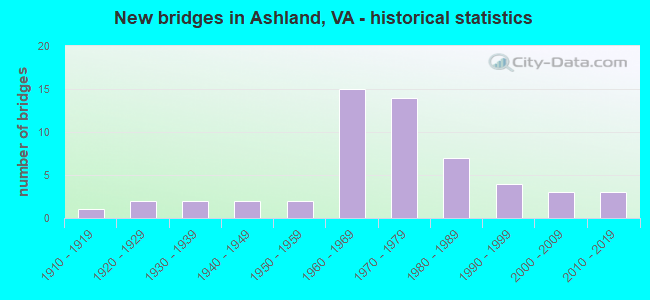
- New bridges - historical statistics
- 11910-1919
- 21920-1929
- 21930-1939
- 21940-1949
- 21950-1959
- 151960-1969
- 141970-1979
- 71980-1989
- 41990-1999
- 32000-2009
- 32010-2019

- Reconstructed bridges - Historical Statistics
- 11960-1969
- 31970-1979
- 11980-1989
- 11990-1999
- 02000-2009
- 32010-2019


- Bridge Condition - Deck
- 4.9%Very good
- 36.6%Good
- 36.6%Satisfactory
- 22.0%Fair

- Bridge Condition - Superstructure
- 4.9%Very good
- 26.8%Good
- 29.3%Satisfactory
- 34.1%Fair
- 4.9%Poor

- Bridge Condition - Substructure
- 26.8%Good
- 41.5%Satisfactory
- 31.7%Fair

- Bridge Condition - Channel
- 8.3%Very good
- 29.2%Good
- 33.3%Satisfactory
- 16.7%Fair
- 12.5%Poor
Find on map >> Show street view
Structure Number: 27602, Location: .12 OLD OAKLD .05 OAKVALE (Lat: 37.497197, Lng: -77.387694), Route carried "on" structure: County highway 77180, Year Built: 1998, Status: Open, Structure Length: 0.76m (2.49ft), Average Daily Traffic: 2,782 (year 2020), Truck Traffic: 3%, Average Future Daily Traffic: 3,895 (year 2040), Design Load: HS 20+Mod, Features Intersected: ALMOND CREEK, Facility Carried by Structure: OAKLAND ROAD
Minimum Vertical Clearance: 30+ m (98+ ft), Kilometerpoint: 1.577, Lanes on structure: 2, Owner: County Highway Agency, Approaching Roadway Width: 7.3m (24.0ft), Material/Design: Concrete, Design/Construction: Culvert, Number Of Spans In Main Unit: 3, Length of Maximum Span: 2.4m (7.9ft)
Condition: Channel: Satisfactory, Culverts: Satisfactory, Operating Rating: 89.8 metric tons, Method Used To Determine Operating Rating: Field evaluation and documented engineering judgment, Inventory Rating: 89.8 metric tons, Method Used To Determine Inventory Rating: Field evaluation and documented engineering judgment, Structural Evaluation: Equal to present minimum criteria, Waterway Adequacy: Superior to present desirable criteria, Approach Roadway Alignment: Equal to present desirable criteria, Designated Inspection Frequency: Every 24 months, Inspection Date: July 2021
Find on map >> Show street view
Structure Number: 28055, Location: 0.85 FR 802 & 0.46 TO 1 (Lat: 37.727050, Lng: -77.462700), Route carried "on" structure: State highway 782, Year Built: 2008, Status: Open, Structure Length: 1.68m (5.51ft), Average Daily Traffic: 1,200 (year 2017), Average Future Daily Traffic: 1,500 (year 2022), Design Load: HS 20+Mod, Features Intersected: LICKINGHOLE CREEK, Facility Carried by Structure: LAKERIDGE PARKWAY
Minimum Vertical Clearance: 30+ m (98+ ft), Kilometerpoint: 0.000, Lanes on structure: 4, Owner: State Highway Agency, Approaching Roadway Width: 12.2m (40.0ft), Skew: 2 degrees, Material/Design: Concrete, Design/Construction: Culvert, Number Of Spans In Main Unit: 4, Length of Maximum Span: 3.7m (12.1ft)
Condition: Channel: Satisfactory, Culverts: Satisfactory, Operating Rating: 54.4 metric tons, Method Used To Determine Operating Rating: Field evaluation and documented engineering judgment, Inventory Rating: 32.7 metric tons, Method Used To Determine Inventory Rating: Field evaluation and documented engineering judgment, Structural Evaluation: Equal to present minimum criteria, Waterway Adequacy: Equal to present minimum criteria, Approach Roadway Alignment: Equal to present minimum criteria, Designated Inspection Frequency: Every 24 months, Inspection Date: January 2021
Find on map >> Show street view
Structure Number: 29221, Location: .2 mi to 725&.5 mi fr 738 (Lat: 37.825606, Lng: -77.457797), Route carried "on" structure: County highway 689, Year Built: 2015, Status: Open, Structure Length: 2.74m (8.99ft), Average Daily Traffic: 184 (year 2017), Average Future Daily Traffic: 219 (year 2040), Design Load: HS 20+Mod, Features Intersected: LITTLE RIVER, Facility Carried by Structure: TAYLORSVILLE ROAD
Minimum Vertical Clearance: 30+ m (98+ ft), Kilometerpoint: 0.000, Lanes on structure: 2, Owner: State Highway Agency, Approaching Roadway Width: 7.0m (23.0ft), Material/Design: Steel, Design/Construction: Truss - Thru, Number Of Spans In Main Unit: 1, Length of Maximum Span: 26.6m (87.3ft), Curb-To-Curb Width: 7.0m (23.0ft), Out-to-Out Width: 7.5m (24.6ft)
Condition: Deck: Good, Superstructure: Good, Substructure: Good, Channel: Satisfactory, Operating Rating: 56.6 metric tons, Method Used To Determine Operating Rating: Load Factor (LF), Inventory Rating: 33.9 metric tons, Method Used To Determine Inventory Rating: Load Factor (LF), Structural Evaluation: Better than present minimum criteria, Deck Geometry: High priority of corrective action, Waterway Adequacy: Better than present minimum criteria, Approach Roadway Alignment: Superior to present desirable criteria, Designated Inspection Frequency: Every 12 months, Critical Feature Inspection Frequency: Every 12 months, Inspection Date: August 2021, Critical Feature Inspection Date: August 2021, Deck Structure Type: Concrete Cast-file-Place, Wearing Surface/Protective System: Wearing Surface: Monolithic Concrete, Deck Protection: Galvanized Reinforcing
Find on map >> Show street view
Structure Number: 29524, Location: 0.4 MI FR RTE 657 (Lat: 37.721447, Lng: -77.449425), Route carried "on" structure: County highway 802, Year Built: 2016, Status: Open, Structure Length: 7.33m (24.05ft), Average Daily Traffic: 12,317 (year 2020), Truck Traffic: 9%, Average Future Daily Traffic: 17,244 (year 2040), Design Load: HL 93, Features Intersected: I-95, Facility Carried by Structure: LEWISTOWN ROAD
Minimum Vertical Clearance: 30+ m (98+ ft), Kilometerpoint: 1.416, Lanes on structure: 4, Lanes under structure: 6, Owner: State Highway Agency, Approaching Roadway Width: 25.0m (82.0ft), Skew: 22 degrees, Material/Design: Steel, Design/Construction: Stringer/Multi-beam, Number Of Spans In Main Unit: 2, Length of Maximum Span: 35.9m (117.8ft), Curb-To-Curb Width: 25.0m (82.0ft), Out-to-Out Width: 26.0m (85.3ft)
Condition: Deck: Good, Superstructure: Good, Substructure: Good, Operating Rating: 77.6 metric tons, Method Used To Determine Operating Rating: Load and Resistance Factor (LRFR), Inventory Rating: 59.9 metric tons, Method Used To Determine Inventory Rating: Load and Resistance Factor (LRFR), Structural Evaluation: Better than present minimum criteria, Deck Geometry: Superior to present desirable criteria, Underclear: Superior to present desirable criteria, Approach Roadway Alignment: Equal to present minimum criteria, Designated Inspection Frequency: Every 24 months, Inspection Date: December 2021, Deck Structure Type: Concrete Cast-file-Place, Wearing Surface/Protective System: Wearing Surface: Monolithic Concrete, Deck Protection: Other Coated Reinforcing
Find on map >> Show street view
Structure Number: 9371, Location: 0.21 fr 725 & 0.49 to 688 (Lat: 37.845350, Lng: -77.452847), Route carried "under" structure: Interstate 95, Year Built: 1963, Structure Length: 0. m, Average Daily Traffic: 90,899 (year 2008), Truck Traffic: 7%, Features Intersected: RTE I 95, Facility Carried by Structure: WBL KINGS DOMINION
Minimum Vertical Clearance: 5.39m (17.68ft), Kilometerpoint: 157.923, Lanes on structure: 2, Lanes under structure: 7, Material/Design: Steel, Design/Construction: Stringer/Multi-beam, Length of Maximum Span: 21.6m (70.9ft)
Find on map >> Show street view
Structure Number: 9374, Location: 0.49 TO 688 & 0.21 FR 725 (Lat: 37.845225, Lng: -77.452831), Route carried "under" structure: Interstate 95, Year Built: 1976, Structure Length: 0. m, Average Daily Traffic: 90,899 (year 2008), Truck Traffic: 7%, Features Intersected: RTE I 95, Facility Carried by Structure: EBL KINGS DOMINION
Minimum Vertical Clearance: 5.26m (17.26ft), Kilometerpoint: 157.907, Lanes on structure: 2, Lanes under structure: 7, Material/Design: Steel continuous, Design/Construction: Stringer/Multi-beam, Length of Maximum Span: 21.9m (71.9ft)
Find on map >> Show street view
Structure Number: 9376, Location: 0.13 TO I 95 SBL (Lat: 37.844767, Lng: -77.455256), Route carried "under" structure: Ramp Interstate 95, Year Built: 1976, Structure Length: 0. m, Average Daily Traffic: 3,000 (year 1994), Features Intersected: ROUTE 0095 RAMP A, Facility Carried by Structure: KINGS DOMINION BVD
Minimum Vertical Clearance: 4.85m (15.91ft), Kilometerpoint: 0.000, Lanes on structure: 2, Lanes under structure: 2, Material/Design: Steel, Design/Construction: Stringer/Multi-beam, Length of Maximum Span: 23.8m (78.1ft)
Find on map >> Show street view
Structure Number: 9388, Location: 0.26 TO 656 &0.20ECL ASHL (Lat: 37.759397, Lng: -77.459728), Route carried "under" structure: Interstate 95, Year Built: 1961, Structure Length: 0. m, Average Daily Traffic: 92,000 (year 2020), Truck Traffic: 7%, Features Intersected: INTERSTATE 95, Facility Carried by Structure: PATRICK HENRY HWY
Minimum Vertical Clearance: 5.39m (17.68ft), Kilometerpoint: 148.350, Lanes on structure: 7, Lanes under structure: 7, Material/Design: Steel continuous, Design/Construction: Stringer/Multi-beam, Length of Maximum Span: 33.2m (108.9ft)
Find on map >> Show street view
Structure Number: 9406, Location: 0.4 TO I 95 SBL & .05 DE (Lat: 37.842275, Lng: -77.451900), Route carried "under" structure: Interstate 95, Year Built: 1976, Structure Length: 0. m, Average Daily Traffic: 108,000 (year 2019), Truck Traffic: 12%, Features Intersected: I-95 & F-099
Minimum Vertical Clearance: 5.82m (19.09ft), Kilometerpoint: 157.875, Lanes on structure: 3, Lanes under structure: 8, Material/Design: Steel continuous, Design/Construction: Stringer/Multi-beam, Length of Maximum Span: 48.8m (160.1ft)
Find on map >> Show street view
Structure Number: 9522, Location: 0.45 TO 641 & .50 TO 793 (Lat: 37.798672, Lng: -77.460156), Route carried "under" structure: Interstate 95, Year Built: 1982, Structure Length: 0. m, Average Daily Traffic: 55,000 (year 2019), Truck Traffic: 12%, Features Intersected: NBL ROUTE I-95, Facility Carried by Structure: HICKORY HILL ROAD
Minimum Vertical Clearance: 5.11m (16.77ft), Kilometerpoint: 152.952, Lanes on structure: 2, Lanes under structure: 3, Material/Design: Steel, Design/Construction: Stringer/Multi-beam, Length of Maximum Span: 39.5m (129.6ft)
Find on map >> Show street view
Structure Number: 9524, Location: .40 FR 641 & .55 TO 793 W (Lat: 37.799178, Lng: -77.461439), Route carried "under" structure: Interstate 95, Year Built: 1982, Structure Length: 0. m, Average Daily Traffic: 56,000 (year 2019), Truck Traffic: 13%, Features Intersected: SBL ROUTE I-95, Facility Carried by Structure: HICKORY HILL ROAD
Minimum Vertical Clearance: 5.11m (16.77ft), Kilometerpoint: 152.952, Lanes on structure: 2, Lanes under structure: 3, Material/Design: Steel, Design/Construction: Stringer/Multi-beam, Length of Maximum Span: 39.5m (129.6ft)
Find on map >> Show street view
Structure Number: 9536, Location: 0.40 TO 808 & 0.10 TO 659 (Lat: 37.736242, Lng: -77.453469), Route carried "under" structure: Interstate 95, Year Built: 1961, Structure Length: 0. m, Average Daily Traffic: 119,000 (year 2019), Truck Traffic: 12%, Features Intersected: I-95, Facility Carried by Structure: ASHCAKE ROAD
Minimum Vertical Clearance: 4.67m (15.32ft), Kilometerpoint: 145.309, Lanes on structure: 2, Lanes under structure: 6, Material/Design: Steel, Design/Construction: Stringer/Multi-beam, Length of Maximum Span: 26.9m (88.3ft)
Find on map >> Show street view
Structure Number: 9573, Location: .20 TO 1 & .57 WoodsideLn (Lat: 37.776131, Lng: -77.462519), Route carried "under" structure: Interstate 95, Year Built: 1963, Structure Length: 0. m, Average Daily Traffic: 100,635 (year 2008), Truck Traffic: 7%, Features Intersected: RTE I 95, Facility Carried by Structure: JAMESTOWN ROAD
Minimum Vertical Clearance: 5.26m (17.26ft), Kilometerpoint: 150.442, Lanes on structure: 2, Lanes under structure: 6, Material/Design: Steel, Design/Construction: Stringer/Multi-beam, Length of Maximum Span: 23.5m (77.1ft)
Find on map >> Show street view
Structure Number: 959, Location: 0.10 TO 689 & 3.35 TO 646 (Lat: 37.817189, Lng: -77.458139), Route carried "under" structure: Interstate 95, Year Built: 1982, Structure Length: 0. m, Average Daily Traffic: 111,000 (year 2017), Truck Traffic: 13%, Features Intersected: RTE I 95, Facility Carried by Structure: OLD RIDGE ROAD
Minimum Vertical Clearance: 5.66m (18.57ft), Kilometerpoint: 155.043, Lanes on structure: 2, Lanes under structure: 6, Material/Design: Steel continuous, Design/Construction: Stringer/Multi-beam, Length of Maximum Span: 33.0m (108.3ft)
Find on map >> Show street view
Structure Number: 29524, Location: 0.4 MI FR RTE 657 (Lat: 37.721447, Lng: -77.449425), Route carried "under" structure: Interstate 95, Year Built: 2016, Structure Length: 0. m, Average Daily Traffic: 58,500 (year 2018), Truck Traffic: 12%, Features Intersected: I-95, Facility Carried by Structure: LEWISTOWN ROAD
Minimum Vertical Clearance: 5.46m (17.91ft), Kilometerpoint: 144.358, Lanes on structure: 4, Lanes under structure: 6, Material/Design: Steel, Design/Construction: Stringer/Multi-beam, Length of Maximum Span: 35.9m (117.8ft)