Bridge Statistics for Athens-Clarke County, Georgia (GA)
Condition, Traffic, Stress, Structural Evaluation, Project Costs
- National Bridge Inventory (NBI) Statistics
- 191Number of bridges
- 2,339ft / 713mTotal length
- $232,796,000Total costs
- 3,023,050Total average daily traffic
- 102,619Total average daily truck traffic
- National Bridge Inventory (NBI) Registered Bridges for Athens-Clarke County
- No street view available for this location
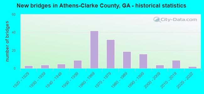
- New bridges - historical statistics
- 31920-1929
- 41930-1939
- 51940-1949
- 91950-1959
- 421960-1969
- 321970-1979
- 191980-1989
- 161990-1999
- 42000-2009
- 92010-2019
- 22020-2022

- Reconstructed bridges - Historical Statistics
- 11920-1929
- 01930-1939
- 01940-1949
- 01950-1959
- 01960-1969
- 11970-1979
- 131980-1989
- 91990-1999
- 22000-2009
- 12010-2019


- Bridge Condition - Deck
- 2.0%Very good
- 67.0%Good
- 28.0%Satisfactory
- 2.0%Fair
- 1.0%Poor

- Bridge Condition - Superstructure
- 19.0%Very good
- 75.0%Good
- 6.0%Satisfactory

- Bridge Condition - Substructure
- 3.0%Very good
- 85.0%Good
- 11.0%Satisfactory
- 1.0%Fair

- Bridge Condition - Channel
- 3.2%Excellent
- 31.2%Very good
- 23.7%Good
- 31.2%Satisfactory
- 10.8%Fair

- Bridge Condition - Culverts
- 4.4%Very good
- 73.3%Good
- 20.0%Satisfactory
- 2.2%Fair
Find on map >> Show street view
Structure Number: 2195022, Location: 5 MI E OF WATKINSVILLE (Lat: 33.848308, Lng: -83.332789), Route carried "on" structure: County highway 158, Year Built: 1961, Status: Open, Structure Length: 0.98m (3.22ft), Average Daily Traffic: 490 (year 2012), Truck Traffic: 1%, Average Future Daily Traffic: 735 (year 2032), Design Load: H 15, Features Intersected: PORTERS CREEK, Facility Carried by Structure: MCREE MILL ROAD
Minimum Vertical Clearance: 30+ m (98+ ft), Kilometerpoint: 6.437, Lanes on structure: 2, Base Highway Network: Yes, Owner: County Highway Agency, Approaching Roadway Width: 6.1m (20.0ft), Material/Design: Concrete, Design/Construction: Culvert, Number Of Spans In Main Unit: 3, Length of Maximum Span: 3.0m (9.8ft)
Condition: Channel: Good, Culverts: Good, Structural Evaluation: Better than present minimum criteria, Waterway Adequacy: Equal to present desirable criteria, Approach Roadway Alignment: Equal to present desirable criteria, Designated Inspection Frequency: Every 24 months, Inspection Date: August 2021, Bridge Improvement Cost: $125,000, Roadway Improvement Cost: $13,000, Total Project Cost: $188,000
Find on map >> Show street view
Structure Number: 2195024, Location: 7 MI E OF BISHOP (Lat: 33.811319, Lng: -83.315819), Route carried "on" structure: County highway 161, Year Built: 1984, Status: Open, Structure Length: 0.88m (2.89ft), Average Daily Traffic: 490 (year 2012), Truck Traffic: 1%, Average Future Daily Traffic: 735 (year 2032), Design Load: HS 20+Mod, Features Intersected: WILD CAT CREEK, Facility Carried by Structure: OLIVER BRIDGE ROAD
Minimum Vertical Clearance: 30+ m (98+ ft), Kilometerpoint: 3.219, Lanes on structure: 2, Base Highway Network: Yes, Owner: County Highway Agency, Approaching Roadway Width: 6.1m (20.0ft), Material/Design: Concrete, Design/Construction: Culvert, Number Of Spans In Main Unit: 3, Length of Maximum Span: 2.7m (8.9ft)
Condition: Channel: Satisfactory, Culverts: Good, Operating Rating: 55.3 metric tons, Method Used To Determine Operating Rating: Field evaluation and documented engineering judgment, Inventory Rating: 32.6 metric tons, Method Used To Determine Inventory Rating: Field evaluation and documented engineering judgment, Structural Evaluation: Better than present minimum criteria, Waterway Adequacy: Equal to present desirable criteria, Approach Roadway Alignment: Better than present minimum criteria, Designated Inspection Frequency: Every 24 months, Inspection Date: August 2021, Bridge Improvement Cost: $113,000, Roadway Improvement Cost: $11,000, Total Project Cost: $170,000
Find on map >> Show street view
Structure Number: 2195027, Location: 5 MI E OF WATKINSVILLE (Lat: 33.855619, Lng: -83.326758), Route carried "on" structure: County highway 262, Year Built: 1980, Status: Open, Structure Length: 7.32m (24.02ft), Average Daily Traffic: 1,130 (year 2012), Truck Traffic: 1%, Average Future Daily Traffic: 1,695 (year 2032), Design Load: HS 15, Features Intersected: OCONEE RIVER, Facility Carried by Structure: BARNETT SHOALS RD
Minimum Vertical Clearance: 30+ m (98+ ft), Kilometerpoint: 8.047, Lanes on structure: 2, Base Highway Network: Yes, Owner: County Highway Agency, Approaching Roadway Width: 6.7m (22.0ft), Material/Design: Prestressed concrete, Design/Construction: Stringer/Multi-beam, Number Of Spans In Main Unit: 4, Length of Maximum Span: 18.3m (60.0ft), Curb-To-Curb Width: 9.8m (32.2ft), Out-to-Out Width: 10.7m (35.1ft)
Condition: Deck: Good, Superstructure: Good, Substructure: Good, Channel: Satisfactory, Operating Rating: 47.1 metric tons, Method Used To Determine Operating Rating: Load Factor (LF), Inventory Rating: 28.1 metric tons, Method Used To Determine Inventory Rating: Load Factor (LF), Structural Evaluation: Better than present minimum criteria, Deck Geometry: Somewhat better than minimum adequacy, Waterway Adequacy: Equal to present desirable criteria, Approach Roadway Alignment: Equal to present minimum criteria, Designated Inspection Frequency: Every 24 months, Underwater Inspection Frequency: Every 60 months, Inspection Date: August 2021, Underwater Inspection Date: June 2021, Deck Structure Type: Concrete Cast-file-Place
Find on map >> Show street view
Structure Number: 2195028, Location: 6.3 MI E OF WATKINSVILLE (Lat: 33.850369, Lng: -83.299358), Route carried "on" structure: County highway 262, Year Built: 1980, Status: Open, Structure Length: 0.98m (3.22ft), Average Daily Traffic: 1,120 (year 2012), Truck Traffic: 1%, Average Future Daily Traffic: 1,680 (year 2032), Design Load: HS 20+Mod, Features Intersected: SHOAL CREEK, Facility Carried by Structure: BARNETT SHOALS RD
Minimum Vertical Clearance: 30+ m (98+ ft), Kilometerpoint: 11.265, Lanes on structure: 2, Base Highway Network: Yes, Owner: County Highway Agency, Approaching Roadway Width: 6.7m (22.0ft), Material/Design: Concrete, Design/Construction: Culvert, Number Of Spans In Main Unit: 3, Length of Maximum Span: 3.0m (9.8ft)
Condition: Channel: Satisfactory, Culverts: Good, Structural Evaluation: Better than present minimum criteria, Waterway Adequacy: Superior to present desirable criteria, Approach Roadway Alignment: Equal to present desirable criteria, Designated Inspection Frequency: Every 24 months, Inspection Date: August 2021, Bridge Improvement Cost: $125,000, Roadway Improvement Cost: $13,000, Total Project Cost: $188,000
Find on map >> Show street view
Structure Number: 2195035, Location: 4.5 MI NW OF WATKINSVILLE (Lat: 33.923158, Lng: -83.440139), Route carried "on" structure: County highway 344, Year Built: 1999, Status: Open, Structure Length: 5.49m (18.01ft), Average Daily Traffic: 28,860 (year 2012), Truck Traffic: 1%, Average Future Daily Traffic: 43,290 (year 2032), Design Load: HS 20+Mod, Features Intersected: McNUTT CREEK, Facility Carried by Structure: EPPS BRIDGE PARKWA
Minimum Vertical Clearance: 30+ m (98+ ft), Kilometerpoint: 1.609, Lanes on structure: 4, Base Highway Network: Yes, Owner: County Highway Agency, Approaching Roadway Width: 19.8m (65.0ft), Skew: 20 degrees, Material/Design: Prestressed concrete, Design/Construction: Stringer/Multi-beam, Number Of Spans In Main Unit: 3, Length of Maximum Span: 18.3m (60.0ft), Curb or Sidewalk Widths: Left: 1.8m (5.9ft), Right: 1.8m (5.9ft), Curb-To-Curb Width: 25.1m (82.3ft), Out-to-Out Width: 29.5m (96.8ft)
Condition: Deck: Good, Superstructure: Very good, Substructure: Good, Channel: Very good, Operating Rating: 53.5 metric tons, Method Used To Determine Operating Rating: Allowable Stress (AS), Inventory Rating: 31.7 metric tons, Method Used To Determine Inventory Rating: Allowable Stress (AS), Structural Evaluation: Better than present minimum criteria, Deck Geometry: Superior to present desirable criteria, Waterway Adequacy: Equal to present desirable criteria, Approach Roadway Alignment: Equal to present desirable criteria, Designated Inspection Frequency: Every 24 months, Inspection Date: August 2021, Bridge Improvement Cost: $1,087,000, Roadway Improvement Cost: $109,000, Total Project Cost: $1,630,000, Deck Structure Type: Concrete Cast-file-Place
Find on map >> Show street view
Structure Number: 2195036, Location: 3.6 MI NNE OF WATKINSVILL (Lat: 33.914919, Lng: -83.405900), Route carried "on" structure: Ramp US 29, Year Built: 1999, Status: Open, Structure Length: 1.37m (4.49ft), Average Daily Traffic: 42,200 (year 2012), Truck Traffic: 1%, Average Future Daily Traffic: 63,300 (year 2032), Design Load: HS 20+Mod, Features Intersected: MCNUTT CREEK
Minimum Vertical Clearance: 30+ m (98+ ft), Kilometerpoint: 17.703, Lanes on structure: 1, Base Highway Network: Yes, Owner: State Highway Agency, Approaching Roadway Width: 7.6m (24.9ft), Skew: 1 degrees, Material/Design: Concrete, Design/Construction: Culvert, Number Of Spans In Main Unit: 4, Length of Maximum Span: 3.0m (9.8ft)
Condition: Channel: Very good, Culverts: Good, Structural Evaluation: Better than present minimum criteria, Waterway Adequacy: Superior to present desirable criteria, Approach Roadway Alignment: Equal to present desirable criteria, Designated Inspection Frequency: Every 24 months, Inspection Date: August 2021, Bridge Improvement Cost: $128,000, Roadway Improvement Cost: $13,000, Total Project Cost: $192,000
Find on map >> Show street view
Structure Number: 2195037, Location: 3.3 MI N OF WATKINSVILLE (Lat: 33.911019, Lng: -83.404558), Route carried "on" structure: US 129, Year Built: 1999, Status: Open, Structure Length: 10.97m (35.99ft), Average Daily Traffic: 23,560 (year 2012), Truck Traffic: 6%, Average Future Daily Traffic: 35,340 (year 2032), Design Load: HS 20+Mod, Features Intersected: BARBER CREEK
Minimum Vertical Clearance: 30+ m (98+ ft), Kilometerpoint: 24.140, Lanes on structure: 4, Base Highway Network: Yes, Owner: State Highway Agency, Approaching Roadway Width: 18.3m (60.0ft), Skew: 20 degrees, Material/Design: Prestressed concrete, Design/Construction: Stringer/Multi-beam, Number Of Spans In Main Unit: 4, Length of Maximum Span: 27.4m (89.9ft), Curb-To-Curb Width: 26.8m (87.9ft), Out-to-Out Width: 27.8m (91.2ft)
Condition: Deck: Good, Superstructure: Good, Substructure: Good, Channel: Very good, Operating Rating: 68.9 metric tons, Method Used To Determine Operating Rating: Load Factor (LF), Inventory Rating: 35.3 metric tons, Method Used To Determine Inventory Rating: Load Factor (LF), Structural Evaluation: Better than present minimum criteria, Deck Geometry: Superior to present desirable criteria, Waterway Adequacy: Equal to present desirable criteria, Approach Roadway Alignment: Equal to present desirable criteria, Designated Inspection Frequency: Every 24 months, Inspection Date: August 2021, Bridge Improvement Cost: $2,174,000, Roadway Improvement Cost: $217,000, Total Project Cost: $3,261,000, Deck Structure Type: Concrete Cast-file-Place
Find on map >> Show street view
Structure Number: 2195038, Location: 3.5 MI N OF WATKINSVILLE (Lat: 33.913628, Lng: -83.404839), Route carried "on" structure: US 129, Year Built: 1999, Status: Open, Structure Length: 14.02m (46.00ft), Average Daily Traffic: 6,520 (year 2012), Truck Traffic: 1%, Average Future Daily Traffic: 9,780 (year 2032), Design Load: HS 20+Mod, Features Intersected: McNUTT CREEK
Minimum Vertical Clearance: 30+ m (98+ ft), Kilometerpoint: 24.140, Lanes on structure: 4, Base Highway Network: Yes, Owner: State Highway Agency, Approaching Roadway Width: 18.3m (60.0ft), Skew: 20 degrees, Material/Design: Prestressed concrete, Design/Construction: Stringer/Multi-beam, Number Of Spans In Main Unit: 4, Length of Maximum Span: 35.1m (115.2ft), Curb-To-Curb Width: 27.4m (89.9ft), Out-to-Out Width: 28.3m (92.8ft)
Condition: Deck: Good, Superstructure: Good, Substructure: Good, Channel: Satisfactory, Operating Rating: 61.6 metric tons, Method Used To Determine Operating Rating: Load Factor (LF), Inventory Rating: 36.2 metric tons, Method Used To Determine Inventory Rating: Load Factor (LF), Structural Evaluation: Better than present minimum criteria, Deck Geometry: Superior to present desirable criteria, Waterway Adequacy: Equal to present desirable criteria, Approach Roadway Alignment: Equal to present desirable criteria, Designated Inspection Frequency: Every 24 months, Inspection Date: August 2021, Bridge Improvement Cost: $2,778,000, Roadway Improvement Cost: $278,000, Total Project Cost: $4,166,000, Deck Structure Type: Concrete Cast-file-Place
Find on map >> Show street view
Structure Number: 2195046, Location: 3.5 MI E OF EASTVILLE (Lat: 33.916586, Lng: -83.459675), Route carried "on" structure: County highway 929, Year Built: 2011, Status: Open, Structure Length: 7.62m (25.00ft), Average Daily Traffic: 16,600 (year 2011), Truck Traffic: 3%, Average Future Daily Traffic: 26,700 (year 2031), Design Load: HS 20+Mod, Features Intersected: SR 10 LOOP, Facility Carried by Structure: OCONEE CONNECTOR
Minimum Vertical Clearance: 30+ m (98+ ft), Kilometerpoint: 1.609, Lanes on structure: 5, Lanes under structure: 4, Base Highway Network: Yes, Owner: State Highway Agency, Approaching Roadway Width: 23.2m (76.1ft), Skew: 20 degrees, Material/Design: Prestressed concrete, Design/Construction: Stringer/Multi-beam, Number Of Spans In Main Unit: 4, Length of Maximum Span: 25.9m (85.0ft), Curb or Sidewalk Widths: Left: 1.8m (5.9ft), Right: 1.8m (5.9ft), Curb-To-Curb Width: 24.4m (80.1ft), Out-to-Out Width: 28.8m (94.5ft)
Condition: Deck: Good, Superstructure: Very good, Substructure: Good, Operating Rating: 53.5 metric tons, Method Used To Determine Operating Rating: Load Factor (LF), Inventory Rating: 31.7 metric tons, Method Used To Determine Inventory Rating: Load Factor (LF), Structural Evaluation: Better than present minimum criteria, Deck Geometry: Superior to present desirable criteria, Underclear: Better than present minimum criteria, Approach Roadway Alignment: Equal to present desirable criteria, Designated Inspection Frequency: Every 24 months, Inspection Date: August 2021, Bridge Improvement Cost: $1,776,000, Roadway Improvement Cost: $178,000, Total Project Cost: $2,664,000, Deck Structure Type: Concrete Cast-file-Place
Find on map >> Show street view
Structure Number: 2195047, Location: 3 MI NE OF EASTVILLE (Lat: 33.902108, Lng: -83.463308), Route carried "on" structure: County highway 1267, Year Built: 2015, Status: Open, Structure Length: 3.96m (12.99ft), Average Daily Traffic: 7,590 (year 2014), Truck Traffic: 1%, Average Future Daily Traffic: 11,385 (year 2034), Design Load: HS 20+Mod, Features Intersected: BARBER CREEK, Facility Carried by Structure: MARS HILL ROAD
Minimum Vertical Clearance: 30+ m (98+ ft), Kilometerpoint: 6.437, Lanes on structure: 4, Base Highway Network: Yes, Owner: County Highway Agency, Approaching Roadway Width: 7.3m (24.0ft), Skew: 21 degrees, Material/Design: Prestressed concrete, Design/Construction: Stringer/Multi-beam, Number Of Spans In Main Unit: 1, Length of Maximum Span: 39.6m (129.9ft), Curb or Sidewalk Widths: Left: 1.8m (5.9ft), Right: 1.8m (5.9ft), Curb-To-Curb Width: 24.4m (80.1ft), Out-to-Out Width: 28.8m (94.5ft)
Condition: Deck: Good, Superstructure: Very good, Substructure: Good, Channel: Very good, Inventory Rating: 53.5 metric tons, Method Used To Determine Inventory Rating: Load Factor (LF), Structural Evaluation: Better than present minimum criteria, Deck Geometry: Superior to present desirable criteria, Waterway Adequacy: Equal to present desirable criteria, Approach Roadway Alignment: Equal to present desirable criteria, Length Of Structure Improvement: 4.75m (15.58ft), Designated Inspection Frequency: Every 24 months, Inspection Date: August 2021, Bridge Improvement Cost: $11,544,000, Roadway Improvement Cost: $1,154,000, Total Project Cost: $17,316,000 ( Estimate for 2016), Deck Structure Type: Concrete Cast-file-Place
Find on map >> Show street view
Structure Number: 2195048, Location: 3.5 MI NW OF WATKINSVILLE (Lat: 33.889728, Lng: -83.457208), Route carried "on" structure: County highway 1267, Year Built: 2017, Status: Open, Structure Length: 0.79m (2.59ft), Average Daily Traffic: 12,550 (year 2012), Truck Traffic: 1%, Average Future Daily Traffic: 18,825 (year 2032), Design Load: HS 20+Mod, Features Intersected: BARBER CREEK TRIB, Facility Carried by Structure: MARS HILL ROAD
Minimum Vertical Clearance: 30+ m (98+ ft), Kilometerpoint: 3.219, Lanes on structure: 2, Base Highway Network: Yes, Owner: County Highway Agency, Approaching Roadway Width: 7.3m (24.0ft), Material/Design: Concrete, Design/Construction: Culvert, Number Of Spans In Main Unit: 3, Length of Maximum Span: 2.4m (7.9ft)
Condition: Channel: Very good, Culverts: Good, Structural Evaluation: Better than present minimum criteria, Waterway Adequacy: Equal to present desirable criteria, Approach Roadway Alignment: Equal to present desirable criteria, Length Of Structure Improvement: 0.94m (3.08ft), Designated Inspection Frequency: Every 24 months, Inspection Date: August 2021, Bridge Improvement Cost: $2,294,000, Roadway Improvement Cost: $229,000, Total Project Cost: $3,441,000 ( Estimate for 2017)
Find on map >> Show street view
Structure Number: 2210001, Location: 1.4 MI W OF ARNOLDSVILLE (Lat: 33.898778, Lng: -83.240658), Route carried "on" structure: US 78, Year Built: 1920, Year Reconstructed: 1932, Status: Open, Structure Length: 0.64m (2.10ft), Average Daily Traffic: 8,630 (year 2011), Truck Traffic: 14%, Average Future Daily Traffic: 12,945 (year 2031), Design Load: H 15, Features Intersected: MOSS CREEK
Minimum Vertical Clearance: 30+ m (98+ ft), Kilometerpoint: 0.000, Lanes on structure: 2, Base Highway Network: Yes, Owner: State Highway Agency, Approaching Roadway Width: 7.3m (24.0ft), Material/Design: Concrete, Design/Construction: Culvert, Number Of Spans In Main Unit: 1, Length of Maximum Span: 6.1m (20.0ft), Curb-To-Curb Width: 9.7m (31.8ft), Out-to-Out Width: 10.6m (34.8ft)
Condition: Channel: Good, Culverts: Satisfactory, Operating Rating: 41.7 metric tons, Method Used To Determine Operating Rating: Field evaluation and documented engineering judgment, Inventory Rating: 24.4 metric tons, Method Used To Determine Inventory Rating: Field evaluation and documented engineering judgment, Structural Evaluation: Equal to present minimum criteria, Deck Geometry: High priority of corrective action, Waterway Adequacy: Equal to present desirable criteria, Approach Roadway Alignment: Equal to present desirable criteria, Designated Inspection Frequency: Every 24 months, Inspection Date: November 2020, Bridge Improvement Cost: $82,000, Roadway Improvement Cost: $8,000, Total Project Cost: $123,000
Find on map >> Show street view
Structure Number: 2210015, Location: 5.1 MI SW OF ARNOLDSVILLE (Lat: 33.847239, Lng: -83.273119), Route carried "on" structure: County highway 1086, Year Built: 1959, Status: Posted for load, Structure Length: 4.11m (13.48ft), Average Daily Traffic: 1,140 (year 2011), Truck Traffic: 1%, Average Future Daily Traffic: 1,710 (year 2031), Design Load: H 15, Features Intersected: BIG CREEK, Facility Carried by Structure: GODFREY ROAD
Minimum Vertical Clearance: 30+ m (98+ ft), Kilometerpoint: 0.000, Lanes on structure: 2, Base Highway Network: Yes, Owner: County Highway Agency, Approaching Roadway Width: 6.4m (21.0ft), Material/Design: Concrete, Design/Construction: Tee Beam, Number Of Spans In Main Unit: 5, Length of Maximum Span: 8.2m (26.9ft), Curb or Sidewalk Widths: Left: 0.6m (2.0ft), Right: 0.6m (2.0ft), Curb-To-Curb Width: 7.3m (24.0ft), Out-to-Out Width: 9.2m (30.2ft)
Condition: Deck: Good, Superstructure: Good, Substructure: Good, Channel: Fair, Operating Rating: 32.6 metric tons, Method Used To Determine Operating Rating: Load Factor (LF), Inventory Rating: 19.0 metric tons, Method Used To Determine Inventory Rating: Load Factor (LF), Structural Evaluation: Somewhat better than minimum adequacy, Deck Geometry: Meets minimum limits, Waterway Adequacy: Equal to present desirable criteria, Approach Roadway Alignment: Equal to present desirable criteria, Bridge Posting: Required (Relationship of Operating Rating to Maximum Legal Load: 0.1 - 9.9% below), Length Of Structure Improvement: 10.55m (34.61ft), Designated Inspection Frequency: Every 24 months, Inspection Date: November 2020, Bridge Improvement Cost: $527,000, Roadway Improvement Cost: $53,000, Total Project Cost: $791,000, Deck Structure Type: Concrete Cast-file-Place
Find on map >> Show street view
Structure Number: 2210016, Location: 5.3 MI SW OF CRAWFORD (Lat: 33.833408, Lng: -83.230697), Route carried "on" structure: County highway 1086, Year Built: 1993, Status: Open, Structure Length: 2.10m (6.89ft), Average Daily Traffic: 60 (year 2011), Truck Traffic: 1%, Average Future Daily Traffic: 90 (year 2031), Features Intersected: BARROW CREEK, Facility Carried by Structure: HUTCHINS-WOLFSKIN
Minimum Vertical Clearance: 30+ m (98+ ft), Kilometerpoint: 4.828, Lanes on structure: 2, Base Highway Network: Yes, Owner: County Highway Agency, Approaching Roadway Width: 4.9m (16.1ft), Skew: 4 degrees, Material/Design: Concrete, Design/Construction: Culvert, Number Of Spans In Main Unit: 5, Length of Maximum Span: 4.0m (13.1ft)
Condition: Channel: Very good, Culverts: Satisfactory, Operating Rating: 55.3 metric tons, Method Used To Determine Operating Rating: Field evaluation and documented engineering judgment, Inventory Rating: 32.6 metric tons, Method Used To Determine Inventory Rating: Field evaluation and documented engineering judgment, Structural Evaluation: Equal to present minimum criteria, Waterway Adequacy: Equal to present desirable criteria, Approach Roadway Alignment: Equal to present desirable criteria, Designated Inspection Frequency: Every 24 months, Inspection Date: November 2020, Bridge Improvement Cost: $270,000, Roadway Improvement Cost: $27,000, Total Project Cost: $404,000
Find on map >> Show street view
Structure Number: 2215001, Location: 5.5 MI N OF ARNOLDSVILLE (Lat: 33.985878, Lng: -83.238839), Route carried "on" structure: County highway 50, Year Built: 1960, Status: Open, Structure Length: 0.73m (2.40ft), Average Daily Traffic: 2,210 (year 2011), Truck Traffic: 1%, Average Future Daily Traffic: 3,315 (year 2031), Design Load: H 15, Features Intersected: SULPHUR SPRING BR TRIB, Facility Carried by Structure: SMITHSONIA ROAD
Minimum Vertical Clearance: 30+ m (98+ ft), Kilometerpoint: 1.609, Lanes on structure: 2, Base Highway Network: Yes, Owner: County Highway Agency, Approaching Roadway Width: 6.1m (20.0ft), Skew: 3 degrees, Material/Design: Concrete, Design/Construction: Culvert, Number Of Spans In Main Unit: 2, Length of Maximum Span: 3.7m (12.1ft)
Condition: Channel: Fair, Culverts: Satisfactory, Operating Rating: 41.7 metric tons, Method Used To Determine Operating Rating: Field evaluation and documented engineering judgment, Inventory Rating: 24.4 metric tons, Method Used To Determine Inventory Rating: Field evaluation and documented engineering judgment, Structural Evaluation: Equal to present minimum criteria, Waterway Adequacy: Equal to present desirable criteria, Approach Roadway Alignment: Equal to present minimum criteria, Designated Inspection Frequency: Every 24 months, Inspection Date: October 2020, Bridge Improvement Cost: $94,000, Roadway Improvement Cost: $9,000, Total Project Cost: $141,000
Find on map >> Show street view
Structure Number: 2215002, Location: 6.4 MI N OF ARNOLDSVILLE (Lat: 33.996689, Lng: -83.236919), Route carried "on" structure: County highway 51, Year Built: 1984, Status: Open, Structure Length: 0.88m (2.89ft), Average Daily Traffic: 40 (year 2011), Truck Traffic: 1%, Average Future Daily Traffic: 60 (year 2031), Design Load: HS 20+Mod, Features Intersected: SULFUR SPRING BRANCH, Facility Carried by Structure: MELTON ROAD
Minimum Vertical Clearance: 30+ m (98+ ft), Kilometerpoint: 1.609, Lanes on structure: 2, Base Highway Network: Yes, Owner: County Highway Agency, Approaching Roadway Width: 6.1m (20.0ft), Material/Design: Concrete, Design/Construction: Culvert, Number Of Spans In Main Unit: 3, Length of Maximum Span: 2.7m (8.9ft)
Condition: Channel: Satisfactory, Culverts: Good, Operating Rating: 55.3 metric tons, Method Used To Determine Operating Rating: Field evaluation and documented engineering judgment, Inventory Rating: 32.6 metric tons, Method Used To Determine Inventory Rating: Field evaluation and documented engineering judgment, Structural Evaluation: Better than present minimum criteria, Waterway Adequacy: Better than present minimum criteria, Approach Roadway Alignment: Better than present minimum criteria, Designated Inspection Frequency: Every 24 months, Inspection Date: October 2020, Bridge Improvement Cost: $113,000, Roadway Improvement Cost: $11,000, Total Project Cost: $170,000
Find on map >> Show street view
Structure Number: 2215003, Location: 6.9 MI NW OF ARNOLDSVILLE (Lat: 33.999078, Lng: -83.258458), Route carried "on" structure: County highway 52, Year Built: 1960, Status: Open, Structure Length: 0.64m (2.10ft), Average Daily Traffic: 170 (year 2011), Truck Traffic: 1%, Average Future Daily Traffic: 255 (year 2031), Design Load: H 15, Features Intersected: SULFUR SPRING BRANCH, Facility Carried by Structure: LEM EDWARDS ROAD
Minimum Vertical Clearance: 30+ m (98+ ft), Kilometerpoint: 0.000, Lanes on structure: 2, Base Highway Network: Yes, Owner: County Highway Agency, Approaching Roadway Width: 6.4m (21.0ft), Material/Design: Concrete, Design/Construction: Culvert, Number Of Spans In Main Unit: 2, Length of Maximum Span: 3.0m (9.8ft)
Condition: Channel: Fair, Culverts: Satisfactory, Operating Rating: 41.7 metric tons, Method Used To Determine Operating Rating: Field evaluation and documented engineering judgment, Inventory Rating: 24.4 metric tons, Method Used To Determine Inventory Rating: Field evaluation and documented engineering judgment, Structural Evaluation: Equal to present minimum criteria, Waterway Adequacy: Equal to present minimum criteria, Approach Roadway Alignment: Better than present minimum criteria, Designated Inspection Frequency: Every 24 months, Inspection Date: October 2020, Bridge Improvement Cost: $82,000, Roadway Improvement Cost: $8,000, Total Project Cost: $123,000
Find on map >> Show street view
Structure Number: 2215021, Location: 5 MI SW OF ARNOLDSVILLE (Lat: 33.847758, Lng: -83.271419), Route carried "on" structure: County highway 81, Year Built: 1990, Status: Open, Structure Length: 1.31m (4.30ft), Average Daily Traffic: 70 (year 2011), Truck Traffic: 1%, Average Future Daily Traffic: 105 (year 2031), Design Load: HS 20+Mod, Features Intersected: MOSS CREEK, Facility Carried by Structure: DOUBLE BRIDGES RD
Minimum Vertical Clearance: 30+ m (98+ ft), Kilometerpoint: 0.000, Lanes on structure: 2, Base Highway Network: Yes, Owner: County Highway Agency, Approaching Roadway Width: 5.8m (19.0ft), Material/Design: Concrete, Design/Construction: Culvert, Number Of Spans In Main Unit: 4, Length of Maximum Span: 3.0m (9.8ft)
Condition: Channel: Good, Culverts: Satisfactory, Structural Evaluation: Equal to present minimum criteria, Waterway Adequacy: Equal to present desirable criteria, Approach Roadway Alignment: Equal to present desirable criteria, Designated Inspection Frequency: Every 24 months, Inspection Date: November 2020, Bridge Improvement Cost: $168,000, Roadway Improvement Cost: $17,000, Total Project Cost: $252,000
Find on map >> Show street view
Structure Number: 2215027, Location: 6.5 MI SW OF ARNOLDSVILLE (Lat: 33.822358, Lng: -83.271969), Route carried "on" structure: County highway 80, Year Built: 1997, Status: Posted for load, Structure Length: 3.60m (11.81ft), Average Daily Traffic: 20 (year 2011), Truck Traffic: 1%, Average Future Daily Traffic: 30 (year 2031), Design Load: H 15, Features Intersected: BIG CREEK, Facility Carried by Structure: WILSON ROAD
Minimum Vertical Clearance: 30+ m (98+ ft), Kilometerpoint: 3.219, Lanes on structure: 1, Base Highway Network: Yes, Owner: County Highway Agency, Approaching Roadway Width: 4.9m (16.1ft), Material/Design: Steel, Design/Construction: Stringer/Multi-beam, Number Of Spans In Main Unit: 3, Length of Maximum Span: 16.8m (55.1ft), Curb-To-Curb Width: 4.4m (14.4ft), Out-to-Out Width: 5.2m (17.1ft)
Condition: Deck: Good, Superstructure: Satisfactory, Substructure: Good, Channel: Very good, Operating Rating: 39.0 metric tons, Method Used To Determine Operating Rating: Load Factor (LF), Inventory Rating: 23.5 metric tons, Method Used To Determine Inventory Rating: Load Factor (LF), Structural Evaluation: Equal to present minimum criteria, Deck Geometry: Equal to present minimum criteria, Waterway Adequacy: Better than present minimum criteria, Approach Roadway Alignment: Equal to present minimum criteria, Designated Inspection Frequency: Every 24 months, Inspection Date: November 2020, Bridge Improvement Cost: $335,000, Roadway Improvement Cost: $34,000, Total Project Cost: $503,000, Deck Structure Type: Concrete Cast-file-Place
Find on map >> Show street view
Structure Number: 590003, Location: 3 MI W OF ATHENS (Lat: 33.964189, Lng: -83.427978), Route carried "under" structure: County highway 323, Structure Length: 0. m, Average Daily Traffic: 11,520 (year 2010), Truck Traffic: 5%, Features Intersected: S R 10 LOOP, Facility Carried by Structure: SR 10 LOOP (CBL)
Minimum Vertical Clearance: 4.92m (16.14ft), Kilometerpoint: 4.828, Lanes on structure: 2, Length of Maximum Span: 0.0m
Find on map >> Show street view
Structure Number: 590004, Location: 3 MI W OF ATHENS (Lat: 33.964328, Lng: -83.428128), Route carried "under" structure: County highway 323, Structure Length: 0. m, Average Daily Traffic: 11,520 (year 2010), Truck Traffic: 8%, Features Intersected: SR 10 LOOP, Facility Carried by Structure: SR 10 LOOP (CCBL)
Minimum Vertical Clearance: 5.66m (18.57ft), Kilometerpoint: 4.828, Lanes on structure: 2, Length of Maximum Span: 0.0m
Find on map >> Show street view
Structure Number: 590007, Location: 1.5 MI NW OF ATHENS SQ (Lat: 33.973858, Lng: -83.392958), Route carried "under" structure: City street 300, Structure Length: 0. m, Average Daily Traffic: 12,400 (year 2010), Truck Traffic: 2%, Features Intersected: US 129, SR 10 LOOP, Facility Carried by Structure: US 129, SR 10 L (C
Minimum Vertical Clearance: 4.97m (16.31ft), Kilometerpoint: 1.609, Lanes on structure: 2, Length of Maximum Span: 0.0m
Find on map >> Show street view
Structure Number: 590008, Location: 1.5 MI NW OF ATHENS SQ (Lat: 33.974058, Lng: -83.393000), Route carried "under" structure: City street 300, Structure Length: 0. m, Average Daily Traffic: 11,440 (year 2006), Truck Traffic: 1%, Features Intersected: US 129, SR 10L, Facility Carried by Structure: US 129, SR 10L (CC
Minimum Vertical Clearance: 5.86m (19.23ft), Kilometerpoint: 1.609, Lanes on structure: 2, Length of Maximum Span: 0.0m
Find on map >> Show street view
Structure Number: 590009, Location: 1.5 MI N OF ATHENS SQ (Lat: 33.974858, Lng: -83.389069), Route carried "under" structure: City street 328, Structure Length: 0. m, Average Daily Traffic: 6,500 (year 2010), Truck Traffic: 5%, Features Intersected: US 129, SR 10L, Facility Carried by Structure: US 129, SR 10L (CB
Minimum Vertical Clearance: 4.62m (15.16ft), Kilometerpoint: 1.609, Lanes on structure: 3, Length of Maximum Span: 0.0m
Find on map >> Show street view
Structure Number: 59001, Location: 1.5 MI N OF ATHENS SQ (Lat: 33.975078, Lng: -83.389208), Route carried "under" structure: City street 328, Structure Length: 0. m, Average Daily Traffic: 6,500 (year 2010), Truck Traffic: 2%, Features Intersected: US129, SR 10L, Facility Carried by Structure: US 129, SR 10L (CC
Minimum Vertical Clearance: 6.37m (20.90ft), Kilometerpoint: 1.609, Lanes on structure: 2, Length of Maximum Span: 0.0m
Find on map >> Show street view
Structure Number: 590015, Location: 1.5 MI N OF ATHENS SQ (Lat: 33.977778, Lng: -83.378328), Route carried "under" structure: US 441, Structure Length: 0. m, Average Daily Traffic: 17,100 (year 2009), Truck Traffic: 1%, Features Intersected: US 129, SR 10L, Facility Carried by Structure: US 129, SR 10L (CB
Minimum Vertical Clearance: 5.20m (17.06ft), Kilometerpoint: 12.875, Lanes on structure: 2, Length of Maximum Span: 0.0m
Find on map >> Show street view
Structure Number: 590016, Location: 1.5 MI N OF ATHENS SQ (Lat: 33.978008, Lng: -83.378247), Route carried "under" structure: US 441, Structure Length: 0. m, Average Daily Traffic: 17,100 (year 2009), Truck Traffic: 1%, Features Intersected: US 129, SR 10L, Facility Carried by Structure: US 129, SR 10L (CC
Minimum Vertical Clearance: 6.29m (20.64ft), Kilometerpoint: 12.875, Lanes on structure: 2, Length of Maximum Span: 0.0m
Find on map >> Show street view
Structure Number: 590017, Location: 1.8 MI NE OF ATHENS SQ (Lat: 33.977908, Lng: -83.352569), Route carried "under" structure: US 29, Structure Length: 0. m, Average Daily Traffic: 24,600 (year 2010), Truck Traffic: 10%, Features Intersected: US 129, SR 10L, SR15
Minimum Vertical Clearance: 5.05m (16.57ft), Kilometerpoint: 9.656, Lanes on structure: 2, Length of Maximum Span: 0.0m
Find on map >> Show street view
Structure Number: 590018, Location: 1.8 MI NE OF ATHENS SQ (Lat: 33.978078, Lng: -83.352369), Route carried "under" structure: US 29, Structure Length: 0. m, Average Daily Traffic: 21,700 (year 2010), Truck Traffic: 10%, Features Intersected: US 129, SR 10L, SR15
Minimum Vertical Clearance: 5.10m (16.73ft), Kilometerpoint: 11.265, Lanes on structure: 2, Length of Maximum Span: 0.0m
Find on map >> Show street view
Structure Number: 59002, Location: 0.5 MI E OF GA SQ MALL BP (Lat: 33.939597, Lng: -83.462108), Route carried "under" structure: Ramp State highway 10, Structure Length: 0. m, Average Daily Traffic: 50,800 (year 2010), Truck Traffic: 12%, Features Intersected: SR 10 EBL (US 78 BUS), Facility Carried by Structure: US 78 BUS (EBL)
Minimum Vertical Clearance: 5.25m (17.22ft), Kilometerpoint: 11.265, Lanes on structure: 3, Length of Maximum Span: 0.0m
Find on map >> Show street view
Structure Number: 590021, Location: 0.5 MI E OF GA SQ MALL BP (Lat: 33.939719, Lng: -83.461858), Route carried "under" structure: Ramp State highway 10, Structure Length: 0. m, Average Daily Traffic: 31,100 (year 2004), Truck Traffic: 1%, Features Intersected: SR 10 WBL (US 78 BUS), Facility Carried by Structure: US 78 BUS (WBL)
Minimum Vertical Clearance: 5.35m (17.55ft), Kilometerpoint: 11.265, Lanes on structure: 2, Length of Maximum Span: 0.0m
Find on map >> Show street view
Structure Number: 590029, Location: 2.5 MI W OF ATHENS SQ (Lat: 33.971878, Lng: -83.412119), Route carried "under" structure: Ramp State highway 10, Structure Length: 0. m, Average Daily Traffic: 38,000 (year 2010), Truck Traffic: 15%, Features Intersected: SR 15 ALT NBL (US 129), Facility Carried by Structure: SR 15ALT-US129
Minimum Vertical Clearance: 6.27m (20.57ft), Kilometerpoint: 6.437, Lanes on structure: 7, Length of Maximum Span: 0.0m
Find on map >> Show street view
Structure Number: 590035, Location: 4.5 MI E OF BOGART (Lat: 33.946478, Lng: -83.449700), Route carried "under" structure: Ramp State highway 10, Structure Length: 0. m, Average Daily Traffic: 35,600 (year 2010), Truck Traffic: 15%, Features Intersected: CR 32 MITCHELL BR RD, Facility Carried by Structure: MITCHELL BRIDGE RD
Minimum Vertical Clearance: 5.05m (16.57ft), Kilometerpoint: 9.656, Lanes on structure: 2, Length of Maximum Span: 0.0m
Find on map >> Show street view
Structure Number: 590038, Location: 1.5 MI S OF ATHENS SQ (Lat: 33.933358, Lng: -83.367108), Route carried "under" structure: City street 304, Structure Length: 0. m, Average Daily Traffic: 19,650 (year 2009), Truck Traffic: 1%, Features Intersected: SR8, SR10L, US29, Facility Carried by Structure: SR8,SR10L,US29 (CC
Minimum Vertical Clearance: 6.35m (20.83ft), Kilometerpoint: 1.609, Lanes on structure: 2, Length of Maximum Span: 0.0m
Find on map >> Show street view
Structure Number: 590039, Location: 1.5 MI S OF ATHENS SQ (Lat: 33.933439, Lng: -83.367328), Route carried "under" structure: City street 304, Structure Length: 0. m, Average Daily Traffic: 30,400 (year 2010), Truck Traffic: 5%, Features Intersected: SR8, SR10L, US29, Facility Carried by Structure: SR8,SR10L,US29 (CB
Minimum Vertical Clearance: 5.68m (18.64ft), Kilometerpoint: 1.609, Lanes on structure: 2, Length of Maximum Span: 0.0m
Find on map >> Show street view
Structure Number: 590042, Location: 1.3 MI S OF ATHENS SQ (Lat: 33.946728, Lng: -83.355919), Route carried "under" structure: Business US 78, Structure Length: 0. m, Average Daily Traffic: 38,300 (year 2010), Truck Traffic: 5%, Features Intersected: SR8, SR10L, US29, Facility Carried by Structure: SR8,SR10L,US29 (CC
Minimum Vertical Clearance: 7.77m (25.49ft), Kilometerpoint: 16.093, Lanes on structure: 3, Length of Maximum Span: 0.0m
Find on map >> Show street view
Structure Number: 590043, Location: 1.3 MI S OF ATHENS SQ (Lat: 33.946800, Lng: -83.356208), Route carried "under" structure: Business US 78, Structure Length: 0. m, Average Daily Traffic: 33,000 (year 2010), Truck Traffic: 5%, Features Intersected: SR8, SR10L, US29, Facility Carried by Structure: SR8,SR10L,US29 (CB
Minimum Vertical Clearance: 6.75m (22.15ft), Kilometerpoint: 16.093, Lanes on structure: 2, Length of Maximum Span: 0.0m
Find on map >> Show street view
Structure Number: 590051, Location: 1.5 MI NE OF ATHENS SQ (Lat: 33.978439, Lng: -83.363558), Route carried "under" structure: Ramp US 129, Structure Length: 0. m, Average Daily Traffic: 40,100 (year 2010), Truck Traffic: 12%, Features Intersected: CR 600 NBL, Facility Carried by Structure: NORTH AVENUE (NBL)
Minimum Vertical Clearance: 6.07m (19.91ft), Kilometerpoint: 1.609, Lanes on structure: 2, Length of Maximum Span: 0.0m
Find on map >> Show street view
Structure Number: 590052, Location: 1.5 MI NE OF ATHENS SQ (Lat: 33.978458, Lng: -83.363778), Route carried "under" structure: Ramp US 129, Structure Length: 0. m, Average Daily Traffic: 42,700 (year 2010), Truck Traffic: 12%, Features Intersected: CR 600 SBL, Facility Carried by Structure: NORTH AVENUE (SBL)
Minimum Vertical Clearance: 5.48m (17.98ft), Kilometerpoint: 1.609, Lanes on structure: 2, Length of Maximum Span: 0.0m
Find on map >> Show street view
Structure Number: 590053, Location: 1.8 MI NE OF ATHENS SQ (Lat: 33.975889, Lng: -83.354428), Route carried "under" structure: US 29, Structure Length: 0. m, Average Daily Traffic: 25,700 (year 2010), Truck Traffic: 1%, Features Intersected: M-343 HULL ROAD, Facility Carried by Structure: OLD HULL ROAD
Minimum Vertical Clearance: 6.01m (19.72ft), Kilometerpoint: 9.656, Lanes on structure: 2, Length of Maximum Span: 0.0m
Find on map >> Show street view
Structure Number: 590053, Location: 1.8 MI NE OF ATHENS SQ (Lat: 33.975889, Lng: -83.354428), Route carried "under" structure: US 29, Structure Length: 0. m, Average Daily Traffic: 19,200 (year 2006), Truck Traffic: 1%, Features Intersected: M-343 HULL ROAD, Facility Carried by Structure: OLD HULL ROAD
Minimum Vertical Clearance: 5.38m (17.65ft), Kilometerpoint: 9.656, Lanes on structure: 2, Length of Maximum Span: 0.0m
Find on map >> Show street view
Structure Number: 590059, Location: 1.4 MI W OF ATHENS SQ (Lat: 33.955800, Lng: -83.349939), Route carried "under" structure: US 29, Structure Length: 0. m, Average Daily Traffic: 25,700 (year 2010), Truck Traffic: 12%, Features Intersected: M-320 NELLIE B. AVE., Facility Carried by Structure: NELLIE B. AVE.
Minimum Vertical Clearance: 5.41m (17.75ft), Kilometerpoint: 8.047, Lanes on structure: 2, Length of Maximum Span: 0.0m
Find on map >> Show street view
Structure Number: 590074, Location: 0.26 MI N OF ATHENS SQ (Lat: 33.964300, Lng: -83.373569), Route carried "under" structure: City street 312, Structure Length: 0. m, Average Daily Traffic: 13,470 (year 2011), Truck Traffic: 1%, Features Intersected: M-312 NORTH AVENUE, Facility Carried by Structure: NOR-SOU RAILROAD
Minimum Vertical Clearance: 4.31m (14.14ft), Kilometerpoint: 3.219, Length of Maximum Span: 0.0m
Find on map >> Show street view
Structure Number: 590075, Location: HIGH RR BR AT N AVE (Lat: 33.966547, Lng: -83.371378), Route carried "under" structure: City street 321, Structure Length: 0. m, Average Daily Traffic: 1,770 (year 2010), Truck Traffic: 8%, Features Intersected: M-321 MLK PRKWAY, Facility Carried by Structure: CSX RAILROAD
Minimum Vertical Clearance: 13.51m (44.32ft), Kilometerpoint: 3.219, Length of Maximum Span: 0.0m
Find on map >> Show street view
Structure Number: 590076, Location: 1 MI N SANFORD STADUM (Lat: 33.953139, Lng: -83.371078), Route carried "under" structure: City street 314, Structure Length: 0. m, Average Daily Traffic: 8,540 (year 2011), Truck Traffic: 1%, Features Intersected: M-314 BALDWIN STREET, Facility Carried by Structure: NOR-SOU RAILROAD
Minimum Vertical Clearance: 4.06m (13.32ft), Kilometerpoint: 0.000, Length of Maximum Span: 0.0m
Find on map >> Show street view
Structure Number: 590079, Location: IN MIDDLE ATHENS (Lat: 33.953258, Lng: -83.371497), Route carried "under" structure: County highway 312, Structure Length: 0. m, Average Daily Traffic: 7,640 (year 2011), Truck Traffic: 1%, Features Intersected: M-312 S THOMAS STREET, Facility Carried by Structure: PED OVERPASS UGA
Minimum Vertical Clearance: 4.87m (15.98ft), Kilometerpoint: 1.609, Length of Maximum Span: 0.0m
Find on map >> Show street view
Structure Number: 590081, Location: 3.5 MI S OF ATHENS (Lat: 33.915989, Lng: -83.393728), Route carried "under" structure: County highway 1423, Structure Length: 0. m, Average Daily Traffic: 23,300 (year 2010), Truck Traffic: 2%, Features Intersected: SR8, SR10L, US29, Facility Carried by Structure: SR8, SR10L,US29 (C
Minimum Vertical Clearance: 6.04m (19.82ft), Kilometerpoint: 1.609, Lanes on structure: 2, Length of Maximum Span: 0.0m
Find on map >> Show street view
Structure Number: 590082, Location: 3.5 MI S OF ATHENS SQ (Lat: 33.915819, Lng: -83.393939), Route carried "under" structure: County highway 1423, Structure Length: 0. m, Average Daily Traffic: 23,000 (year 2010), Truck Traffic: 2%, Features Intersected: SR8, SR10L, US29, Facility Carried by Structure: SR8, SR10L,US29 (C
Minimum Vertical Clearance: 5.79m (19.00ft), Kilometerpoint: 1.609, Lanes on structure: 2, Length of Maximum Span: 0.0m
Find on map >> Show street view
Structure Number: 590083, Location: 3 MI S OF ATHENS SQ (Lat: 33.921028, Lng: -83.378150), Route carried "under" structure: US 129, Structure Length: 0. m, Average Daily Traffic: 17,600 (year 2010), Truck Traffic: 5%, Features Intersected: SR8, SR10L, US29, Facility Carried by Structure: SR8, SR10L,US29 (C
Minimum Vertical Clearance: 5.74m (18.83ft), Kilometerpoint: 0.000, Lanes on structure: 2, Length of Maximum Span: 0.0m
Find on map >> Show street view
Structure Number: 590084, Location: 3 MI S OF ATHENS SQ (Lat: 33.921239, Lng: -83.378178), Route carried "under" structure: US 129, Structure Length: 0. m, Average Daily Traffic: 25,400 (year 2010), Truck Traffic: 5%, Features Intersected: SR8, SR10L, US29, Facility Carried by Structure: SR8, SR10L,US29 (C
Minimum Vertical Clearance: 6.09m (19.98ft), Kilometerpoint: 0.000, Lanes on structure: 2, Length of Maximum Span: 0.0m
Find on map >> Show street view
Structure Number: 595018, Location: 1 MI N OF ATHENS SQ (Lat: 33.967158, Lng: -83.385319), Route carried "under" structure: City street 248, Structure Length: 0. m, Average Daily Traffic: 1,560 (year 2011), Truck Traffic: 1%, Features Intersected: CS 248, Facility Carried by Structure: NOR-SOU RAILROAD
Minimum Vertical Clearance: 2.64m (8.66ft), Kilometerpoint: 0.000, Length of Maximum Span: 0.0m
Find on map >> Show street view
Structure Number: 595019, Location: 0.5 MI N OF ATHENS SQ (Lat: 33.967478, Lng: -83.378847), Route carried "under" structure: City street 337, Structure Length: 0. m, Average Daily Traffic: 5,020 (year 2011), Truck Traffic: 1%, Features Intersected: M-337 COLLEGE AVE, Facility Carried by Structure: NOR-SOU RAILROAD
Minimum Vertical Clearance: 3.93m (12.89ft), Kilometerpoint: 0.000, Length of Maximum Span: 0.0m
Find on map >> Show street view
Structure Number: 595021, Location: 0.5 MI N OF ATHENS SQ (Lat: 33.966019, Lng: -83.378258), Route carried "under" structure: City street 337, Structure Length: 0. m, Average Daily Traffic: 5,020 (year 2011), Truck Traffic: 1%, Features Intersected: M-337 COLLEGE AVE, Facility Carried by Structure: CSX RAILROAD
Minimum Vertical Clearance: 3.04m (9.97ft), Kilometerpoint: 1.609, Length of Maximum Span: 0.0m
Find on map >> Show street view
Structure Number: 595024, Location: BEHIND SANFORD STADIUM (Lat: 33.948458, Lng: -83.371792), Route carried "under" structure: City street 320, Structure Length: 0. m, Average Daily Traffic: 1,560 (year 2011), Truck Traffic: 1%, Features Intersected: CS 320 RIVER ROAD, Facility Carried by Structure: NOR-SOU RAILROAD
Minimum Vertical Clearance: 5.08m (16.67ft), Kilometerpoint: 0.000, Length of Maximum Span: 0.0m
Find on map >> Show street view
Structure Number: 595031, Location: 8 MI SW OF WINTERVILLE (Lat: 33.916389, Lng: -83.405189), Route carried "under" structure: US 29, Structure Length: 0. m, Average Daily Traffic: 14,500 (year 2010), Truck Traffic: 15%, Features Intersected: SR00015
Minimum Vertical Clearance: 6.04m (19.82ft), Kilometerpoint: 0.000, Lanes on structure: 4, Length of Maximum Span: 0.0m
Find on map >> Show street view
Structure Number: 595032, Location: 6 MI E OF BOGART (Lat: 33.945250, Lng: -83.432939), Route carried "under" structure: US 78, Structure Length: 0. m, Average Daily Traffic: 28,100 (year 2010), Truck Traffic: 12%, Features Intersected: CR 473, Facility Carried by Structure: EPPS BRIDGE PARKWA
Minimum Vertical Clearance: 5.43m (17.81ft), Kilometerpoint: 8.047, Lanes on structure: 2, Length of Maximum Span: 0.0m
Find on map >> Show street view
Structure Number: 595033, Location: 6.2 MI E OF WINTERVILLE (Lat: 33.973039, Lng: -83.387850), Route carried "under" structure: County highway 328, Structure Length: 0. m, Average Daily Traffic: 5,910 (year 2011), Truck Traffic: 1%, Features Intersected: BARBER STREET, Facility Carried by Structure: POULTRY OVERPASS
Minimum Vertical Clearance: 5.13m (16.83ft), Kilometerpoint: 1.609, Length of Maximum Span: 0.0m
Find on map >> Show street view
Structure Number: 595034, Location: 7 MI E OF WINTERVILLE (Lat: 33.961611, Lng: -83.399119), Route carried "under" structure: County highway 976, Structure Length: 0. m, Average Daily Traffic: 1,560 (year 2011), Truck Traffic: 1%, Features Intersected: TALMADGE ROAD, Facility Carried by Structure: HOSPITAL OVERPASS
Minimum Vertical Clearance: 4.29m (14.07ft), Kilometerpoint: 1.609, Length of Maximum Span: 0.0m
Find on map >> Show street view
Structure Number: 595039, Location: 2.5 MI E OF ATHENS SQ (Lat: 33.963947, Lng: -83.353097), Route carried "under" structure: County highway 141, Structure Length: 0. m, Average Daily Traffic: 33,000 (year 2012), Truck Traffic: 5%, Features Intersected: SR8, SR10L, US29, Facility Carried by Structure: SR8,SR10L,US29 (CB
Minimum Vertical Clearance: 6.09m (19.98ft), Kilometerpoint: 1.609, Lanes on structure: 3, Length of Maximum Span: 0.0m
Find on map >> Show street view
Structure Number: 59504, Location: 2.5 MI E OF ATHENS SQ (Lat: 33.964050, Lng: -83.352831), Route carried "under" structure: County highway 141, Structure Length: 0. m, Average Daily Traffic: 33,000 (year 2012), Truck Traffic: 5%, Features Intersected: SR8, SR10L, US29, Facility Carried by Structure: SR8,SR10L,US29 (CC
Minimum Vertical Clearance: 5.79m (19.00ft), Kilometerpoint: 1.609, Lanes on structure: 3, Length of Maximum Span: 0.0m
Find on map >> Show street view
Structure Number: 2190019, Location: 4 MI E OF BOGART (Lat: 33.923039, Lng: -83.463639), Route carried "under" structure: State highway 10, Structure Length: 0. m, Average Daily Traffic: 18,200 (year 2011), Truck Traffic: 4%, Features Intersected: M-335 JENNINGS MILL ROAD, Facility Carried by Structure: JENNINGS MILL ROAD
Minimum Vertical Clearance: 6.29m (20.64ft), Kilometerpoint: 0.000, Lanes on structure: 2, Length of Maximum Span: 0.0m
Find on map >> Show street view
Structure Number: 219002, Location: 3.5 MI E OF EASTVILLE (Lat: 33.912728, Lng: -83.451119), Route carried "under" structure: State highway 10, Structure Length: 0. m, Average Daily Traffic: 18,200 (year 2010), Truck Traffic: 1%, Features Intersected: CR 344, EPPS BRIDGE ROAD, Facility Carried by Structure: EPPS BRIDGE ROAD/
Minimum Vertical Clearance: 5.41m (17.75ft), Kilometerpoint: 1.609, Lanes on structure: 4, Length of Maximum Span: 0.0m
Find on map >> Show street view
Structure Number: 2190023, Location: 7.5 MI NW OF WATKINSVILLE (Lat: 33.924758, Lng: -83.512239), Route carried "under" structure: US 29, Structure Length: 0. m, Average Daily Traffic: 16,500 (year 2010), Truck Traffic: 3%, Features Intersected: SR 10 (US 78), Facility Carried by Structure: SR 10, US 78 (EBL)
Minimum Vertical Clearance: 5.84m (19.16ft), Kilometerpoint: 6.437, Lanes on structure: 2, Length of Maximum Span: 0.0m
Find on map >> Show street view
Structure Number: 2190024, Location: 7.5 MI NW OF WATKINSVILLE (Lat: 33.924847, Lng: -83.512539), Route carried "under" structure: US 29, Structure Length: 0. m, Average Daily Traffic: 12,400 (year 2010), Truck Traffic: 3%, Features Intersected: SR 10 (US 78), Facility Carried by Structure: SR 10, US 78 (WBL)
Minimum Vertical Clearance: 5.41m (17.75ft), Kilometerpoint: 6.437, Lanes on structure: 2, Length of Maximum Span: 0.0m
Find on map >> Show street view
Structure Number: 2195046, Location: 3.5 MI E OF EASTVILLE (Lat: 33.916586, Lng: -83.459675), Route carried "under" structure: Bypass State highway 1143, Structure Length: 0. m, Average Daily Traffic: 16,600 (year 2010), Truck Traffic: 3%, Features Intersected: CR 929 OCONEE CONNECTOR, Facility Carried by Structure: OCONEE CONNECTOR
Minimum Vertical Clearance: 6.04m (19.82ft), Kilometerpoint: 1.609, Lanes on structure: 5, Length of Maximum Span: 0.0m