Bridge Statistics for Athens, Ohio (OH)
Condition, Traffic, Stress, Structural Evaluation, Project Costs
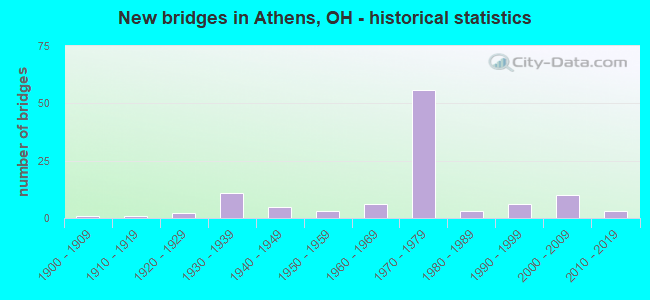
- New bridges - historical statistics
- 11900-1909
- 11910-1919
- 21920-1929
- 111930-1939
- 51940-1949
- 31950-1959
- 61960-1969
- 561970-1979
- 31980-1989
- 61990-1999
- 102000-2009
- 32010-2019

- Reconstructed bridges - Historical Statistics
- 11960-1969
- 51970-1979
- 31980-1989
- 21990-1999
- 12000-2009
- 22010-2019
- 12020-2022


- Bridge Condition - Deck
- 3.8%Excellent
- 17.5%Very good
- 55.0%Good
- 17.5%Satisfactory
- 6.3%Fair

- Bridge Condition - Superstructure
- 3.8%Excellent
- 26.3%Very good
- 43.8%Good
- 15.0%Satisfactory
- 11.3%Fair

- Bridge Condition - Substructure
- 3.8%Excellent
- 22.5%Very good
- 41.3%Good
- 21.3%Satisfactory
- 8.8%Fair
- 1.3%Poor
- 1.3%Serious

- Bridge Condition - Channel
- 5.4%Excellent
- 10.7%Very good
- 16.1%Good
- 42.9%Satisfactory
- 12.5%Fair
- 10.7%Poor
- 1.8%Serious
Find on map >> Show street view
Structure Number: 560146, Location: 0.04M E OF S PLAINS RD (Lat: 39.330431, Lng: -82.127089), Route carried "on" structure: City street UNION, Year Built: 2001, Status: Open, Structure Length: 6.89m (22.60ft), Average Daily Traffic: 9,981 (year 2015), Truck Traffic: 7%, Average Future Daily Traffic: 13,854 (year 2035), Design Load: HS 20+Mod, Features Intersected: Hocking River
Minimum Vertical Clearance: 30+ m (98+ ft), Kilometerpoint: 0.064, Lanes on structure: 2, Owner: City or Municipal Highway Agency, Approaching Roadway Width: 12.2m (40.0ft), Material/Design: Steel continuous, Design/Construction: Stringer/Multi-beam, Number Of Spans In Main Unit: 3, Length of Maximum Span: 25.9m (85.0ft), Curb or Sidewalk Widths: Left: 1.5m (4.9ft), Right: 1.5m (4.9ft), Curb-To-Curb Width: 11.6m (38.1ft), Out-to-Out Width: 12.3m (40.4ft)
Condition: Deck: Very good, Superstructure: Very good, Substructure: Good, Channel: Good, Operating Rating: 74.5 metric tons, Method Used To Determine Operating Rating: Load Factor (LF) rating reported by rating factor (RF) method using MS18 loading, Inventory Rating: 45.4 metric tons, Method Used To Determine Inventory Rating: Load Factor (LF) rating reported by rating factor (RF) method using MS18 loading, Structural Evaluation: Better than present minimum criteria, Deck Geometry: Somewhat better than minimum adequacy, Waterway Adequacy: Superior to present desirable criteria, Approach Roadway Alignment: Equal to present minimum criteria, Designated Inspection Frequency: Every 24 months, Underwater Inspection Frequency: Every 60 months, Inspection Date: June 2021, Underwater Inspection Date: September 2020, Deck Structure Type: Concrete Cast-file-Place, Wearing Surface/Protective System: Wearing Surface: Monolithic Concrete, Membrane: Preformed Fabric
Find on map >> Show street view
Structure Number: 560162, Location: 0.04M N OF S PLAINS RD (Lat: 39.319700, Lng: -82.105319), Route carried "on" structure: City street RICHL, Year Built: 1969, Year Reconstructed: 2010, Status: Open, Structure Length: 11.42m (37.47ft), Average Daily Traffic: 14,196 (year 2015), Truck Traffic: 7%, Average Future Daily Traffic: 21,814 (year 2035), Design Load: HS 20+Mod, Features Intersected: HOCKING RIVER
Minimum Vertical Clearance: 30+ m (98+ ft), Kilometerpoint: 1.899, Lanes on structure: 4, Owner: City or Municipal Highway Agency, Approaching Roadway Width: 15.9m (52.2ft), Skew: 2 degrees, Material/Design: Steel continuous, Design/Construction: Stringer/Multi-beam, Number Of Spans In Main Unit: 4, Length of Maximum Span: 31.4m (103.0ft), Curb or Sidewalk Widths: Left: 3.7m (12.1ft), Right: 0.0m, Curb-To-Curb Width: 15.9m (52.2ft), Out-to-Out Width: 21.1m (69.2ft)
Condition: Deck: Good, Superstructure: Satisfactory, Substructure: Satisfactory, Channel: Good, Operating Rating: 48.6 metric tons, Method Used To Determine Operating Rating: Load Factor (LF) rating reported by rating factor (RF) method using MS18 loading, Inventory Rating: 29.2 metric tons, Method Used To Determine Inventory Rating: Load Factor (LF) rating reported by rating factor (RF) method using MS18 loading, Structural Evaluation: Equal to present minimum criteria, Deck Geometry: Meets minimum limits, Waterway Adequacy: Equal to present desirable criteria, Approach Roadway Alignment: Equal to present minimum criteria, Designated Inspection Frequency: Every 12 months, Inspection Date: June 2021, Deck Structure Type: Concrete Cast-file-Place, Wearing Surface/Protective System: Wearing Surface: Monolithic Concrete, Deck Protection: Epoxy Coated Reinforcing
Find on map >> Show street view
Structure Number: 560189, Location: 150 FT.W.JCT.CO RD. 91 (Lat: 39.330811, Lng: -82.087589), Route carried "on" structure: City street STIMS, Year Built: 1971, Status: Open, Structure Length: 10.85m (35.60ft), Average Daily Traffic: 6,329 (year 2015), Truck Traffic: 7%, Average Future Daily Traffic: 9,724 (year 2035), Design Load: HS 20+Mod, Features Intersected: HOCKING RIVER
Minimum Vertical Clearance: 30+ m (98+ ft), Kilometerpoint: 0.097, Lanes on structure: 2, Owner: City or Municipal Highway Agency, Approaching Roadway Width: 9.8m (32.2ft), Material/Design: Steel continuous, Design/Construction: Stringer/Multi-beam, Number Of Spans In Main Unit: 4, Length of Maximum Span: 29.9m (98.1ft), Curb-To-Curb Width: 13.4m (44.0ft), Out-to-Out Width: 14.1m (46.3ft)
Condition: Deck: Satisfactory, Superstructure: Satisfactory, Substructure: Satisfactory, Channel: Very good, Operating Rating: 55.1 metric tons, Method Used To Determine Operating Rating: Load Factor (LF) rating reported by rating factor (RF) method using MS18 loading, Inventory Rating: 32.4 metric tons, Method Used To Determine Inventory Rating: Load Factor (LF) rating reported by rating factor (RF) method using MS18 loading, Structural Evaluation: Equal to present minimum criteria, Deck Geometry: Equal to present minimum criteria, Waterway Adequacy: Equal to present desirable criteria, Approach Roadway Alignment: Equal to present desirable criteria, Designated Inspection Frequency: Every 12 months, Inspection Date: June 2021, Deck Structure Type: Concrete Cast-file-Place, Wearing Surface/Protective System: Wearing Surface: Bituminous
Find on map >> Show street view
Structure Number: 560308, Location: CORNER OF CARRIAGE HILL (Lat: 39.312100, Lng: -82.103869), Route carried "on" structure: City street CARRI, Year Built: 1967, Year Reconstructed: 2011, Status: Open, Structure Length: 0.94m (3.08ft), Average Daily Traffic: 519 (year 2015), Truck Traffic: 5%, Average Future Daily Traffic: 720 (year 2035), Design Load: HS 20+Mod, Features Intersected: COATES RUN
Minimum Vertical Clearance: 30+ m (98+ ft), Kilometerpoint: 0.322, Lanes on structure: 2, Owner: City or Municipal Highway Agency, Approaching Roadway Width: 7.9m (25.9ft), Skew: 3 degrees, Material/Design: Prestressed concrete, Design/Construction: Box Beam or Girders - Multiple, Number Of Spans In Main Unit: 1, Length of Maximum Span: 9.1m (29.9ft), Curb or Sidewalk Widths: Left: 0.0m, Right: 1.5m (4.9ft), Curb-To-Curb Width: 7.9m (25.9ft), Out-to-Out Width: 9.4m (30.8ft)
Condition: Deck: Very good, Superstructure: Very good, Substructure: Very good, Channel: Good, Operating Rating: 66.1 metric tons, Method Used To Determine Operating Rating: Load Factor (LF) rating reported by rating factor (RF) method using MS18 loading, Inventory Rating: 39.5 metric tons, Method Used To Determine Inventory Rating: Load Factor (LF) rating reported by rating factor (RF) method using MS18 loading, Structural Evaluation: Equal to present desirable criteria, Deck Geometry: Somewhat better than minimum adequacy, Waterway Adequacy: Better than present minimum criteria, Approach Roadway Alignment: Equal to present desirable criteria, Designated Inspection Frequency: Every 24 months, Inspection Date: June 2021, Deck Structure Type: Other, Wearing Surface/Protective System: Wearing Surface: Bituminous
Find on map >> Show street view
Structure Number: 500852, Location: 3.4M E OF JCT SR550 (Lat: 39.325311, Lng: -82.087881), Route carried "under" structure: County highway 25, Year Built: 1978, Structure Length: 0. m, Average Daily Traffic: 4,323 (year 2015), Truck Traffic: 5%, Features Intersected: U.S. ROUTE 33, Facility Carried by Structure: USR 33
Minimum Vertical Clearance: 4.60m (15.09ft), Kilometerpoint: 127.782, Lanes on structure: 2, Lanes under structure: 2, Material/Design: Steel continuous, Design/Construction: Stringer/Multi-beam, Length of Maximum Span: 14.9m (48.9ft)
Find on map >> Show street view
Structure Number: 50086, Location: 3.4M E OF JCT SR550 (Lat: 39.325419, Lng: -82.088081), Route carried "under" structure: County highway 25, Year Built: 1978, Structure Length: 0. m, Average Daily Traffic: 4,323 (year 2015), Truck Traffic: 5%, Features Intersected: U.S. ROUTE 33, Facility Carried by Structure: USR 33
Minimum Vertical Clearance: 4.60m (15.09ft), Kilometerpoint: 128.104, Lanes on structure: 2, Lanes under structure: 2, Material/Design: Steel continuous, Design/Construction: Stringer/Multi-beam, Length of Maximum Span: 14.9m (48.9ft)
Find on map >> Show street view
Structure Number: 500887, Location: 3M E OF JCT SR550 (Lat: 39.329631, Lng: -82.085469), Route carried "under" structure: City street 3Y12, Year Built: 1978, Structure Length: 0. m, Average Daily Traffic: 4,526 (year 2015), Truck Traffic: 7%, Features Intersected: U.S. ROUTE 33, Facility Carried by Structure: USR 33
Minimum Vertical Clearance: 4.57m (14.99ft), Kilometerpoint: 0.000, Lanes on structure: 2, Lanes under structure: 2, Material/Design: Concrete continuous, Design/Construction: Slab, Length of Maximum Span: 14.6m (47.9ft)
Find on map >> Show street view
Structure Number: 500895, Location: 3M E OF JCT SR550 (Lat: 39.329769, Lng: -82.085661), Route carried "under" structure: City street 3Y12, Year Built: 1975, Structure Length: 0. m, Average Daily Traffic: 4,526 (year 2015), Truck Traffic: 7%, Features Intersected: U.S. 33 & U.S. 50, Facility Carried by Structure: USR 33
Minimum Vertical Clearance: 4.57m (14.99ft), Kilometerpoint: 0.000, Lanes on structure: 3, Lanes under structure: 2, Material/Design: Concrete continuous, Design/Construction: Slab, Length of Maximum Span: 14.6m (47.9ft)
Find on map >> Show street view
Structure Number: 500917, Location: 0.16M E OF SR 682 (Lat: 39.315669, Lng: -82.096050), Route carried "under" structure: US 33, Year Built: 1978, Structure Length: 0. m, Average Daily Traffic: 23,088 (year 2016), Truck Traffic: 10%, Features Intersected: HOOPER ST TR-402, Facility Carried by Structure: HOOPER ST TR-402
Minimum Vertical Clearance: 5.82m (19.09ft), Kilometerpoint: 25.357, Lanes on structure: 2, Lanes under structure: 4, Material/Design: Steel continuous, Design/Construction: Stringer/Multi-beam, Length of Maximum Span: 33.1m (108.6ft)
Find on map >> Show street view
Structure Number: 500925, Location: 1.95 M S OF SR56 (Lat: 39.314319, Lng: -82.098431), Route carried "under" structure: US 33, Year Built: 1978, Structure Length: 0. m, Average Daily Traffic: 21,838 (year 2015), Truck Traffic: 7%, Features Intersected: SR-682, Facility Carried by Structure: S.R. 682
Minimum Vertical Clearance: 4.98m (16.34ft), Kilometerpoint: 25.638, Lanes on structure: 2, Lanes under structure: 5, Material/Design: Steel continuous, Design/Construction: Stringer/Multi-beam, Length of Maximum Span: 23.8m (78.1ft)
Find on map >> Show street view
Structure Number: 500941, Location: 0.5M E OF SR682 (Lat: 39.311550, Lng: -82.103350), Route carried "under" structure: County highway C500, Year Built: 1979, Structure Length: 0. m, Average Daily Traffic: 6,228 (year 2015), Truck Traffic: 7%, Features Intersected: U.S. ROUTE 33, Facility Carried by Structure: USR 33
Minimum Vertical Clearance: 4.88m (16.01ft), Kilometerpoint: 0.830, Lanes on structure: 3, Lanes under structure: 2, Material/Design: Steel continuous, Design/Construction: Stringer/Multi-beam, Length of Maximum Span: 26.2m (86.0ft)
Find on map >> Show street view
Structure Number: 501018, Location: 0.5M E OF SR682 (Lat: 39.311811, Lng: -82.103350), Route carried "under" structure: City street 3Y05, Year Built: 1979, Structure Length: 0. m, Average Daily Traffic: 6,228 (year 2015), Truck Traffic: 7%, Features Intersected: U.S. ROUTE 33, Facility Carried by Structure: USR 33
Minimum Vertical Clearance: 4.70m (15.42ft), Kilometerpoint: 0.000, Lanes on structure: 3, Lanes under structure: 2, Material/Design: Steel continuous, Design/Construction: Stringer/Multi-beam, Length of Maximum Span: 23.5m (77.1ft)
Find on map >> Show street view
Structure Number: 501026, Location: 1.6KM S OF JCT. S.R. 682 (Lat: 39.303661, Lng: -82.103739), Route carried "under" structure: County highway 513, Year Built: 2002, Structure Length: 0. m, Average Daily Traffic: 5,575 (year 2015), Truck Traffic: 7%, Features Intersected: US.33, Facility Carried by Structure: USR 33
Minimum Vertical Clearance: 5.66m (18.57ft), Kilometerpoint: 30.578, Lanes on structure: 2, Lanes under structure: 2, Material/Design: Prestressed concrete continuous, Design/Construction: Stringer/Multi-beam, Length of Maximum Span: 28.9m (94.8ft)
Find on map >> Show street view
Structure Number: 501034, Location: 1.6KM S OF JCT. S.R. 682 (Lat: 39.303519, Lng: -82.103989), Route carried "under" structure: County highway 513, Year Built: 2002, Structure Length: 0. m, Average Daily Traffic: 5,575 (year 2015), Truck Traffic: 7%, Features Intersected: U.S.R. 33, Facility Carried by Structure: USR 33
Minimum Vertical Clearance: 5.66m (18.57ft), Kilometerpoint: 0.274, Lanes on structure: 2, Lanes under structure: 2, Material/Design: Prestressed concrete continuous, Design/Construction: Stringer/Multi-beam, Length of Maximum Span: 28.9m (94.8ft)
Find on map >> Show street view
Structure Number: 501069, Location: 1.76 Mi South of US 50 (Lat: 39.278361, Lng: -82.099350), Route carried "under" structure: US 33, Year Built: 2002, Structure Length: 0. m, Average Daily Traffic: 11,700 (year 2015), Truck Traffic: 5%, Features Intersected: TR 55 over US 33, Facility Carried by Structure: TR 55
Minimum Vertical Clearance: 5.84m (19.16ft), Kilometerpoint: 30.143, Lanes on structure: 2, Lanes under structure: 4, Material/Design: Prestressed concrete continuous, Design/Construction: Stringer/Multi-beam, Length of Maximum Span: 37.0m (121.4ft)
Find on map >> Show street view
Structure Number: 501107, Location: 7.5KM N OF JCT. SR 682 (Lat: 39.256689, Lng: -82.082789), Route carried "under" structure: US 33, Year Built: 2002, Structure Length: 0. m, Average Daily Traffic: 6,556 (year 2015), Truck Traffic: 9%, Features Intersected: TR 64, Facility Carried by Structure: TR 64
Minimum Vertical Clearance: 5.77m (18.93ft), Kilometerpoint: 35.261, Lanes on structure: 2, Lanes under structure: 4, Material/Design: Concrete continuous, Design/Construction: Stringer/Multi-beam, Length of Maximum Span: 35.0m (114.8ft)
Find on map >> Show street view
Structure Number: 501468, Location: 8.1M E OF JCT SR690 (Lat: 39.305500, Lng: -82.105661), Route carried "under" structure: Ramp US 33, Year Built: 1979, Structure Length: 0. m, Average Daily Traffic: 11,700 (year 2009), Truck Traffic: 9%, Features Intersected: U.S. ROUTE 50, Facility Carried by Structure: USR 50
Minimum Vertical Clearance: 4.60m (15.09ft), Kilometerpoint: 29.097, Lanes on structure: 2, Lanes under structure: 3, Material/Design: Steel continuous, Design/Construction: Stringer/Multi-beam, Length of Maximum Span: 47.5m (155.8ft)
Find on map >> Show street view
Structure Number: 501484, Location: 8.3 M E OF JCT SR690 (Lat: 39.302489, Lng: -82.104931), Route carried "under" structure: City street 3Y05, Year Built: 1979, Structure Length: 0. m, Average Daily Traffic: 5,575 (year 2015), Truck Traffic: 7%, Features Intersected: U.S.R. 50 EASTBOUND, Facility Carried by Structure: USR 50
Minimum Vertical Clearance: 4.60m (15.09ft), Kilometerpoint: 83.686, Lanes on structure: 2, Lanes under structure: 4, Material/Design: Steel continuous, Design/Construction: Stringer/Multi-beam, Length of Maximum Span: 30.9m (101.4ft)
Find on map >> Show street view
Structure Number: 501514, Location: 8.1M E OF JCT SR690 (Lat: 39.304881, Lng: -82.105169), Route carried "under" structure: Ramp US 33, Year Built: 1979, Structure Length: 0. m, Average Daily Traffic: 11,700 (year 2009), Truck Traffic: 9%, Features Intersected: U.S. ROUTE 50, Facility Carried by Structure: USR 50
Minimum Vertical Clearance: 4.60m (15.09ft), Kilometerpoint: 29.161, Lanes on structure: 2, Lanes under structure: 3, Material/Design: Steel continuous, Design/Construction: Stringer/Multi-beam, Length of Maximum Span: 48.2m (158.1ft)
Find on map >> Show street view
Structure Number: 501549, Location: E STIMSON AVE/50 E RAMP (Lat: 39.331619, Lng: -82.082661), Route carried "under" structure: US 50, Year Built: 1975, Structure Length: 0. m, Average Daily Traffic: 9,934 (year 2016), Truck Traffic: 12%, Features Intersected: USR 33, Facility Carried by Structure: STIMSON AVE
Minimum Vertical Clearance: 5.26m (17.26ft), Kilometerpoint: 22.864, Lanes on structure: 2, Lanes under structure: 4, Material/Design: Steel continuous, Design/Construction: Stringer/Multi-beam, Length of Maximum Span: 26.7m (87.6ft)
Find on map >> Show street view
Structure Number: 501611, Location: 2.5 MI W OF JCT SR690 (Lat: 39.333739, Lng: -82.035600), Route carried "under" structure: Business County highway C0040, Year Built: 1975, Structure Length: 0. m, Average Daily Traffic: 4,083 (year 2017), Features Intersected: US 50, Facility Carried by Structure: USR 50
Minimum Vertical Clearance: 6.50m (21.33ft), Kilometerpoint: 5.993, Lanes on structure: 3, Lanes under structure: 2, Material/Design: Steel continuous, Design/Construction: Stringer/Multi-beam, Length of Maximum Span: 25.3m (83.0ft)
Find on map >> Show street view
Structure Number: 501638, Location: 2.5 MI W OF JCT SR690 (Lat: 39.333750, Lng: -82.035131), Route carried "under" structure: Business County highway C0040, Year Built: 1975, Structure Length: 0. m, Average Daily Traffic: 4,083 (year 2017), Features Intersected: US 50, Facility Carried by Structure: USR 50
Minimum Vertical Clearance: 6.50m (21.33ft), Kilometerpoint: 5.993, Lanes on structure: 2, Lanes under structure: 2, Material/Design: Steel continuous, Design/Construction: Stringer/Multi-beam, Length of Maximum Span: 25.3m (83.0ft)
Find on map >> Show street view
Structure Number: 50475, Location: 0.1M NW OF JCT USR 33 (Lat: 39.314939, Lng: -82.099100), Route carried "under" structure: State highway 682, Year Built: 1978, Structure Length: 0. m, Average Daily Traffic: 4,373 (year 2016), Truck Traffic: 3%, Features Intersected: HOOPER ST TR-402, Facility Carried by Structure: HOOPER ST TR-402
Minimum Vertical Clearance: 5.11m (16.77ft), Kilometerpoint: 0.288, Lanes on structure: 2, Lanes under structure: 2, Material/Design: Steel continuous, Design/Construction: Stringer/Multi-beam, Length of Maximum Span: 20.9m (68.6ft)
Find on map >> Show street view
Structure Number: 505781, Location: SR 550 (Lat: 39.361200, Lng: -82.106681), Route carried "under" structure: State highway 550, Year Built: 1970, Structure Length: 0. m, Average Daily Traffic: 7,248 (year 2015), Truck Traffic: 3%, Features Intersected: U.S. 33, Facility Carried by Structure: USR 33
Minimum Vertical Clearance: 6.10m (20.01ft), Kilometerpoint: 45.062, Lanes on structure: 2, Lanes under structure: 4, Material/Design: Steel continuous, Design/Construction: Stringer/Multi-beam, Length of Maximum Span: 26.8m (87.9ft)
Find on map >> Show street view
Structure Number: 505803, Location: SR 550 (Lat: 39.361050, Lng: -82.106789), Route carried "under" structure: State highway 550, Year Built: 1970, Structure Length: 0. m, Average Daily Traffic: 7,248 (year 2015), Truck Traffic: 3%, Features Intersected: U.S. 33, Facility Carried by Structure: USR 33
Minimum Vertical Clearance: 7.16m (23.49ft), Kilometerpoint: 41.843, Lanes on structure: 2, Lanes under structure: 4, Material/Design: Steel continuous, Design/Construction: Stringer/Multi-beam, Length of Maximum Span: 26.8m (87.9ft)
Find on map >> Show street view
Structure Number: 505811, Location: 1.12 M SE og SR550 (Lat: 39.351711, Lng: -82.089381), Route carried "under" structure: US 33, Year Built: 1971, Structure Length: 0. m, Average Daily Traffic: 24,917 (year 2015), Truck Traffic: 4%, Features Intersected: CR 20, Facility Carried by Structure: CR 20
Minimum Vertical Clearance: 5.11m (16.77ft), Kilometerpoint: 22.885, Lanes on structure: 2, Lanes under structure: 4, Material/Design: Steel continuous, Design/Construction: Stringer/Multi-beam, Length of Maximum Span: 20.1m (65.9ft)
Find on map >> Show street view
Structure Number: 505838, Location: 2.8M E OF JCT SR682 (Lat: 39.337581, Lng: -82.081431), Route carried "under" structure: City street 3Y17, Year Built: 1970, Structure Length: 0. m, Average Daily Traffic: 10,215 (year 2015), Truck Traffic: 1%, Features Intersected: U.S. 33, Facility Carried by Structure: USR 33
Minimum Vertical Clearance: 5.21m (17.09ft), Kilometerpoint: 24.591, Lanes on structure: 2, Lanes under structure: 4, Material/Design: Steel, Design/Construction: Stringer/Multi-beam, Length of Maximum Span: 30.5m (100.1ft)
Find on map >> Show street view
Structure Number: 505846, Location: 2.8M E OF JCT SR682 (Lat: 39.337600, Lng: -82.081700), Route carried "under" structure: City street 3Y17, Year Built: 1970, Structure Length: 0. m, Average Daily Traffic: 10,215 (year 2015), Truck Traffic: 1%, Features Intersected: U.S. 33, Facility Carried by Structure: USR 33
Minimum Vertical Clearance: 5.44m (17.85ft), Kilometerpoint: 24.591, Lanes on structure: 2, Lanes under structure: 4, Material/Design: Steel, Design/Construction: Stringer/Multi-beam, Length of Maximum Span: 30.5m (100.1ft)
Find on map >> Show street view
Structure Number: 506125, Location: U.S.R. 33 WESTBOUND (Lat: 39.331739, Lng: -82.082181), Route carried "under" structure: US 50, Year Built: 1975, Structure Length: 0. m, Average Daily Traffic: 7,396 (year 2015), Truck Traffic: 9%, Features Intersected: U.S. 33, Facility Carried by Structure: USR 33
Minimum Vertical Clearance: 5.28m (17.32ft), Kilometerpoint: 22.901, Lanes on structure: 2, Lanes under structure: 4, Material/Design: Steel continuous, Design/Construction: Stringer/Multi-beam, Length of Maximum Span: 21.9m (71.9ft)
Find on map >> Show street view
Structure Number: 560111, Location: 0.15M N OF S GREEN DR (Lat: 39.325661, Lng: -82.103469), Route carried "under" structure: Other road OXBOW, Year Built: 1932, Structure Length: 0. m, Average Daily Traffic: 100 (year 2021), Truck Traffic: 1%, Features Intersected: RICHLAND AVE
Minimum Vertical Clearance: 5.79m (19.00ft), Kilometerpoint: 0.322, Lanes on structure: 2, Lanes under structure: 2, Material/Design: Steel, Design/Construction: Girder and Floorbeam System, Length of Maximum Span: 24.4m (80.1ft)